Hill City is the oldest existing city in Pennington County, South Dakota, United States. The population was 948 at the 2010 census. Hill City is located 26 miles (42 km) southwest of Rapid City on U.S. Highway 16 and on U.S. Route 385 that connects Deadwood to Hot Springs. Hill City is known as the "Heart of the Hills" which is derived from its close proximity to both the geographical center of the Black Hills, and the local tourist destinations.

The American Discovery Trail is a system of recreational trails and roads which collectively form a coast-to-coast hiking and biking trail across the mid-tier of the United States. Horses can also be ridden on most of this trail. It starts on the Delmarva Peninsula on the Atlantic Ocean and ends on the northern California coast on the Pacific Ocean. The trail has northern and southern alternates for part of its distance, passing through Chicago and St. Louis respectively. The total length of the trail including both the north and south routes is 6,800 miles (10,900 km). The northern route covers 4,834 miles (7,780 km) with the southern route covering 5,057 miles (8,138 km). It is the only non-motorized coast-to-coast trail.

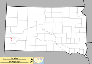
French Creek is an intermittent stream located in the Black Hills region of western South Dakota, United States. It is a tributary of the Cheyenne River. French Creek flows year-round, but in drier periods it flows into an underground drainage near the eastern boundary of Custer State Park and never reaches the Cheyenne.

The OC&E Woods Line State Trail is a rail trail in Klamath and Lake counties in the U.S. state of Oregon. It is Oregon's longest state park. The trail follows the old OC&E and Weyerhaeuser railroads from Klamath Falls to Thompson Reservoir. Along its 105-mile (169 km) length it passes through the communities of Olene, Sprague River, Dairy, Beatty, and Bly.

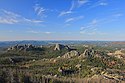
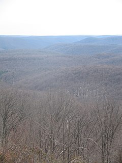
Black Hills National Forest is located in southwestern South Dakota and northeastern Wyoming, United States. The forest has an area of over 1.25 million acres (5,066 km²) and is managed by the Forest Service. Forest headquarters are located in Custer, South Dakota. There are local ranger district offices in Custer, Rapid City, and Spearfish in South Dakota, and in Sundance, Wyoming.
U.S. Route 16A is a 36.971-mile-long (59.499 km) scenic United States highway. It is an alternate route for US 16. It splits from US 16 in the Black Hills of the southwestern part of the U.S. state of South Dakota. The highway's western terminus is an intersection with US 16, US 385, and South Dakota Highway 89 (SD 89) in Custer, South Dakota. The eastern terminus is at an interchange with US 16 called the Keystone Wye south of Rapid City, South Dakota. Portions of US 16A are known as the Iron Mountain Road.

St. Croix State Park is a state park in Pine County, Minnesota, USA. The park follows the shore of the St. Croix River for 21 miles (34 km) and contains the last 7 miles (11 km) of the Kettle River. At 33,895 acres (13,717 ha) it is the largest Minnesota state park. It was developed as a Recreational Demonstration Area in the 1930s, and is one of the finest surviving properties of this type in the nation. 164 structures built by the Civilian Conservation Corps and the Works Progress Administration survive, the largest collection of New Deal projects in Minnesota. As a historic district they were listed on the National Register of Historic Places and proclaimed a National Historic Landmark in 1997.
This is a list of trails in Ithaca, New York.

Swatara State Park is a 3,515-acre (1,422 ha) Pennsylvania state park in Bethel, Swatara and Union Townships, Lebanon and Pine Grove Township, Schuylkill Counties in Pennsylvania in the United States. 8 miles (13 km) of Swatara Creek lie within the park's boundaries, which are roughly formed by Pennsylvania Route 443 to the north and Interstate 81 to the south. The park is in a valley in the ridge and valley region of Pennsylvania between Second Mountain (north) and Blue Mountain (south).
South Dakota Highway 87 (SD 87) is a 37.894-mile-long (60.984 km) state highway in the southwestern part of the U.S. state of South Dakota. It travels through the Black Hills region. The highway's southern terminus is at an intersection with U.S. Route 385 (US 385), about 6 miles (9.7 km) southeast of Pringle, within the southwestern part of Wind Cave National Park. Its northern terminus is at an intersection with US 16/US 385 about 3 miles (4.8 km) south-southwest of Hill City, within the east-central part of the Black Hills National Forest.

The Pine Creek Rail Trail is a rail trail in the Appalachian Mountains of north-central Pennsylvania.
The Susquehannock Trail System is an 85-mile (137 km) loop hiking trail in the Susquehannock State Forest in Potter and Clinton counties in north-central Pennsylvania in the United States. The trail goes through three state parks and passes within 2 miles (3 km) of three more state parks. Other highlights include a fire tower, vistas, and the Hammersley Wild Area, the largest area in Pennsylvania without a road. The STS was founded by William Fish Jr. in 1966 and is maintained by the Susquehannock Trail Club in cooperation with the Pennsylvania Department of Conservation and Natural Resources (DCNR). In the south it shares 8.7 miles (14.0 km) of its course in Clinton County with the 90-mile (140 km) Donut Hole Trail. The STS also connects to the east with the Black Forest Trail in Lycoming County via two short link trails.
The Sidney Black Hills Stage Road or Route was a trail connecting Sidney, Nebraska, Sidney Barracks, and the Union Pacific Railroad with Fort Robinson, Red Cloud Agency, Spotted Tail Agency, Custer City, Dakota Territory, and Deadwood, Dakota Territory between 1876 and 1887, when it was replaced.
The Dakota Rail Trail runs 26.5 miles (42.6 km) from Wayzata to Mayer, Minnesota. Heading west from Wayzata the first 13 miles are in Hennepin County, Minnesota, and the next 13.5 miles are in Carver County, Minnesota. Along the way it runs through many towns including Spring Park and St. Bonifacius.

Dewey is an unincorporated community near the southwest corner of Custer County, South Dakota, less than 1 mile from the Wyoming border in a prairie region of the Black Hills. There are approximately five or six homes in town. Dewey has a volunteer fire department in the Edgemont city district.
At least 12 special routes of U.S. Route 16 have existed, including four in Michigan.
The Black Hills and Fort Pierre Railroad (BH&FP) was a 3 ft narrow gauge railroad in the Black Hills of the U.S. state of South Dakota. It was created by the Homestake Mining Company and initially ran from Lead to Calcite and Piedmont by way of Elk Creek. An alternate route was established to Piedmont and Calcite by way of Nemo and Stagebarn Canyon after numerous washouts made the Elk Creek route unviable. There was also a branch from the Nemo line connecting Este with a logging camp at Merritt. The railroad had 6.180 miles (9.946 km) of dual gauge track and another 47.618 miles (76.634 km) of 3 ft track; the total amount of track was 53.798 miles (86.579 km).
Cicero Peak is a 6,168-foot (1,880 m) mountain in the Black Hills of Custer County, South Dakota. The mountain is 6 miles (9.7 km) south-southeast of the city of Custer, southwest of Custer State Park, and northwest of Wind Cave National Park. The closest community is Sanator, which is about 2 miles (3.2 km) northwest of Cicero Peak.
U.S. Route 385 (US 385) is a part of the United States Numbered Highway System that travels from Big Bend National Park in Texas to US 85 in Deadwood, South Dakota. Within the state of Nebraska, the highway is known as the Gold Rush Byway, one of nine scenic byways across the state. The highway follows along the old Sidney-Black Hills trail which played a crucial role during the Black Hills Gold Rush in the late 1870s. It served as the primary route to transport gold and mining gear between Sidney, Nebraska and the Black Hills to the north. Today, the highway enters Nebraska in the southeastern portion of the Nebraska Panhandle on the state line with Colorado northeast of Julesburg and continues in a northerly direction to the South Dakota state line north of Chadron.