
Hill City is the oldest existing city in Pennington County, South Dakota, United States. The population was 948 at the 2010 census. Hill City is located 26 miles (42 km) southwest of Rapid City on U.S. Highway 16 and on U.S. Route 385 that connects Deadwood to Hot Springs. Hill City is known as the "Heart of the Hills", a distinction derived from its proximity to both the geographical center of the Black Hills, and the local tourist destinations.
The tin mining industry on Dartmoor, Devon, England, is thought to have originated in pre-Roman times, and continued right through to the 20th century, when the last commercially worked mine closed in November 1930. From the 12th century onwards tin mining was regulated by a stannary parliament which had its own laws.

Drakelands Mine, formerly known as Hemerdon Mine or the Hemerdon Ball or Hemerdon Bal Mine, is a tungsten and tin mine. It is located 11 km northeast of Plymouth, near Plympton, in Devon, England. It lies to the north of the villages of Sparkwell and Hemerdon and adjacent to the large china clay pits near Lee Moor. The mine was out of operation since 1944, except for the brief operation of a trial mine in the 1980s. Work started to re-open it in 2014, but it ceased activities in 2018. It hosts the fourth largest tin-tungsten deposit in the world.

Ragged Top is a ghost town in Lawrence County, South Dakota, United States. While the town was once a prosperous mining town, it declined due to miners' inability to transport their ore to smelters.
Carbonate, also known as Carbonate Camp, West Virginia, Virginia, and Carbonate City (1881-1939), is a ghost town located in Lawrence County, South Dakota, United States.
Addie Camp, also known as Kennedyville, Addie Spur, or Canadaville, is a ghost town located in Pennington County, South Dakota, United States. It was a mining camp in the Black Hills.

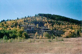
Cambria (1889-1928) is a ghost town located in the Black Hills of Weston County, Wyoming, United States. It was a successful coal mining town for decades.

Tinton is a ghost town in the Black Hills of Lawrence County, South Dakota, United States. It started out as a gold mining camp and later began to produce tin.
Tigerville or Tiger City (1878–1885) is a ghost town in the Black Hills of Pennington County, South Dakota, United States. The old mining town exemplifies the boom-and-bust fate of many Western towns.
Trojan, also known as Portland (?-1959), is a ghost town in the Black Hills of Lawrence County, South Dakota, United States. It was created by the Trojan Mining Company.
Flatiron, formerly known as Yellow Creek or Flat Iron City, is a ghost town in Lawrence County, South Dakota, United States. It was known for its highly successful gold mining.
Maitland, originally called Garden City and sometimes misspelled Midland, is a ghost town in Lawrence County, South Dakota, United States. It was a mining community that boomed during the Black Hills Gold Rush, but was abandoned by about 1915.
Myers City, today called Myersville, is a ghost town in Pennington County, South Dakota, United States.
Rochford is an unincorporated community in Pennington County, South Dakota, United States. It is not tracked by the U.S. Census Bureau.
Roubaix, formerly known as Perry or Lewisville, is an unincorporated community in Lawrence County, South Dakota, United States. It is not monitored by the U.S. Census Bureau.

Twin Buttes is a populated place on the east flank of the Sierrita Mountains about twenty miles south of Tucson, in Pima County, Arizona. Named after a prominent hill located next to the town, Twin Buttes was founded as a small mining town around 1903 and abandoned around 1930. Much of the actual town site is now buried underneath mine tailings, and all that remains is the Twin Buttes Cemetery.
Galena is an unincorporated community in Lawrence County, South Dakota, United States. It is often considered to be a ghost town, even though a few families still live in the area. It is not tracked by the U.S. Census Bureau.

Terraville is a ghost town in Lawrence County, South Dakota, United States. It was founded in 1877 as a mining camp and later evolved into a town. It was purchased by the Homestake Mining Company and was destroyed in 1982 to make way for a new mine.

Irvinebank State Treatment Works is a heritage-listed refinery off Jessie Street, Irvinebank, Shire of Mareeba, Queensland, Australia. It was built from 1883 to c. 1908. It is also known as Loudoun Mill. It was added to the Queensland Heritage Register on 21 October 1992.

Ottery Mine is a heritage-listed former mine located 8 km north-east of Emmaville, Glen Innes Severn, New South Wales, Australia. It was built from 1882 to 1939. The property is owned by the New South Wales Department of Primary Industries. It was added to the New South Wales State Heritage Register on 2 April 1999.

