Rochford, South Dakota

Last updated

Rochford, South Dakota
USA South Dakota location map.svg
Red pog.svg
Rochford
Location of Rochford in South Dakota.
Coordinates: 44°07′28″N103°43′11″W / 44.1244280°N 103.7196408°W / 44.1244280; -103.7196408 [1]
Country United States
State South Dakota
County Pennington
Township Rochford
FoundedMay 1878
Founded byR.B. Hughes and M. D. Rochford
Elevation
[1]
5,302 ft (1,616 m)
Time zone UTC-7 (Mountain Time Zone (MST))
  Summer (DST) UTC-6 (MDT)

Rochford (founded May 1878) is an unincorporated community in Pennington County, South Dakota, United States. It is not tracked by the U.S. Census Bureau.

Contents

Naming

Rochford was named in honor of one of its founders, M. D. Rochford, in May 1878. [2] [3]

History

Founding and local mining operations

In August 1876, three hunters accidentally discovered what became the Montezuma Gold Mine. Hopeful placer miners from Lead and Central City flocked to the area, staking claims along Little Rapid Creek. [4] The first cabin that established the future site of Rochford was started in February 1877 when M. D. Rochford built a cabin there. In March 1877, an official mining district was set up in the area. In May 1878, Rochford, who was the county commissioner, and R. B. Hughes laid out the town in a gulch. Mining operations in the area included the Silver Reef, Resumption, Pride of the West, Oro Cache, Rattler, Mountain Treasure, Justin, Glenwood, Little Woodchuck, Ethan Allen, Wide West, and Surprise Fraction, as well as branches of the Homestake Mining Company. [5] The town made its profit from the local Evangeline and Minnesota gold mines, which each had a 20-stamp mill; and the Stand-By mine. The Stand-By 40-stamp mill planned in 1879 used a flume to haul water and create power. [2] There was a large office at this mill that the locals nicknamed "The Mansion," though it was torn down some time before 1950. [4] This mine and mill contributed to much of Rochford's growth. A sawmill produced 900,000 feet (270,000 m) of lumber for the operations. The mill's building was delayed in March 1880 due to the freight train's inability to make it to the mill, due to a snowfall of 4 feet (1.2 m). Though the mill was running 60-stamps by May 1880, it closed in 1881, and from there began running intermittently until 1936. [5]

Growth

By December 1878, the town had a population of 500, including a few doctors, a Methodist Episcopal Church, three saloons, six stores, and 100 homes. Property was sold for anywhere from $10 to $60. However, there were not yet any dance halls, casinos, or hotels. Several Deadwood businessmen showed interest in extending their companies to Rochford, but they were put off by the lack of a daily postal service and mills. Other local camps included Montezuma, Golden Centre, Tigerville, Montana City, Ochre City, Sitting Bull, Florence, Castleton, and Elkorn. [5]

By January 1879, two hotels, a theater, a butcher shop, two restaurants, two blacksmith shops, and a drugstore had been added. The Reder Brothers Sawmill was moved from Rockerville to provide lumber for the town's buildings; by January 1879, it had produced 100,000 feet (30,000 m) of lumber and 50,000 feet (15,000 m) of roof shingles. Lawrence County funded the building of a highway to connect the town to Deadwood for $300. This was a strategic move for Deadwood businessmen, who wanted to divert trade from Rapid City. For a time, it was rumored that the western part of Pennington County would split and become Martin County, and would make Rochford the county seat, but no such action was ever taken. That year, Rochford worried that the nearby camp of Golden Centre would take over as the central point of trade. In 1880, the U.S. Census Bureau recorded 315 residents. Rochford added a pool parlor and a newspaper, "The Central." The Langrishe Theatre Company once performed at the Rochford theatre. The Rochford School District was organized in April 1880. Another newspaper, "The Rochford Miner", surfaced, but it was discontinued in 1881. [5] At its peak, there were 200 homes, a school, and a street lined with stores and covered sidewalks. [2] Rochford was the home of pioneer Annie D. Tallent in the 1880s. Between 1880 and 1882, the town started to decline, but in September 1882, the Black Hills Times in Deadwood reported that Rochford had picked up in activity. [4]

Later history and today

The town was down to 48 residents and a post office by 1900. [2] No one in the town died until January 1904, when a man called Alex McCall was accidentally shot; therefore, there was no cemetery for a long time. [5] A few mines in the area are still running. The town relies on these mines and tourism. Several historic buildings are still standing, but others have fallen into disrepair. [2] Today, there is a population of 25. [6] In the 1950s, only the Moonshine Gulch Saloon, Irish Gulch Dance Hall, and one store were open. The Moonshine Gulch Saloon is still in operation. Today, the town survives solely on tourism. [4]

Geography

Rochford is in the Black Hills just south of the border between Lawrence and Pennington counties; it is located in the latter. Its coordinates are 44°07′28″N103°43′11″W / 44.1244280°N 103.7196408°W / 44.1244280; -103.7196408 . [1] Rochford is approximately 16 miles northwest of Hill City, [2] 1.5 miles north of Florence, and about 2.5 miles northeast of Myers City. [5] It is on a gravel road that connects it to Mystic, Lead, South Dakota, and Deadwood. [2] Rochford was built in a gulch near Rapid Creek. [4]

Climate

Rochford has a humid continental climate (Koppen: Dwb) with four distinct seasons. Summers are warm, sometimes hot, and winters are cold with very chilly nights. A freeze has been recorded for every month of the year. Precipitation peaks during late spring and slowly decreases with each passing month until it reached .28 inches of precipitation (7.1 mm) in the month of January before it rises again. [7]

Climate data for Rochford 2 WNW, South Dakota, 1991–2020 normals, 1897-2020 extremes: 5450ft (1661m)
MonthJanFebMarAprMayJunJulAugSepOctNovDecYear
Record high °F (°C)62
(17)
63
(17)
73
(23)
83
(28)
86
(30)
97
(36)
100
(38)
104
(40)
94
(34)
87
(31)
74
(23)
67
(19)
104
(40)
Mean maximum °F (°C)55.8
(13.2)
56.4
(13.6)
63.9
(17.7)
71.3
(21.8)
79.8
(26.6)
86.7
(30.4)
91.6
(33.1)
89.2
(31.8)
84.8
(29.3)
77.6
(25.3)
62.4
(16.9)
55.7
(13.2)
92.8
(33.8)
Mean daily maximum °F (°C)36.8
(2.7)
37.2
(2.9)
45.1
(7.3)
50.9
(10.5)
59.7
(15.4)
71.4
(21.9)
79.8
(26.6)
78.8
(26.0)
71.2
(21.8)
56.3
(13.5)
44.4
(6.9)
36.5
(2.5)
55.7
(13.2)
Daily mean °F (°C)19.7
(−6.8)
20.7
(−6.3)
28.3
(−2.1)
36.1
(2.3)
45.1
(7.3)
55.1
(12.8)
61.7
(16.5)
59.5
(15.3)
51.3
(10.7)
38.8
(3.8)
28.2
(−2.1)
21.3
(−5.9)
38.8
(3.8)
Mean daily minimum °F (°C)2.6
(−16.3)
4.2
(−15.4)
11.6
(−11.3)
21.3
(−5.9)
30.6
(−0.8)
38.7
(3.7)
43.7
(6.5)
40.3
(4.6)
31.5
(−0.3)
21.4
(−5.9)
12.0
(−11.1)
6.1
(−14.4)
22.0
(−5.5)
Mean minimum °F (°C)−20.9
(−29.4)
−21.1
(−29.5)
−12.9
(−24.9)
2.1
(−16.6)
16.3
(−8.7)
27.2
(−2.7)
32.4
(0.2)
29.9
(−1.2)
19.9
(−6.7)
2.8
(−16.2)
−9.1
(−22.8)
−18.7
(−28.2)
−32.0
(−35.6)
Record low °F (°C)−36
(−38)
−46
(−43)
−38
(−39)
−15
(−26)
3
(−16)
23
(−5)
25
(−4)
22
(−6)
11
(−12)
−18
(−28)
−22
(−30)
−60
(−51)
−60
(−51)
Average precipitation inches (mm)0.59
(15)
0.66
(17)
1.05
(27)
2.08
(53)
3.43
(87)
3.25
(83)
3.28
(83)
1.96
(50)
1.41
(36)
1.76
(45)
0.92
(23)
0.65
(17)
21.04
(536)
Average snowfall inches (cm)12.0
(30)
12.6
(32)
12.7
(32)
15.0
(38)
3.7
(9.4)
0.7
(1.8)
0.0
(0.0)
0.0
(0.0)
1.4
(3.6)
8.2
(21)
10.8
(27)
11.5
(29)
88.6
(223.8)
Source 1: NOAA [8]
Source 2: XMACIS (1991-2006 precip/snowfall, records & monthly max/mins) [9]
Climate data for Rochford, South Dakota
MonthJanFebMarAprMayJunJulAugSepOctNovDecYear
Record high °F (°C)68
(20)
68
(20)
78
(26)
85
(29)
93
(34)
99
(37)
101
(38)
98
(37)
98
(37)
86
(30)
75
(24)
65
(18)
101
(38)
Mean daily maximum °F (°C)37
(3)
38
(3)
44
(7)
51
(11)
61
(16)
71
(22)
79
(26)
78
(26)
69
(21)
56
(13)
44
(7)
36
(2)
55
(13)
Mean daily minimum °F (°C)11
(−12)
11
(−12)
17
(−8)
25
(−4)
35
(2)
44
(7)
50
(10)
48
(9)
38
(3)
28
(−2)
19
(−7)
11
(−12)
28
(−2)
Record low °F (°C)−34
(−37)
−34
(−37)
−24
(−31)
−8
(−22)
13
(−11)
24
(−4)
29
(−2)
27
(−3)
15
(−9)
−8
(−22)
−21
(−29)
−35
(−37)
−35
(−37)
Average precipitation inches (mm)0.28
(7.1)
0.51
(13)
1.13
(29)
2.15
(55)
3.97
(101)
3.20
(81)
2.72
(69)
2.26
(57)
1.67
(42)
1.50
(38)
0.61
(15)
0.34
(8.6)
20.34
(517)
Source: The Weather Channel (Historical Monthly Averages) [10]

Demographics

In 1880, there were 315 people living in Rochford, and by 1900, there were 48 residents. [5] In 2010, there were only 25 residents. [6]

Notable person

Elmer Ballard, actor, best known for his supporting role in Alibi (1929 film)

Related Research Articles

<span class="mw-page-title-main">Pennington County, South Dakota</span> County in South Dakota, United States

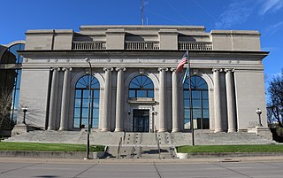
Pennington County is a county in the U.S. state of South Dakota. As of the 2020 census, the population was 109,222, making it the second-most populous county in South Dakota. Its county seat is Rapid City. The county was created in 1875, and was organized in 1877. It is named for John L. Pennington, fifth Governor of Dakota Territory, who held office in 1875 when the county was formed.

<span class="mw-page-title-main">Deadwood, South Dakota</span> City in South Dakota, United States

Deadwood is a city that serves as county seat of Lawrence County, South Dakota, United States. It was named by early settlers after the dead trees found in its gulch. The city had its heyday from 1876 to 1879, after gold deposits had been discovered there, leading to the Black Hills Gold Rush. At its height, the city had a population of 25,000, attracting Old West figures such as Wyatt Earp, Calamity Jane, and Wild Bill Hickok.

<span class="mw-page-title-main">Hill City, South Dakota</span> City in South Dakota, United States

Hill City is the oldest existing city in Pennington County, South Dakota, United States. The population was 872 at the 2020 census. Hill City is located 26 miles (42 km) southwest of Rapid City on U.S. Highway 16 and on U.S. Route 385 that connects Deadwood to Hot Springs. Hill City is known as the "Heart of the Hills", a distinction derived from its proximity to both the geographical center of the Black Hills, and the local tourist destinations.

The Black Hills gold rush took place in Dakota Territory in the United States. It began in 1874 following the Custer Expedition and reached a peak in 1876–77.

Brownsville, also known as Avalon, Esther's Place, and Anderson's Place, is an unincorporated community in Lawrence County, South Dakota, United States. The town was originally a lumber camp, and it was named for contractor David Brown. It is the nearest community to John Hill Ranch-Keltomaki, which is listed on the U.S. National Register of Historic Places.

<span class="mw-page-title-main">Carbonate, South Dakota</span> Town in South Dakota, United States of America

Carbonate, also known as Carbonate Camp, West Virginia, Virginia, and Carbonate City (1881-1939), is a ghost town located in Lawrence County, South Dakota, United States.

Addie Camp, also known as Kennedyville, Addie Spur, or Canadaville, is a ghost town located in Pennington County, South Dakota, United States. It was a mining camp in the Black Hills.

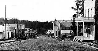
Tigerville or Tiger City (1878–1885) is a ghost town in the Black Hills of Pennington County, South Dakota, United States. The old mining town exemplifies the boom-and-bust fate of many Western towns.

Flatiron, formerly known as Yellow Creek or Flat Iron City, is a ghost town in Lawrence County, South Dakota, United States. It was known for its highly successful gold mining.

Maitland, originally called Garden City and sometimes misspelled Midland, is a ghost town in Lawrence County, South Dakota, United States. It was a mining community that boomed during the Black Hills Gold Rush, but was abandoned by about 1915.

Myers City, today called Myersville, is a ghost town in Pennington County, South Dakota, United States.

Roubaix, formerly known as Perry or Lewisville, is an unincorporated community in Lawrence County, South Dakota, United States. It is not monitored by the U.S. Census Bureau.

Nahant or West Nahant is a ghost town in Lawrence County, South Dakota, United States. It flourished as a logging and, to a lesser extent, mining town in the late 19th and early 20th centuries.

Sheridan, originally called Golden City, was an early mining camp in Pennington County, South Dakota, United States. It was the first county seat of Pennington County, from 1877 to 1878. It is now submerged under Sheridan Lake.

Galena is an unincorporated community in Lawrence County, South Dakota, United States. It is often considered to be a ghost town, even though a few families still live in the area. It is not tracked by the U.S. Census Bureau.

<span class="mw-page-title-main">Terraville, South Dakota</span> Ghost town in South Dakota, United States of America

Terraville is a ghost town in Lawrence County, South Dakota, United States. It was founded in 1877 as a mining camp and later evolved into a town. It was purchased by the Homestake Mining Company and was destroyed in 1982 to make way for a new mine.

The Cripple Creek Gold Rush was a period of gold production in the Cripple Creek area from the late 1800s until the early 1900s. Mining exchanges were in Cripple Creek, Colorado Springs, Pueblo and Victor. Smelting was in Gillett, Florence, and (Old) Colorado City. Mining communities sprang up quickly, but most lasted only as long as gold continued to be produced. Settlements included:

<span class="mw-page-title-main">Mystic, South Dakota</span> Unincorporated community in South Dakota, U.S.

Mystic is an unincorporated community in Pennington County, in the U.S. state of South Dakota. It began as a placer mining encampment called Sitting Bull in 1876, later attracting multiple railroads to the area. Its population began to decline in the early 20th century and it is now essentially a ghost town. The old townsite was added to the National Register of Historic Places in 1986.

Redfern is the site of an old Black Hills Gold Rush community. The area is located at the eastern base of Redfern Mountain, 6,076 feet in elevation, in Pennington County, South Dakota. The mountain and the Redfern townsite is located on the gravel road to Mystic, South Dakota, and is about a mile from the old town site of Tigerville. The Mystic Road is approximately miles from Hill City on the Deerfield Road.

<span class="mw-page-title-main">Chinatown, Deadwood, South Dakota</span>

Chinatown was a historic ethnic enclave in Deadwood, located in Lawrence County in the U.S. state of South Dakota. It became the largest Chinatown of any city east of San Francisco at the time. Notable figures of Deadwood's Chinatown include Fee Lee Wong, who made his way to the Black Hills during the 1870s for the Gold Rush. There are many cultural and economic differences that made the Chinese community distinct such as success with laundry establishments and the structure of Chinese families. The Chinese community is no longer there like it was at the end of the 19th century. Archeological excavations have tried to document and identify Deadwood's Chinatown artifacts and structures, in order to gain a better idea of what that occurred in these areas. These efforts will help better understand what the lives of Chinese members in South Dakota was like.

References

  1. 1 2 3 "Rochford". Geographic Names Information System . United States Geological Survey, United States Department of the Interior. February 13, 1980. Retrieved September 27, 2013.
  2. 1 2 3 4 5 6 7 Parker, Watson; Lambert, Hugh K. (1974). Black Hills Ghost Towns (1st ed.). Chicago, IL: The Swallow Press. pp. 164–165.
  3. Federal Writers' Project (1940). South Dakota place-names, v.1-3. University of South Dakota. p. 59.
  4. 1 2 3 4 5 Wolle, Muriel Sibell (1966) [1953]. The Bonanza Trail: Ghost Towns and Mining Camps of the West (5th ed.). Bloomington, Indiana: Indiana University Press. pp. 447–448.
  5. 1 2 3 4 5 6 7 Klock, Irma H. (1975). Yesterday's Gold Camps and Mines in the Northern Black Hills (1st ed.). Lead, SD: Seaton Publishing Company. pp. 12–15.
  6. 1 2 "Rochford." South Dakota Road Trip: Black Hills, Badlands & Lakes. Black Hills Badlands & Lake Association, n.d. Web. 27 Sept. 2013.
  7. "Hill City, SD Monthly Weather Forecast - weather.com". The Weather Channel. Retrieved April 24, 2020.
  8. "Rochford 2 WNW, South Dakota 1991-2020 Monthly Normals" . Retrieved August 10, 2023.
  9. "xmACIS". National Oceanic and Atmospheric Administration. Retrieved December 15, 2023.
  10. "Climate Statistics for Rochford, SD" . Retrieved September 28, 2013.