Related Research Articles

Sidney is a city in and the county seat of Cheyenne County, Nebraska, United States. The city is nine miles (14 km) north of the Colorado state line. The population was 6,757 at the 2010 census.

Deadwood is a city that serves as county seat of Lawrence County, South Dakota, United States. It was named by early settlers after the dead trees found in its gulch. The city had its heyday from 1876 to 1879, after gold deposits had been discovered there, leading to the Black Hills Gold Rush. At its height, the city had a population of 25,000, attracting Old West figures such as Wyatt Earp, Calamity Jane, and Wild Bill Hickok.
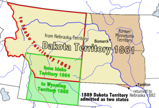
The Territory of Dakota was an organized incorporated territory of the United States that existed from March 2, 1861, until November 2, 1889, when the final extent of the reduced territory was split and admitted to the Union as the states of North Dakota and South Dakota.

Red Cloud was one of the most important leaders of the Oglala Lakota from 1868 to 1909. He was one of the most capable Native American opponents whom the United States Army faced in its invasion of the western territories. He defeated the United States during Red Cloud's War, which was a fight over control of the Powder River Country in northeastern Wyoming and southern Montana. The largest action of the war was the Fetterman Fight, with 81 US soldiers killed; it was the worst military defeat suffered by the US Army on the Great Plains until the Battle of the Little Bighorn 10 years later.

The Treaty of Fort Laramie is an agreement between the United States and the Oglala, Miniconjou, and Brulé bands of Lakota people, Yanktonai Dakota and Arapaho Nation, following the failure of the first Fort Laramie treaty, signed in 1851.

U.S. Route 385 (US 385) is a spur of U.S. Route 85 that runs for 1,206 miles (1,941 km) from Deadwood, South Dakota to Big Bend National Park in Texas.

The Great Sioux Reservation initially set aside land west of the Missouri River in South Dakota and Nebraska for the use of the Lakota Sioux, who had dominated this territory. The reservation was established in the Fort Laramie Treaty of 1868. It included all of present-day western South Dakota and modern Boyd County, Nebraska. This area was established by the United States as a reservation for the Teton Sioux, also known as the Lakota: the seven western bands of the "Seven Council Fires".
The Black Hills Gold Rush took place in Dakota Territory in the United States. It began in 1874 following the Custer Expedition and reached a peak in 1876–77.

Minnesela is a ghost town and was the first settlement in and county seat of Butte County, South Dakota, United States. Minnesela was founded in 1882 and was located three miles southeast of present-day Belle Fourche. The railroad's decision to bypass Minnesela and to continue on to Belle Fourche in 1890 caused the town to be abandoned by 1901.

The George S. Mickelson Trail is a rail trail in the Black Hills region of South Dakota.

The Red Cloud Agency was an Indian agency for the Oglala Lakota as well as the Northern Cheyenne and Arapaho, from 1871 to 1878. It was located at three different sites in Wyoming Territory and Nebraska before being moved to South Dakota. It was then renamed the Pine Ridge Reservation.
A private in the Fourth Infantry, Charles Howard served as photographer for the Stanton Expedition in 1877, traveling throughout eastern Wyoming, western Nebraska and into the Black Hills of Dakota Territory.
The Department of the Platte was a military administrative district established by the U.S. Army on March 5, 1866, with boundaries encompassing Iowa, Nebraska, Dakota Territory, Utah Territory and a small portion of Idaho. With headquarters in Omaha, the district commander oversaw the army's role initially along the Overland route to Salt Lake City, then later the construction route of the Union Pacific Railroad. The district also included the Montana road through eastern Wyoming. The district was discontinued when the Army's command was reorganized in 1898.

The Black Hills are a small and isolated mountain range rising from the Great Plains of North America in western South Dakota and extending into Wyoming, United States. Black Elk Peak, which rises to 7,244 feet (2,208 m), is the range's highest summit. The Black Hills encompass the Black Hills National Forest. The name "Black Hills" is a translation of the Lakota Pahá Sápa. The hills are so called because of their dark appearance from a distance, as they are covered in evergreen trees.

The Great Sioux War of 1876, also known as the Black Hills War, was a series of battles and negotiations that occurred in 1876 and 1877 in an alliance of Lakota Sioux and Northern Cheyenne against the United States. The cause of the war was the desire of the US government to obtain ownership of the Black Hills. Gold had been discovered in the Black Hills, settlers began to encroach onto Native American lands, and the Sioux and the Cheyenne refused to cede ownership. Traditionally, American military and historians place the Lakota at the center of the story, especially because of their numbers, but some Native Americans believe the Cheyenne were the primary target of the American campaign.

Four Mile is an unincorporated community in Custer County, South Dakota, United States, located four miles west of Custer at the junction of U.S. Route 16 and Pleasant Valley Road.
The Rapid City, Black Hills and Western Railroad, also known simply as the Black Hills and Western Railroad and commonly referred to as the Rapid Canyon Line or the Crouch Line, is a defunct standard gauge freight railroad line that operated in the Black Hills in the U.S. state of South Dakota. The railroad became known throughout the area for its crookedness and later became a tourist attraction. It ran from Rapid City to Mystic for a distance of 36.043 miles. The railroad ceased operations in 1947.

Deadwood Draw is part of the Sidney-Black Hills Trail near Sidney, Nebraska, which provided supplies for gold mining operations in the Black Hills from 1874 to 1881. The draw served as a staging area for freight wagons carrying supplies to the Black Hills and contains ruts caused by the wheels of the freight wagons and the animals that pulled them. The draw is listed on the National Register of Historic Places.
This timeline of South Dakota is a list of events in the history of South Dakota by year.
U.S. Route 385 (US 385) is a part of the United States Numbered Highway System that travels from Big Bend National Park in Texas to US 85 in Deadwood, South Dakota. Within the state of Nebraska, the highway is known as the Gold Rush Byway, one of nine scenic byways across the state. The highway follows along the old Sidney-Black Hills trail which played a crucial role during the Black Hills Gold Rush in the late 1870s. It served as the primary route to transport gold and mining gear between Sidney, Nebraska and the Black Hills to the north. Today, the highway enters Nebraska in the southeastern portion of the Nebraska Panhandle on the state line with Colorado northeast of Julesburg and continues in a northerly direction to the South Dakota state line north of Chadron.
References
- ↑ "The Sidney-Black Hills Trail". Nebraska State Historical Society. Archived from the original on August 20, 2004. Retrieved 5 April 2014.
{{cite web}}: CS1 maint: unfit URL (link) - ↑ "Sidney Black Hills Trail Summary". University of Nebraska. Retrieved 5 April 2014.