Ocean Township, Ocean County, New Jersey

Last updated

Ocean Township, New Jersey
2018-09-16 15 45 21 View north along New Jersey State Route 444 (Garden State Parkway) just south of Exit 69 in Ocean Township, Ocean County, New Jersey.jpg
The Garden State Parkway northbound in Ocean Township, Ocean County
Ocean Township Seal.jpg
Ocean twp nj 029.png
Location of Ocean Township in Ocean County highlighted in yellow (right). Inset map: Location of Ocean County in New Jersey highlighted in black (left).
Census Bureau map of Ocean Township, Ocean County, New Jersey.png
Census Bureau map of Ocean Township, Ocean County, New Jersey
Location map of Ocean County, New Jersey.svg
Red pog.svg
Ocean Township
Location in Ocean County
USA New Jersey relief location map.svg
Red pog.svg
Ocean Township
Location in New Jersey
Usa edcp relief location map.png
Red pog.svg
Ocean Township
Location in the United States
Coordinates: 39°47′27″N74°12′53″W / 39.790729°N 74.214609°W / 39.790729; -74.214609 [1] [2]
Country Flag of the United States.svg  United States
State Flag of New Jersey.svg  New Jersey
County Flag placeholder.svg Ocean
Incorporated April 13, 1876
Government
[3]
  Type Township
  BodyTownship Committee
   Mayor Lydia M. Dodd (R, term ends December 31, 2024) [4] [5]
   Administrator Diane B. Ambrosio [6]
   Municipal clerk Diane B. Ambrosio [7]
Area
[1]
  Total32.81 sq mi (84.97 km2)
  Land21.10 sq mi (54.65 km2)
  Water11.70 sq mi (30.31 km2)  35.67%
  Rank73rd of 565 in state
10th of 33 in county [1]
Elevation
[8]
59 ft (18 m)
Population
  Total8,835
  Estimate 
(2022) [9] [11]
9,001
  Rank268th of 565 in state
13th of 33 in county [12]
  Density423.4/sq mi (163.5/km2)
   Rank453rd of 565 in state
30th of 33 in county [12]
Time zone UTC−05:00 (Eastern (EST))
  Summer (DST) UTC−04:00 (Eastern (EDT))
ZIP Code
08758 – Waretown [13]
Area code(s) 609 exchanges: 242, 693, 971 [14]
FIPS code 3402954300 [1] [15] [16]
GNIS feature ID0882071 [1] [17]
Website www.twpoceannj.gov

Ocean Township is a township located on the Jersey Shore in Ocean County, in the U.S. state of New Jersey. As of the 2020 United States census, the township's population was 8,835, [9] [10] its largest ever decennial count and an increase of 503 (+6.0%) from the 2010 census count of 8,332, [18] [19] which in turn reflected an increase of 1,882 (+29.2%) from the 6,450 counted in the 2000 census. [20]

Contents

History

Ocean Township was incorporated as a township by an act of the New Jersey Legislature on April 13, 1876, from portions of both Lacey Township and Union Township (now Barnegat Township). Portions of the township were taken to create Long Beach Township (March 23, 1899) and Island Beach (June 23, 1933; dissolved in 1965 and absorbed into Berkeley Township). [21] The township derives its name from its seaside location. [22]

Even though Waretown constitutes only one incorporated community within Ocean Township, many people use "Waretown" to refer to all of Ocean Township. [23] [24] The local custom is so widespread that it surprises some new residents that the official name is Ocean Township. Non-residents have been known to confuse Ocean Township with the Ocean Township of Monmouth County. There was a petition drive in 2006 to get a name change to Township of Waretown on the ballot but it failed to obtain enough signatures. [25] The Waretown neighborhood is home to Albert Music Hall. [26]

The name Waretown is derived from Abraham Weair (1683–1768), who came to the area with a colony of Rogerine Baptists (Quaker Baptists) c.1737. When the colony left the area eleven years later, Weair, who had built a sawmill, stayed behind and became a prominent member of the community. [27]

During the American Revolutionary War, British ships sailed into the nearby Barnegat Inlet in an attempt to protect their New York-bound supply vessels from attacks by local privateers sailing schooners and whaleboats. Another British objective was to destroy Newlin's salt works, a local supplier of a crucial commodity to the Revolutionary army, needed for food preservation and gunpowder manufacture. [28] A massacre of local patriots occurred in October, 1782, when Captain John Bacon, loyal to the British crown, led a surprise attack on Long Beach. [28]

During the War of 1812, the British returned to Barnegat Inlet to blockade the Jersey coast. Local privateers were caught and their schooners burned. [28]

In the 1700s and 1800s, Waretown was a shipbuilding center. Vessels such as barques, barkentines, sloops, schooners, whaleboats and sneakboxes were constructed of white cedar native to the area. During this period, many sea captains built stately homes on bay front lots. [28]

Around the turn of the twentieth century, Waretown fishermen sold oysters, clams and scallops to dealers such as the Fulton Fish Market in New York City. Other local industries included charcoal production, cranberry farming and "mossing," or gathering sphagnum moss for sale to florists. Local hunters supplied New York and Philadelphia with wildfowl via the railroads. [28] Waretown became known for its hunting and fishing grounds, and celebrities like Presidents Grover Cleveland and William McKinley, baseball great Babe Ruth, and Wild West entertainer Buffalo Bill Cody came to participate in these pursuits. [29]

During World War II, blimps cruised along the Jersey coast looking for German U-boats. Local fishermen reported periscopes of U-boats within 20 miles of the shore. As a precaution, troops were stationed in town at the Bayview Hotel on Barnegat Bay. [30] In 1960, the landmark structure burned to the ground, nearly 70 years after its opening in 1890. [31]

Geography

According to the United States Census Bureau, the township had a total area of 32.81 square miles (84.97 km2), including 21.10 square miles (54.65 km2) of land and 11.70 square miles (30.31 km2) of water (35.67%). [1] [2]

Waretown (with a 2010 Census population of 1,569 [32] ) is an unincorporated community and census-designated place (CDP) located within Ocean Township. [33] [34] [35]

Other unincorporated communities, localities and place names located partially or completely within the township include Brookville, Wells Mills, Pebble Beach, Barnegat Beach, Holiday Beach, Sands Point Harbor, Skippers Cove, Bay Haven and Dogtown. [36]

The township borders the Ocean County municipalities of Barnegat Light, Barnegat Township, Berkeley Township, Lacey Township and Long Beach Township. [37] [38] [39]

The township is one of 56 South Jersey municipalities that are included within the New Jersey Pinelands National Reserve, a protected natural area of unique ecology covering 1,100,000 acres (450,000 ha), that has been classified as a United States Biosphere Reserve and established by Congress in 1978 as the nation's first National Reserve. [40] All of the township is included in either the state-designated Pinelands Area or the Pinelands National Reserve, which includes portions of Burlington County, along with areas in Atlantic, Camden, Cape May, Cumberland, Gloucester and Ocean counties. [41]

Demographics

Historical population
CensusPop.Note
1880 484
1890 482−0.4%
1900 436*−9.5%
1910 397−8.9%
1920 286−28.0%
1930 38735.3%
1940 427*10.3%
1950 52021.8%
1960 92177.1%
1970 2,222141.3%
1980 3,73167.9%
1990 5,41645.2%
2000 6,45019.1%
2010 8,33229.2%
2020 8,8356.0%
2022 (est.)9,001 [9] [11] 1.9%
Population sources: 1880–2000 [42]
1880–1920 [43] 1880–1890 [44]
1890–1910 [45] 1910–1930 [46]
1940–2000 [47] 2000 [48] [49]
2010 [18] [19] 2020 [9] [10]
* = Lost territory in previous decade. [21]

2010 census

The 2010 United States census counted 8,332 people, 3,483 households, and 2,557 families in the township. The population density was 405.3 inhabitants per square mile (156.5/km2). There were 4,291 housing units at an average density of 208.8 per square mile (80.6/km2). The racial makeup was 96.75% (8,061) White, 0.59% (49) Black or African American, 0.13% (11) Native American, 1.08% (90) Asian, 0.01% (1) Pacific Islander, 0.46% (38) from other races, and 0.98% (82) from two or more races. Hispanic or Latino of any race were 2.76% (230) of the population. [18]

Of the 3,483 households, 20.2% had children under the age of 18; 60.8% were married couples living together; 8.3% had a female householder with no husband present and 26.6% were non-families. Of all households, 20.9% were made up of individuals and 10.0% had someone living alone who was 65 years of age or older. The average household size was 2.39 and the average family size was 2.76. [18]

16.1% of the population were under the age of 18, 7.1% from 18 to 24, 20.0% from 25 to 44, 32.3% from 45 to 64, and 24.4% who were 65 years of age or older. The median age was 49.6 years. For every 100 females, the population had 98.7 males. For every 100 females ages 18 and older there were 96.7 males. [18]

The Census Bureau's 2006–2010 American Community Survey showed that (in 2010 inflation-adjusted dollars) median household income was $74,736 (with a margin of error of +/− $6,360) and the median family income was $75,815 (+/− $7,572). Males had a median income of $49,189 (+/− $9,450) versus $33,250 (+/− $10,524) for females. The per capita income for the borough was $36,895 (+/− $4,315). About 0.9% of families and 4.0% of the population were below the poverty line, including 4.2% of those under age 18 and 2.2% of those age 65 or over. [50]

2000 census

As of the 2000 United States census [15] there were 6,450 people, 2,446 households, and 1,743 families residing in the township. The population density was 310.1 inhabitants per square mile (119.7/km2). There were 2,981 housing units at an average density of 143.3 per square mile (55.3/km2). The racial makeup of the township was 97.33% White, 0.74% African American, 0.16% Native American, 0.42% Asian, 0.03% Pacific Islander, 0.36% from other races, and 0.96% from two or more races. Hispanic or Latino of any race were 3.10% of the population. [48] [49]

There were 2,446 households, out of which 33.4% had children under the age of 18 living with them, 57.5% were married couples living together, 9.6% had a female householder with no husband present, and 28.7% were non-families. 23.3% of all households were made up of individuals, and 10.1% had someone living alone who was 65 years of age or older. The average household size was 2.61 and the average family size was 3.08. [48] [49]

In the township the population was spread out, with 25.5% under the age of 18, 6.8% from 18 to 24, 30.3% from 25 to 44, 23.7% from 45 to 64, and 13.8% who were 65 years of age or older. The median age was 38 years. For every 100 females, there were 98.5 males. For every 100 females age 18 and over, there were 97.3 males. [48] [49]

The median income for a household in the township was $46,461, and the median income for a family was $55,379. Males had a median income of $39,149 versus $32,188 for females. The per capita income for the township was $22,830. About 5.6% of families and 7.8% of the population were below the poverty line, including 10.1% of those under age 18 and 4.6% of those age 65 or over. [48] [49]

Parks and recreation

Park facilities in Ocean Township include: [51]

Government

Local government

Ocean Township is governed under the Township form of New Jersey municipal government, one of 141 municipalities (of the 564) statewide that use this form, the second-most commonly used form of government in the state. [54] The Township Committee is comprised of three members, who are elected directly by the voters at-large in partisan elections to serve three-year terms of office on a staggered basis, with one seat coming up for election each year as part of the November general election in a three-year cycle. [3] [55] At an annual reorganization meeting, the Township Committee selects one of its members to serve as Mayor. [4] [56]

As of 2022, Township Committee members are Mayor Ben LoParo (R, term on committee and as mayor ends December 31, 2022), Deputy Mayor Kenneth Baulderstone (R, term on committee ends 2023; term as deputy mayor ends 2022) and Lydia Dodd (R, 2024). [4] [57] [58] [59] [60] [61] [62] [63]

In July 2009, local Republican party member and former Mayor Daniel Van Pelt was arrested by the Federal Bureau of Investigation as part of a statewide money laundering investigation. In May 2010, Van Pelt was convicted on federal corruption charges, and had been scheduled to be sentenced to federal prison on November 4, 2010. [64]

Federal, state, and county representation

Ocean Township is located in the 2nd Congressional District [65] and is part of New Jersey's 9th state legislative district. [66] [67] [68]

For the 118th United States Congress , New Jersey's 2nd congressional district is represented by Jeff Van Drew ( R , Dennis Township ). [69] New Jersey is represented in the United States Senate by Democrats Cory Booker ( Newark , term ends 2027) [70] and Bob Menendez ( Englewood Cliffs , term ends 2025). [71] [72]

For the 2024-2025 session , the 9th legislative district of the New Jersey Legislature is represented in the State Senate by Carmen Amato ( R , Lacey Township ) and in the General Assembly by Greg Myhre (R, Stafford Township ) and Brian E. Rumpf (R, Little Egg Harbor Township ). [73]

Ocean County is governed by a Board of County Commissioners comprised of five members who are elected on an at-large basis in partisan elections and serving staggered three-year terms of office, with either one or two seats coming up for election each year as part of the November general election. At an annual reorganization held in the beginning of January, the board chooses a director and a deputy director from among its members. [74] As of 2024, Ocean County's Commissioners (with party affiliation, term-end year and residence) are:

John P. Kelly (R, 2025, Eagleswood Township), [75] Virginia E. Haines (R, 2025, Toms River), [76] Director Barbara Jo Crea (R, 2024, Little Egg Harbor Township) [77] Deputy Director Gary Quinn (R, 2024, Lacey Township) [78] and Frank Sadeghi (R, 2026, Toms River). [79] [80] [81]

Constitutional officers elected on a countywide basis are: Clerk Scott M. Colabella (R, 2025, Barnegat Light), [82] [83] Sheriff Michael G. Mastronardy (R, 2025; Toms River) [84] [85] and Surrogate Jeffrey Moran (R, 2028, Beachwood). [86] [87] [88]

Politics

As of March 2011, there were a total of 6,245 registered voters in Ocean Township, of which 1,017 (16.3%) were registered as Democrats, 2,095 (33.5%) were registered as Republicans and 3,128 (50.1%) were registered as Unaffiliated. There were 5 voters registered as Libertarians or Greens. [89] Among the township's 2010 Census population, 75.0% (vs. 63.2% in Ocean County) were registered to vote, including 89.4% of those ages 18 and over (vs. 82.6% countywide). [89] [90]

In the 2012 presidential election, Republican Mitt Romney received 62.4% of the vote (2,881 cast), ahead of Democrat Barack Obama with 36.7% (1,693 votes), and other candidates with 0.9% (42 votes), among the 4,647 ballots cast by the township's 6,583 registered voters (31 ballots were spoiled), for a turnout of 70.6%. [91] [92] In the 2008 presidential election, Republican John McCain received 60.0% of the vote (2,654 cast), ahead of Democrat Barack Obama with 37.6% (1,665 votes) and other candidates with 1.4% (64 votes), among the 4,423 ballots cast by the township's 5,996 registered voters, for a turnout of 73.8%. [93] In the 2004 presidential election, Republican George W. Bush received 53.4% of the vote (506 ballots cast), outpolling Democrat John Kerry with 44.9% (425 votes) and other candidates with 0.7% (9 votes), among the 947 ballots cast by the township's 1,308 registered voters, for a turnout percentage of 72.4. [94]

In the 2013 gubernatorial election, Republican Chris Christie received 79.2% of the vote (2,577 cast), ahead of Democrat Barbara Buono with 19.4% (631 votes), and other candidates with 1.4% (45 votes), among the 3,307 ballots cast by the township's 6,555 registered voters (54 ballots were spoiled), for a turnout of 50.5%. [95] [96] In the 2009 gubernatorial election, Republican Chris Christie received 67.5% of the vote (2,274 ballots cast), ahead of Democrat Jon Corzine with 25.0% (841 votes), Independent Chris Daggett with 5.3% (178 votes) and other candidates with 1.1% (38 votes), among the 3,370 ballots cast by the township's 6,082 registered voters, yielding a 55.4% turnout. [97]

Education

For pre-kindergarten through sixth grade, public school students attend the Ocean Township School District. [98] As of the 2018–19 school year, the district, comprised of two schools, had an enrollment of 510 students and 53.6 classroom teachers (on an FTE basis), for a student–teacher ratio of 9.5:1. [99] Schools in the district (with 2018–19 enrollment data from the National Center for Education Statistics [100] ) are Waretown Elementary School [101] with an enrollment of 309 students in Pre-K to 3rd grade and Frederic A. Priff Elementary School [102] with 198 students in grades 4–6. [103] [104]

For seventh through twelfth grades, public school students attend the schools of the Southern Regional School District, which serves the five municipalities in the Long Beach Island Consolidated School DistrictBarnegat Light, Harvey Cedars, Long Beach Township, Ship Bottom and Surf City—along with students from Beach Haven and Stafford Township, together with the students from Ocean Township who attend as part of a sending/receiving relationship. [105] [106] Schools in the district (with 2018–19 enrollment data from the National Center for Education Statistics [107] ) are Southern Regional Middle School [108] with 934 students in grades 7–8 and Southern Regional High School [109] with 1,952 students in grades 9–12. [110] Both schools are in the Manahawkin section of Stafford Township.

Transportation

Roads and highways

As of May 2010, the township had a total of 58.12 miles (93.54 km) of roadways, of which 36.64 miles (58.97 km) were maintained by the municipality, 16.35 miles (26.31 km) by Ocean County and 2.95 miles (4.75 km) by the New Jersey Department of Transportation and 2.18 miles (3.51 km) by the New Jersey Turnpike Authority. [111]

The Garden State Parkway (accessible via Exit 69) and U.S. Route 9 both pass through the township, as does County Route 532. The Parkway connects Barnegat Township in the south to Lacey Township in the north [112] and includes interchange 69 for CR 532, which is signed for Waretown / Forked River. [113]

Public transportation

NJ Transit provides bus service to and from Atlantic City on the 559 bus route. [114]

Ocean Ride local service is provided on the Waretown Shoppers Loop route. [115] [116] [117]

Points of Interest

Notable people

People who were born in, residents of, or otherwise closely associated with Ocean Township include:

Related Research Articles

<span class="mw-page-title-main">Ocean County, New Jersey</span> County in New Jersey, United States

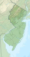
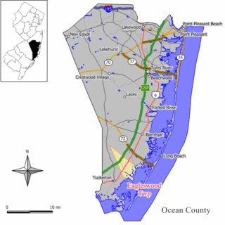
Ocean County is a county located along the Jersey Shore in the south-central portion of the U.S. state of New Jersey, and the southernmost county in the New York metropolitan area. The county borders the Atlantic Ocean on the east and in terms of total area is the state's largest county. Its county seat is Toms River. The county is part of the Jersey Shore region of the state.

<span class="mw-page-title-main">Barnegat Township, New Jersey</span> Township in Ocean County, New Jersey, United States

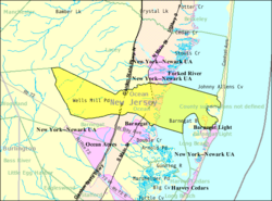
Barnegat Township is a township in Ocean County, in the U.S. state of New Jersey. As of the 2020 United States census, the township's population was 24,296, the highest ever count at a decennial census and an increase of 3,360 (+16.0%) from the 2010 census count of 20,936, which in turn reflected an increase of 5,666 (+37.1%) from the 15,270 counted in the 2000 census.

<span class="mw-page-title-main">Barnegat Light, New Jersey</span> Borough in Ocean County, New Jersey, United States

Barnegat Light is a borough in Ocean County, in the U.S. state of New Jersey. As of the 2020 United States census, the borough's population was 640, an increase of 66 (+11.5%) from the 2010 census count of 574, which in turn reflected a decline of 190 (−24.9%) from the 764 counted in the 2000 census. The borough borders the Atlantic Ocean on Long Beach Island and is home to Barnegat Lighthouse.

<span class="mw-page-title-main">Beach Haven, New Jersey</span> Borough in Ocean County, New Jersey, United States

Beach Haven is a borough situated on the Jersey Shore in southern Ocean County, in the U.S. state of New Jersey. The borough is located on Long Beach Island (LBI) and borders the Atlantic Ocean. As of the 2020 United States census, the borough's population was 1,027, a decrease of 143 (−12.2%) from the 2010 census count of 1,170, which in turn reflected a decline of 108 (−8.5%) from the 1,278 counted in the 2000 census.

<span class="mw-page-title-main">Berkeley Township, New Jersey</span> Township in Ocean County, New Jersey, United States

Berkeley Township is a township in Ocean County, in the U.S. state of New Jersey, extending from the Jersey Shore westward into the New Jersey Pine Barrens. As of the 2020 United States census, the township's population was 43,754, the highest ever in any decennial count and an increase of 2,499 (+6.1%) from the 2010 census count of 41,255, which in turn reflected an increase of 1,264 (+3.2%) from the 39,991 counted in the 2000 census.

<span class="mw-page-title-main">Eagleswood Township, New Jersey</span> Township in Ocean County, New Jersey, United States

Eagleswood Township is a township in Ocean County, in the U.S. state of New Jersey. As of the 2020 United States census, the township's population was 1,722, the highest recorded in any decennial count and an increase of 119 (+7.4%) from the 2010 census count of 1,603, which in turn reflected an increase of 162 (+11.2%) from the 1,441 counted in the 2000 census.

<span class="mw-page-title-main">Harvey Cedars, New Jersey</span> Borough in Ocean County, New Jersey, United States

Harvey Cedars is a coastal borough situated on the Jersey Shore, in southern Ocean County, in the U.S. state of New Jersey. The borough encompasses a narrow strip of Long Beach Island fronting both the Atlantic Ocean and Barnegat Bay. As of the 2020 United States census, the borough's population was 391, its highest decennial count ever and an increase of 54 (+16.0%) from the 2010 census count of 337, which in turn reflected a decline of 22 (−6.1%) from the 359 counted in the 2000 census.

<span class="mw-page-title-main">Lacey Township, New Jersey</span> Township in Ocean County, New Jersey, United States

Lacey Township is a township in Ocean County, in the U.S. state of New Jersey and is considered part of the Jersey Shore and South Jersey regions, as well as of the New York metropolitan area. As of the 2020 United States census, the township's population was 28,655, an increase of 1,011 (+3.7%) from the 2010 census count of 27,644, which in turn reflected an increase of 2,298 (+9.1%) from the 25,346 counted in the 2000 census. The 2010 population was the highest recorded in any decennial census. It was named for Continental Army General John Lacey.

<span class="mw-page-title-main">Lavallette, New Jersey</span> Borough in Ocean County, New Jersey, United States

Lavallette is a borough situated on the Jersey Shore, in Ocean County, in the U.S. state of New Jersey. As of the 2020 United States census, the borough's population was 1,787, a decrease of 88 (−4.7%) from the 2010 census count of 1,875, which in turn had reflected a decline of 790 (−29.6%) from the 2,665 counted in the 2000 census. Lavallette is situated on the Barnegat Peninsula, a long, narrow barrier peninsula that separates Barnegat Bay from the Atlantic Ocean.

<span class="mw-page-title-main">Little Egg Harbor Township, New Jersey</span> Township in Ocean County, New Jersey, US

Little Egg Harbor Township is a township situated on the Jersey Shore, within Ocean County, in the U.S. state of New Jersey. The township is the southernmost municipality in both Ocean County and the New York metropolitan area. As of the 2020 United States census, the township's population was 20,784, its highest decennial count ever and an increase of 719 (+3.6%) from the 2010 census count of 20,065, which in turn reflected an increase of 4,120 (+25.8%) from the 15,945 counted in the 2000 census.

<span class="mw-page-title-main">Long Beach Township, New Jersey</span> Township in Ocean County, New Jersey, United States

Long Beach Township is a Walsh Act Township situated on the Jersey Shore, in southeastern Ocean County, in the U.S. state of New Jersey. As of the 2020 United States census, the township's population was 3,153, an increase of 102 (+3.3%) from the 2010 census count of 3,051, which in turn reflected a decline of 278 (−8.4%) from the 3,329 counted in the 2000 census.

<span class="mw-page-title-main">Mantoloking, New Jersey</span> Borough in Ocean County, New Jersey, United States

Mantoloking is a coastal borough in Ocean County, in the U.S. state of New Jersey. As of the 2020 United States census, the borough's population was 331, an increase of 35 (+11.8%) from the 2010 census count of 296, which in turn reflected a decline of 127 (−30.0%) from the 423 counted in the 2000 census. The borough has an estimated summer population of approximately 5,000.

<span class="mw-page-title-main">Pine Beach, New Jersey</span> Borough in Ocean County, New Jersey, United States

Pine Beach is a borough in Ocean County, in the U.S. state of New Jersey. As of the 2020 United States census, the borough's population was 2,139, its highest ever decennial count and an increase of 12 (+0.6%) from the 2010 census count of 2,127, which in turn reflected an increase of 177 (+9.1%) from the 1,950 counted in the 2000 census.

<span class="mw-page-title-main">Ship Bottom, New Jersey</span> Borough in Ocean County, New Jersey, United States

Ship Bottom is a borough situated on the Jersey Shore, within Ocean County in the U.S. state of New Jersey. As of the 2020 United States census, the borough's population was 1,098, a decrease of 58 (−5.0%) from the 2010 census count of 1,156, which in turn had reflected a decline of 228 (−16.5%) from the 1,384 counted in the 2000 census. The borough is located on Long Beach Island and borders the Atlantic Ocean. The summer population can climb as high as 20,000.

<span class="mw-page-title-main">Stafford Township, New Jersey</span> Township in Ocean County, New Jersey, United States

Stafford Township is a township situated on the Jersey Shore in southern Ocean County, within the U.S. state of New Jersey. As of the 2020 United States census, the township's population was 28,617, its highest decennial count ever and an increase of 2,082 (+7.8%) from the 26,535 recorded at the 2010 census, which in turn reflected an increase of 4,003 (+17.8%) from the 22,532 counted in the 2000 census.

<span class="mw-page-title-main">Surf City, New Jersey</span> Borough in Ocean County, New Jersey, United States

Surf City is a borough situated on the Jersey Shore in southern Ocean County, within the U.S. state of New Jersey. As of the 2020 United States census, the borough's population was 1,243, an increase of 38 (+3.2%) from the 2010 census count of 1,205, which in turn had reflected a decline of 237 (−16.4%) from the 1,442 counted in the 2000 census. The borough borders the Atlantic Ocean on Long Beach Island.

<span class="mw-page-title-main">Tuckerton, New Jersey</span> Borough in Ocean County, New Jersey, United States

Tuckerton is a borough situated on the Jersey Shore, within Ocean County in the U.S. state of New Jersey. As of the 2020 United States census, the borough's population was 3,577, its highest decennial count ever and an increase of 230 (+6.9%) from the 3,347 recorded at the 2010 census, which in turn had reflected a decline of 170 (−4.8%) from the 3,517 counted in the 2000 census.

<span class="mw-page-title-main">Bass River Township, New Jersey</span> Township in Burlington County, New Jersey, United States

Bass River Township is a township at the southeastern tip of Burlington County, in the U.S. state of New Jersey. The township bears a shoreline fronting both the Bass River and the Great Bay. As of the 2020 United States census, the township's population was 1,355, a decrease of 88 (−6.1%) from the 2010 census count of 1,443, which in turn had reflected a decline of 67 (−4.4%) from the 1,510 counted in the 2000 census. The township and all of Burlington County is a part of the Philadelphia-Reading-Camden combined statistical area and the Delaware Valley. Bass River is the only municipality in Burlington County traversed by the Garden State Parkway.

The Ocean Township School District is a community public school district that serves students in pre-kindergarten through sixth grade from Ocean Township, in Ocean County, in the U.S. state of New Jersey.

The Beach Haven School District is a community public school district that serves students in pre-kindergarten through sixth grade from Beach Haven, in Ocean County, in the U.S. state of New Jersey.

References

  1. 1 2 3 4 5 6 2019 Census Gazetteer Files: New Jersey Places, United States Census Bureau. Accessed July 1, 2020.
  2. 1 2 US Gazetteer files: 2010, 2000, and 1990, United States Census Bureau. Accessed September 4, 2014.
  3. 1 2 2005 New Jersey Legislative District Data Book, Rutgers University Edward J. Bloustein School of Planning and Public Policy, April 2006, p. 49.
  4. 1 2 3 Township Committee, Township of Ocean. Accessed August 11, 2022. "Voters elect the township committee's three members. The elections are partisan and the committee members serve three-year staggered terms. The Township Committee elects the mayor for a one-year term."
  5. 2023 New Jersey Mayors Directory, New Jersey Department of Community Affairs, updated February 8, 2023. Accessed February 10, 2023.
  6. Administration, Township of Ocean. Accessed March 20, 2024.
  7. Township Clerk, Township of Ocean. Accessed August 11, 2022.
  8. U.S. Geological Survey Geographic Names Information System: Township of Ocean, Geographic Names Information System. Accessed March 8, 2013.
  9. 1 2 3 4 5 QuickFacts Ocean township, Ocean County, New Jersey, United States Census Bureau. Accessed May 5, 2023.
  10. 1 2 3 Total Population: Census 2010 - Census 2020 New Jersey Municipalities, New Jersey Department of Labor and Workforce Development. Accessed December 1, 2022.
  11. 1 2 Annual Estimates of the Resident Population for Minor Civil Divisions in New Jersey: April 1, 2020 to July 1, 2022, United States Census Bureau, released May 2023. Accessed May 18, 2023.
  12. 1 2 Population Density by County and Municipality: New Jersey, 2020 and 2021, New Jersey Department of Labor and Workforce Development. Accessed March 1, 2023.
  13. Look Up a ZIP Code for Waretown, NJ, United States Postal Service. Accessed December 30, 2012.
  14. Area Code Lookup - NPA NXX for Ocean, NJ, Area-Codes.com. Accessed September 8, 2014.
  15. 1 2 U.S. Census website, United States Census Bureau. Accessed September 4, 2014.
  16. Geographic Codes Lookup for New Jersey, Missouri Census Data Center. Accessed April 1, 2022.
  17. US Board on Geographic Names, United States Geological Survey. Accessed September 4, 2014.
  18. 1 2 3 4 5 DP-1 - Profile of General Population and Housing Characteristics: 2010 for Ocean township, Ocean County, New Jersey Archived 2020-02-12 at archive.today , United States Census Bureau. Accessed December 30, 2012.
  19. 1 2 Profile of General Demographic Characteristics: 2010 for Ocean township [ permanent dead link ], New Jersey Department of Labor and Workforce Development. Accessed December 30, 2012.
  20. Table 7. Population for the Counties and Municipalities in New Jersey: 1990, 2000 and 2010, New Jersey Department of Labor and Workforce Development, February 2011. Accessed May 1, 2023.
  21. 1 2 Snyder, John P. The Story of New Jersey's Civil Boundaries: 1606-1968, Bureau of Geology and Topography; Trenton, New Jersey; 1969. p. 204. Accessed October 23, 2012.
  22. Hutchinson, Viola L. The Origin of New Jersey Place Names, New Jersey Public Library Commission, May 1945. Accessed September 13, 2015.
  23. Riley, Michael. "Waretown: It's all in the name", Asbury Park Press , May 6, 2005. Accessed November 16, 2023. "Officially, the name of this community of 7,400 residents is Ocean Township.... People who arrive there from Exit 69 of the Garden State Parkway know the place as Waretown, which is what the original settlers called the village when they named it after their leader, whose name, incidentally, was Abraham Waier, not Abraham Ware."
  24. Staff. "Ocean mayor visits other Ocean", Asbury Park Press , November 21, 2006.
  25. "Waretown activist plans to try again.", Ocean County Observer, August 22, 2006.
  26. 1 2 Albert Music Hall, Ocean County, New Jersey. Accessed July 10, 2023.
  27. Fischer, William H. (1899). Biographical Cyclopaedia of Ocean County, New Jersey. Philadelphia, Pennsylvania: A. D. Smith & Company. pp. 31–32.
  28. 1 2 3 4 5 "Welcome to Ocean Township". Barnegat Branch Rail Trail Signs. Ocean County Cultural and Heritage Commission.{{cite web}}: Missing or empty |url= (help)
  29. Township of Ocean 2017 Calendar. Waretown, New Jersey: Township of Ocean in cooperation with Waretown Historical Society. 2017.
  30. Township of Ocean 2016 Calendar. Waretown, New Jersey: Township of Ocean in cooperation with Waretown Historical Society. 2016.
  31. Township of Ocean 2017 Calendar. Waretown, New Jersey: Township of Ocean in cooperation with Waretown Historical Society. 2017.
  32. DP-1 - Profile of General Population and Housing Characteristics: 2010 Demographic Profile Data for Waretown CDP, New Jersey Archived 2020-02-12 at archive.today , United States Census Bureau. Accessed December 30, 2012.
  33. GCT-PH1 - Population, Housing Units, Area, and Density: 2010 - County -- County Subdivision and Place from the 2010 Census Summary File 1 for Ocean County, New Jersey Archived 2020-02-12 at archive.today , United States Census Bureau. Accessed December 30, 2012.
  34. 2006-2010 American Community Survey Geography for New Jersey, United States Census Bureau. Accessed December 30, 2012.
  35. New Jersey: 2010 - Population and Housing Unit Counts - 2010 Census of Population and Housing (CPH-2-32), United States Census Bureau, August 2012. Accessed December 30, 2012.
  36. Barnegat Branch Trail, Trail Signs, Welcome to Ocean Township. Accessed May 31, 2018.
  37. Areas touching Ocean Township, MapIt. Accessed March 2, 2020.
  38. Ocean County Map Archived March 19, 2022, at the Wayback Machine , Coalition for a Healthy NJ. Accessed March 2, 2020.
  39. New Jersey Municipal Boundaries, New Jersey Department of Transportation. Accessed November 15, 2019.
  40. The Pinelands National Reserve, New Jersey Pinelands Commission. Accessed November 27, 2013.
  41. Pinelands Municipalities, New Jersey Pinelands Commission, April 2003. Accessed November 27, 2013.
  42. Barnett, Bob. Population Data for Ocean County Municipalities, 1850 - 2000, WestJersey.org, January 6, 2011. Accessed December 25, 2012.
  43. Compendium of censuses 1726-1905: together with the tabulated returns of 1905, New Jersey Department of State, 1906. Accessed July 29, 2013.
  44. Porter, Robert Percival. Preliminary Results as Contained in the Eleventh Census Bulletins: Volume III - 51 to 75, p. 99. United States Census Bureau, 1890. Accessed December 25, 2012.
  45. Thirteenth Census of the United States, 1910: Population by Counties and Minor Civil Divisions, 1910, 1900, 1890, United States Census Bureau, p. 338. Accessed December 25, 2012.
  46. Fifteenth Census of the United States : 1930 - Population Volume I, United States Census Bureau, p. 718. Accessed December 25, 2012.
  47. Table 6: New Jersey Resident Population by Municipality: 1940 - 2000, Workforce New Jersey Public Information Network, August 2001. Accessed May 1, 2023.
  48. 1 2 3 4 5 Census 2000 Profiles of Demographic / Social / Economic / Housing Characteristics for Ocean township, Ocean County, New Jersey Archived 2003-10-15 at the Wayback Machine , United States Census Bureau. Accessed December 30, 2012.
  49. 1 2 3 4 5 DP-1: Profile of General Demographic Characteristics: 2000 - Census 2000 Summary File 1 (SF 1) 100-Percent Data for Ocean township, Ocean County, New Jersey Archived 2020-02-12 at archive.today , United States Census Bureau. Accessed December 30, 2012.
  50. DP03: Selected Economic Characteristics from the 2006-2010 American Community Survey 5-Year Estimates for Ocean township, Ocean County, New Jersey Archived 2020-02-12 at archive.today , United States Census Bureau. Accessed December 30, 2012.
  51. Parks, Township of Ocean, Ocean County, New Jersey. Accessed March 2, 2020.
  52. Wells Mills County Park Trail Map, Ocean County, New Jersey. Accessed March 2, 2020.
  53. Barnegat Branch Trail, Ocean County, New Jersey Department of Planning. Accessed March 2, 2020.
  54. Inventory of Municipal Forms of Government in New Jersey, Rutgers University Center for Government Studies, July 1, 2011. Accessed June 1, 2023.
  55. "Forms of Municipal Government in New Jersey", p. 7. Rutgers University Center for Government Studies. Accessed June 1, 2023.
  56. Form of Government, Township of Ocean. Accessed August 11, 2022. "Voters Elect: Township Committee 3 or 5 members, elected at-large. Staggered, 3 year terms. Partisan; Organization Of Governing Bod: First week in January MAYOR Elected by Township Committee for 1 year term. Chairs Committee with voice and vote. Head of municipal government."
  57. 2022 Municipal Data Sheet, Township of Ocean. Accessed August 11, 2022.
  58. Township of Ocean, Ocean County, New Jersey. Accessed August 11, 2022.
  59. 2022 Ocean County & Municipal Elected Officials, Ocean County, New Jersey Clerk, updated April 1, 2022. Accessed May 1, 2022.
  60. 2021 General Election Official Results, Ocean County, New Jersey. Accessed January 1, 2022.
  61. 2020 General Election November 3, 2020 Official results, Ocean County, New Jersey, updated December 2, 2020. Accessed January 1, 2021.
  62. 2019 General Election Official Results November 5, 2019, Ocean County, New Jersey Clerk, updated November 15, 2019. Accessed January 1, 2020.
  63. 2018 General Election Official Results November 6, 2018, Ocean County, New Jersey Clerk, updated November 19, 2018. Accessed January 1, 2019.
  64. Spoto, MaryAnn. "Ex-N.J. Assemblyman Daniel Van Pelt is convicted of taking $10K bribe", The Star-Ledger , May 19, 2010. Accessed July 29, 2013. "Van Pelt, a former Ocean Township mayor and committeeman, brings to 19 the number of people who have been convicted or pleaded guilty in the investigation."
  65. 2022 Redistricting Plan, New Jersey Redistricting Commission, December 8, 2022.
  66. Municipalities Sorted by 2011-2020 Legislative District, New Jersey Department of State. Accessed February 1, 2020.
  67. 2019 New Jersey Citizen's Guide to Government, New Jersey League of Women Voters. Accessed October 30, 2019.
  68. Districts by Number for 2011-2020, New Jersey Legislature. Accessed January 6, 2013.
  69. Directory of Representatives: New Jersey, United States House of Representatives. Accessed January 3, 2019.
  70. U.S. Sen. Cory Booker cruises past Republican challenger Rik Mehta in New Jersey, PhillyVoice. Accessed April 30, 2021. "He now owns a home and lives in Newark's Central Ward community."
  71. Biography of Bob Menendez, United States Senate, January 26, 2015. "Menendez, who started his political career in Union City, moved in September from Paramus to one of Harrison's new apartment buildings near the town's PATH station.."
  72. Home, sweet home: Bob Menendez back in Hudson County. nj.com. Accessed April 30, 2021. "Booker, Cory A. - (D - NJ) Class II; Menendez, Robert - (D - NJ) Class I"
  73. Legislative Roster for District 9, New Jersey Legislature. Accessed January 9, 2024.
  74. Freeholder to Commissioner History, Ocean County, New Jersey. Accessed June 1, 2022.
  75. Commissioner John P. Kelly, Ocean County, New Jersey. Accessed June 1, 2022.
  76. Commissioner Director Virginia E. Haines, Ocean County, New Jersey. Accessed June 1, 2022.
  77. Commissioner Barbara Jo Crea, Ocean County, New Jersey. Accessed June 1, 2022.
  78. Commissioner Gary Quinn, Ocean County, New Jersey. Accessed June 1, 2022.
  79. Commissioner Joseph H. Vicari, Ocean County, New Jersey. Accessed June 1, 2022.
  80. Meet our Commissioners, Ocean County, New Jersey. Accessed June 1, 2022.
  81. County Directory, Ocean County, New Jersey. Accessed June 1, 2022.
  82. County Clerk, Ocean County, New Jersey. Accessed June 1, 2022.
  83. Clerks, Constitutional Officers Association of New Jersey. Accessed June 1, 2022.
  84. County Sheriff Michael G. Mastronardy, Ocean County, New Jersey. Accessed June 1, 2022.
  85. Sheriffs, Constitutional Officers Association of New Jersey. Accessed June 1, 2022.
  86. County Surrogate Jeffrey W. Moran, Ocean County, New Jersey. Accessed June 1, 2022.
  87. Surrogates, Constitutional Officers Association of New Jersey. Accessed June 1, 2022.
  88. 2022 Ocean County and Municipal Elected Officials, Ocean County, New Jersey. Accessed June 1, 2022.
  89. 1 2 Voter Registration Summary - Ocean, New Jersey Department of State Division of Elections, March 23, 2011. Accessed December 30, 2012.
  90. GCT-P7: Selected Age Groups: 2010 - State -- County Subdivision; 2010 Census Summary File 1 for New Jersey Archived 2020-02-12 at archive.today , United States Census Bureau. Accessed December 30, 2012.
  91. "Presidential General Election Results - November 6, 2012 - Ocean County" (PDF). New Jersey Department of Elections. March 15, 2013. Retrieved December 24, 2014.
  92. "Number of Registered Voters and Ballots Cast - November 6, 2012 - General Election Results - Ocean County" (PDF). New Jersey Department of Elections. March 15, 2013. Retrieved December 24, 2014.
  93. 2008 Presidential General Election Results: Ocean County, New Jersey Department of State Division of Elections, December 23, 2008. Accessed December 30, 2012.
  94. 2004 Presidential Election: Ocean County, New Jersey Department of State Division of Elections, December 13, 2004. Accessed December 30, 2012.
  95. "Governor - Ocean County" (PDF). New Jersey Department of Elections. January 29, 2014. Retrieved December 24, 2014.
  96. "Number of Registered Voters and Ballots Cast - November 5, 2013 - General Election Results - Ocean County" (PDF). New Jersey Department of Elections. January 29, 2014. Retrieved December 24, 2014.
  97. 2009 Governor: Ocean County Archived 2012-10-17 at the Wayback Machine , New Jersey Department of State Division of Elections, December 31, 2009. Accessed December 30, 2012.
  98. Public Schools Directory 2019-2020; Living & Learning in Ocean County, Ocean County, New Jersey. Accessed June 9, 2020.
  99. District information for Ocean Township School District, National Center for Education Statistics. Accessed April 1, 2020.
  100. School Data for the Ocean Township School District, National Center for Education Statistics. Accessed April 1, 2020.
  101. Waretown Elementary School, Ocean Township School District. Accessed June 9, 2020.
  102. Frederic A. Priff Elementary School Archived October 30, 2020, at the Wayback Machine , Ocean Township School District. Accessed June 9, 2020.
  103. Schools, Ocean Township School District. Accessed June 9, 2020.
  104. New Jersey School Directory for the Ocean Township School District, New Jersey Department of Education. December 29, 2016.
  105. Southern Regional High School 2015 Report Card Narrative, New Jersey Department of Education. Accessed June 2, 2016. "Located in Manahawkin, the Southern Regional School District draws from the constituent districts of Long Beach Township, Beach Haven, Surf City, Ship Bottom, Barnegat Light, Harvey Cedars and Stafford Township, as well as the tuition sending district of Ocean Township (Waretown).
  106. About Us, Southern Regional School District. Accessed March 2, 2020. "Our school is a 7-12 comprehensive regional high school district. Our middle school covers grades 7-8 and our high school covers grades 9-12. The district comprises the constituent members of Stafford Township, Beach Haven, Long Beach Township, (which includes the municipalities of Loveladies, North Beach, High Bar Harbor and Brant Beach and Long Beach Township), Barnegat Light, Harvey Cedars, Ship Bottom, and Surf City. Waretown is our sending district."
  107. School Data for the Southern Regional School District, National Center for Education Statistics. Accessed April 1, 2020.
  108. Southern Regional Middle School, Southern Regional School District. Accessed January 20, 2020.
  109. Southern Regional High School, Southern Regional School District. Accessed January 20, 2020.
  110. New Jersey School Directory for the Southern Regional School District, New Jersey Department of Education. Accessed December 29, 2016.
  111. Ocean County Mileage by Municipality and Jurisdiction, New Jersey Department of Transportation, May 2010. Accessed July 18, 2014.
  112. Garden State Parkway Straight Line Diagram, New Jersey Department of Transportation, January 1997. Accessed September 8, 2014.
  113. Travel Resources: Interchanges, Service Areas & Commuter Lots, New Jersey Turnpike Authority. Accessed September 8, 2014.
  114. Ocean County Bus / Rail Connections, NJ Transit, backed up by the Internet Archive as of July 26, 2010. Accessed December 30, 2012.
  115. Ocean County Bus Service Archived 2015-08-14 at the Wayback Machine , Greater Mercer TMA. Accessed August 11, 2015.
  116. Ocean Ride Rider's Guide Archived 2015-06-27 at the Wayback Machine , Ocean County, New Jersey. Accessed August 11, 2015.
  117. Ocean County Transit Guide Archived 2015-09-23 at the Wayback Machine , Ocean County, New Jersey. Accessed August 11, 2015.
  118. O'Reilly, David (December 23, 2016). "'Grand Ol' Opry' of the Pinelands marks 20 years". The Inquirer, Philadelphia, Pennsylvania. Retrieved June 2, 2018.
  119. PCS/Albert Music Hall Chronological Fact Sheet, Albert Music Hall. Accessed March 2, 2020.
  120. About Us, Lighthouse Center for Natural Resource Education. Accessed March 2, 2020.
  121. Reddington, Linda (May 2017). "Places of Interest". Welcome to Our Neck of the Woods: Your Guide to Barnegat, Lacey, Stafford and Waretown, the Times-Beacon Newspapers: 35.
  122. Reddington, Linda (May 2017). "Places of Interest". Welcome to Our Neck of the Woods: Your Guide to Barnegat, Lacey, Stafford and Waretown, the Times-Beacon Newspapers: 38.
  123. Historical Society, Township of Ocean, Ocean County, New Jersey. Accessed March 2, 2020.
  124. Kenneth G. Miller Archived 2013-12-02 at the Wayback Machine , Rutgers University Department of Earth and Planetary Sciences. Accessed November 27, 2013. "A resident of Pennington, NJ, Ken grew up in Medford, NJ in the heart of the pine barrens and still owns a house in Waretown, NJ, the home of the sounds of the NJ pines, where he watches the inexorable rise in sea level from his deck 16 ft above Barnegat Bay."
  125. Staff. "NJ man's discovery lands Nobel Prize" Archived 2013-12-03 at the Wayback Machine , WPVI-TV, October 6, 2009. Accessed November 27, 2013. "George E. Smith, 79, holds a display with a photograph of the first video telephone and some early CCD chips at his home in Waretown, N.J., Tuesday, Oct. 6, 2009, after it was announced that he had won the Nobel Prize in physics."
  126. Spoto, MaryAnn. "Corruption trial opens for former N.J. Assemblyman Daniel Van Pelt", NJ Advance Media for NJ.com, May 5, 2010. Accessed September 13, 2015. "Van Pelt, a former mayor and committeeman of Ocean Township in Ocean County, is accused of accepting a $10,000 bribe from Dwek, who was posing as fictitious developer David Esenbach, to speed along the permitting process for a development project in Van Pelt's Shore community."
  127. Galante, Meredith. "South Korean man draws on his experience of immigrating to Jersey as basis for award-winning book and his coming to terms with his cultural differences", The Star-Ledger , January 7, 2011. Accessed September 13, 2015. "Woo could only count to 10 in English before arriving. To him, life on West Park Avenue in Ocean Township looked a lot like where he lived in Doug Kyo Doug neighborhood about 20 miles from downtown Seoul: the suburbs."