Toms River (CDP), New Jersey

Last updated

Toms River, New Jersey
Ocean County Courthouse.jpg
The Ocean County Courthouse in Toms River was built in 1851.
Toms river cdp nj 029.png
Map of Toms River CDP in Ocean County. Inset: Location of Ocean County in New Jersey.
Location map of Ocean County, New Jersey.svg
Red pog.svg
Toms River
Location in Ocean County
USA New Jersey relief location map.svg
Red pog.svg
Toms River
Location in New Jersey
Usa edcp relief location map.png
Red pog.svg
Toms River
Location in the United States
Coordinates: 39°59′41″N74°11′16″W / 39.994856°N 74.187754°W / 39.994856; -74.187754
Country Flag of the United States.svg  United States
State Flag of New Jersey.svg  New Jersey
County Ocean
Township Toms River
Area
[1]
  Total40.54 sq mi (105.00 km2)
  Land39.00 sq mi (101.00 km2)
  Water1.54 sq mi (4.00 km2)  4.40%
Elevation
[2]
62 ft (19 m)
Population
 (2020) [3]
  Total92,830
  Density2,380.7/sq mi (919.2/km2)
Time zone UTC−05:00 (Eastern (EST))
  Summer (DST) UTC−04:00 (Eastern (EDT))
ZIP Codes
08753-08757 [4]
Area code(s) 732/848
FIPS code 34-73110 [5] [6] [7]
GNIS feature ID02390394 [5] [8] [9]

Toms River is an unincorporated community and census-designated place (CDP) [10] located within and constituting the mainland portion of Toms River Township (formerly Dover Township), in Ocean County, in the U.S. state of New Jersey. [11] [12] [13] [14] As of the 2020 United States census, the CDP's population was 92,830, [3] its highest decennial count ever and an increase of 4,039 (+4.5%) from the 88,791 recorded at the 2010 census, [15] which in turn reflected an increase of 2,464 (+2.9%) from the 86,327 counted in the 2000 census. The Toms River CDP is the county seat of Ocean County. [16] The area is named for Toms River, whose estuary flows through the community and empties into Barnegat Bay.

Contents

Toms River Township and its fully contained census-designated place are not co-extensive. In addition to the census-designated place, which includes all of mainland Toms River Township and is home to the vast majority of the township's population, Toms River Township includes two small CDPs: Dover Beaches North (2020 Census population of 1,277) and Dover Beaches South (1,331), both of which are located on the Barnegat Peninsula. As defined by the Census Bureau based on 2010 Census data, more than 96% of Toms River Township's area and of its population of 95,438 was located in Toms River CDP. [17]

Geography

According to the United States Census Bureau, the CDP had a total area of 40.738 square miles (105.510 km2), including 38.947 square miles (100.871 km2) of land and 1.791 square miles (4.639 km2) of water (4.40%). [5] [18]

Demographics

Historical population
CensusPop.Note
1950 2,517
1960 6,062140.8%
1970 7,30320.5%
1980 7,4652.2%
1990 7,5240.8%
2000 86,3271,047.4%
2010 88,7912.9%
2020 92,8304.5%
Population sources: 1950 [19]
1960-1970 [20] 1960-1980 [21] 1990-2010 [13]
2000 [22] 2010 [15] 2020 [3]

2010 census

The 2010 United States census counted 88,791 people, 33,394 households, and 23,643 families in the CDP. The population density was 2,279.8 per square mile (880.2/km2). There were 36,605 housing units at an average density of 939.9 per square mile (362.9/km2). The racial makeup was 89.71% (79,653) White, 2.77% (2,459) Black or African American, 0.17% (151) Native American, 3.67% (3,260) Asian, 0.02% (17) Pacific Islander, 1.98% (1,760) from other races, and 1.68% (1,491) from two or more races. Hispanic or Latino of any race were 8.04% (7,136) of the population. [15]

Of the 33,394 households, 29.0% had children under the age of 18; 54.9% were married couples living together; 11.9% had a female householder with no husband present and 29.2% were non-families. Of all households, 24.3% were made up of individuals and 11.7% had someone living alone who was 65 years of age or older. The average household size was 2.62 and the average family size was 3.12. [15]

21.7% of the population were under the age of 18, 8.0% from 18 to 24, 24.1% from 25 to 44, 29.5% from 45 to 64, and 16.7% who were 65 years of age or older. The median age was 42.5 years. For every 100 females, the population had 92.4 males. For every 100 females ages 18 and older there were 89.6 males. [15]

2000 census

As of the 2000 United States census [6] there were 86,327 people, 31,674 households, and 23,470 families living in the CDP. The population density was 846.6/km2 (2,192.7/mi2). There were 34,375 housing units at an average density of 337.1/km2 (873.1/mi2). The racial makeup of the CDP was 93.36% White, 1.81% African American, 0.13% Native American, 2.54% Asian, 0.02% Pacific Islander, 0.98% from other races, and 1.15% from two or more races. Hispanic or Latino of any race were 4.65% of the population. [22]

There were 31,674 households, out of which 32.3% had children under the living with them, 60.1% were married couples living together, 10.7% had a female householder with no husband present, and 25.9% were non-families. 21.5% of all households were made up of individuals, and 10.4% had someone living alone who was 65 years of age or older. The average household size was 2.66 and the average family size was 3.11. [22]

In the CDP the population was spread out, with 23.8% under the age of 18, 7.3% from 18 to 24, 27.4% from 25 to 44, 24.8% from 45 to 64, and 16.6% who were 65 years of age or older. The median age was 40 years. For every 100 females, there were 92.7 males. For every 100 females age 18 and over, there were 89.0 males. [22]

The median income for a household in the CDP was $55,659, and the median income for a family was $62,971. Males had a median income of $47,448 versus $30,763 for females. The per capita income for the CDP was $24,831. 5.6% of the population and 4.0% of families were below the poverty line. 6.6% of those under the age of 18 and 6.2% of those 65 and older were living below the poverty line. [22]

Related Research Articles

<span class="mw-page-title-main">Twin Rivers, New Jersey</span> Populated place in Mercer County, New Jersey, US

Twin Rivers is an unincorporated community and census-designated place (CDP) situated within East Windsor Township, in Mercer County, in the U.S. state of New Jersey. As of the 2020 United States census, Twin Rivers' population was 7,787 its highest decennial count ever and an increase of 344 (+4.6%) from the 7,443 recorded at the 2010 census, which in turn reflected an increase of 21 (+0.3%) from the 7,422 counted in the 2000 census. Twin Rivers was the first planned unit development in New Jersey.

<span class="mw-page-title-main">Brownville, New Jersey</span> Populated place in Middlesex County, New Jersey, US

Brownville is an unincorporated community and census-designated place (CDP) located within Old Bridge Township, in Middlesex County, in the U.S. state of New Jersey. As of the 2010 United States Census, the CDP's population was 2,383.

<span class="mw-page-title-main">Concordia, New Jersey</span> Populated place in Middlesex County, New Jersey, US

Concordia is an unincorporated community and census-designated place (CDP) located within Monroe Township, in Middlesex County, in the U.S. state of New Jersey. The CDP is oriented around the age restricted gated community of Concordia. As of the 2010 United States Census, the CDP's population was 3,092.

<span class="mw-page-title-main">Cranbury (CDP), New Jersey</span> Populated place in Middlesex County, New Jersey, US

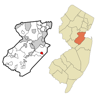
Cranbury is an unincorporated community and census-designated place (CDP) located within Cranbury Township, in Middlesex County, in the U.S. state of New Jersey. As of the 2010 United States Census, the CDP's population was 2,181. Despite the similarity in the name of Cranbury Township and the CDP, the two are not one and the same, as had been the case for most paired Township / CDP combinations prior to the 2010 Census, in which the CDP was coextensive with a township of the same name.

<span class="mw-page-title-main">Madison Park, New Jersey</span> Populated place in Middlesex County, New Jersey, US

Madison Park is an unincorporated community and census-designated place (CDP) located within Old Bridge Township, in Middlesex County, in the U.S. state of New Jersey. As of the 2010 United States Census, the CDP's population was 7,144. The name "Madison Park" reflects Old Bridge's original name of "Madison Township" which it had when it was formed on March 2, 1869 from portions of South Amboy Township, until November 5, 1975, when voters approved a referendum changing the township's name to Old Bridge Township.

<span class="mw-page-title-main">Old Bridge (CDP), New Jersey</span> Populated place in Middlesex County, New Jersey, US

Old Bridge is a census-designated place (CDP) located in Old Bridge Township, in Middlesex County, in the U.S. state of New Jersey. As of the 2010 United States Census, the CDP's population was 23,753. Despite the similarity in the name of the CDP and the township, the two are not one and the same, as had been the case for most paired Township / CDP combinations prior to the 2010 Census, in which the CDP was coextensive with a township of the same name.

<span class="mw-page-title-main">Princeton Meadows, New Jersey</span> Populated place in Middlesex County, New Jersey, US

Princeton Meadows is an unincorporated community and census-designated place (CDP) located within Plainsboro Township, in Middlesex County, in the U.S. state of New Jersey. As of the 2010 United States Census, the CDP's population was 13,834.

<span class="mw-page-title-main">Society Hill, Middlesex County, New Jersey</span> Populated place in Middlesex County, New Jersey, US

Society Hill is an unincorporated community and census-designated place (CDP) located within Piscataway Township, in Middlesex County, in the U.S. state of New Jersey. As of the 2010 United States Census, the CDP's population was 3,829.

<span class="mw-page-title-main">Whittingham, New Jersey</span> Populated place in Middlesex County, New Jersey, US

Whittingham, also known as Greenbriar at Whittingham, is an unincorporated community and census-designated place (CDP) located within Monroe Township, in Middlesex County, in the U.S. state of New Jersey. As of the 2010 United States Census, the CDP's population was 2,476. The area is focused around the age-restricted gated community of Whittingham.

<span class="mw-page-title-main">Morganville, New Jersey</span> Populated place in Monmouth County, New Jersey, US

Morganville is an unincorporated community and census-designated place (CDP) within Marlboro Township, in Monmouth County, New Jersey. As of the 2010 United States Census, the CDP's population was 5,040.

<span class="mw-page-title-main">Shark River Hills, New Jersey</span> Populated place in Monmouth County, New Jersey, US

Shark River Hills is an unincorporated community and census-designated place (CDP) within Neptune Township, in Monmouth County, in the U.S. state of New Jersey. As of the 2010 United States Census, the CDP's population was 3,697.

<span class="mw-page-title-main">Cedar Glen Lakes, New Jersey</span> Populated place in Ocean County, New Jersey, US

Cedar Glen Lakes is an unincorporated community and census-designated place (CDP) located within Manchester Township, in Ocean County, in the U.S. state of New Jersey. As of the 2010 United States Census, the CDP's population was 1,421.

<span class="mw-page-title-main">Cedar Glen West, New Jersey</span> Populated place in Ocean County, New Jersey, US

Cedar Glen West is an unincorporated community and census-designated place (CDP) located within Manchester Township, in Ocean County, in the U.S. state of New Jersey. As of the 2010 United States Census, the CDP's population was 1,267.

<span class="mw-page-title-main">Holiday City South, New Jersey</span> Populated place in Ocean County, New Jersey, US

Holiday City South is an unincorporated community and census-designated place (CDP) located within Berkeley Township, in Ocean County, in the U.S. state of New Jersey. As of the 2010 United States Census, the CDP's population was 3,689.

<span class="mw-page-title-main">Leisure Village East, New Jersey</span> Populated place in Ocean County, New Jersey, US

Leisure Village East is an unincorporated community and census-designated place (CDP) located within Lakewood Township, in Ocean County, in the U.S. state of New Jersey. As of the 2010 United States Census, the CDP's population was 4,217. Leisure Village East is one of several active adult communities bearing similar names. Leisure Village and Leisure Village West are the other two communities nearby.

<span class="mw-page-title-main">Silver Ridge, New Jersey</span> Populated place in Ocean County, New Jersey, US

Silver Ridge is an unincorporated community and census-designated place (CDP) located within Berkeley Township, in Ocean County, in the U.S. state of New Jersey. As of the 2010 United States Census, the CDP's population was 1,133.

<span class="mw-page-title-main">Vista Center, New Jersey</span> Populated place in Ocean County, New Jersey, US

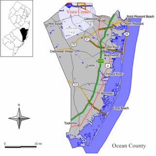
Vista Center is an unincorporated community and census-designated place (CDP) located within Jackson Township in Ocean County, in the U.S. state of New Jersey. As of the 2010 United States Census, the CDP's population was 3,689.

<span class="mw-page-title-main">Crandon Lakes, New Jersey</span> Populated place in Sussex County, New Jersey, US

Crandon Lakes is an unincorporated community and census-designated place (CDP) split between Hampton Township and Stillwater Township, in Sussex County, in the U.S. state of New Jersey. As of the 2010 United States Census, the CDP's population was 1,178, of which 682 were in Hampton Township and 496 in Stillwater Township.

<span class="mw-page-title-main">Ramtown, New Jersey</span> Populated place in Monmouth County, New Jersey, US

Ramtown is a census-designated place and unincorporated community located within Howell Township, in Monmouth County, in the U.S. state of New Jersey. As of the 2010 United States Census, the CDP's population was 6,242.

<span class="mw-page-title-main">Alloway (CDP), New Jersey</span> Populated place in Salem County, New Jersey, US

Alloway is an unincorporated community and census-designated place (CDP) located within Alloway Township, in Salem County, in the U.S. state of New Jersey. As of the 2010 United States Census, the CDP's population was 1,402.

References

  1. "ArcGIS REST Services Directory". United States Census Bureau. Retrieved October 11, 2022.
  2. U.S. Geological Survey Geographic Names Information System: Toms River Census Designated Place, Geographic Names Information System. Accessed January 11, 2013.
  3. 1 2 3 QuickFacts Toms River CDP, New Jersey, United States Census Bureau. Accessed February 26, 2023.
  4. Look Up a ZIP Code for Toms River, NJ, United States Postal Service. Accessed February 15, 2012.
  5. 1 2 3 Gazetteer of New Jersey Places, United States Census Bureau. Accessed July 21, 2016.
  6. 1 2 U.S. Census website, United States Census Bureau. Accessed September 4, 2014.
  7. Geographic Codes Lookup for New Jersey, Missouri Census Data Center. Accessed June 9, 2023.
  8. US Board on Geographic Names, United States Geological Survey. Accessed September 4, 2014.
  9. Geographic Codes Lookup for New Jersey, Missouri Census Data Center. Accessed April 1, 2022.
  10. State of New Jersey Census Designated Places - BVP20 - Data as of January 1, 2020, United States Census Bureau. Accessed December 1, 2022.
  11. GCT-PH1 - Population, Housing Units, Area, and Density: 2010 - County -- County Subdivision and Place from the 2010 Census Summary File 1 for Ocean County, New Jersey Archived 2020-02-12 at archive.today , United States Census Bureau. Accessed January 11, 2013.
  12. 2006-2010 American Community Survey Geography for New Jersey, United States Census Bureau. Accessed January 11, 2013.
  13. 1 2 New Jersey: 2010 - Population and Housing Unit Counts - 2010 Census of Population and Housing (CPH-2-32), United States Census Bureau, August 2012. Accessed January 11, 2013.
  14. Locality Search, State of New Jersey. Accessed April 19, 2015.
  15. 1 2 3 4 5 DP-1 - Profile of General Population and Housing Characteristics: 2010 Demographic Profile Data for Toms River CDP, New Jersey Archived 2020-02-12 at archive.today , United States Census Bureau. Accessed January 12, 2013.
  16. "Find a County". National Association of Counties. Retrieved June 7, 2011.
  17. Census Designated Places 2020 Census P.L. 94-171 Redistricting Data, New Jersey Department of Labor and Workforce Development. Accessed February 26, 2023.
  18. US Gazetteer files: 2010, 2000, and 1990, United States Census Bureau. Accessed September 4, 2014.
  19. Staff. A Report of the Seventeenth Decennial Census of the United States - Census of Population: 1950; Volume I - Number of Inhabitants, p. 30-11. Accessed January 12, 2013.
  20. Staff. 1970 Census of Population: Volume I - Characteristics of the Population; Part I - United States Summary Section 1, United States Census Bureau, June 1973. Accessed January 12, 2013.
  21. Staff. 1980 Census of Population: Number of Inhabitants United States Summary, p. 1-141. United States Census Bureau, June 1983. Accessed January 12, 2012.
  22. 1 2 3 4 5 DP-1 - Profile of General Demographic Characteristics: 2000 from the Census 2000 Summary File 1 (SF 1) 100-Percent Data for Toms River CDP, New Jersey Archived 2020-02-12 at archive.today , United States Census Bureau. Accessed January 12, 2013.