
Port Augusta is a small city in South Australia. Formerly a seaport, it is now a road traffic and railway junction city mainly located on the east coast of the Spencer Gulf immediately south of the gulf's head and about 322 kilometres (200 mi) north of the state capital, Adelaide. The suburb of Port Augusta West is located on the west side of the gulf on the Eyre Peninsula. Other major industries included, up until the mid-2010s, electricity generation. At June 2018, the estimated urban population was 13,799, having declined at an average annual rate of -0.53% over the preceding five years.
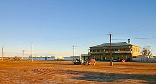
Marree is a small town located in the north of South Australia. It lies 589 kilometres (366 mi) North of Adelaide at the junction of the Oodnadatta Track and the Birdsville Track, 49 metres (161 ft) above sea level. Marree is an important service centre for the large sheep and cattle stations in northeast South Australia as well as a stopover destination for tourists traveling along the Birdsville or Oodnadatta Tracks.
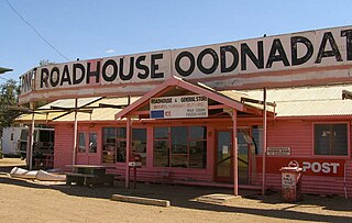
Oodnadatta is a small, remote outback town and locality in the Australian state of South Australia, located about 873 kilometres (542 mi) north of the state capital of Adelaide and 112 m above sea level.

Coonawarra is a small town north of Penola in South Australia. It is best known for the Coonawarra wine region named after it.

Buckleboo is a locality in the Australian state of South Australia on the Eyre Peninsula located about 313 kilometres (194 mi) northwest of the state capital of Adelaide and about 31 kilometres (19 mi) northwest of the municipal seat of Kimba.
Glendambo is a town and locality in the Australian state of South Australia located on the Stuart Highway about 592 kilometres (368 mi) from the state capital of Adelaide and about 254 kilometres (158 mi) from Coober Pedy.
Marla is a town and locality in the Australian state of South Australia located in the state's north-west about 970 kilometres (600 mi) north-west of the state capital of Adelaide and about 402 kilometres (250 mi) south of the town of Alice Springs in the Northern Territory.

Parachilna is a country town in South Australia. The town was first surveyed in 1863 due to its closeness to a government water well. It is on the railway line and road between Port Augusta and Leigh Creek. Today, the Prairie Hotel, railway station, airstrip and a few buildings remain. The road east into the Flinders Ranges leads through Parachilna Gorge, recognised for its scenic beauty, to Blinman. The town is surrounded by Motpena station pastoral lease.

Blinman is a locality incorporating two towns located in the Australian state of South Australia within the Flinders Ranges about 425 kilometres (264 mi) north of the state capital of Adelaide. It is very small but has the claim of being the highest surveyed town in South Australia. It serves as a base for large acre pastoralists and tourism. The town is just north of the Flinders Ranges National Park, is 60 kilometres north of Wilpena Pound.

Yalata is an Aboriginal community located 200 kilometres (120 mi) west of Ceduna and 140 km (87 mi) south of Ooldea on the edge of the Nullarbor Plain in South Australia. It lies on the traditional lands of the Wirangu people, but the settlement began as Yalata Mission in the early 1950s when Pila Nguru people were moved from Ooldea Mission when that closed, after previously being moved from their land in the Great Victoria Desert owing to nuclear testing by the British Government.
Kingoonya, historically spelt Kingoonyah, is a small almost totally abandoned farming settlement in the central outback of the Australian state of South Australia. It was established in the early 1900s as a railway support town for the 200 or so sheep farming families on the train-line extending west across the Nullarbor Plain to Western Australia. It played a significant role in the construction of the Trans-Australian Railway.

Yunta is a town and locality in the Australian state of South Australia located in the state's east about 275 kilometres (171 mi) north-east of the state capital of Adelaide. It is a service centre supporting both the local area and travellers passing through on the Barrier Highway. It lies south west of Broken Hill and north east of Peterborough.

Penong is a town and locality on the Nullarbor Plain, in the far west of the state of South Australia located about 616 kilometres (383 mi) north-west of the state capital of Adelaide. With no settlements between it and Border Village on the border with Western Australia, 400 km (250 mi) away on the Eyre Highway, it is a popular rest-stop for travellers.
Coorabie is a town and locality in the Australian state of South Australia located about 675 kilometres (419 mi) north-west of the state capital of Adelaide. It is outside of district council boundaries, and therefore managed by the Outback Communities Authority. It is located in the west of South Australia, and includes the Wahgunyah Conservation Park. The Eyre Highway passes through the locality, although the Coorabie township is south of the highway.

Mannahill is a town and locality in the Australian state of South Australia. Mannahill is in the Northeast Pastoral district and is one of the easternmost settlements in South Australia.
Yarrah is a rural locality in the Far North region of South Australia. The eastern section of Yarrah lies within the Flinders Ranges Council, while the western section lies in the Pastoral Unincorporated Area.

Flinders Chase is a locality in the Australian state of South Australia located on the south-western coast of Kangaroo Island overlooking the body of water known in Australia as the Southern Ocean and by international authorities as the Great Australian Bight. It is located about 210 kilometres south-west of the state capital of Adelaide.
Emeroo is a locality in the Australian state of South Australia about 295 kilometres north of the state capital of Adelaide and about 18 kilometres northeast of Port Augusta in the state’s Far North region.

Flinders Ranges is a locality in the Australian state of South Australia located in the mountain range of the same name, about 380 km (240 mi) north of the state capital of Adelaide, about 86 km (53 mi) north-east of the municipal seat of Quorn and about 131 km (81 mi) north-east of the centre of Port Augusta in the state's Far North region.
Bookabie is a town and locality in the Australian state of South Australia located on the state’s west coast overlooking the Great Australian Bight about 648 kilometres north-west of the state capital of Adelaide and about 103 kilometres west of the town centre of Ceduna.

