
Biggin Hill is a settlement on the south-eastern outskirts of Greater London, England, within the London Borough of Bromley. Within the boundaries of the historic county of Kent, prior to 1965 it was also in the administrative county of Kent. It is situated beyond London's urban sprawl, 15.2 miles (24.5 km) south-southeast of Charing Cross, with Keston to the north, New Addington to the north-west and Tatsfield, in the neighbouring county of Surrey, to the south. At the 2011 Census, Biggin Hill had a population of 9,951.

Keston is a village in Greater London, England, located within the London Borough of Bromley, Greater London. Prior to 1965 it was within the historic county of Kent. It is part suburban, part rural in nature and lies on the edge of Hayes Common, just beyond the London conurbation to the south of Bromley Common. It includes the small hamlet of Nash to the southwest. The northern, more suburban part of Keston is sometimes referred to as Keston Mark.
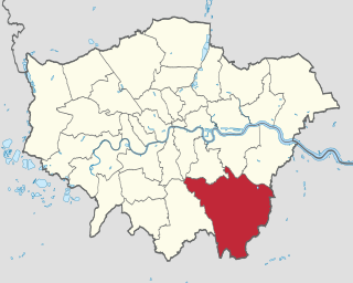
The London Borough of Bromley is the southeasternmost of the London boroughs that make up Greater London, bordering the ceremonial county of Kent, which most of Bromley was part of before 1965. The borough's population is an estimated 332,336. It is named after Bromley, its principal town; other major towns are Penge, Hayes, West Wickham, Chislehurst, Beckenham and Orpington. The local authority is Bromley London Borough Council.

London Biggin Hill Airport is an international airport at Biggin Hill in the London Borough of Bromley, located 12 NM south-southeast of Central London. The airport was formerly a Royal Air Force station RAF Biggin Hill, and a small enclave on the airport still retains that designation.

Downe, formerly Down, is a village in Greater London, England, located within the London Borough of Bromley but beyond the London urban sprawl. Downe is 3.4 miles (5.5 km) south west of Orpington and 14.2 miles (22.9 km) south east of Charing Cross. Downe lies on a hill, and much of the centre of the village is unchanged; the former village school now acts as the village hall. The word Downe originates from the Anglo Saxon word dūn, latterly down, hence the South and North Downs. In April 1965, Downe and the remaining part of Orpington Urban District Council, was abolished, and transferred from the historic county of Kent and placed within the newly created London Borough of Bromley.
Westerham is a town and civil parish in the Sevenoaks District of Kent, England. It is located 3.4 miles east of Oxted and 6 miles west of Sevenoaks, adjacent to the Kent border with both Greater London and Surrey. It is recorded as early as the 9th century, and was mentioned in the Domesday Book in a Norman form, Oistreham. Hām is Old English for a village or homestead, and so Westerham means a westerly homestead. The River Darent flows through the town, and formerly powered three watermills.

Orpington is a constituency created in 1945 and represented in the House of Commons of the UK Parliament since 2019 by Gareth Bacon, a Conservative. It is the largest constituency in Greater London by area, covering the east and south of the London Borough of Bromley.

Elgood's is a family-owned regional brewery in Wisbech, Cambridgeshire, England, which was established in 1795.

Wrexham Lager is a lager brewed in Wrexham, north-east Wales, tracing its heritage to 1881. After the original brewery's closure in 2000, the brand was revived by the Roberts family in 2011 using an older recipe.
The Greater London Built-up Area, or Greater London Urban Area, is a conurbation in south-east England that constitutes the continuous urban sprawl of London, and includes surrounding adjacent urban towns as defined by the Office for National Statistics. It is the largest urban area in the United Kingdom with a population of 9,787,426 in 2011.

Green Street Green is an area in south-east London, located in the London Borough of Bromley and, prior to 1965, in the historic county of Kent. It is located south of Orpington, west of Chelsfield, north-west of Pratt's Bottom, north of Hazelwood, and south east of Farnborough.

Stalisfield is a village in the borough of Swale in Kent, England, located on a secondary road about 1½ miles (2.4 km) north of Charing and 5 miles south west of Faversham. The parish includes the hamlet of Stalisfield Green.
Transportation needs within the county of Kent in South East England has been served by both historical and current transport systems.

Burton upon Trent has a long history of brewing, at one time exporting beer throughout the world and accounting for a quarter of UK beer production; emulation of Burton water in brewing is called Burtonisation. Much of the town was given over to the industry throughout the 19th century and brewers dominated it politically and socially.

The Ringlestone Inn is an historic public house and restaurant, located in the Ringlestone hamlet near the village of Wormshill in Kent, England. Dating back to the reign of Henry VIII (1509–1547) the current Grade II listed building was constructed in 1533 and retains its original brick and flint walls and oak beams. The interior is unchanged since around 1732 and includes tables crafted from the timbers of an 18th-century Thames barge. An inscription on an ancient oak sideboard formerly found at the property reads: A Ryghte Joyouse and welcome greetynge too ye all, it is now located at Knole as it is inscribed with the names John Tufton, Earl of Thanet and Margaret Sackville of Knole.
Berry's Green a small hamlet in the London Borough of Bromley in Greater London, UK. It is a fairly wooded rural area with a scattering of farmland. Housing consists mainly of detached properties, mostly bungalows, with a row of local authority cottages and a static mobile home site. It is part of the largest ward in Greater London, Darwin (ward), which covers a very rural area, including Downe, Cudham, Leaves Green, Single Street, Luxted, and Westerham Hill.
The lost village of Werps was one of a group of small settlements which later became collectively known as Jackfield in the Broseley Parish in Shropshire. The Werps lay on the south side of the river Severn, opposite the Old Coalport China Works and records indicate either three or four public houses, although it is unclear as to whether any of their names are renames of the same building or whether re-built on the same site.
The Southern Heights Light Railway (SHLR) was to have been a speculative London area suburban electric railway between Orpington, Kent and Sanderstead, Surrey. It was authorised in 1928 under the Light Railways Act 1896, but ultimately not constructed. The engineer was to have been Colonel Holman Fred Stephens, heavily involved in the promotion of light railways.

Fremlin's was a brewery in Maidstone, Kent, England. It was established by Ralph Fremlin in 1861, who eschewed the pub trade and focused on bottled beer, on religious grounds. The beer was known for the distinctive elephant logo on the bottles. The brewery expanded to become the largest in Kent, before going into decline after being purchased by Whitbread in 1967.


