
A pub is a drinking establishment licensed to serve alcoholic drinks for consumption on the premises. The term first appeared in the late 17th century, and was used to differentiate private houses from those which were open to the public as alehouses, taverns and inns. Today, there is no strict definition, but CAMRA states a pub has four characteristics:
- is open to the public without membership or residency
- serves draught beer or cider without requiring food be consumed
- has at least one indoor area not laid out for meals
- allows drinks to be bought at a bar
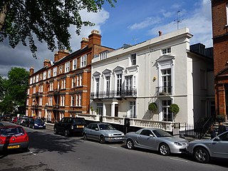
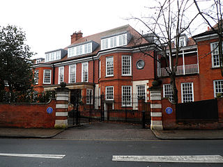
Hampstead is an area in London, England, which lies four miles northwest of Charing Cross, and extends from the A5 road to Hampstead Heath, a large, hilly expanse of parkland. The area forms the northwest part of the London Borough of Camden, a borough in Inner London which for the purposes of the London Plan is designated as part of Central London.
Hendon is an urban area in the Borough of Barnet, northwest London 7 miles (11 km) northwest of Charing Cross. Hendon was an ancient manor and parish in the county of Middlesex and a former borough, the Municipal Borough of Hendon; it has been part of Greater London since 1965. Hendon falls almost entirely within the NW4 postcode, while the West Hendon part falls in NW9. Colindale to the northwest was once considered part of Hendon but is today separated by the M1 motorway.

Kilburn is an area of north west London, England, which spans the boundary of three London Boroughs: Camden to the east, City of Westminster, and Brent to the west. There is also an area in the City of Westminster known locally as “Mozart” that along with Queens Park and Kensal Green are known as West Kilburn, which sometimes is treated as a distinct locality. Kilburn High Road railway station lies 3.5 miles (5.6 km) north-west of Charing Cross.
Winchmore Hill is a suburb and electoral ward in the Borough of Enfield, North London, in the N21 postal district. With the Winchmore Hill conservation area as a focal point, the district is bounded on the east by Green Lanes, Barrowell Green, Firs Lane and Fords Grove, and on the north-west by Grovelands Park; in the south it extends to part of Aldermans Hill, and in the north to Vicars Moor Lane and Houndsden Road. Winchmore Hill is 8.9 miles (14.3 km) north north-east of Charing Cross.

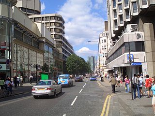
Shepherd's Bush is a district of West London, England, within the London Borough of Hammersmith and Fulham 4.9 miles (7.9 km) west of Charing Cross, and identified as a major metropolitan centre in the London Plan.

West Hampstead is a London Underground station in West Hampstead. It is located on West End Lane between Broadhurst Gardens and Blackburn Road and is situated in Travelcard Zone 2. It is on the Jubilee line between Kilburn and Finchley Road stations. It is 100 m (110 yd) from West Hampstead station on the London Overground North London line and 200 m (220 yd) from West Hampstead Thameslink station. Metropolitan line trains also pass through the station, but do not usually stop.

St. John's Wood is a London Underground station located in St John's Wood in the City of Westminster, north-west London. It was opened in 1939 as a stop on the Bakerloo line. Today St. John's Wood is served by the Jubilee line, between Swiss Cottage and Baker Street stations and is in Travelcard Zone 2. Essentially, St. John's Wood station is a local station with the nearby Metropolitan Line bypassing this station. A journey between St. John's Wood and Baker Street typically takes less than three minutes.

Belsize Park is a London Underground station in Belsize Park, north-west London. It is on the Edgware branch of the Northern line, between Hampstead and Chalk Farm stations, and is in fare zone 2. It stands at the northern end of Haverstock Hill. In July 2011 it became a Grade II listed building.

Gospel Oak is an inner urban area of north west London in the London Borough of Camden at the very south of Hampstead Heath. The neighbourhood is positioned between Hampstead to the north-west, Dartmouth Park to the north-east, Kentish Town to the south-east, and Belsize Park to the south-west. Gospel Oak lies across the NW5 and NW3 postcodes and is served by Gospel Oak station on the London Overground. The North London Suburb, Gospel Oak, has many schools around it.

Hampstead is a London Underground station in Hampstead, North London, England. It is on the Edgware branch of the Northern line, between Golders Green and Belsize Park stations. The branch's northernmost subterranean station, it is on the boundary between Travelcard Zone 2 and Zone 3.

Golders Green is a London Underground station in Golders Green, north London. The station is on the Edgware branch of the Northern line between Brent Cross and Hampstead stations. It is in Travelcard Zone 3 and is the first surface station on the Edgware branch when heading north.

The World's End is a pub and music venue at 174 Camden High Street in Camden Town, London, England, just south of Camden Town tube station with an additional branch at Finsbury Park, 23 Stroud Green Rd, London. It is a long established business, formerly known as Mother Red Cap or Mother Damnable's.

Leslie William Green was an English architect. He is best known for his design of iconic stations constructed on the London Underground railway system in central London during the first decade of the 20th century, with distinctive oxblood red faïence blocks including pillars and semi-circular first-floor windows, and patterned tiled interiors done in the Modern Style.

The Charing Cross, Euston and Hampstead Railway (CCE&HR), also known as the Hampstead Tube, was a railway company established in 1891 that constructed a deep-level underground "tube" railway in London. Construction of the CCE&HR was delayed for more than a decade while funding was sought. In 1900 it became a subsidiary of the Underground Electric Railways Company of London (UERL), controlled by American financier Charles Yerkes. The UERL quickly raised the funds, mainly from foreign investors. Various routes were planned, but a number of these were rejected by Parliament. Plans for tunnels under Hampstead Heath were authorised, despite opposition by many local residents who believed they would damage the ecology of the Heath.

North End is a never-completed underground station, on the Charing Cross, Euston and Hampstead Railway. The station was to have been built at North End on the boundaries of Hampstead Heath and Golders Hill Park and is located on the Edgware branch between Hampstead and Golders Green.
The A400 road is an A road in London that runs from Charing Cross to Archway in North London. It passes some of London's most famous landmarks.
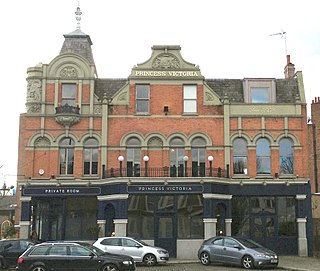
The Princess Victoria is a public house and former gin palace on the Uxbridge Road, Shepherd's Bush, London W12. First opened in 1829, it closed in June 2017 when its parent company, Affinity Bars and Restaurants, became insolvent, but re-opened in November 2017 under new operators Three Cheers Pub Company.
North End Way is a street in Hampstead in the London Borough of Camden, today a stretch of the A502 road. At the boundary with the London Borough of Barnet it becomes North End Road running northwards into Golders Green where it terminates at the junction with Finchley Road, by the tube station. North End Way passes through Hampstead Heath.

North End is located on the northern edge of Hampstead, just south of Golders Green. For much of its existence it was a rural hamlet but is now part of suburban London. Hampstead Heath lies both east and west of the settlement, while Hampstead Garden Suburb is to its northeast connected by Hampstead Way. It sits on the border between the London Borough of Camden and the London Borough of Barnet. North End Way connects it with Hampstead Village.

