Paddington is an area in the City of Westminster, in central London, England. A medieval parish then a metropolitan borough, it was integrated with Westminster and Greater London in 1965. Paddington station, designed by the engineer Isambard Kingdom Brunel opened in 1847. It is also the site of St Mary's Hospital and the former Paddington Green Police Station.

Maida Vale is a London Underground station in Maida Vale in inner north-west London. The station is on the Bakerloo line, between Kilburn Park and Warwick Avenue stations, and is in Travelcard Zone 2.
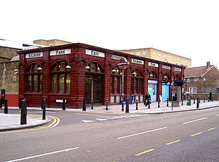
Kilburn Park is a London Underground station at Kilburn in the London Borough of Brent. The station is on the Bakerloo line, between Queen's Park and Maida Vale stations, and is in Travelcard Zone 2.

Maida Vale is an affluent residential district consisting of the northern part of Paddington in West London, west of St John's Wood and south of Kilburn. It is also the name of its main road, on the continuous Edgware Road. Maida Vale is part of the City of Westminster, 3.1 miles (5.0 km) north-west of Charing Cross. It has many late Victorian and Edwardian blocks of mansion flats. The area is home to the BBC Maida Vale Studios.

Edward Jeffrey Irving Ardizzone,, who sometimes signed his work "DIZ", was a British painter, printmaker and war artist, and the author and illustrator of books, many of them for children. For Tim All Alone, which he wrote and illustrated, Ardizzone won the inaugural Kate Greenaway Medal from the Library Association for the year's best children's book illustration by a British subject. For the 50th anniversary of the Medal in 2005, the book was named one of the top ten winning titles, selected by a panel to compose the ballot for public election of an all-time favourite.
Sutton Valence is a village about five miles (8 km) SE of Maidstone, Kent, England on the A274 road going south to Headcorn and Tenterden. It is on the Greensand Ridge overlooking the Vale of Kent and Weald. St Mary's Church is on the west side of the village on Chart Road, close to the junction of the High Street with the A274. Another landmark is Sutton Valence Castle on the east side of the village, of which only the ruins of the 12th-century keep remain, under the ownership of English Heritage.

Westminster City Council is the local authority for the City of Westminster in Greater London, England. The city is divided into 20 wards, each electing three councillors. The council is currently composed of 31 Labour Party members and 23 Conservative Party members. The council was created by the London Government Act 1963 and replaced three local authorities: Paddington Metropolitan Borough Council, St Marylebone Metropolitan Borough Council and Westminster Borough Council.
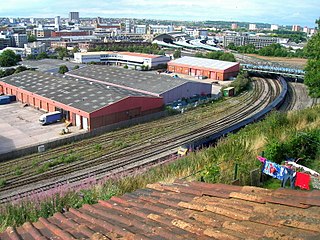
Totterdown is an inner-suburb of Bristol, England, situated just south of the River Avon and to the south-east of Temple Meads railway station and the city centre.

Richmond Green is a recreation area near the centre of Richmond, a town of about 20,000 inhabitants situated in south-west London. Owned by the Crown Estate, it is leased to the London Borough of Richmond upon Thames. The Green, which has been described as "one of the most beautiful urban greens surviving anywhere in England", is roughly square in shape and its open grassland, framed with broadleaf trees, extends to roughly twelve acres. On the north-east side there is also a smaller open space called Little Green. Richmond Green and Little Green are overlooked by a mixture of period townhouses, historic buildings and municipal and commercial establishments including the Richmond Lending Library and Richmond Theatre.

Newbold Comyn is a park on the Eastern edge of Leamington Spa, Warwickshire, England.

Maida Vale Studios is a complex of seven BBC sound studios, of which five are in regular use, in Delaware Road, Maida Vale, west London.
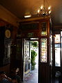
Crocker's Folly is a Grade II* listed public house at 24 Aberdeen Place, St John's Wood, London. It was built in 1898, in a Northern Renaissance style, and was previously called The Crown. Geoff Brandwood and Jane Jephcote's guide to heritage pubs in London describes it as "a truly magnificent pub-cum-hotel" with "superb fittings", including extensive use of marble. The architect was Charles Worley.
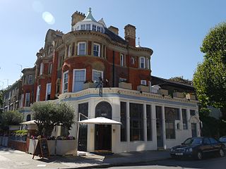
The Prince Alfred is a grade II* listed public house at 5a Formosa Street, Maida Vale, London, W9. It was first listed as grade II in 1970, and upgraded to grade II* in June 2022 for its lavish interior.

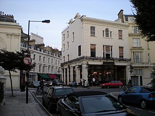
The Warrington is a Grade II listed public house at Warrington Crescent, Maida Vale, London W9 1EH.

The Carlton Tavern is a pub in Kilburn, London, originally completed in 1921, that was illegally demolished in 2015 by Tel Aviv-based developer CLTX, which had failed to obtain the necessary planning permission. The Westminster City Council subsequently ordered the pub to be rebuilt. It reopened on 12 April 2021. The pub was the only building in the street to survive the Blitz during World War II.
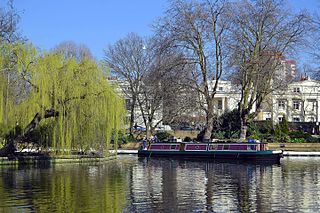
Little Venice is an affluent residential district in West London, England, around the junction of the Paddington Arm of the Grand Union Canal, the Regent's Canal, and the entrance to Paddington Basin. The junction forms a triangular shape basin. Many of the buildings in the vicinity are Regency white painted stucco terraced town houses and taller blocks (mansions) in the same style. The area is 2.5 miles (4.0 km) west-north-west of Charing Cross and immediately north-west of Paddington.

The Windsor Castle is a former public house on Harrow Road, Maida Vale, London. It was a seminal rock venue throughout the 1960s and 1970s, with notable early performances from The Rolling Stones, The Who and U2. Despite now being derelict, the building is a designated heritage asset.

Hamilton Terrace is a wide, tree-lined residential thoroughfare in St John's Wood, London, England. It runs north to south from Carlton Hill to St. John's Wood Road, and is parallel to Maida Vale to the west.
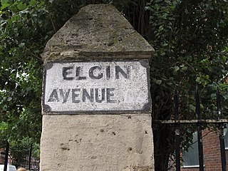
Elgin Avenue is a street in Maida Vale in London. Located in the City of Westminster, it runs east to west from the A5 road close to Maida Vale tube station west to the Maida Hill area where it meets the Harrow Road. Sutherland Avenue runs roughly parallel to the south and is connected to Elgin Avenue by Lauderdale Road. The road continues east of the A5 as Abercorn Place which runs through St. John's Wood.