Orwell, New York

Last updated

Orwell, New York
Oswego County New York incorporated and unincorporated areas Orwell highlighted.svg
Location in Oswego County and the state of New York.
Coordinates: 43°33′30″N75°57′3″W / 43.55833°N 75.95083°W / 43.55833; -75.95083
Country United States
State New York
County Oswego
Area
[1]
  Total41.27 sq mi (106.88 km2)
  Land39.58 sq mi (102.52 km2)
  Water1.68 sq mi (4.36 km2)
Elevation
1,001 ft (305 m)
Population
 (2010)
  Total1,167
  Estimate 
(2016) [2]
1,177
  Density29.74/sq mi (11.48/km2)
Time zone UTC-5 (Eastern (EST))
  Summer (DST) UTC-4 (EDT)
ZIP code
13426
Area code 315
FIPS code 36-55453
GNIS feature ID0979320

Orwell is a town in Oswego County, New York, United States. The population was 1,167 at the 2010 census. The town was named after Orwell, Vermont.

Contents

The Town of Orwell is in the north-central part of the county.

History

The town was first settled around 1806. The Town of Orwell was created from part of the Town of Richland in 1817. In 1828, Orwell was reduced by the founding of the Town of Boylston, but more territory was obtained from Richland in 1844.

The Town of Orwell is a "dry" community. [3]

Geography

According to the United States Census Bureau, the town has a total area of 41.3 square miles (107 km2), of which 39.8 square miles (103 km2) is land and 1.5 square miles (3.9 km2) (3.75%) is water.

Transportation

County Route 2 runs east/west from U.S. 11 in Pulaski and Redfield. County Route 22 runs north/south from U.S. 11 in Ellisburg (as Jefferson County Route 122) to NY 69 in Parish.

Oswego County Public Transit provides service between Orwell and Fulton. [4]

Demographics

Historical population
CensusPop.Note
1820 336
1830 50149.1%
1840 80861.3%
1850 1,10636.9%
1860 1,43529.7%
1870 1,215−15.3%
1880 1,55027.6%
1890 1,370−11.6%
1900 1,149−16.1%
1910 929−19.1%
1920 890−4.2%
1930 826−7.2%
1940 806−2.4%
1950 752−6.7%
1960 663−11.8%
1970 83626.1%
1980 1,03123.3%
1990 1,17113.6%
2000 1,2547.1%
2010 1,167−6.9%
2016 (est.)1,177 [2] 0.9%
U.S. Decennial Census [5]

As of the census [6] of 2000, there were 1,254 people, 419 households, and 300 families residing in the town. The population density was 31.5 inhabitants per square mile (12.2/km2). There were 701 housing units at an average density of 17.6 per square mile (6.8/km2). The racial makeup of the town was 98.17% White, 0.88% African American, 0.32% Native American, 0.08% Asian, and 0.56% from two or more races. Hispanic or Latino of any race were 0.48% of the population.

There were 419 households, out of which 35.1% had children under the age of 18 living with them, 58.7% were married couples living together, 7.4% had a female householder with no husband present, and 28.4% were non-families. 21.2% of all households were made up of individuals, and 7.2% had someone living alone who was 65 years of age or older. The average household size was 2.79 and the average family size was 3.23.

In the town, the population was spread out, with 28.6% under the age of 18, 7.0% from 18 to 24, 28.1% from 25 to 44, 26.5% from 45 to 64, and 9.7% who were 65 years of age or older. The median age was 36 years. For every 100 females, there were 120.0 males. For every 100 females age 18 and over, there were 124.9 males.

The median income for a household in the town was $35,000, and the median income for a family was $37,500. Males had a median income of $34,000 versus $21,500 for females. The per capita income for the town was $15,256. About 16.6% of families and 21.5% of the population were below the poverty line, including 25.7% of those under age 18 and 10.4% of those age 65 or over.

Communities and locations in Orwell

Related Research Articles

<span class="mw-page-title-main">North Norwich, New York</span> Town in New York, United States

North Norwich is a town in Chenango County, New York, United States. The population was 1,783 at the 2010 census. The town is directly north of the City of Norwich in the eastern half of the county.

<span class="mw-page-title-main">Union Vale, New York</span> Town in New York, United States

Union Vale is a town in Dutchess County, New York, United States. The population was 4,558 at the 2020 census.

<span class="mw-page-title-main">Lysander, New York</span> Town in New York, United States

Lysander is a town in Onondaga County, New York, United States. As of the 2020 Census, the population was 23,074. The town was named after Lysander, a Spartan military leader, by a clerk interested in the classics. Lying to the northwest of Syracuse, much of the town is suburban in character.

<span class="mw-page-title-main">Albion, Oswego County, New York</span> Town in New York, United States

Albion is a town in the northeastern part of Oswego County, New York, United States. The population was 2,009 at the 2020 census.

<span class="mw-page-title-main">Boylston, New York</span> Town in New York, United States

Boylston is a town in Oswego County, New York, United States. The population was 549 at the 2010 census. The name is that of the first landowner of the tract that became the town.

<span class="mw-page-title-main">Hastings, New York</span> Town in New York, United States

Hastings is a town in Oswego County, New York, United States. Its population was 9,450 at the 2010 census. It is named after Hastings Curtiss, a prominent citizen and member of the State Assembly in 1824.

<span class="mw-page-title-main">New Haven, New York</span> Town in New York, United States

New Haven is a town in Oswego County, New York, United States. The population was 2,856 at the 2010 census.

<span class="mw-page-title-main">Redfield, New York</span> Town in New York, United States

Redfield is a town in Oswego County, New York, United States. The population was 550 at the 2010 census.

<span class="mw-page-title-main">Richland, New York</span> Town in New York, United States

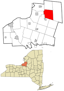
Richland is a town in the northeastern part of Oswego County, New York, United States. The population was 5,718 at the 2010 census.

<span class="mw-page-title-main">Schroeppel, New York</span> Town in New York, United States

Schroeppel is a town in Oswego County, New York, United States. The population was 8,501 at the 2010 census. The name derives from the Schroeppel family, early land owners of the area. Schroeppel is located in the southeast part of the county.

<span class="mw-page-title-main">Scriba, New York</span> Town in New York, United States

Scriba is a town in Oswego County, New York, United States. The population was 6,840 at the 2010 census. The town is named after landowner George Scriba.

<span class="mw-page-title-main">Volney, New York</span> Town in New York, United States

Volney is a town in Oswego County, New York, United States. The population was 5,926 at the 2010 census. The town was named after a French author, Constantin François de Chassebœuf, comte de Volney, who toured the area in 1808.

<span class="mw-page-title-main">Williamstown, New York</span> Town in New York, United States

Williamstown is a town in Oswego County, New York, United States. The population was 1,277 at the 2010 census.

<span class="mw-page-title-main">Seward, New York</span> Town in New York, United States

Seward is a town in Schoharie County, New York, United States. The population was 1,583 at the 2020 census. The town is named after senator, governor, and secretary of state William H. Seward.

<span class="mw-page-title-main">Burlington Township, Pennsylvania</span> Township in Pennsylvania, United States

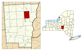
Burlington Township is a township in Bradford County, Pennsylvania, United States. It is part of Northeastern Pennsylvania. The population was 791 at the 2010 census. Children residing in the township are assigned to attend the Troy Area School District.

<span class="mw-page-title-main">Constantia, New York</span> Town in New York, United States

Constantia is a town in Oswego County, New York, United States. The population was 4,973 at the 2010 census. The town is located in the southeastern part of the county. Within the town is a hamlet and census-designated place of the same name.

<span class="mw-page-title-main">Minetto, New York</span> Town in New York, United States

Minetto is a town in Oswego County, New York, United States. The population was 1,659 at the 2010 census. It was formed in 1916 from the town of Oswego.

<span class="mw-page-title-main">Oswego (town), New York</span> Town in New York, United States

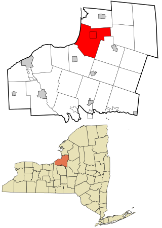
Oswego is a town in Oswego County, in the U.S. state of New York. The population was 7,984 at the 2010 census.

<span class="mw-page-title-main">Stillwater (village), New York</span> Village in New York, United States

Stillwater is a village in Saratoga County, New York, United States. The population was 1,754 at the 2020 census. There is a hamlet in Minerva, Essex County with the same name, which has nothing to do with this village. The Village of Stillwater is in the southeastern part of the Town of Stillwater, north of the City of Mechanicville.

<span class="mw-page-title-main">Stillwater, New York</span> Town in New York, United States

Stillwater is a town in Saratoga County, New York, United States, with a population of 8,287 at the 2010 census. The town contains a village called Stillwater. The town is at the eastern border of the county, southeast of Saratoga Springs and borders both Rensselaer and Washington counties. Saratoga National Historical Park is located within the town's limits. There is a hamlet in Minerva, Essex County, New York, with the same name which has nothing to do with this town.

References

  1. "2016 U.S. Gazetteer Files". United States Census Bureau. Retrieved July 5, 2017.
  2. 1 2 "Population and Housing Unit Estimates" . Retrieved June 9, 2017.
  3. "Oswego County Timeline". Archived from the original on February 6, 2012. Retrieved March 17, 2012.
  4. "Transportation | Oswego County Opportunities" . Retrieved October 20, 2018.
  5. "Census of Population and Housing". Census.gov. Retrieved June 4, 2015.
  6. "U.S. Census website". United States Census Bureau . Retrieved January 31, 2008.
  7. "National Register Information System". National Register of Historic Places . National Park Service. March 13, 2009.

43°34′29″N75°59′47″W / 43.57472°N 75.99639°W / 43.57472; -75.99639