Schroeppel, New York

Last updated

Schroeppel, New York
Oswego County New York incorporated and unincorporated areas Schroeppel highlighted.svg
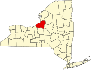
Location in Oswego County and the state of New York.
Coordinates: 43°15′27″N76°16′30″W / 43.25750°N 76.27500°W / 43.25750; -76.27500
Country United States
State New York
County Oswego
Area
[1]
  Total43.20 sq mi (111.88 km2)
  Land42.20 sq mi (109.30 km2)
  Water1.00 sq mi (2.58 km2)
Elevation
394 ft (120 m)
Population
 (2010)
  Total8,501
  Estimate 
(2016) [2]
8,208
  Density194.50/sq mi (75.10/km2)
Time zone UTC-5 (Eastern (EST))
  Summer (DST) UTC-4 (EDT)
ZIP code
13135
Area code 315
FIPS code 36-65618
GNIS feature ID0979471
Website Town Website

Schroeppel is a town in Oswego County, New York, United States. The population was 8,501 at the 2010 census. The name derives from the Schroeppel family, early land owners of the area. Schroeppel is located in the southeast part of the county.

Contents

History

The town of Schroeppel was formed in 1832 from the town of Volney.

The Schroeppel House was listed on the National Register of Historic Places in 1982. [3]

Geography

The southwestern town line, marked by the Oneida River, is the border of Onondaga County. The southwestern town boundary is partly formed by the Oswego River. The Erie Canal is on the southern border of the town.

According to the United States Census Bureau, the town has a total area of 43.2 square miles (112 km2), of which 42.3 square miles (110 km2) is land and 0.9 square miles (2.3 km2) (2.01%) is water.

Demographics

Historical population
CensusPop.Note
1840 2,098
1850 3,25855.3%
1860 4,01123.1%
1870 3,987−0.6%
1880 3,381−15.2%
1890 3,026−10.5%
1900 3,012−0.5%
1910 2,707−10.1%
1920 2,617−3.3%
1930 3,01015.0%
1940 3,2196.9%
1950 4,03725.4%
1960 5,55437.6%
1970 7,15328.8%
1980 8,01612.1%
1990 8,93111.4%
2000 8,566−4.1%
2010 8,501−0.8%
2016 (est.)8,208 [2] −3.4%
U.S. Decennial Census [4]

As of the census [5] of 2000, there were 8,566 people, 3,251 households, and 2,347 families residing in the town. The population density was 202.4 inhabitants per square mile (78.1/km2). There were 3,590 housing units at an average density of 84.8 per square mile (32.7/km2). The racial makeup of the town was 97.79% White, 0.39% African American, 0.68% Native American, 0.30% Asian, 0.09% from other races, and 0.75% from two or more races. Hispanic or Latino of any race were 0.84% of the population.

There were 3,251 households, out of which 36.9% had children under the age of 18 living with them, 55.6% were married couples living together, 12.0% had a female householder with no husband present, and 27.8% were non-families. 22.6% of all households were made up of individuals, and 9.4% had someone living alone who was 65 years of age or older. The average household size was 2.63 and the average family size was 3.06.

In the town, the population was spread out, with 28.1% under the age of 18, 7.2% from 18 to 24, 30.6% from 25 to 44, 23.9% from 45 to 64, and 10.1% who were 65 years of age or older. The median age was 36 years. For every 100 females, there were 99.0 males. For every 100 females age 18 and over, there were 94.1 males.

The median income for a household in the town was $39,662, and the median income for a family was $45,766. Males had a median income of $31,191 versus $27,864 for females. The per capita income for the town was $17,581. About 7.7% of families and 9.7% of the population were below the poverty line, including 12.4% of those under age 18 and 12.4% of those age 65 or over.

Communities and locations in Schroeppel

Related Research Articles

<span class="mw-page-title-main">Ira, New York</span> Town in New York, United States

Ira is a town in Cayuga County, New York, United States. The population was 2,145 at the 2020 census. The town is in the northern part of the county and is northwest of Syracuse.

<span class="mw-page-title-main">Black Brook, New York</span> Town in New York, United States

Black Brook is a town in Clinton County, New York, United States. The population was 1,497 at the 2010 census. It is named after a stream that flows through the town.

<span class="mw-page-title-main">Union Vale, New York</span> Town in New York, United States

Union Vale is a town in Dutchess County, New York, United States. The population was 4,558 at the 2020 census.
<span class="mw-page-title-main">Alexandria, New York</span> Town in New York, United States

Alexandria is a town in the Thousand Islands region of the U.S. state of New York, within Jefferson County. The town's population was 3,741 at the 2020 United States Census. The town is named after Alexander LeRay, the son of an early developer. The village of Alexandria Bay is within the town.

Lorraine is a town in Jefferson County, New York, United States. The population was 1,037 at the 2010 census, up from 930 in 2000. The town is named after Lorraine, a region in France.

Worth is a town in Jefferson County, New York, United States. The population was 231 at the 2010 census. The town is named after William Worth, a commander of troops during the Battle of Sackett's Harbor.

Montague is a town in Lewis County, New York, United States. The population was 78 at the 2010 census. The town is named after Mary Montague Pierpont, the daughter of the original owner.

<span class="mw-page-title-main">Florence, New York</span> Town in New York, United States

Florence is a town in Oneida County, New York, United States. The population was 1,025 at the 2010 census. The town is named after the city Florence in Italy.

<span class="mw-page-title-main">Sangerfield, New York</span> Town in New York, United States

Sangerfield is a town in Oneida County, New York, United States. The population was 2,561 at the 2010 census. The town is named after Jedediah Sanger, an early settler.

<span class="mw-page-title-main">Cicero, New York</span> Town in New York, United States

Cicero is a town in northern Onondaga County, New York, United States. As of the 2020 Census, the population was 31,435. The name of the town was assigned by a clerk interested in the classics, honoring Cicero, a Roman statesman.

<span class="mw-page-title-main">Lysander, New York</span> Town in New York, United States

Lysander is a town in Onondaga County, New York, United States. As of the 2020 Census, the population was 23,074. The town was named after Lysander, a Spartan military leader, by a clerk interested in the classics. Lying to the northwest of Syracuse, much of the town is suburban in character.

<span class="mw-page-title-main">Boylston, New York</span> Town in New York, United States

Boylston is a town in Oswego County, New York, United States. The population was 549 at the 2010 census. The name is that of the first landowner of the tract that became the town.

<span class="mw-page-title-main">Granby, New York</span> Town in New York, United States

Granby is a town in Oswego County, New York, United States. The population was 6,821 at the 2010 census.

<span class="mw-page-title-main">Hastings, New York</span> Town in New York, United States

Hastings is a town in Oswego County, New York, United States. Its population was 9,450 at the 2010 census. It is named after Hastings Curtiss, a prominent citizen and member of the State Assembly in 1824.

<span class="mw-page-title-main">New Haven, New York</span> Town in New York, United States

New Haven is a town in Oswego County, New York, United States. The population was 2,856 at the 2010 census.

<span class="mw-page-title-main">Orwell, New York</span> Town in New York, United States

Orwell is a town in Oswego County, New York, United States. The population was 1,167 at the 2010 census. The town was named after Orwell, Vermont.

<span class="mw-page-title-main">Palermo, New York</span> Town in New York, United States

Palermo is a town in Oswego County in the U.S. state of New York. The population was 3,664 at the 2010 census. The town is named after Palermo in Sicily.

<span class="mw-page-title-main">Volney, New York</span> Town in New York, United States

Volney is a town in Oswego County, New York, United States. The population was 5,926 at the 2010 census. The town was named after a French author, Constantin François de Chassebœuf, comte de Volney, who toured the area in 1808.

<span class="mw-page-title-main">Carlisle, New York</span> Town in New York, United States

Carlisle is a town in northern Schoharie County, New York, United States. The population was 1,768 at the 2020 census.

<span class="mw-page-title-main">Constantia, New York</span> Town in New York, United States

Constantia is a town in Oswego County, New York, United States. The population was 4,973 at the 2010 census. The town is located in the southeastern part of the county. Within the town is a hamlet and census-designated place of the same name.

References

  1. "2016 U.S. Gazetteer Files". United States Census Bureau. Retrieved July 5, 2017.
  2. 1 2 "Population and Housing Unit Estimates" . Retrieved June 9, 2017.
  3. "National Register Information System". National Register of Historic Places . National Park Service. March 13, 2009.
  4. U.S. Decennial Census; census.gov
  5. "U.S. Census website". United States Census Bureau . Retrieved January 31, 2008.