Williamstown, New York

Last updated

Williamstown, New York
Williamstown war memorial.jpg
Town war memorial, July 2022
Nickname(s): 
The Cranberry Capital of New York, Billytown
Oswego County New York incorporated and unincorporated areas Williamstown highlighted.svg
Location in Oswego County and the state of New York.
Coordinates: 43°27′11″N75°53′59″W / 43.45306°N 75.89972°W / 43.45306; -75.89972
Country United States
State New York
County Oswego
EstablishedMarch 24, 1804
Area
[1]
  Total39.16 sq mi (101.43 km2)
  Land38.67 sq mi (100.16 km2)
  Water0.49 sq mi (1.27 km2)
Elevation
633 ft (193 m)
Population
 (2010)
  Total1,277
  Estimate 
(2016) [2]
1,265
  Density32.71/sq mi (12.63/km2)
Time zone UTC-5 (Eastern (EST))
  Summer (DST) UTC-4 (EDT)
ZIP code
13493
Area code 315
FIPS code 36-82073 [3]
GNIS feature ID0979641 [4]

Williamstown is a town in Oswego County, New York, United States. The population was 1,277 at the 2010 census.

Contents

The Town of Williamstown is on the county's eastern boundary.

History

After the Revolutionary War, Williamstown did not exist until plans were made to settle west of the Hudson River. In 1791 Nicholas and John Roosevelt purchased 525,000 that covered most of Oswego, Oneida, and a small chunk of Herkimer counties known as the Roosevelt purchase. In 1794 it was then purchased by George Scriba, which then became the Scriba Patent. Scriba then broke up most of the land that he purchased into townships and given what is now Williamstown the name Franklin, Township No.5. Ichabod Comstock was the first to settle in Franklin in 1801. Judge Henry Williams relocated to Franklin from Camden, New York in 1802 and shortly after Williams came to Franklin the people renamed the town Williamstown in Williams’s honor. Williamstown became an official town after separating from Mexico, part of Oneida County at the time on March 24, 1804. Oswego County wasn’t formed until 1816. [5]

Geography

Williamstown is bordered to the northeast by Redfield, to the northwest by Orwell, to the west by Albion, to the south by Amboy, and to the east by the Oneida County town of Florence.

According to the United States Census Bureau, the town has a total area of 39.2 square miles (102 km2), of which 38.7 square miles (100 km2) is land and 0.5 square miles (1.3 km2) (1.20%) is water.

Demographics

Historical population
CensusPop.Note
1820 652
1830 606−7.1%
1840 84238.9%
1850 1,12133.1%
1860 1,1442.1%
1870 1,83360.2%
1880 1,820−0.7%
1890 1,215−33.2%
1900 1,023−15.8%
1910 896−12.4%
1920 767−14.4%
1930 706−8.0%
1940 7100.6%
1950 707−0.4%
1960 7394.5%
1970 88319.5%
1980 1,00814.2%
1990 1,27926.9%
2000 1,3505.6%
2010 1,277−5.4%
2016 (est.)1,265 [2] −0.9%
U.S. Decennial Census [6]

As of the census [3] of 2000, there were 1,350 people, 449 households, and 338 families residing in the town. The population density was 34.9 inhabitants per square mile (13.5/km2). There were 634 housing units at an average density of 16.4 per square mile (6.3/km2). The racial makeup of the town was 98.07% White, 0.37% African American, 0.15% Native American, 0.37% Asian, 0.30% from other races, and 0.74% from two or more races. Hispanic or Latino of any race were 1.19% of the population.

There were 449 households, out of which 43.0% had children under the age of 18 living with them, 55.9% were married couples living together, 11.8% had a female householder with no husband present, and 24.5% were non-families. 19.8% of all households were made up of individuals, and 7.3% had someone living alone who was 65 years of age or older. The average household size was 3.01 and the average family size was 3.41.

In the town, the population was spread out, with 34.6% under the age of 18, 9.2% from 18 to 24, 28.8% from 25 to 44, 20.0% from 45 to 64, and 7.4% who were 65 years of age or older. The median age was 31 years. For every 100 females, there were 95.1 males. For every 100 females age 18 and over, there were 97.5 males.

The median income for a household in the town was $31,509, and the median income for a family was $34,688. Males had a median income of $32,566 versus $21,375 for females. The per capita income for the town was $12,599. About 13.5% of families and 14.2% of the population were below the poverty line, including 13.8% of those under age 18 and 13.9% of those age 65 or over.

Communities and locations in Williamstown

NY 183 at the Williamstown town line.jpg

Notable people

Related Research Articles

<span class="mw-page-title-main">Oswego County, New York</span> County in New York, United States

Oswego County is a county in the U.S. state of New York. As of the 2020 census, the population was 117,525. The county seat is Oswego. The county name is from a Mohawk-language word meaning "the pouring out place", referring to the point at which the Oswego River feeds into Lake Ontario at the northern edge of the county in the city of Oswego. The county is part of the Central New York region of the state.

<span class="mw-page-title-main">Annsville, New York</span> Town in New York, United States

Annsville is a town in Oneida County, New York, United States. At the 2010 census the town population was 3,012. The town is named after Ann Bloomfield, wife of a founder.

<span class="mw-page-title-main">Ava, New York</span> Town in New York, United States

Ava is a town in Oneida County, New York, United States. The population was 678 at the 2010 census..

<span class="mw-page-title-main">Florence, New York</span> Town in New York, United States

Florence is a town in Oneida County, New York, United States. The population was 1,025 at the 2010 census. The town is named after the city Florence in Italy.

<span class="mw-page-title-main">Sangerfield, New York</span> Town in New York, United States

Sangerfield is a town in Oneida County, New York, United States. The population was 2,561 at the 2010 census. The town is named after Jedediah Sanger, an early settler.

<span class="mw-page-title-main">Verona, New York</span> Town in New York, United States

Verona is a town in southwestern Oneida County, New York, United States. The population was 6,293 at the 2010 census. The town was named after Verona, Italy.

<span class="mw-page-title-main">Vienna, New York</span> Town in New York, United States

Vienna is a town in Oneida County, New York, United States. The population was 5,440 at the 2010 census. The town is named after the capital of Austria.

<span class="mw-page-title-main">Cicero, New York</span> Town in New York, United States

Cicero is a town in northern Onondaga County, New York, United States. As of the 2020 Census, the population was 31,435. The name of the town was assigned by a clerk interested in the classics, honoring Cicero, a Roman statesman.

<span class="mw-page-title-main">Clay, New York</span> Town in New York, United States

Clay is a town in Onondaga County, New York, United States. As of the 2020 Census, the population was 60,527, making it Syracuse's most populous suburb. The town was named after American attorney and statesman Henry Clay.

<span class="mw-page-title-main">Lysander, New York</span> Town in New York, United States

Lysander is a town in Onondaga County, New York, United States. As of the 2020 Census, the population was 23,074. The town was named after Lysander, a Spartan military leader, by a clerk interested in the classics. Lying to the northwest of Syracuse, much of the town is suburban in character.

<span class="mw-page-title-main">Albion, Oswego County, New York</span> Town in New York, United States

Albion is a town in the northeastern part of Oswego County, New York, United States. The population was 2,009 at the 2020 census.

<span class="mw-page-title-main">Hastings, New York</span> Town in New York, United States

Hastings is a town in Oswego County, New York, United States. Its population was 9,450 at the 2010 census. It is named after Hastings Curtiss, a prominent citizen and member of the State Assembly in 1824.

<span class="mw-page-title-main">Orwell, New York</span> Town in New York, United States

Orwell is a town in Oswego County, New York, United States. The population was 1,167 at the 2010 census. The town was named after Orwell, Vermont.

<span class="mw-page-title-main">Redfield, New York</span> Town in New York, United States

Redfield is a town in Oswego County, New York, United States. The population was 550 at the 2010 census.

<span class="mw-page-title-main">Schroeppel, New York</span> Town in New York, United States

Schroeppel is a town in Oswego County, New York, United States. The population was 8,501 at the 2010 census. The name derives from the Schroeppel family, early land owners of the area. Schroeppel is located in the southeast part of the county.

<span class="mw-page-title-main">Scriba, New York</span> Town in New York, United States

Scriba is a town in Oswego County, New York, United States. The population was 6,840 at the 2010 census. The town is named after landowner George Scriba.

<span class="mw-page-title-main">West Monroe, New York</span> Town in New York, United States

West Monroe is a town in Oswego County, New York, United States. The population was 4,252 at the 2010 census.

<span class="mw-page-title-main">Constantia, New York</span> Town in New York, United States

Constantia is a town in Oswego County, New York, United States. The population was 4,973 at the 2010 census. The town is located in the southeastern part of the county. Within the town is a hamlet and census-designated place of the same name.

<span class="mw-page-title-main">Mexico, New York</span> Town in New York, United States

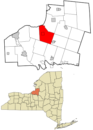
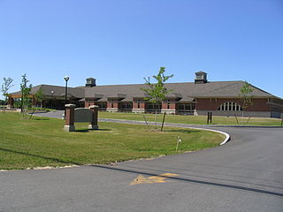
Mexico is a town in the northeastern section of Oswego County, New York, United States. The population was 5,197 at the 2010 census. The town contains a village also named Mexico.

Texas is a hamlet in Oswego County, New York, United States, near the southeastern corner of Lake Ontario. It is officially part of the town of Mexico.

References

  1. "2016 U.S. Gazetteer Files". United States Census Bureau. Retrieved July 5, 2017.
  2. 1 2 "Population and Housing Unit Estimates" . Retrieved June 9, 2017.
  3. 1 2 "U.S. Census website". United States Census Bureau . Retrieved January 31, 2008.
  4. "US Board on Geographic Names". United States Geological Survey. October 25, 2007. Retrieved January 31, 2008.
  5. Gorski, Glenna, Clevland, Roberta, Loomis, Willard, Gardner, Florance, La Duke, Anne."A Look at the Past: Williamstown, NY. "Compco, Inc., 1991. Print.
  6. "Census of Population and Housing". Census.gov. Retrieved June 4, 2015.
  7. "Looking back at Happy Valley, a farm town uprooted in the 1930s to make way for wildlife". newyorkupstate. April 27, 2016. Retrieved March 1, 2020.
  8. 1 2 3 Gorski, Glenna, Cleveland, Roberta, Loomis, Willard, Gardner, Florence, La Duke, Anne. “A Look at the Past: Williamstown, NY.” Compco, Inc., 1991.Print.
  9. Palmer, Richard. “Maple Hill and the Williamstown & Redfield Railroad.” Rome Sentinel.
  10. Gorski, Glenna, Cleveland, Roberta, Loomis, Willard, Gardner, Florence, La Duke, Anne. “The Magnificent Jonathan Case Wall.” Williamstown Historical Society,2012.Print.

43°25′26″N75°53′24″W / 43.42389°N 75.89000°W / 43.42389; -75.89000