
The River Ancholme is a river in Lincolnshire, England, and a tributary of the Humber. It rises at Ancholme Head, a spring just north of the village of Ingham and immediately west of the Roman Road, Ermine Street. It flows east and then north to Bishopbridge, where it is joined by the Rase. North of Bishopbridge it flows through the market town of Brigg before draining into the Humber at South Ferriby. It drains a significant part of northern Lincolnshire between the Trent and the North Sea.

Bolingbroke, now called Old Bolingbroke, is a village and civil parish in the East Lindsey district of Lincolnshire, England. Its present boundaries were formed by the amalgamation of the Parishes of Bolingbroke and Hareby in 1739. The population at the 2011 census was 325.

West Lindsey is a local government district in Lincolnshire, England. Its council is based in Gainsborough.
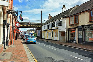
Market Rasen is a town and civil parish within the West Lindsey district of Lincolnshire, England. The River Rase runs through it east to west, approximately 13 miles (21 km) north-east from Lincoln, 18 miles (29 km) east from Gainsborough, 14 miles west of Louth and 16 miles (26 km) south-west from Grimsby. It lies on the main road between Lincoln and Grimsby, the A46 and is on National Cycle Route 1 of the National Cycle Network.

Amcotts is a village and civil parish in the North Lincolnshire district of Lincolnshire, England, and on the Isle of Axholme. The village is situated north-west from Scunthorpe, and on the west bank of the River Trent facing Flixborough on the east bank. The 2001 Census recorded a population of 219 for the parish, increasing to 262 at the 2011 census.
Bishop Norton is a village and the main settlement of the civil parish of the same name in the West Lindsey district of Lincolnshire, England. The village is approximately 8 miles (13 km) north-west from the market town of Market Rasen, and is close to the A15 road. According to the 2001 Census it had a population of 233, including Atterby and increasing to 308 at the 2011 census.

Roughton is a village and civil parish in the East Lindsey district of Lincolnshire, England. Roughton population in 2011 was 644.

Kirkby la Thorpe is a village and civil parish in North Kesteven district of Lincolnshire, England.The population at the 2011 census was 1,120. It lies 1.5 miles (2.4 km) east from Sleaford. The village is near the start of the A17 Sleaford bypass.

Toft Newton is a civil parish in the West Lindsey district of Lincolnshire, England. It consists of the small villages of Toft next Newton and Newton by Toft, and the hamlet of Newtoft. It is 4 miles (6 km) west from Market Rasen. According to the 2001 Census it had a population of 522, decreasing to 457 at the 2011 census.

Wyville is a village in the civil parish of Wyville cum Hungerton, in the South Kesteven district of Lincolnshire, England, and situated approximately 5 miles (8 km) south-west from Grantham The whole parish covers about 1,670 acres (6.8 km2). The population is included in the civil parish of Little Ponton and Stroxton.

Lenton is a hamlet in the district of South Kesteven, Lincolnshire, England. It is situated approximately 7 miles (11 km) south-east from Grantham, and is part of the Lenton, Keisby and Osgodby civil parish.
Kingerby is a village and former civil parish in the West Lindsey district of Lincolnshire, England. It is situated 5 miles (8.0 km) north west from the town of Market Rasen. The hamlet of Bishop Bridge lies about 1.5 miles (2.4 km) to the south-west.

Usselby is a hamlet in the West Lindsey district of Lincolnshire, England, United Kingdom. It is approximately 3 miles (5 km) north-west from the town of Market Rasen. Usselby, a former civil parish, is part of Osgodby civil parish.

Kirkby cum Osgodby, sometimes called Kirkby, is hamlet and former civil parish in the West Lindsey district of Lincolnshire, England. It lies 3.5 miles (5.6 km) north-west from Market Rasen and less than 1 mile (1.6 km) west from the village and civil parish of Osgodby.

Middle Rasen is a village and civil parish in the West Lindsey district of Lincolnshire, England, located about 1.5 miles (2.4 km) west from the town of Market Rasen. The population of the civil parish at the 2011 census was 2,043.
Snelland is a village and civil parish in the West Lindsey district of Lincolnshire, England. It is situated approximately 9 miles (14 km) north-east from the city and county town of Lincoln and about 5 miles (8.0 km) from the town of Market Rasen. The civil parish includes the hamlet of Swinthorpe. The population at the 2011 census was included in the civil parish of Friesthorpe.

West Rasen is a village and civil parish in the West Lindsey district of Lincolnshire, England. It is situated on the A631 road, and approximately 3 miles (5 km) west from Market Rasen.
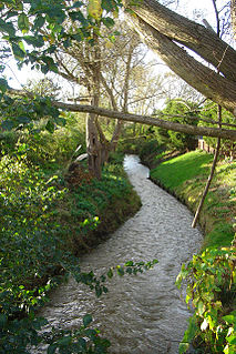
The River Rase is 16 mile (25 km) long tributary of the River Ancholme that flows through Lincolnshire, in the east of England.
Lenton, Keisby and Osgodby is a civil parish in South Kesteven, Lincolnshire, England. The population of the civil parish at the 2011 census was 187. It is located along the river and in the valleys of the East Glen at its headwaters near Ingoldsby, where several minor streams join together.
Kingthorpe is a hamlet in the West Lindsey district of Lincolnshire, England. The hamlet is in the civil parish of Apley, and is 10 miles (16 km) east from the city and county town of Lincoln and 9 miles (14 km) south from the market town of Market Rasen. It sits on the B1202 road from Wragby to Bardney, and 1 mile (1.6 km) to the east from the parish village of Apley.

