Parvathipuram, Andhra Pradesh

Last updated

Parvathipuram
Chanduphotography.jpg
Main road in Parvathipuram
India Andhra Pradesh location map (current).svg
Red pog.svg
Parvathipuram
Location in Andhra Pradesh, India
India location map.svg
Red pog.svg
Parvathipuram
Parvathipuram (India)
Coordinates: 18°46′48″N83°25′30″E / 18.78°N 83.425°E / 18.78; 83.425
CountryFlag of India.svg  India
State Andhra Pradesh
District Parvathpuram Manyam
Government
  Type Municipality
  BodyParvathipuram Municipality, BUDA
  MLAAlajangi Jogarao
Area
[1]
  Total11.24 km2 (4.34 sq mi)
Population
 (2011) [2]
  Total53,844
  Density4,800/km2 (12,000/sq mi)
Language
  Official Telugu
Time zone UTC+5:30 (IST)
PIN
535 501
Telephone code91–8963
Vehicle Registration AP35 (Former)
AP39 (from 30 January 2019) [3]
Website Parvathipuram Municipality
Parvathipuram Town railway station Parvathipuram town railway station.jpg
Parvathipuram Town railway station
A view of Eastern Ghats near Parvathipuram A view of Eastern Ghats from outskirts of Parvathipuram.jpg
A view of Eastern Ghats near Parvathipuram

Parvathipuram is a municipality located at Parvathipuram Manyam district of Indian state of Andhra Pradesh. It is the administrative headquarters of Parvathipuram Manyam district and headquarters of Parvathipuram revenue division and Parvathipuram mandal. This revenue division shares a border with various districts in Odisha. [4]

Contents

Geography

Parvathipuram is located at 18°46'N 83°25'E. It has an average elevation of 120 meters (393.7 feet).

Demographics

As of 2011 census, Parvathipuram had a population of 53,844. The total population constitute, 26,811 males and 27,033 females a sex ratio of 1008 females per 1000 males. 5,048 children are in the age group of 0–6 years, of which 2,607 are boys and 2,441 are girls a ratio of 936 per 1000. The average literacy rate stands at 79.14% with 38,618 literates, significantly higher than the state average of 67.41%. [2] [5]

Government and politics

Parvathipuram is represented by Parvathipuram (SC) (Assembly constituency) for Andhra Pradesh Legislative Assembly and Araku (Lok Sabha constituency). Alajangi Jogarao is the present MLA of the constituency representing YSR Congress Party. [6] [7] [8]

Transport

Train Transport

Parvathipuram is on the Jharsuguda–Vizianagaram line. There are two railway stations Parvathipuram and Parvathipuram Town within 1 kilometre (0.62 mi).

Parvathipuram railway station Parvathipuram railway station.jpg
Parvathipuram railway station

Road Transport

There is Road connectivity between Major towns of Andhra pradesh and Odisha to Parvathipuram. APSRTC is Providing Daily Bus facility to Vijayawada and other major cities Visakhapatnam, Vizianagaram, Rajahmundry, Srikakulam, Kakinada of Andhrapradesh and Various Places of Odisha.

Air Transport

The Nearest Airport is located in Visakhapatnam which is 150 km away from Parvathipuram.

Tourism Attractions

Parvathipuram has many tourist attractions are around and inside the town.

Devotional

Many Temples are Located around Parvathipuram area Kasi Viswanath temple Addapusila is the oldest historic temple which is located 5 km away from Parvathipuram town.

Sri Venkateswara Swamy Temple, Thotapalli is most popularly known as Chinna Tirupathi is famous for Lord Balaji; many pilgrims visit this temple from various states.

St. Paul's Lutheran Church is one of the oldest church in Parvathipuram area which was built in 1888. It is located at Main road Belagam and also a Roman Catholic church is also another attraction in this area.

Catholic church Parvathipuram Catholic church parvathipuram.jpg
Catholic church Parvathipuram

Dams and Reservoirs

Thotapalli old Bridge Thotapalli old Bridge.jpg
Thotapalli old Bridge

Entertainment

Cinemas

Parks

Janjavathi Rubber Dam Janjavathi Rubber Dam.jpg
Janjavathi Rubber Dam

Agriculture

Parvathipuram is agriculture based area here mainly cultivating paddy, cashew nuts, mangoes, mahua and other minor crops. Farmers in this area are mainly depending on Janjavathi Rubber Dam and Thotapalli Reservoir for agriculture. Thotapalli Reservoir is also supplying drinking water to Parvathipuram town.

Paddy fields near parvathipuram Crops near parvathipuram.jpg
Paddy fields near parvathipuram

Climate

Climate data for Parvathipuram, Andhra Pradesh
MonthJanFebMarAprMayJunJulAugSepOctNovDecYear
Mean daily maximum °C (°F)26
(79)
28.3
(82.9)
33.2
(91.8)
35.1
(95.2)
36.1
(97.0)
34.2
(93.6)
30.9
(87.6)
30.8
(87.4)
31.2
(88.2)
30.9
(87.6)
27
(81)
25.5
(77.9)
30.8
(87.4)
Mean daily minimum °C (°F)14.3
(57.7)
16.8
(62.2)
20.1
(68.2)
25.2
(77.4)
27.2
(81.0)
26.8
(80.2)
25.3
(77.5)
25.1
(77.2)
25
(77)
21.5
(70.7)
17
(63)
14.3
(57.7)
21.6
(70.8)
Average rainfall mm (inches)18
(0.7)
15
(0.6)
21
(0.8)
31
(1.2)
90
(3.5)
192
(7.6)
289
(11.4)
312
(12.3)
264
(10.4)
238
(9.4)
38
(1.5)
21
(0.8)
1,529
(60.2)
Source: en.climate-data.org

Education

Parvathipuram is a Major Educational Hub for Surrounding Mandals and villages. Here are Many Private, public schools and Junior&Degree colleges are Located.

  1. DR. YSR Horticultural University, College of Horticulture]], Parvathipuram
  2. Sri Venkateswara Degree college, Parvathipuram
  3. Gayatri Degree college
    Sri Venkateswara Degree College Sri Venkateswara Degree college.jpg
    Sri Venkateswara Degree College
  4. Janahita Degree College
  5. Government Polytechnic College, Mr nagaram
  6. Shirdhi Sai Polytechnic College
  7. APTWR Jr College of Excellence, Parvathipuram
  8. Bhaskar Junior College
  9. DBK Arts & Sci Jr College, Sunki
  10. Government junior college, Parvathipuram
  11. Sri Sa Iram Jr College
  12. Vasavi junior College
  1. Pratibha Excellence school, Parvathipuram
  2. DVMM School, Parvathipuram
  3. Lions Eng. Medium school, Parvathipuram
  4. Kavirayani Public School, Parvathipuram
  5. St. Peters English Medium School, Parvathipuram
  6. R.C.M. St Johns boys high school, Parvathipuram
  7. R.C.M St Josephs Girls High School, Parvatipuram
  8. Surya teja public school, Parvathipuram
  9. Suresh Public school, Parvathipuram
  10. Noble Public school, Parvathipuram
  11. Bhaskar high School, Parvathipuram
  12. Janahita Public school, Parvathipuram
  13. sridhar public school, Parvathipuram
  14. Viswa Vignana Vidyalayam, Parvathipuram
  15. Ravindra Bharathi School, Parvathipuram
  16. Narayana E Techno School, Parvathipuram
  17. Bharatha Maata High School, Parvathipuram
  18. Aditya Public School, Parvathipuram
  19. Sri Krishna Public School, Parvathipuram
  20. K.P.M High school Kothavalasa parvathipuram

Notable people

Cityscape

See also

Related Research Articles

<span class="mw-page-title-main">Vizianagaram district</span> District of Andhra Pradesh in India

Vizianagaram district is one of the six districts in the Uttarandhra region of the Indian state of Andhra Pradesh with its headquarters located at Vizianagaram. The district was once the part of ancient Kalinga.Saripilli Dibbilingeswara temple, Jayathi Mallikarjuna Temple are the finest examples of ancient Eastern Ganga Dynasty built monuments in the district. The district is bounded on the east by the district of Srikakulam, north by Parvathipuram Manyam south by Visakhapatnam, Anakapalli, southeast by the Bay of Bengal, and west by Alluri Sitharama Raju district. It was formed on 1 June 1979, with some parts carved from the neighbouring districts of Srikakulam and Visakhapatnam. The district is named after the princely state of Vizianagaram. In 2011, it was the least populous district in Andhra Pradesh.

<span class="mw-page-title-main">Kadapa district</span> District of Andhra Pradesh in India

Kadapa district is one of the twenty six districts in the Indian state of Andhra Pradesh. In 2022 reorganisation of Andhra Pradesh districts, the district boundary is largely restricted to Kadapa parliamentary constituency area. It is also one of the eight districts in the Rayalaseema region. Kadapa is the administrative headquarters for this district.

<span class="mw-page-title-main">Srikakulam district</span> District of Andhra Pradesh in India

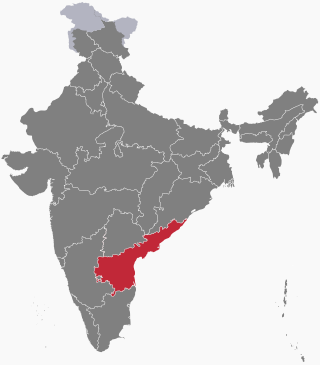
Srikakulam district is one of the twenty-six districts of the Indian state of Andhra Pradesh, located in the Uttarandhra region of the state, with its headquarters located at Srikakulam. It is one of the six districts, located in the extreme northeastern direction of the state. It was formerly known as Chicacole, and was under Ganjam district till 1936 April 1, then merged under Vizagapatam district. Srikakulam district forms the core area of Kalinga where most of its historical capitals like Kalinganagari, pithunda, Dantapuram are located.

<span class="mw-page-title-main">Proddatur</span> City in Andhra Pradesh, India

Proddatur (1915) is a city in the YSR Kadapa District of Andhra Pradesh, located on the banks of the Penna River. The city is a municipality, and also the mandal headquarters of Proddatur mandal. It is the second-largest town in former Kadapa District. It is the oldest municipality which formed before Independence.

Vuyyuru is a town in Krishna district of the Indian state of Andhra Pradesh. It is a Nagar panchayat and the headquarters of Vuyyuru Mandal. It is emerging as neighbourhood of Vijayawada, India situated 30 km away.

<span class="mw-page-title-main">Nagavali River</span> River in India

The River Nagavali also known as Langulya is one of the main rivers of Southern Odisha and Andhra States in India, between Rushikulya and Godavari basins.

<span class="mw-page-title-main">Balijipeta</span> Village in Andhra Pradesh, India

Baliji-peta or Baligi-peta is a village in Parvathipuram Manyam district of the Indian state of Andhra Pradesh.

Makkuva is a village in Parvathipuram Manyam district of the Indian state of Andhra Pradesh.

Naguru is a village and panchayat in Garugubilli mandal in Parvathipuram Manyam district of Andhra Pradesh, India. Naguru is a small village with a population of around 5000. Most of the people are employed in cultivation and cattle. Naguru was an assembly constituency in Andhra Pradesh till restructuring in 2009. It is located on the highway connecting Parvathipuram - Srikakulam, just 17 km from Parvathipuram. One who wants to visit Naguru, has to reach Parvathipuram first via train and from there can get a bus to Naguru easily.

Battili is a town in Bhamini Mandal of Parvathipuram Manyam district in Andhra Pradesh, India.

Dr. YSR University of Health Sciences, formerly known as Dr. NTR University of Health Sciences, is a public university in the city of Vijayawada, Andhra Pradesh.

<span class="mw-page-title-main">Geography of Andhra Pradesh</span>

Andhra Pradesh lies between 12°41' and 19.07°N latitude and 77° and 84°40'E longitude, and is bordered by Telangana to the north and west, Chhattisgarh to the north-west, Orissa to the north, the Bay of Bengal to the east, Tamil Nadu to the south and Karnataka to the southwest and west. Andhra Pradesh has a coastline of around 974 km, which gives it the second longest coastline in the nation. Two major rivers, the Godavari and the Krishna run across the state. A small enclave 12 sq mi (30 km²), the Yanam district of Puducherry, lies in the Godavari Delta in the north east of the state. The state includes the eastern part of Deccan plateau as well as a considerable part of the Eastern Ghats.

<span class="mw-page-title-main">Outline of Andhra Pradesh</span> State of India, located on its SE coast

The following outline is provided as an overview of and topical guide to Andhra Pradesh:

Thotapalli Barrage is located in Garugubilli Mandal, Parvathipuram Manyam district of Andhra Pradesh State. It was named after the freedom fighter and Political leader Sardar Gouthu Latchanna. The project construction was in between 2003 and 2015. This Project was inaugurated by Andhra Pradesh Chief Minister Nara Chandra babu Naidu on 10 September 2015. The Project provides irrigation to 1,20,000 acres in Srikakulam and Parvathipuram Manyam districts.

Salur mandal is one of the 34 mandals in Parvathipuram Manyam district of the Indian state of Andhra Pradesh. It is administration under Parvathipuram revenue division and headquartered at Salur. The mandal is bounded by Makkuva, Ramabhadrapuram, Pachipenta and Bobbili mandals. A portion of it also borders the state of Odisha.


Makkuva mandal is one of the 34 mandals in Parvathipuram Manyam district of the Indian state of Andhra Pradesh. It is administration under Parvathipuram revenue division and headquartered at Makkuva. The mandal is bounded by Salur mandal on South & West, Parvathipuram mandal on North, Seethanagaram mandal on east and Bobbili mandal on south east. A portion of it also borders the Narayanapatna block of the Koraput district of Odisha on north west.


Pachipenta mandal is one of the 34 mandals in Parvathipuram Manyam district of the Indian state of Andhra Pradesh. It is administration under Parvathipuram revenue division and headquartered at Pachipenta. The mandal is bounded by Salur, Ramabhadrapuram and Mentada mandals. A portion of it also borders the state of Odisha.

<span class="mw-page-title-main">Parvathipuram Manyam district</span> District in Andhra Pradesh, India

Parvathipuram Manyam district is a district in the Indian state of Andhra Pradesh. With Parvathipuram as its administrative headquarters, it became functional from 4th April 2022. The district was formed from Parvathipuram revenue division from Vizianagaram district and part of Palakonda revenue division of Srikakulam district. The district was once part of ancient Kalinga. The famous Kamalingeswara swamy temple was built in the regin of King Rajaraja Deva of Eastern Ganga Dynasty of Odisha in 11th century CE.

References

  1. "Municipalities, Municipal Corporations & UDAs" (PDF). Directorate of Town and Country Planning. Government of Andhra Pradesh. Archived from the original (PDF) on 28 January 2016. Retrieved 29 January 2016.
  2. 1 2 "Census 2011". The Registrar General & Census Commissioner, India. Retrieved 19 August 2014.
  3. "New 'AP 39' code to register vehicles in Andhra Pradesh launched". The New Indian Express. Vijayawada. 31 January 2019. Archived from the original on 3 February 2019. Retrieved 9 June 2019.
  4. "District Profile". Vizianagaram District Official website. National Informatics Centre. Archived from the original on 12 August 2014. Retrieved 3 November 2014.
  5. "Literacy of AP (Census 2011)" (PDF). Official Portal of Andhra Pradesh Government. p. 43. Archived from the original (PDF) on 14 July 2014. Retrieved 5 September 2014.
  6. "Delimitation of Parliamentary and Assembly Constituencies Order, 2008" (pdf). Election Commission of India. p. 22. Retrieved 11 October 2014.
  7. "MLA". AP State Portal. Archived from the original on 8 October 2014. Retrieved 12 October 2014.
  8. "Tenali Assembly 2014 Election Results". Elections.in. Retrieved 13 October 2014.