
Newberry National Volcanic Monument was designated on November 5, 1990, to protect the area around the Newberry Volcano in the U.S. state of Oregon. The monument was created within the boundaries of the Deschutes National Forest, which is managed by the U.S. Forest Service, and includes 54,822 acres of lakes, lava flows, and geologic features in central Oregon.

Newberry Volcano is a large active shield-shaped stratovolcano located about 20 miles (32 km) south of Bend, Oregon, United States, 35 miles (56 km) east of the major crest of the Cascade Range, within the Newberry National Volcanic Monument. Its highest point is Paulina Peak. The largest volcano in the Cascade Volcanic Arc, Newberry has an area of 1,200 square miles (3,100 km2) when its lava flows are taken into account. From north to south, the volcano has a length of 75 miles (121 km), with a width of 27 miles (43 km) and a total volume of approximately 120 cubic miles (500 km3). It was named for the geologist and surgeon John Strong Newberry, who explored central Oregon for the Pacific Railroad Surveys in 1855. The surrounding area has been inhabited by Native American populations for more than 10,000 years.

Central Oregon is a geographic region in the U.S. state of Oregon and is traditionally considered to be made up of Deschutes, Jefferson, and Crook counties. Other definitions include larger areas, often encompassing areas to the north towards the Columbia River, eastward towards Burns, or south towards Klamath Falls. These three counties have a combined population of 200,431 as of the 2010 census, with Deschutes the largest of the three counties, having approximately four times the population of the other two counties combined. As of 2015, the most populous city in the region is Bend, with an estimated 87,014 residents. As defined by the three county definition, Central Oregon covers 7,833 square miles (20,290 km2) of land. Central Oregon has had 3 record tourism years beginning in 2012. Over 2.2 million people visited Central Oregon in 2012 and again in 2013.
Lava Butte is a cinder cone in central Oregon, United States, just west of U.S. Route 97 between the towns of Bend, and Sunriver in Deschutes County. It is part of a system of small cinder cones on the northwest flank of Newberry Volcano, a massive shield volcano which rises to the southeast. The cinder cone is capped by a crater which extends about 60 feet (20 m) deep beneath its south rim, and 160 feet (50 m) deep from the 5,020-foot (1,530 m) summit on its north side. Lava Butte is part of the Newberry National Volcanic Monument.

The Deschutes National Forest is a United States National Forest located in parts of Deschutes, Klamath, Lake, and Jefferson counties in central Oregon. It comprises 1.8 million acres (7,300 km2) along the east side of the Cascade Range. In 1908, the Deschutes National Forest was established from parts of the Blue Mountains, Cascade, and Fremont National Forests. In 1911, parts of the Deschutes National Forest were split off to form the Ochoco and Paulina National Forests, and parts of the Cascade and Oregon National Forests were added to the Deschutes. In 1915, the lands of the Paulina National Forest were rejoined to the Deschutes National Forest. A 1993 Forest Service study estimated that the extent of old growth in the forest was 348,100 acres (140,900 ha). Within the boundaries of the Deschutes National Forest is the Newberry National Volcanic Monument, containing cinder cones, lava flows, and lava tubes. The Deschutes National Forest as a whole contains in excess of 250 known caves. The forest also contains five wilderness areas, six National Wild and Scenic Rivers, the Oregon Cascade Recreation Area, and the Metolius Conservation Area. Forest headquarters are located in Bend, Oregon. There are local ranger district offices in Bend, Crescent, and Sisters.

The Crooked River is a tributary, 125 miles (201 km) long, of the Deschutes River in the U.S. state of Oregon. The river begins at the confluence of the South Fork Crooked River and Beaver Creek. Of the two tributaries, the South Fork Crooked River is the larger and is sometimes considered part of the Crooked River proper. A variant name of the South Fork Crooked River is simply "Crooked River". The Deschutes River flows north into the Columbia River.

Four Craters Lava Field is a basaltic volcanic field located south east of Newberry Caldera in the U.S. state of Oregon. The volcanic field covers about 30 square kilometers. Four Pleistocene cinder cones are the source of the flows in the field and are aligned along a fissure trending N 30° W. The cones rise 75 to 120 meters above the flows and the distance between the northernmost and southernmost cones is about 3.5 kilometers.

The Imnaha Guard Station is a rustic cabin located in the Rogue River-Siskiyou National Forest in western Oregon, United States. It was originally built to house fire crews assigned to patrol the surrounding National Forest. In the 1990s, the United States Forest Service began renting the Imnaha Guard Station to recreational visitors. The Imnaha Guard Station is listed on the National Register of Historic Places.

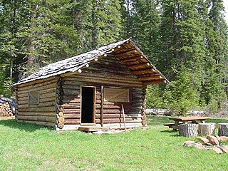
The Cabin Lake Guard Station is a Forest Service compound consisting of six simple rustic buildings located in the Deschutes National Forest in central Oregon. It was originally built as a district ranger station for the Fort Rock Ranger District. It was later converted to a summer guard station. The guard station is now closed, but the adjacent campground is open. While still very remote, it is a popular location for bird watching and nature photography. The Cabin Lake Guard Station is listed on the National Register of Historic Places.

The Clackamas Lake Ranger Station Historic District is a Forest Service compound consisting of eleven historic buildings located in the Mount Hood National Forest in the Cascade Mountains of northern Oregon. It was originally built as a district ranger station for the Clackamas Lake Ranger District. It was later converted to a summer guard station. Today, the Forest Service rents the historic ranger's residence to recreational visitors. The Clackamas Lake Ranger Station is listed as a historic district on the National Register of Historic Places.
The Willow Prairie Cabin is a rustic one-room cabin located in the Rogue River-Siskiyou National Forest in western Oregon, United States. It was built by a road construction crew in 1924. When the road was finished the United States Forest Service began using it to house fire crews assigned to patrol the surrounding National Forest. The Forest Service now rents the cabin to recreational visitors. The Willow Prairie Cabin is listed on the National Register of Historic Places.

The Ochoco Mountains are a mountain range in central Oregon in the United States, located at the western end of the Blue Mountains. They were formed when Permian, Triassic, and Jurassic rocks were slowly uplifted by volcanic eruptions to form the Clarno Formation. Today, the highest point in the range is Lookout Mountain. The dominant vegetation on the west side of the range is old-growth ponderosa pine; on the east side, western juniper is common. The western area of the mountains is administered by the Ochoco National Forest, while the southeastern section is part of the Malheur National Forest. The Ochoco Mountains are used for hiking, camping, bird watching, rockhounding, and hunting, as well as cross-country skiing in the winter.

The Allison Guard Station is a Forest Service compound consisting of eight rustic buildings located in the Malheur National Forest in the Ochoco Mountains of eastern Oregon. It was originally built as a district ranger station for the Snow Mountain Ranger District. It was later converted to a summer guard station. Today, it is an active Forest Service guard station with a crew of twelve fire fighters on station during the summer fire season. The station's oldest building, the Donnelly Cabin, is currently listed on the National Register of Historic Places as the "Allison Ranger Station". Most of the other buildings at the Allison Guard Station are eligible for historic designation, but are not yet listed on the National Register.
The Paulina Mountains are a mountain range in Deschutes County, Oregon. There are 97 named mountains in the Paulina Mountains, the tallest and most famous one being Paulina Peak, which sits at 7,969 feet in elevation."Paulina Peak serves as the highest point of the Newberry Volcano, a large active stratovolcano that sits just 35 miles east of the crest of the Cascade Range. These summits are actually the remnants of an old crater called the Newberry Crater.
Architects of the United States Forest Service are credited with the design of many buildings and other structures in National Forests. Some of these are listed on the National Register of Historic Places due to the significance of their architecture. A number of these architectural works are attributed to architectural groups within the Forest Service rather than to any individual architect. Architecture groups or sections were formed within engineering divisions of many of the regional offices of the Forest Service and developed regional styles.

The Lake of the Woods Ranger Station is a United States Forest Service compound consisting of eight buildings overlooking Lake of the Woods in the Fremont-Winema National Forests of southern Oregon. All of the ranger station structures were built by the Civilian Conservation Corps between 1937 and 1939. Today, the compound serves as a Forest Service work center, and the old ranger station office is a visitor center. The ranger station is listed on the National Register of Historic Places.
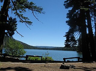
Suttle Lake is a natural lake near the crest of the Cascade Range in central Oregon, United States, covering 253 acres (1.02 km2). It was named in honor of John Settle, whose name was misspelled when the lake was officially recorded as a geographic feature. Today, the lake is located within the Deschutes National Forest and serves as one of central Oregon's most popular outdoor recreation sites, with three large campgrounds and two day-use areas along the north, west, and south shores of the lake. The Oregon Department of Fish and Wildlife regularly stocks the lake with rainbow trout.
Todd Lake is a natural lake near the crest of the Cascade Range in central Oregon in the United States. The lake covers 45 acres (18 ha). It is named in honor of John Y. Todd, an early settler in Central Oregon. Today, the lake and surrounding forest is managed by the United States Forest Service as part of the Deschutes National Forest. The Oregon Department of Fish and Wildlife regularly stocks the lake with brook trout. There is a day-use area and a rustic campground located on the west shore of the lake. In the summer, Todd Lake is a popular outdoor recreation site for picnicking, fishing, hiking, and nature viewing. In the winter, trails in the Todd Lake area are used for cross-country skiing and snowshoeing.

The Elk Lake Guard Station is a United States Forest Service cabin located in the Deschutes National Forest southwest of Bend, Oregon. The guard station was built in 1929 on the north shore of Elk Lake. It was used as a home base for Forest Service personnel who protected forest resources, maintained facilities, and aided summer visitors in the Cascade Lakes area of Central Oregon. After decades of use, the cabin was renovated in the late 1990s. Today, the historic guard station serves as a Forest Service visitor information center along the Cascade Lakes Scenic Byway. The Elk Lake Guard Station is listed on the National Register of Historic Places.

Leslie Allen Joslin is an American retired naval officer, natural resource manager, educator, and author. After serving twenty-two years in the United States Navy, Joslin retired in Oregon where he worked for the United States Forest Service. He also taught college courses at Central Oregon Community College and Oregon State University. Joslin has written or edited eleven books, most of them related in some way to the Forest Service or the state of Oregon. He is also a well-known lecturer on forest resources and central Oregon history topics.

