
The Great Trek was a northward migration of Dutch-speaking settlers who travelled by wagon trains from the Cape Colony into the interior of modern South Africa from 1836 onwards, seeking to live beyond the Cape's British colonial administration. The Great Trek resulted from the culmination of tensions between rural descendants of the Cape's original European settlers, known collectively as Boers, and the British Empire. It was also reflective of an increasingly common trend among individual Boer communities to pursue an isolationist and semi-nomadic lifestyle away from the developing administrative complexities in Cape Town. Boers who took part in the Great Trek identified themselves as voortrekkers, meaning "pioneers", "pathfinders" in Dutch and Afrikaans.

The Province of the Transvaal, commonly referred to as the Transvaal, was a province of South Africa from 1910 until 1994, when a new constitution subdivided it following the end of apartheid. The name "Transvaal" refers to the province's geographical location to the north of the Vaal River. Its capital was Pretoria, which was also the country's executive capital.

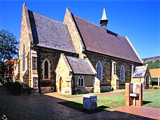
The Boer republics were independent, self-governing republics formed by Dutch-speaking inhabitants of the Cape Colony and their descendants. The founders – variously named Trekboers, Boers, and Voortrekkers – settled mainly in the middle, northern, north-eastern and eastern parts of present-day South Africa. Two of the Boer republics achieved international recognition and complete independence: the South African Republic and the Orange Free State. The republics did not provide for the separation of church and state, initially allowing only the Dutch Reformed Church, and later also other Protestant churches in the Calvinist tradition. The republics came to an end after the Second Boer War of 1899–1902, which resulted in British annexation and later incorporation of their lands into the Union of South Africa.
Pietermaritzburg (; is the capital and second-largest city in the province of KwaZulu-Natal, South Africa after Durban. It was named in 1838 and is currently governed by the Msunduzi Local Municipality. The town was named after King Dingane's royal homestead uMgungundlovu. Pietermaritzburg is popularly called Maritzburg in Afrikaans and is often informally abbreviated to PMB. It is a regionally important industrial hub, producing aluminium, timber and dairy products, as well as the main economic hub of uMgungundlovu District Municipality. The public sector is a major employer in the city due to local, district and provincial government offices located here.
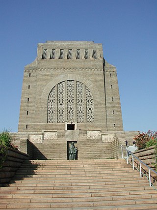
The Voortrekker Monument is located just south of Pretoria in South Africa. The granite structure is located on a hilltop, and was raised to commemorate the Voortrekkers who left the Cape Colony between 1835 and 1854. It was designed by the architect Gerard Moerdijk.

Joachim Johannes Ferreira was a Boer commandant of the First Boer War. This general J. Ferreira should not be confused with general I. Ferreira.

The Natalia Republic was a short-lived Boer republic founded in 1839 after a Voortrekker victory against the Zulus at the Battle of Blood River. The area was previously named Natália by Portuguese sailors, due to its discovery on Christmas. The republic came to an end in 1843 when British forces annexed it to form the Colony of Natal. After the British annexation of the Natalia Republic, most local Voortrekkers trekked northwest into Transorangia, later known as the Orange Free State, and the South African Republic.

The Weenen massacre was the massacre of Khoikhoi, Basuto and Voortrekkers by the Zulu Kingdom on 17 February 1838. The massacres occurred at Doringkop, Bloukrans River, Moordspruit, Rensburgspruit and other sites around the present day town of Weenen in South Africa's KwaZulu-Natal province.

Lydenburg, also known as Mashishing, is a town in Thaba Chweu Local Municipality, on the Mpumalanga highveld, South Africa. It is situated on the Sterkspruit/Dorps River tributary of the Lepelle River at the summit of the Long Tom Pass. It has a long, rich history, ranging from AD 500 to the present. The name is derived from the Dutch Lijdenburg, or "Town of Suffering", and is named for the experiences of the white settlers. In Northern Sotho, Mashishing means "long green grass." Lydenburg has become the centre of the South African fly-fishing industry and is an agricultural, tourism and mining hub.

Paulpietersburg is a small town in KwaZulu-Natal, South Africa. It was established in 1888 and was then part of the Transvaal Republic. It was named after then President Paul Kruger and Voortrekker hero Piet Joubert.

Winburg is a small mixed farming town in the Free State province of South Africa.
Amsterdam, is a small town located in Mkhondo Local Municipality, Mpumalanga South Africa. Amsterdam encompasses a large Swazi population as a result of its proximity to the Eswatini border which is relatively close to the area. The town is located some 77 km east of Ermelo. There are large plantations of gum, pine and wattle trees in the area. The town also boasts of a peaceful community with rich culture and heritage.

Ermelo is the educational, industrial and commercial town of the 7,750 km2 Gert Sibande District Municipality in Mpumalanga province, Republic of South Africa. It is both a mixed agriculture and mining region. It is located 210 km east of Johannesburg.
Wakkerstroom is the second oldest town in Mpumalanga province, South Africa. The town is on the KwaZulu-Natal border, 27 km east of Volksrust and 56 km south-east of Amersfoort.
The following lists events that happened during 1838 in South Africa.

Pieter Mauritz Retief was a Voortrekker leader. Settling in 1814 in the frontier region of the Cape Colony, he later assumed command of punitive expeditions during the sixth Xhosa War. He became a spokesperson for the frontier farmers who voiced their discontent, and wrote the Voortrekkers' declaration at their departure from the colony.

The Zulu Kingdom, sometimes referred to as the Zulu Empire or the Kingdom of Zululand, was a monarchy in Southern Africa. During the 1810s, Shaka established a standing army that consolidated rival clans and built a large following which ruled a wide expanse of Southern Africa that extended along the coast of the Indian Ocean from the Tugela River in the south to the Pongola River in the north.

Mkhondo Municipality is a local municipality within the Gert Sibande District Municipality, in the Mpumalanga province of South Africa. Piet Retief is the seat of the municipality.

Piet Retief Commando was a light infantry regiment of the South African Army. It formed part of the South African Army Infantry Formation as well as the South African Territorial Reserve.
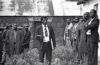
Saul Mkhize was a South African human rights activist and representative for the people of Driefontein, Mpumalanga who were fighting against forceful removals from their land by the apartheid government. Mkhize was shot down by the police while organising a peaceful march.


