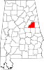
Clay County is a county of the U.S. state of Alabama. As of the 2010 census the population was 13,932. Its county seat is Ashland. Its name is in honor of Henry Clay, famous American statesman, member of the United States Senate from Kentucky and United States Secretary of State in the 19th century. It was the last dry county in Alabama with no wet cities within its boundaries, until a vote on March 1, 2016 approved the sale of alcohol in Lineville and Ashland.

Union County is a county located in the U.S. state of South Carolina. As of the 2010 census, the population was 28,961. Its county seat is Union. The county was created in 1785.

Perry County is a county located in the U.S. state of Illinois. According to the 2010 census, it had a population of 22,350. Its county seat is Pinckneyville. It is located in the southern portion of Illinois known locally as "Little Egypt".
Pinckneyville is a city in and the county seat of Perry County, Illinois, United States. The population was 5,648 at the 2010 census. It is named for Charles Cotesworth Pinckney, an early American diplomat and presidential candidate.

Notre Dame is a census-designated place north of the city of South Bend in St. Joseph County, in the U.S. state of Indiana. It includes the campuses of three colleges: the University of Notre Dame, Saint Mary's College, and Holy Cross College. Notre Dame is split between Clay and Portage Townships. As of the 2010 census, its population was 5,973.

Cedarbluff is an unincorporated community in Clay County, Mississippi, United States. It is located in south central Clay County along Mississippi Highway 50.

Billtown is an unincorporated community in Posey Township, Clay County, Indiana. It is part of the Terre Haute Metropolitan Statistical Area.

Pyatts is an unincorporated community in Perry County, Illinois, United States. Pyatts is 5 miles (8.0 km) south of Pinckneyville.
Todds Mill is an unincorporated community in Perry County, Illinois, United States. Todds Mill is 8.5 miles (13.7 km) north of Pinckneyville.
Conant is an unincorporated community in Perry County, Illinois, United States. Conant is 5.5 miles (8.9 km) west-southwest of Pinckneyville.
Winkle is an unincorporated community in Perry County, Illinois, United States. Winkle is 7.5 miles (12.1 km) northwest of Pinckneyville.
Denny is an unincorporated community in Perry County, Illinois, United States. Denny is 4 miles (6.4 km) southeast of Pinckneyville.

Cherryvale is an unincorporated community in Vigo and Clay counties, in the U.S. state of Indiana.
Pinckneyville is an unincorporated community in Wilkinson County, Mississippi. Its elevation is 239 feet.

Idana is an unincorporated community in Clay County, Kansas, United States. It is located near the town of Clay Center, south of US Route 24.

Calumet is an unincorporated community in Knox Township, Jefferson County, Ohio, United States. It is located just north of Toronto between Ohio State Route 7 and the Ohio River, at 40°28′55″N80°36′24″W. North 4th Street and North River Avenue both run continuously from Toronto to Calumet.
Layfield is an unincorporated community in Perry County, Illinois, United States. The community is located along Illinois Route 13 3.4 miles (5.5 km) northwest of Pinckneyville.
The Perry County Courthouse is a government building in central Pinckneyville, the county seat of Perry County, Illinois, United States. Built in 1850, it is the third courthouse in the county's history, and it has been twice expanded to serve the county's growing needs.
Clay is an unincorporated community in Franklin Township, Jackson County, Ohio, United States. It is located between Jackson and Oak Hill at the intersection of Ohio State Route 93 and Clay Banner Road/Pyro Road.
Banner is an unincorporated community in Franklin Township, Jackson County, Ohio, United States. It is located between Jackson and Oak Hill near the intersection of Clay Banner Road and Franklin Valley Road, at 38°56′24″N82°35′42″W.