Pine Gulch Fire

Last updated
Pine Gulch Fire
PineGulchFireAugust102020.jpg
The Pine Gulch Fire as seen from space on August 10, 2020
Date(s)July 31, 2020 (2020-07-31)–September 23, 2020 (2020-09-23)
Location Mesa County & Garfield County, Colorado, United States
Coordinates 39°20′10″N108°31′34″W / 39.336°N 108.526°W / 39.336; -108.526
Statistics [1] [2]
Burned area139,007 acres (56,254 ha)
Land useRecreational
Impacts
Non-fatal injuries3 firefighters
Structures destroyed1 outbuilding
Ignition
Cause Lightning strike
Map
USA Colorado location map.svg
FireIcon.svg
Location of Pine Gulch Fire in Colorado

The Pine Gulch Fire was a wildfire that burned in Mesa County and Garfield County, Colorado in the United States. The fire was started by a lightning strike and first reported on July 31, 2020 and quickly grew, resulting in the fire being named the largest wildfire in Colorado history, surpassing the 2002 Hayman Fire. [3] Almost seven weeks later, it was surpassed by the Cameron Peak Fire in Larimer County. [4] [1]

Contents

The Pine Gulch Fire burned on private and public lands and threatened gas and oil drilling infrastructure. The fire resulted in the closure of highways, government-managed and recreational land, and the evacuation of rural residences in the fire zone. The fire was declared 100% contained on September 23, and all evacuation orders were lifted. In total, the fire burned 139,007 acres (56,254 ha). [1]

Events

July

The Pine Gulch Fire was first reported on July 31, 2020, around 5:15 PM, in a remote area of Bureau of Land Management (BLM) land in Mesa County, Colorado, approximately eighteen miles north of Grand Junction. Started by a lightning strike, the fire spread rapidly, fueled by hot weather, steep terrain, and drought stricken grass, sage, pinyon and fir. [1]

August

Burning entirely on BLM land, within 24 hours the Pine Gulch Fire had grown to 280 acres (113 ha). Fire crews were only able to reach the fire area by foot, to build control lines, with the support of helicopters and planes dumping water and retardant. [5] The next day, on August 2, the fire had grown spread north, burning on private land along a road. [6] The fire was five percent contained, at 1,500 acres (607 ha) by the morning of August 3. Mesa County Rd. X 1/2 after High Lonesome Ranch were closed. [7]

The fire continued to grow, threatening oil and gas drilling infrastructure. A temporary flight restriction was put in place for the fire area on August 4. [8] The fire began burning northwards onto Horse Mountain. Air quality began to decline and an Air Quality Health Advisory was put in place for northern Mesa County and southwestern Garfield County. [9] Within 36 hours the fire had grown to 11,846 acres (4,794 ha) by the evening of August 5. [10] Red Flag Warnings were put in place on the 6th and additional road closures were put in place. Smoke began to impact De Beque, Colorado and areas along Interstate 70. [11]

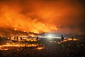
Extremely low humidity, high temperatures and strong winds enabled the fire to grow to over 20,000 acres (8,094 ha) by the evening of August 7. The fire had moved down Forshay Gulch on the north side of Horse Mountain, before eventually spreading to Lion and Bledsaw Gulches and along 200 Rd. [12] The fires continued growth resulted in evacuation warnings being put in place for residents in rural, western Garfield County and a small group of homes were evacuated along County Roads 200 and 202. [13] On August 9, evacuations were put in place for more residences in the area. [14]

A red flag warning was put into place on August 11 and the fire was seven percent contained. The fire began burning in closer to Roan Creek and on the south slope of Kimball Mountain. [15] Red flag winds pushed the fire over 50,000 acres (20,234 ha) on August 11. [16] On August 15, the fire burned onto Garfield Mesa and additional road closures were put in place. The air quality was impacted in Craig and Meeker. [17]

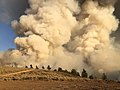
The fire moved north of Fruita, resulting in more road closures. Air tankers began providing support, dumping retardant to slow the fire's spread. [18] On August 18, residents on a portion of Roan Creek Rd were allowed to return to their homes. An evacuation warning was put in place for areas of County Road 205, Kimball Mountain Rd and County Road 256. A thunderstorm moved through the western flank and caused wind gusts up to 40 MPH in near Echo Lake, resulting in firefighters having to evacuate the area due to the fire's erratic behavior and fast spread. This caused the fire to grow to an estimated 125,000 acres (50,586 ha). [19] This growth resulted in additional evacuation orders in Garfield County for residents east of Highway 139 and closures of 639,111 acres (258,639 ha) of BLM land north of Loma, Fruita, Grand Junction and Palisade. [20] [21] [22]

By August 24, the Pine Gulch Fire was 44 percent contained. [23] Two days later, on August 26, Highway 139 reopened. [24] The next day, suppression repair began. A flash flood warning was announced for the eastern portion of the fire due to forecasted thunderstorms. A small debris flow took place near Kimball Creek Rd. [25] On August 28, the fire had burned 139,006 acres (56,254 ha) and was named the largest wildfire in Colorado history. The fire was 77 percent contained. Evacuation warnings were lifted for all areas west of Highway 139 to the Utah border and BLM closures were reduced. [26]

September

On September 1, all evacuation orders were lifted. [27] As of September 3, the fire had burned 139,007 acres (56,254 ha) and was 83 percent contained. [1] By September 9, the fire was 95 percent contained. [28]

Impact

The Pine Gulch Fire resulted in the evacuation of residences, including along Roan Creek (CR 204) Rd. Numerous county roads were closed, as well as a portion of Highway 139. [18]

A natural gas well threatened by the Pine Gulch Fire. The well was stopped from producing gas when the fire started. Natural Gas Wells one of the values at risk on the Pine Gulch Fire 01.jpg
A natural gas well threatened by the Pine Gulch Fire. The well was stopped from producing gas when the fire started.

The Pine Gulch Fire impacted recreation, transportation, and energy infrastructure in the area. The fire resulted in the closure of roads. The fire threatened oil drills and gas wells. [8] This resulted in gas wells being stopped from collecting gas on August 2 and fire crews implementing defensible space around them. [29]

The fire impacted air quality in Garfield, Moffat, Mesa and Rio Blanco Counties, including the communities of Craig and Meeker. [17]

Firefighters sustained minor injuries. [2]

See also

Related Research Articles

<span class="mw-page-title-main">2013 Colorado wildfires</span>

In the summer of 2013, there were several major wildfires in Colorado in the United States. During June and July, record high temperatures and dry conditions fueled the fires all across the state. By July 24, 570 structures had been destroyed and 2 people died. Below is a list of the major fires of the year.

<span class="mw-page-title-main">Soberanes Fire</span> 2016 wildfire in Central California

The Soberanes Fire was a large wildfire that burned from July to October 2016 in the Santa Lucia Mountains of Monterey County, California. It destroyed 57 homes and killed a bulldozer operator, and cost about $260 million to suppress, making it at the time the most expensive wildfire to fight in United States history. At the fire's peak, over 5,000 personnel were assigned to the blaze. The fire was the result of an illegal campfire in Garrapata State Park. By the time it was finally extinguished, the fire had burned 132,127 acres (53,470 ha) along the Big Sur coast in the Los Padres National Forest, Ventana Wilderness, and adjacent private and public land in Monterey County, ranking it 18th on the list of the largest California wildfires in terms of acreage burned.

<span class="mw-page-title-main">Ferguson Fire</span> 2018 wildfire in Central California

The Ferguson Fire was a major wildfire in the Sierra National Forest, Stanislaus National Forest and Yosemite National Park in California in the United States. The fire was reported on July 13, 2018, burning 96,901 acres (392 km2), before it was 100% contained on August 19, 2018. Interior areas of the fire continued to smolder and burn until September 19, 2018, when InciWeb declared the fire to be inactive. The Ferguson Fire was caused by the superheated fragments of a faulty vehicle catalytic converter igniting vegetation. The fire, which burned mostly in inaccessible wildland areas of the national forest, impacted recreational activities in the area, including in Yosemite National Park, where Yosemite Valley and Wawona were closed. The Ferguson Fire caused at least $171.2 million in damages, with a suppression cost of $118.5 million and economic losses measuring $52.7 million. Two firefighters were killed and nineteen others were injured in the fire.

<span class="mw-page-title-main">Taboose Fire</span> 2019 wildfire in Eastern California

The Taboose Fire was a wildfire burning in Inyo National Forest, southwest of Big Pine and northwest of Aberdeen in Inyo County in the state of California, in the United States. The fire started September 4, 2019 and on October 7, it had burned 10,296 acres (4,167 ha) and was 75 percent contained. The cause of the fire was lightning. Select trails, campgrounds and roads in Inyo National Forest, Sequoia National Park and Kings Canyon National Park had been closed due to the fire. The community of Baxter Ranch was under mandatory evacuation.

<span class="mw-page-title-main">Lime Fire</span> 2019 wildfire in Northern California

The Lime Fire was a wildfire located west of Interstate 5 and north of Highway 96 in the Klamath National Forest's Lime Gulch area in Siskiyou County. The fire was started as the result of a lightning strike during a thunderstorm. As of September 17, the fire has burned 1,862 acres (754 ha) and is 96 percent contained. Evacuation warnings are in place for the area between Ash Creek and Gottsville, warning to take "extreme caution" along Highway 96. Portions of Klamath National Forest are closed due to the fire.

<span class="mw-page-title-main">Mangum Fire</span> 2020 Arizona wildfire

The Mangum Fire was a wildfire in Kaibab National Forest in Arizona in the United States. The fire, which started on June 8, 2020 approximately 16 miles north of the North Rim of Grand Canyon National Park, burned a total of 71,450 acres (28,915 ha). The fire threatened the community of Jacob Lake, Arizona, resulting in its evacuation. Select highways were closed, including Highway 67, which resulted in closure of the North Rim of the Grand Canyon. Additionally, areas of the Paria Canyon-Vermilion Cliffs Wilderness were inaccessible due to closures. Four buildings were destroyed, including two historic cabins. The exact cause of the fire remains under investigation, however, fire officials have confirmed it was human caused.

<span class="mw-page-title-main">East Canyon Fire</span>

The East Canyon Fire was a wildfire burning in La Plata and Montezuma Counties in Colorado in the United States. The fire was the largest of many small fires started by a lightning storm and was first reported on June 14, 2020. The East Canyon Fire burned 2,905 acres (1,176 ha) and was contained on June 27, 2020. The fire resulted in the closure a portion of Highway 160 and mandatory evacuations of a campground and residences in the area.

<span class="mw-page-title-main">Lump Gulch Fire</span>

The Lump Gulch Fire was a wildfire that burned in Jefferson County in the state of Montana in the United States. The fire, which was first reported on June 13, 2020, was started by a downed power line. It burned in the Lewis and Clark National Forest, Helena National Forest, and on state and private land. As of June 23, the fire had burned 1,079 acres (437 ha) and was 85 percent contained. Two outbuildings were destroyed by the fire and select areas on National Forest land were closed due to the fire.

<span class="mw-page-title-main">Central Fire (Arizona)</span> 2020 wildfire in Maricopa County, Arizona

The Central Fire was a wildfire that burned in Tonto National Forest in Maricopa County, Arizona in the United States. The fire, which was first reported on June 20, 2020, burned a total of 4,499 acres (1,821 ha). It was contained on June 30, 2020 and was human caused.

<span class="mw-page-title-main">Canal Fire</span>

The Canal Fire was a wildfire that burned Millard County in Utah in the United States. First reported on June 26, 2020, the fire burned 78,065 acres (31,592 ha) on public land, including Fishlake National Forest and land owned by the Bureau of Land Management. Started by a lightning strike, the fire was contained on June 27, only to escape containment on June 28 due to strong winds. The fire led to the mandatory evacuation of Fool Creek Peak and Leamington, Utah. It was contained on July 11, 2020.

<span class="mw-page-title-main">Numbers Fire</span>

The Numbers Fire was a wildfire that burned in the Pine Nut Mountains, near Gardnerville, Nevada, in the United States. The fire was reported on July 6, 2020, and burned 18,342 acres (7,423 ha). It was contained on July 14, 2020. The fire threatened the communities of Ruhenstroth, Pine View Estates and Bodie Flats, totaling approximately 1,000 homes. It resulted in the mandatory evacuations of Pine View Estates and Bodie Flats and the closure of a 15-mile stretch of Highway 395. Forty structures were destroyed, including three homes. The fire was started by a truck with mechanical issues which discharged particles which ignited the fire.

<span class="mw-page-title-main">Grizzly Creek Fire</span>

The Grizzly Creek Fire was a wildfire that burned 32,631 acres in Glenwood Canyon in the state of Colorado in the United States. The fire first ignited on August 10, 2020 and was declared 100% contained on December 18, 2020. The Grizzly Creek fire's proximity to Interstate 70 resulted in a 13-day closure of the interstate. It threatened the Shoshone Generating Station and resulted in the evacuation of residences in the area, as well as closure of recreational land in portions of White River National Forest. The fire was ruled to be human-caused.

<span class="mw-page-title-main">Lake Fire (2020)</span> 2020 wildfire in Southern California

The Lake Fire was a wildfire that burned during the 2020 California wildfire season in the Angeles National Forest in Los Angeles County in the state of California in the United States. The fire, which was first reported on August 12, 2020, burned 31,089 acres (12,581 ha) near Lake Hughes. It was fully contained on September 28. The cause of the fire remains unknown. The fire has damaged 3 structures, destroyed 12 structures and 21 outbuildings, and injured 4 firefighters.

<span class="mw-page-title-main">North Complex Fire</span> 2020 wildfire in Northern California

The North Complex Fire was a massive wildfire complex that burned in the Plumas National Forest in Northern California in the counties of Plumas and Butte. 21 fires were started by lightning on August 17, 2020; by September 5, all the individual fires had been put out with the exception of the Claremont and Bear Fires, which merged on that date, and the Sheep Fire, which was then designated a separate incident. On September 8, strong winds caused the Bear/Claremont Fire to explode in size, rapidly spreading to the southwest. On September 8, 2020, the towns of Berry Creek and Feather Falls were immediately evacuated at 3:15 p.m. PDT with no prior warning, By September 9, 2020, the towns of Berry Creek and Feather Falls had been leveled, with few homes left standing. The fire threatened the city of Oroville, before its westward spread was stopped. The fire killed 16 people and injured more than 100. Among the 16 fatalities was a 16-year-old boy. The complex burned an estimated 318,935 acres (129,068 ha), and was 100% contained on December 3. The fire was managed by the U.S. Forest Service in conjunction with Cal Fire, with the primary incident base in Quincy. The North Complex Fire was the sixth-largest in California's modern history, and the deadliest fire in the 2020 California wildfire season.

<span class="mw-page-title-main">2020 Colorado wildfires</span>

The 2020 Colorado wildfire season was a series of significant wildfires that burned throughout the U.S. state of Colorado as part of the 2020 Western United States wildfire season. With a total of 665,454 acres (269,300 ha) burned, and the 3 largest fires in state history, it is Colorado's largest wildfire season on record.

<span class="mw-page-title-main">2020 Lassen County wildfires</span> 2020 wildfire sub-season that burned in Lassen County

The 2020 Lassen County wildfire season included seven large wildfires that burned entirely or in part in Lassen County. A total of 203,296 acres (82,271 ha) of land was burned in Lassen County, making it one of the larger clusters of fires in the 2020 California wildfire season.

<span class="mw-page-title-main">2021 Colorado wildfires</span> Wildfires in the US

The 2021 Colorado wildfire season was a series of wildfires that burned throughout the U.S. state of Colorado. According to the National Interagency Fire Center, as of July 1, 2021, at least 32,860 acres (13,300 ha) of land had burned in at least 337 wildland fires across the state. Hundreds of homes were burned, and the cities of Louisville and Superior were evacuated, during the Boulder County fires in late December.

<span class="mw-page-title-main">McFarland Fire</span> 2021 wildfire in Northern California

The McFarland Fire was a wildfire that burned in the Shasta-Trinity National Forest north of Wildwood in Trinity County, Shasta County, and Tehama County, California in the United States. Started by a lightning strike, the fire was first reported on July 29, 2021 on McFarland Ridge south of Highway 36. As of September 16, 2021, the fire had burned 122,653 acres (49,636 ha) and destroyed 46 structures.

<span class="mw-page-title-main">Antelope Fire</span> 2021 wildfire in California

The Antelope Fire was a wildfire that burned in the Klamath National Forest, the Modoc National Forest, the Shasta-Trinity National Forest, and in Lava Beds National Monument in Siskiyou County, California, in the United States. The fire was started by a lightning strike and was first reported on August 1, 2021. As of October 15, the fire had burned 145,632 acres (58,935 ha).

References

Sources

PD-icon.svg This article incorporates public domain material from the United States Government

Footnotes

  1. 1 2 3 4 5 "Pine Gulch Fire". InciWeb. Retrieved 28 August 2020.
  2. 1 2 "Pine Gulch Fire Update, Sunday, August 29 - InciWeb the Incident Information System". InciWeb. 29 August 2020. Retrieved 31 August 2020.
  3. Flores, Jessica. "Pine Gulch Fire becomes largest wildfire in Colorado history, burning over 217 square miles near Grand Junction". USA Today. Retrieved 28 August 2020.
  4. Kyle, Sarah. "What we know Thursday: Cameron Peak Fire crews face 'critical winds and fire weather'". The Coloradoan. Retrieved 2020-10-15.
  5. "Pine Gulch Fire 280 acres, no containment - InciWeb the Incident Information System". InciWeb. Grand Junction Field Office Bureau of Land Management. 1 August 2020. Retrieved 29 August 2020.
  6. "Pine Gulch Fire 1,020 acres, no containment - InciWeb the Incident Information System". InciWeb. Grand Junction Field Office Bureau of Land Management. 2 August 2020. Retrieved 29 August 2020.
  7. "Type 2 team called in for Pine Gulch Fire - InciWeb the Incident Information System". InciWeb. Grand Junction Field Office Bureau of Land Management. 3 August 2020. Retrieved 29 August 2020.
  8. 1 2 "Pine Gulch Fire Update - 8/4/2020 - InciWeb the Incident Information System". InciWeb. Grand Junction Field Office Bureau of Land Management. 4 August 2020. Retrieved 29 August 2020.
  9. "August 5 Pine Gulch Fire Update - InciWeb the Incident Information System". InciWeb. Grand Junction Field Office Bureau of Land Management. 5 August 2020. Retrieved 29 August 2020.
  10. "August 6 Pine Gulch Fire Update - InciWeb the Incident Information System". InciWeb. Grand Junction Field Office Bureau of Land Management. 6 August 2020. Retrieved 29 August 2020.
  11. "August 7 Pine Gulch Fire Update - InciWeb the Incident Information System". InciWeb. Grand Junction Field Office Bureau of Land Management. 7 August 2020. Retrieved 29 August 2020.
  12. "August 7 Pine Gulch Fire Update - InciWeb the Incident Information System". InciWeb. Grand Junction Field Office Bureau of Land Management. 8 August 2020. Retrieved 29 August 2020.
  13. "Evacuations and pre-evacuations announced by Garfield County Sheriff - InciWeb the Incident Information System". InciWeb. Grand Junction Field Office Bureau of Land Management. 8 August 2020. Retrieved 29 August 2020.
  14. "Pine Gulch Fire Update 8/9/2020 evening - InciWeb the Incident Information System". InciWeb. Grand Junction Field Office Bureau of Land Management. 9 August 2020. Retrieved 29 August 2020.
  15. "August 11 Pine Gulch Fire Update - InciWeb the Incident Information System". InciWeb. 11 August 2020. Retrieved 30 August 2020.
  16. "August 12 Pine Gulch Fire Update - InciWeb the Incident Information System". InciWeb. 12 August 2020. Retrieved 30 August 2020.
  17. 1 2 "Pine Gulch Fire Update, Sunday, August 16 - InciWeb the Incident Information System". InciWeb. 16 August 2020. Retrieved 30 August 2020.
  18. 1 2 "Pine Gulch Fire Update, August 18, Tuesday - InciWeb the Incident Information System". InciWeb. 18 August 2020. Retrieved 30 August 2020.
  19. "Pine Gulch Fire Update, Wednesday, August 19 - InciWeb the Incident Information System". InciWeb. 19 August 2020. Retrieved 30 August 2020.
  20. "Pine Gulch Fire Update, Thursday, August 20 - InciWeb the Incident Information System". InciWeb. 20 August 2020. Retrieved 30 August 2020.
  21. "Pine Gulch Fire Update, Friday, August 21 - InciWeb the Incident Information System". InciWeb. 21 August 2020. Retrieved 30 August 2020.
  22. "Programs: Fire and Aviation: Colorado: Northwest District Fire Restrictions". Bureau of Land Management. 5 June 2019. Retrieved 30 August 2020.
  23. "Pine Gulch Fire Update, Monday, August 24 - InciWeb the Incident Information System". InciWeb. 24 August 2020. Retrieved 31 August 2020.
  24. "Pine Gulch Fire Update, Wednesday, August 26 - InciWeb the Incident Information System". InciWeb. 26 August 2020. Retrieved 31 August 2020.
  25. "Pine Gulch Fire Update, Thursday, August 27 - InciWeb the Incident Information System". InciWeb. 27 August 2020. Retrieved 31 August 2020.
  26. "Pine Gulch Fire Update, Friday, August 28 - InciWeb the Incident Information System". InciWeb. 28 August 2020. Retrieved 31 August 2020.
  27. "Pine Gulch Fire Update September 2, 2020 - InciWeb the Incident Information System". InciWeb. 2 September 2020. Retrieved 3 September 2020.
  28. Grewe, Lindsay (9 September 2020). "Pine Gulch Fire 95 percent contained". KKTV 11. Archived from the original on 14 September 2020. Retrieved 14 September 2020.
  29. "Natural Gas Wells one of the values at risk on the Pine Gulch Fire - InciWeb the Incident Information System". InciWeb. Grand Junction Field Office Bureau of Land Management. 8 August 2020. Retrieved 29 August 2020.