De Beque, Colorado

Last updated

De Beque, Colorado
De Beque, Colorado.JPG
Minter Avenue in De Beque, March 2013
Mesa County Colorado Incorporated and Unincorporated areas De Beque Highlighted 0819355.svg
Location of the Town of De Beque in Mesa County, Colorado.
Usa edcp location map.svg
Red pog.svg
De Beque
Location of the Town of De Beque in the United States.
Coordinates: 39°18′38″N108°12′18″W / 39.31056°N 108.20500°W / 39.31056; -108.20500 [2]
Country Flag of the United States.svg  United States
State Flag of Colorado.svg  Colorado
County Mesa County [1]
Settled 1880
Incorporated January 18, 1890 [3]
Government
  Type Statutory Town [1]
  MayorShanelle Hansen [4]
  Town AdministratorCare' McGinnis
  Chief MarshalRobert Dalley
Area
[5]
  Total2.778 sq mi (7.196 km2)
  Land2.727 sq mi (7.063 km2)
  Water0.051 sq mi (0.133 km2)
Elevation
[2]
4,954 ft (1,510 m)
Population
 (2020) [5]
  Total493
  Density183/sq mi (71/km2)
   Metro
155,703
Time zone UTC−07:00 (MST)
  Summer (DST) UTC−06:00 (MDT)
ZIP code
81630
Area code 970
FIPS code 08-19355
GNIS feature ID 2412412 [2]
Website www.debeque.org

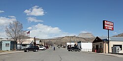
De Beque is a statutory town located in Mesa County, Colorado. [1] The population was 493 at the time of the 2020 census. [5] De Beque is a part of the Grand Junction, CO Metropolitan Statistical Area. The town consists of a small grid, including a historic downtown featuring a town hall, a tavern, and several commercial businesses in historic structures. The surrounding streets include houses, several churches, and a school.

Contents

History

The town is located in a region historically occupied by the Ute people. [6] White settlers arrived in the region in 1880. [6]

The town is named after Dr. W.A.E. de Beque [7] who explored the area with several companions in 1884 while looking for a suitable location for a ranch.

The town was historically a location where wild horses, prevalent in the surrounding lands, were rounded up and sold. [8] The history of the town is commemorated with a mustang statue near the town hall. In August 2001, the Town Board of Trustees designated De Beque as the only Wild Horse Sanctuary City in the West. [9] The town now undertakes projects in cooperation with the Bureau of Land Management, as well as private organizations, to protect the remaining wild horses in the area. There are no burros in western Colorado. Such measures include the construction of a public corral for the care of injured and sick mustangs awaiting adoption. [8]

On April 1, 2014, De Beque became the first incorporated town in Mesa County to approve the retail sale of recreational marijuana. [10]

Geography

The town sits along the north side of the Colorado River upstream from De Beque Canyon in a small ranching valley approximately 25 miles (40 km) northeast and upstream from Grand Junction. It is located across the river from Interstate 70, on a small hill overlooking the river. The southwest edge of the Roan Cliffs overlook the town from the northeast. Much of the surrounding area in the mountains is controlled by the Bureau of Land Management. Mount Logan can be seen from town, five miles to the north.

At the 2020 United States Census, the town had a total area of 1,778 acres (7.196 km2) including 33 acres (0.133 km2) of water. [5]

Demographics

Historical population
CensusPop.Note
1900 83
1910 14979.5%
1920 29296.0%
1930 34718.8%
1940 280−19.3%
1950 253−9.6%
1960 172−32.0%
1970 155−9.9%
1980 27980.0%
1990 257−7.9%
2000 45175.5%
2010 50411.8%
2020 493−2.2%
U.S. Decennial Census

As of the census [11] of 2000, there were 451 people, 167 households, and 130 families residing in the town. The population density was 1,411.7 inhabitants per square mile (545.1/km2). There were 188 housing units at an average density of 588.5 per square mile (227.2/km2). The racial makeup of the town was 98.45% White, 0.67% Native American, 0.89% from other races. Hispanic or Latino of any race were 2.00% of the population.

There were 167 households, out of which 37.7% had children under the age of 18 living with them, 61.1% were married couples living together, 12.6% had a female householder with no husband present, and 21.6% were non-families. 18.0% of all households were made up of individuals, and 7.8% had someone living alone who was 65 years of age or older. The average household size was 2.70 and the average family size was 3.05.

In the town, the population was spread out, with 30.6% under the age of 18, 8.2% from 18 to 24, 25.9% from 25 to 44, 21.3% from 45 to 64, and 14.0% who were 65 years of age or older. The median age was 34 years. For every 100 females, there were 99.6 males. For every 100 females age 18 and over, there were 94.4 males.

The median income for a household in the town was $29,632, and the median income for a family was $31,042. Males had a median income of $28,750 versus $17,500 for females. The per capita income for the town was $14,181. About 6.2% of families and 7.3% of the population were below the poverty line, including 9.8% of those under age 18 and 3.8% of those age 65 or over.

Art and Culture

Wild Horse Days

The town has hosted "Wild Horse Day" every August since 2000. The festival includes a rodeo and parade.

The festival was originally begun to promote awareness to the wild horse population and raise funds for a corral and rodeo grounds. [12]

See also

Related Research Articles

<span class="mw-page-title-main">San Juan County, New Mexico</span> County in New Mexico, United States

San Juan County is located in the U.S. state of New Mexico. As of the 2020 census, the population was 121,661 making it the fifth-most populous county in New Mexico. Its county seat is Aztec. The county was created in 1887.

<span class="mw-page-title-main">Saguache County, Colorado</span> County in Colorado, United States

Saguache County is a county located in the U.S. state of Colorado. As of the 2020 census, the population was 6,368. The county seat is Saguache.

<span class="mw-page-title-main">Montrose County, Colorado</span> County in Colorado, United States

Montrose County is a county located in the U.S. state of Colorado. As of the 2020 census, the population was 42,679. The county seat is Montrose, for which the county is named.

<span class="mw-page-title-main">Montezuma County, Colorado</span> County in Colorado, United States

Montezuma County is a county located in the southwest corner of the U.S. state of Colorado. As of the 2020 census, the population was 25,849. The county seat is Cortez.

<span class="mw-page-title-main">Cheyenne County, Colorado</span> County in Colorado, United States

Cheyenne County is a county located in the U.S. state of Colorado. The county population was 1,748 at 2020 census. The county seat is Cheyenne Wells.

<span class="mw-page-title-main">Rodeo, California</span> Census-designated place in California, United States

Rodeo is a census-designated place (CDP) located in Contra Costa County, California, in the East Bay sub-region of the San Francisco Bay Area, on the eastern shore of San Pablo Bay, 25 miles northeast of San Francisco. The population was 9,653 at the 2020 census. The town is named for the rodeos common in the late 19th century. Cattle from the surrounding hills were regularly driven down through the old town to a loading dock on the shoreline of San Pablo Bay for shipment to slaughterhouses, a practice which continued through the early 20th century. The town of Rodeo is served by the Interstate 80 freeway and State Route 4. The Southern Pacific Railroad main line passes through Rodeo. Rodeo has not been a stop on the railroad since the 1950s.

<span class="mw-page-title-main">Deer Trail, Colorado</span> Town in Colorado, United States

The Town of Deer Trail is a Statutory Town located in eastern Arapahoe County, Colorado, United States. The town population was 1,068 at the 2020 United States Census, a +95.60% increase since the 2010 United States Census. Deer Trail is a part of the Denver–Aurora–Lakewood, CO Metropolitan Statistical Area and the Front Range Urban Corridor. The town is situated along Interstate 70, approximately 55 miles (89 km) east of Denver.

<span class="mw-page-title-main">Carbondale, Colorado</span> Town in Colorado, United States

The Town of Carbondale is a home rule municipality located in Garfield County, Colorado, United States. The town population was 6,434 at the 2020 United States Census. Carbondale is a part of the Glenwood Springs, CO Micropolitan Statistical Area.

<span class="mw-page-title-main">Rifle, Colorado</span> City in Colorado, United States

Rifle is a home rule municipality in and the most populous community of Garfield County, Colorado, United States. The population was 10,437 at the 2020 census. Rifle is a regional center of the cattle ranching industry located along Interstate 70 and the Colorado River just east of the Roan Plateau, which dominates the western skyline of the town. The town was founded in 1882 by Abram Maxfield, and was incorporated in 1905 along Rifle Creek, near its mouth on the Colorado. The community takes its name from the creek.

<span class="mw-page-title-main">Brush, Colorado</span> City in Colorado, United States

Brush is a Statutory City located in Morgan County, Colorado, United States. The city population was 5,339 at the 2020 United States Census. Brush is a part of the Fort Morgan, CO Micropolitan Statistical Area.

<span class="mw-page-title-main">Hayden, Colorado</span> Town in Colorado, United States

The Town of Hayden is a home rule municipality located in Routt County, Colorado, United States. The town population was 1,941 at the 2020 United States Census. Hayden is a part of the Steamboat Springs, CO Micropolitan Statistical Area. The town sits along U.S. Highway 40 in the Yampa River Valley between Craig and Steamboat Springs. Hayden is located near the Yampa Valley Regional Airport, by which Hayden is one of the smallest communities in the U.S. to have mainline passenger jet service provided by American Airlines, Delta Air Lines, Southwest Airlines and United Airlines on a scheduled basis.

<span class="mw-page-title-main">Edgewood, Iowa</span> City in Iowa, United States

Edgewood is a city in Clayton and Delaware counties in the U.S. state of Iowa. Highway 3, which runs through the center of town, is the dividing line between the two counties. The Edgewood post office was established in 1852 on the Clayton side of the town. Edgewood was formally incorporated in 1892, although it had a functioning council for some time before that date. The population was 909 at the time of the 2020 census, down from 923 in 2000.

<span class="mw-page-title-main">Charter Oak, Iowa</span> City in Iowa, United States

Charter Oak is a city in Crawford County, Iowa, United States, along the East Soldier River. The population was 535 at the 2020 census.

<span class="mw-page-title-main">Dayton, Iowa</span> City in Iowa, United States

Dayton is a city in Webster County, Iowa, United States. The population was 772 at the time of the 2020 census.

<span class="mw-page-title-main">Abbyville, Kansas</span> City in Reno County, Kansas

Abbyville is a city in Reno County, Kansas, United States. As of the 2020 census, the population of the city was 83.

<span class="mw-page-title-main">Ponca, Nebraska</span> City in and county seat of Dixon County, Nebraska, U.S.

Ponca is a city and county seat of Dixon County, Nebraska, United States. The population was 961 at the 2010 census.

<span class="mw-page-title-main">Mustang, Oklahoma</span> City in Oklahoma, United States

Mustang is a city in the southeastern corner of Canadian County, Oklahoma, United States. It is part of the Oklahoma City metropolitan statistical area. Mustang's population was 19,879 at the 2020 census, a 14.3% increase from 17,398 in 2010. The city is now primarily known as a bedroom community for Oklahoma City.

<span class="mw-page-title-main">Pawnee, Oklahoma</span> City in Oklahoma, United States

Pawnee is a city and county seat of Pawnee County, Oklahoma, United States. The town is northeast of Stillwater at the junction of U.S. Route 64 and State Highway 18.

<span class="mw-page-title-main">Clear Lake, South Dakota</span> City in South Dakota, United States

Clear Lake is a city in and the county seat of Deuel County, South Dakota, United States. The population was 1,218 at the 2020 census.

<span class="mw-page-title-main">Chugwater, Wyoming</span> Town in Wyoming, United States

Chugwater is a town in Platte County, Wyoming, United States. As of the 2020 census, the town population was 175. The High Plains town, located 45 miles north of Cheyenne and 25 miles south of Wheatland.

References

  1. 1 2 3 4 "Active Colorado Municipalities". Colorado Department of Local Affairs . Retrieved October 15, 2021.
  2. 1 2 3 U.S. Geological Survey Geographic Names Information System: De Beque, Colorado
  3. "Colorado Municipal Incorporations". State of Colorado, Department of Personnel & Administration, Colorado State Archives. December 1, 2004. Retrieved September 2, 2007.
  4. "BOARD OF TRUSTEES". Archived from the original on February 7, 2012. Retrieved September 6, 2007.
  5. 1 2 3 4 "Decennial Census P.L. 94-171 Redistricting Data". United States Census Bureau, United States Department of Commerce. August 12, 2021. Retrieved September 7, 2021.
  6. 1 2 "History". Town of De Beque, Colorado. Archived from the original on July 28, 2012. Retrieved July 25, 2012.
  7. Dawson, John Frank. Place names in Colorado: why 700 communities were so named, 150 of Spanish or Indian origin. Denver, CO: The J. Frank Dawson Publishing Co. p. 17.
  8. 1 2 "The Wild Horses of Ute Country". News From Indian Country. Retrieved July 9, 2012.
  9. "DE BEQUE WILD HORSE DAYS". Town of De Beque, Colorado. Archived from the original on October 26, 2011. Retrieved July 25, 2012.
  10. The Daily Sentinel, Tuesday, April 1 De Beque approves retail pot; Fruita declines
  11. "U.S. Census website". United States Census Bureau . Retrieved January 31, 2008.
  12. "Wild Horse Days Come To An End Organizers Have Decided To Cancel The Event". KJCT8.com. Retrieved September 7, 2012.