Ashe County is a county located in the U.S. state of North Carolina. As of the 2010 census, the population was 27,281. Its county seat is Jefferson.

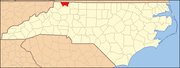
Alleghany County is a county located in the U.S. state of North Carolina. As of the 2010 census, the population was 11,155. Its county seat is Sparta.
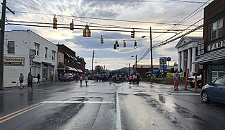
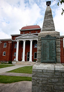
Sparta is a town in Alleghany County, North Carolina, United States. At the last 2010 census, the population was 1,770 people. It is the county seat of Alleghany County.
Boomer is a farming community located in Wilkes County, North Carolina. Legally it is a township, a non-governmental county subdivision. The population was 2,286 at the 2010 Census. The community was named after its first postmaster, Ed "Boomer" Matheson. The community was originally called Warrior Creek, after a stream which flows through the area. Boomer was the birthplace and home of James Larkin Pearson, a poet and newspaper publisher who served as North Carolina Poet Laureate from 1953 to 1981.

Stewarts Creek Township is one of fifteen townships in Surry County, North Carolina. The township had a population of 5,653 according to the 2000 census.

Deep Creek Township is one of twelve townships in Yadkin County, North Carolina, United States. The township had a population of 2,838 according to the 2000 census.

Belews Creek Township is one of fifteen townships in Forsyth County, North Carolina, United States. The township had a population of 2,647 according to the 2010 census.
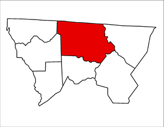
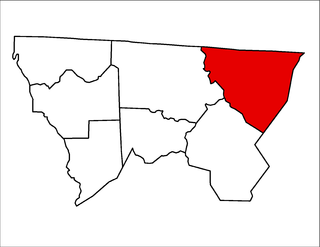
Gap Civil Township is one of seven townships in Alleghany County, North Carolina, United States. The township had a population of 4,474 according to the 2010 census.

Cherry Lane Township is one of seven townships in Alleghany County, North Carolina, United States. The township had a population of 1,528 according to the 2010 census.
Cherry Lane is an unincorporated community located in the Cherry Lane Township of Alleghany County, North Carolina. The community was settled around 1838 and was named for the cherry tree-bordered lane that led to the home of local resident Frank Bryan. The community is located along US Highway 21 near its junction with the Blue Ridge Parkway in southeastern Alleghany County.
Cranberry Township is one of seven townships in Alleghany County, North Carolina, United States. The township had a population of 375, according to the 2010 census. Before 1880, it was included in Prathers Creek Township.
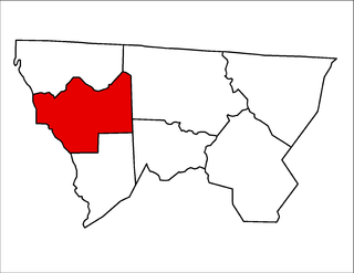
Glade Creek Township is one of seven townships in Alleghany County, North Carolina, United States. The township had a population of 1,991 according to the 2010 census.
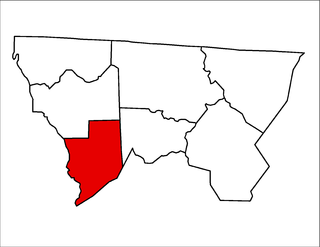
Prathers Creek Township is one of seven townships in Alleghany County, North Carolina, United States. The township had a population of 869 according to the 2010 census. Before 1880, it included Cranberry Township.

Whitehead Township is one of seven townships in Alleghany County, North Carolina, United States. The township had a population of 1,060 according to the 2010 census.

Roaring Gap is an unincorporated community in the Cherry Lane Township of Alleghany County, North Carolina near the border with Wilkes County. Home to three private golf communities, Roaring Gap is a popular summer colony.
Big Creek Township is one of nine townships in Stokes County, North Carolina, United States. The township had a population of 1,984 according to the 2000 census.

Hectors Creek Township is one of thirteen townships in Harnett County, North Carolina, United States. The township had a population of 3,629 according to the 2000 census. It is a part of the Dunn Micropolitan Area, which is also a part of the greater Raleigh–Durham–Cary Combined Statistical Area (CSA) as defined by the United States Census Bureau.
Piney Creek is an unincorporated community located in Piney Creek Township, Alleghany County, North Carolina, United States.

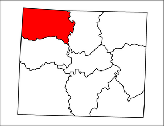
Grassy Creek Township is one of nineteen townships in Ashe County, North Carolina, United States. The township had a population of 455 as of the 2010 census.
Grassy Creek is an unincorporated community in the Grassy Creek Township of Ashe County, North Carolina near the border with the state of Virginia.