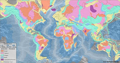
Platform (geology)

Last updated
Geologic provinces of the world (USGS)
.mw-parser-output .legend{page-break-inside:avoid;break-inside:avoid-column}.mw-parser-output .legend-color{display:inline-block;min-width:1.25em;height:1.25em;line-height:1.25;margin:1px 0;text-align:center;border:1px solid black;background-color:transparent;color:black}.mw-parser-output .legend-text{}
Shield
Platform
Orogen
Basin
Large igneous province
Extended crust
Oceanic crust:
0-20 Ma
20-65 Ma
>65 Ma World geologic provinces.jpg
Geologic provinces of the world (USGS)

In geology, a platform is a continental area covered by relatively flat or gently tilted, mainly sedimentary strata, which overlie a basement of consolidated igneous or metamorphic rocks of an earlier deformation. Platforms, shields and the basement rocks together constitute cratons. [1] Platform sediments can be classified into the following groups: a "protoplatform" of metamorphosed sediments at the bottom, a "quasiplatform" of slightly deformed sediments, a "cataplatform", and an "orthoplatform" at the top. The Mesoproterozoic Jotnian sediments of the Baltic area are examples of a "quasiplatform". [2] The post-Ordovician rocks of the South American Platform are examples of an orthoplatform. [3]

See also

Related Research Articles

<span class="mw-page-title-main">Canadian Shield</span> Geographic and geologic area of North America

The Canadian Shield, also called the Laurentian Plateau, is a geologic shield, a large area of exposed Precambrian igneous and high-grade metamorphic rocks. It forms the North American Craton, the ancient geologic core of the North American continent. Glaciation has left the area with only a thin layer of soil, through which exposures of igneous bedrock resulting from its long volcanic history are frequently visible. As a deep, common, joined bedrock region in eastern and central Canada, the Shield stretches north from the Great Lakes to the Arctic Ocean, covering over half of Canada and most of Greenland; it also extends south into the northern reaches of the United States.

<span class="mw-page-title-main">Baltic Shield</span> Ancient segment of Earths crust

The Baltic Shield is a segment of the Earth's crust belonging to the East European Craton, representing a large part of Fennoscandia, northwestern Russia and the northern Baltic Sea. It is composed mostly of Archean and Proterozoic gneisses and greenstone which have undergone numerous deformations through tectonic activity. It contains the oldest rocks of the European continent with a thickness of 250–300 km.

<span class="mw-page-title-main">Interior Plains</span> Physiographic and geologic region of the United States and Canada

The Interior Plains is a vast physiographic region that spreads across the Laurentian craton of central North America, extending along the east flank of the Rocky Mountains from the Gulf Coast region to the Arctic Beaufort Sea. In Canada, it encompasses the Canadian Prairies separating the Canadian Rockies from the Canadian Shield, as well as the Boreal Plains and Taiga Plains east of the Mackenzie and Richardson Mountains; while in the United States, it includes the Great Plains of the West/Midwest and the tallgrass prairie region to the south of the Great Lakes extending east to the Appalachian Plateau region.

<span class="mw-page-title-main">Shield (geology)</span> Large stable area of exposed Precambrian crystalline rock

A shield is a large area of exposed Precambrian crystalline igneous and high-grade metamorphic rocks that form tectonically stable areas. These rocks are older than 570 million years and sometimes date back to around 2 to 3.5 billion years. They have been little affected by tectonic events following the end of the Precambrian, and are relatively flat regions where mountain building, faulting, and other tectonic processes are minor, compared with the activity at their margins and between tectonic plates. Shields occur on all continents.

<span class="mw-page-title-main">Greenstone belt</span> Zone of variably metamorphosed rocks occurring in Archaean and Proterozoic cratons

Greenstone belts are zones of variably metamorphosed mafic to ultramafic volcanic sequences with associated sedimentary rocks that occur within Archaean and Proterozoic cratons between granite and gneiss bodies.

<span class="mw-page-title-main">Geology of India</span> Geological origins and structure of India

The geology of India is diverse. Different regions of India contain rocks belonging to different geologic periods, dating as far back as the Eoarchean Era. Some of the rocks are very deformed and altered. Other deposits include recently deposited alluvium that has yet to undergo diagenesis. Mineral deposits of great variety are found in the Indian subcontinent in huge quantities. Even India's fossil record is impressive in which stromatolites, invertebrates, vertebrates and plant fossils are included. India's geographical land area can be classified into the Deccan Traps, Gondwana and Vindhyan.

<span class="mw-page-title-main">Geology of Australia</span> Overview of the geology of Australia

The geology of Australia includes virtually all known rock types, spanning a geological time period of over 3.8 billion years, including some of the oldest rocks on earth. Australia is a continent situated on the Indo-Australian Plate.

The Pan-African orogeny was a series of major Neoproterozoic orogenic events which related to the formation of the supercontinents Gondwana and Pannotia about 600 million years ago. This orogeny is also known as the Pan-Gondwanan or Saldanian Orogeny. The Pan-African orogeny and the Grenville orogeny are the largest known systems of orogenies on Earth. The sum of the continental crust formed in the Pan-African orogeny and the Grenville orogeny makes the Neoproterozoic the period of Earth's history that has produced most continental crust.

<span class="mw-page-title-main">Basement (geology)</span> Metamorphic or igneous rocks below a sedimentary platform or cover

In geology, basement and crystalline basement are crystalline rocks lying above the mantle and beneath all other rocks and sediments. They are sometimes exposed at the surface, but often they are buried under miles of rock and sediment. The basement rocks lie below a sedimentary platform or cover, or more generally any rock below sedimentary rocks or sedimentary basins that are metamorphic or igneous in origin. In the same way, the sediments or sedimentary rocks on top of the basement can be called a "cover" or "sedimentary cover".

<span class="mw-page-title-main">East European Craton</span> Geology of Europe

The East European Craton (EEC) is the core of the Baltica proto-plate and consists of three crustal regions/segments: Fennoscandia to the northwest, Volgo-Uralia to the east, and Sarmatia to the south. Fennoscandia includes the Baltic Shield and has a diversified accretionary Archaean and early Proterozoic crust, while Sarmatia has an older Archaean crust. The Volgo-Uralia region has a thick sedimentary cover, however deep drillings have revealed mostly Archaean crust. There are two shields in the East European Craton: the Baltic/Fennoscandian shield and the Ukrainian shield. The Ukrainian Shield and the Voronezh Massif consists of 3.2-3.8 Ga Archaean crust in the southwest and east, and 2.3-2.1 Ga Early Proterozoic orogenic belts.

The West African Craton (WAC) is one of the five cratons of the Precambrian basement rock of Africa that make up the African Plate, the others being the Kalahari craton, Congo craton, Saharan Metacraton and Tanzania Craton. Cratons themselves are tectonically inactive, but can occur near active margins, with the WAC extending across 14 countries in Western Africa, coming together in the late Precambrian and early Palaeozoic eras to form the African continent. It consists of two Archean centers juxtaposed against multiple Paleoproterozoic domains made of greenstone belts, sedimentary basins, regional granitoid-tonalite-trondhjemite-granodiorite (TTG) plutons, and large shear zones. The craton is overlain by Neoproterozoic and younger sedimentary basins. The boundaries of the WAC are predominantly defined by a combination of geophysics and surface geology, with additional constraints by the geochemistry of the region. At one time, volcanic action around the rim of the craton may have contributed to a major global warming event.

<span class="mw-page-title-main">Geology of Russia</span> Overview of the geology of Russia

<span class="mw-page-title-main">Tuareg Shield</span> Geological formation between the West African craton and the Saharan Metacraton in West Africa

The Tuareg Shield is a geological formation lying between the West African craton and the Saharan Metacraton in West Africa. Named after the Tuareg people, it has complex a geology, reflecting the collision between these cratons and later events. The landmass covers parts of Algeria, Niger and Mali.

<span class="mw-page-title-main">Geology of Uruguay</span>

The geology of Uruguay combines areas of Precambrian-aged shield units with a region of volcanic rock erupted during the Cretaceous and copious sedimentary facies the oldest of which date from the Devonian. Big events that have shaped the geology of Uruguay include the Transamazonian orogeny, the breakup of Rodinia and the opening of the South Atlantic.

<span class="mw-page-title-main">Geology of Paraguay</span>

The country of Paraguay lies geologically at the borderzone between several cratons. Due to thick Cenozoic sediment cover and regolith development few outcrops are available in Paraguay. East of Paraguay River Precambrian and Early Paleozoic crystalline basement crop out mainly in the heights of Caapucú and Apa. The geological processes that have shaped Paraguay's bedrock and sedimentary basins are diverse including rifting, marine sedimentation, metamorphism, eruption of flood basalts and alkaline potassic volcanism.

<span class="mw-page-title-main">Geology of North America</span> Overview of the geology of North America

The geology of North America is a subject of regional geology and covers the North American continent, the third-largest in the world. Geologic units and processes are investigated on a large scale to reach a synthesized picture of the geological development of the continent.

<span class="mw-page-title-main">East Antarctic Shield</span> Cratonic rock body which makes up most of the continent Antarctica

The East Antarctic Shield or Craton is a cratonic rock body that covers 10.2 million square kilometers or roughly 73% of the continent of Antarctica. The shield is almost entirely buried by the East Antarctic Ice Sheet that has an average thickness of 2200 meters but reaches up to 4700 meters in some locations. East Antarctica is separated from West Antarctica by the 100–300 kilometer wide Transantarctic Mountains, which span nearly 3,500 kilometers from the Weddell Sea to the Ross Sea. The East Antarctic Shield is then divided into an extensive central craton that occupies most of the continental interior and various other marginal cratons that are exposed along the coast.

The geology of South Africa is highly varied including cratons, greenstone belts, large impact craters as well as orogenic belts. The geology of the country is the base for a large mining sector that extracts gold, diamonds, iron and coal from world-class deposits. The geomorphology of South Africa consists of a high plateau rimmed to west, south and southeast by the Great Escarpment, and the rugged mountains of the Cape Fold Belt. Beyond this there is strip of narrow coastal plain.

<span class="mw-page-title-main">Geology of Germany</span> Overview of the geology of Germany

The geology of Germany is heavily influenced by several phases of orogeny in the Paleozoic and the Cenozoic, by sedimentation in shelf seas and epicontinental seas and on plains in the Permian and Mesozoic as well as by the Quaternary glaciations.

The geology of Mauritania is built on more than two billion year old Archean crystalline basement rock in the Reguibat Shield of the West African Craton, a section of ancient and stable continental crust. Mobile belts and the large Taoudeni Basin formed and filled with sediments in the connection with the Pan-African orogeny mountain building event 600 million years ago and a subsequent orogeny created the Mauritanide Belt. In the last 251 million years, Mauritania has accumulated additional sedimentary rocks during periods of marine transgression and sea level retreat. The arid country is 50% covered in sand dunes and has extensive mineral resources, although iron plays the most important role in the economy.

References

  1. Parker, Sybil P. (Ed.). 1997. McGraw-Hill Dictionary of Geology and Mineralogy. New York: McGraw-Hill.
  2. Nagornji, M.A.; Nikolaev, V.G. (2005). "The quasiplatform sediments of the East European Platform". Russian Journal of Earth Sciences . 7 (5): 1–12. doi:10.2205/2005ES000171.
  3. de Almeida, F. F. M.; et al. (1976). "The Upper Precambrian of South America". Boletim IG-USP. 7. Archived from the original on 2015-10-01. Retrieved 2015-09-29.