Pomeroon-Supenaam

Last updated
Pomeroon-Supenaam
Region 2
Administrative Region
Country Road Scenery - panoramio.jpg
Flag white green 5x3.svg
Pomeroon-Supenaam in Guyana.svg
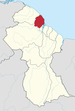
Map of Guyana showing Pomeroon-Supenaam region
CountryFlag of Guyana.svg  Guyana
Regional Capital Anna Regina
Area
  Total6,195 km2 (2,392 sq mi)
Population
 (2012 census)
  Total46,810
  Density7.6/km2 (20/sq mi)
Time zone UTC-4
[1]

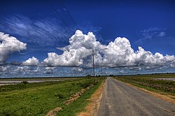
Pomeroon-Supenaam (Region 2) is a region of Guyana. It borders the Atlantic Ocean to the north, the region of Essequibo Islands-West Demerara to the east, the region of Cuyuni-Mazaruni to the south and the region of Barima-Waini to the west. Pomeroon-Supenaam contains the town of Anna Regina and the villages of Charity, Pickersgill, Spring Garden and Suddie. In 2012, an Official Census by the Government of Guyana listed the population of the Pomeroon-Supenaam Region at 46,810. [2]

Contents

There are three lakes on the Essequibo Coast - Capoey, Mainstay and Hot and Cold. Capoey is near Anna Regina. The three lakes symbolize three of the standard elements, with earth being represented by the land.

Population

The Government of Guyana has administered three official censuses since the 1980 administrative reforms, in 1980, 1991 and 2002. [3] In 2002, the population of Pomeroon-Supenaam was recorded at 49,253 people. [2] Official census records for the population of the Pomeroon-Supenaam region are as follows:

Communities

(including name variants): [4]

Notable people

See also


Related Research Articles

<span class="mw-page-title-main">Barima-Waini</span> Region of Guyana

Barima-Waini is a region of Guyana and is located in the northwest of the country. Barima-Waini has three sub-regions: Mabaruma, Matakai, and Moruca.

<span class="mw-page-title-main">Cuyuni-Mazaruni</span> Region of Guyana

Cuyuni-Mazaruni is a region of Guyana. Its capital is Bartica, with villages including Issano, Kartabo, Kamarang, and Imbaimadai.

<span class="mw-page-title-main">East Berbice-Corentyne</span> Region of Guyana

East Berbice-Corentyne is one of ten regions in Guyana covering the whole of the east of the country. It borders the Atlantic Ocean to the north, the Nickerie District and Sipaliwini District of Suriname to the east, Brazil to the south and the regions of Mahaica-Berbice, Upper Demerara-Berbice, Potaro-Siparuni and Upper Takutu-Upper Essequibo to the west.

<span class="mw-page-title-main">Mahaica-Berbice</span> Region of Guyana

Mahaica-Berbice is a region of Guyana, bordering the Atlantic Ocean to the north, the region of East Berbice-Corentyne to the east, the region of Upper Demerara-Berbice to the south and the region of Demerara-Mahaica to the west.

<span class="mw-page-title-main">Demerara-Mahaica</span> Region of Guyana

Demerara-Mahaica is a region of Guyana, bordering the Atlantic Ocean to the north, the region of Mahaica-Berbice to the east, the region of Upper Demerara-Berbice to the south and the region of Essequibo Islands-West Demerara to the west.

<span class="mw-page-title-main">Essequibo Islands-West Demerara</span> Region of Guyana

Essequibo Islands-West Demerara is a region of Guyana. It is situated around the Essequibo River, the largest river in Guyana that lies between the Orinoco and Amazon rivers of South America.

<span class="mw-page-title-main">Upper Demerara-Berbice</span> Region of Guyana

Upper Demerara-Berbice is a region of Guyana, bordering the regions of Essequibo Islands-West Demerara, Demerara-Mahaica and Mahaica-Berbice to the north, the region of East Berbice-Corentyne to the east, and the regions of Potaro-Siparuni and Cuyuni-Mazaruni to the west.

<span class="mw-page-title-main">Potaro-Siparuni</span> Region of Guyana

Potaro-Siparuni is a region of Guyana. It borders the region of Cuyuni-Mazaruni to the north, the regions of Upper Demerara-Berbice and East Berbice-Corentyne to the east, the region of Upper Takutu-Upper Essequibo to the south and Brazil to the west.

<span class="mw-page-title-main">Upper Takutu-Upper Essequibo</span> Region of Guyana

Upper Takutu-Upper Esequibo is a region of Guyana. It borders the region of Potaro-Siparuni to the north, the region of East Berbice-Corentyne to the east and Brazil to the south and west. It contains the town of Lethem, and the villages of Aishalton, Nappi and Surama. It is also the largest region of Guyana.

Anna Regina is the administrative centre and regional capital of the Pomeroon-Supenaam Region of Guyana. Anna Regina stands on the Atlantic coast, northwest of the mouth of the Essequibo River, 19 km north of Adventure, and was established as a town in 1970. Its population was 2,064 in 2012.

Suddie is a community in the Pomeroon-Supenaam region of Guyana, located on the Atlantic Ocean, one mile north of Onderneeming.

<span class="mw-page-title-main">Cheddi Jagan Bio Diversity Park</span>

Cheddi Jagan Bio Diversity Park is a park in Lima Sands Pomeroon-Supenaam, Guyana. It was opened in 2002 in memory of former president Cheddi Jagan.

<span class="mw-page-title-main">Mainstay Lake</span>

Mainstay Lake is a lake in the Pomeroon-Supenaam Region of Guyana, near the Atlantic coast, northwest of the mouth of the Essequibo River, 12 mi (19 km) north of Adventure. There is a 0.5 mi (0.80 km) stretch of white sand at the edge of the lake.

Pickersgill is a village in the Pomeroon-Supenaam of Guyana. It is located near the Pomeroon River.

<span class="mw-page-title-main">Supenaam</span> Village in Pomeroon-Supenaam, Guyana

Supenaam is a port village located in the Pomeroon-Supenaam region of Guyana. Supenaam is home to the ferry across the Essequibo River to Parika. The ferry is the main link between the western half of Guyana and the eastern half.

<span class="mw-page-title-main">Capoey</span> Village in Pomeroon-Supenaam, Guyana

Capoey is a village in the Pomeroon-Supenaam Region of Guyana. The village is mainly inhabited by Lokono Amerindians. It is located on Lake Capoey, a blackwater lake, which is one of largest lakes of Essequibo.

Queenstown is a village in the Pomeroon-Supenaam Region of Guyana. It is located on the Atlantic Ocean coast. It is one of the first villages where the emancipated African slaves bought the lands. Queenstown is home to the oldest extant mosque of Guyana.

<span class="mw-page-title-main">Lima Sands</span> Village in Pomeroon-Supenaam, Guyana

Lima Sands is a village in the Pomeroon-Supenaam Region of Guyana. It is located to the west of Anna Regina. The Cheddi Jagan Bio Diversity Park is in Lima Sands.

References

  1. Macmillan Publishers (2009). "Administrative Regions - 2 and 3". Macmillan Junior Atlas: Guyana. Oxford: Macmillan Caribbean. p. 34. ISBN   9780333934173.
  2. 1 2 Beaie, Sonkarley Tiatun (19 September 2007). "National Population Trends: Size, Growth and Distribution" (PDF Download). 2002 Population and Housing Census - Guyana National Report. Bureau of Statistics. p. 25. Retrieved 29 August 2012.
  3. Beaie, Sonkarley Tiatun (19 September 2007). "Chapter 3: National Redistribution and Internal Migration" (PDF). 2002 Population and Housing Census - Guyana National Report. Bureau of Statistics. p. 51. Archived from the original (PDF) on 17 February 2012. Retrieved 29 August 2012.
  4. "2012 Population by Village". Statistics Guyana. Retrieved 8 December 2021.

7°12′N58°48′W / 7.200°N 58.800°W / 7.200; -58.800