
Barima-Waini is a region of Guyana and is located in the northwest of the country. Barima-Waini has three sub-regions: Mabaruma, Matakai, and Moruca.

Pomeroon-Supenaam is a region of Guyana. It borders the Atlantic Ocean to the north, the region of Essequibo Islands-West Demerara to the east, the region of Cuyuni-Mazaruni to the south and the region of Barima-Waini to the west. Pomeroon-Supenaam contains the town of Anna Regina and the villages of Charity, Pickersgill, Spring Garden and Suddie. In 2012, an Official Census by the Government of Guyana listed the population of the Pomeroon-Supenaam Region at 46,810.

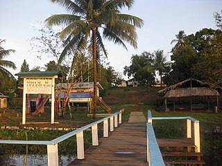
Charity is a small township in Guyana, located in the Pomeroon-Supenaam Region No.2, which is part of the Essequibo County.
Apoteri is a village in the Upper Takutu-Upper Essequibo Region of Guyana, near the confluence of the Rupununi River with the Essequibo, at an altitude of 53 metres. Apoteri started to develop as the centre of the balatá industry. The population is mainly Amerindian of the Macushi and Wapishana people.

Annai is an Amerindian village in the Upper Takutu-Upper Essequibo Region of Guyana.
Kabakaburi is an Amerindian village in the Pomeroon-Supenaam Region of Guyana on the Pomeroon River, 56 km (35 mi) from its mouth. The village was founded in 1845 by William Henry Brett on the location where Fort Durban used to be.
The Arawak village of Wakapau (or Wakapoa) is located in the Pomeroon-Supenaam Region of Guyana, on the Wakapau River, a tributary on the west bank of the Pomeroon River, 3 kilometres (1.9 mi) from its mouth. The name originates from the Lokono word ‘Wakokwãn’, which means pigeon. The village is composed of twenty inhabited islands. Some of the islands only contain a single family.
Suddie is a community in the Pomeroon-Supenaam region of Guyana, located on the Atlantic Ocean, one mile north of Onderneeming.
Bethany Village is a mission located on the Araburia River, a tributary three miles up the Supenaam River in Pomeroon-Supenaam, Essequibo in Guyana.

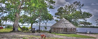
Mainstay Lake is a lake in the Pomeroon-Supenaam Region of Guyana, near the Atlantic coast, northwest of the mouth of the Essequibo River, 12 mi (19 km) north of Adventure. There is a 0.5 mi (0.80 km) stretch of white sand at the edge of the lake.
Surama is an Amerindian village in the North Rupununi area and the Upper Takutu-Upper Essequibo Region of Guyana, with a population of 274 people as of 2012.
George Simon was a Guyanese Lokono Arawak artist and archaeologist. He was the founder and mentor of the Lokono Artists Group, a group of Lokono artists from Guyana, based primarily in his hometown of St. Cuthbert's Mission. Simon was widely regarded as one of the leading Guyanese artists of his generation, and his paintings are notable for their explorations of Amerindian culture and the Guyanese environment. He was also recognized for his achievements as an educator, his efforts to develop opportunities for Amerindian artists in Guyana, and for his work as an archaeologist.
Fairview (Kurupukari) is an indigenous settlement on the Essequibo River, in the Upper Demerara-Berbice region of Guyana. It is the entry point to the Iwokrama Forest. Former president David A. Granger once referred to Iwokrama as the "green heart of Guyana."
Issano is a village of Cuyuni-Mazaruni, Guyana. It's located along the Mazaruni River, and is a hub for mining.
Rewa is an Amerindian village in the Upper Takutu-Upper Essequibo region of Guyana.

Yupukari is an indigenous village of Macushi and Wapishana Amerindians in the Upper Takutu-Upper Essequibo Region of Guyana. It is located between the Kanuku and Pakaraima Mountains along the Rupununi River.
St. Ignatius is an Amerindian village in the Upper Takutu-Upper Essequibo region of Guyana, near the regional capital Lethem and the border of Brazil. It was originally a mission founded by Jesuit priests to serve the Amerindians in the Rupununi savannah.

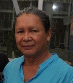
Yvonne Fredericks-Pearson is a Guyanese politician. She has been a member of the National Assembly since 2015. She served as Toshao of Mainstay/Whyaka from 1994 to 2012.

Santa Mission is a village in the Essequibo Islands-West Demerara Region of Guyana. Santa Mission is mainly inhabited by Lokono Amerindians. The village is located on the Kamuni Creek, a tributary of the Demerara River. The village of Hopetown, an early Chinese settlement, is located about 15 kilometres (9.3 mi) from Santa Mission.
Capoey is a village in the Pomeroon-Supenaam Region of Guyana. The village is mainly inhabited by Lokono Amerindians. It is located on Lake Capoey, a blackwater lake, which is one of largest lakes of Essequibo.
