
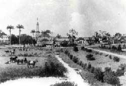
Georgetown is the capital and largest city of Guyana. It is situated in Demerara-Mahaica, region 4, on the Atlantic Ocean coast, at the mouth of the Demerara River. It is nicknamed the "Garden City of the Caribbean." It is the retail, administrative, and financial services centre of the country, and the city accounts for a large portion of Guyana's GDP. The city recorded a population of 118,363 in the 2012 census.

Demerara is a historical region in the Guianas, on the north coast of South America, now part of the country of Guyana. It was a Dutch colony until 1815 and a county of British Guiana from 1838 to 1966. It was located around the lower course of the Demerara River, and its main settlement was Georgetown.

Mabaruma is the administrative centre for Region One (Barima-Waini) of Guyana. It is located close to the Aruka River on a narrow plateau above the surrounding rainforest at an elevation of 13 metres.
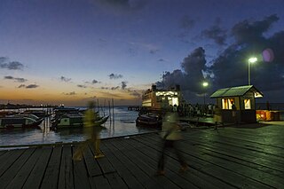
Parika is a port village located in the Essequibo Islands-West Demerara region of Guyana. Its ferry service is operated by the Ministry of Transportation, to and from the Essequibo Islands and West Demerara area. It is a hub for land transport, since it is a route stop for local taxis commonly called "buses."

Charity is a small township in Guyana, located in the Pomeroon-Supenaam Region No.2, which is part of the Essequibo County.

Mahdia is the capital of the Potaro-Siparuni region of Guyana, located near the centre of the country at an altitude of 415 metres (1,362 ft).
Zeelandia, a community in the Essequibo Islands-West Demerara region of Guyana.
Belladrum is a small community in the Mahaica-Berbice Region of Guyana, on the Atlantic coast, about 15 kilometres (9 mi) east of Mahaicony.
Koriabo is a community in the Barima-Waini region of Guyana, standing at an altitude of 36 metres. Barima and Koriba form an Amerindian community which is mainly inhabited by Warao people with a minority of Arawak and Kalina people.
Vreed en Hoop is a village at the mouth of the Demerara River on its left bank, in the Essequibo Islands-West Demerara region of Guyana, located at sea level. It is the location of the Regional Democratic Council office making it the administrative center for the region. There is also a police station, magistrate's court and post office.
Annandale is a community in the Demerara-Mahaica region of Guyana, located on the Atlantic Ocean between Buxton, and Lusignan. Many of the inhabitants originally came from the Lusignan estate, while the former slaves of the plantation, bought the neighbouring Orange Nassau plantation and named it Buxton. Annandale is mainly an Indo-Guyanese community. It is divided in Annandale North, South, West and Courabane Park. The economy used to be dependent on the nearby sugar estates. The secondary school for the region is located in Annandale.
Suddie is a community in the Pomeroon-Supenaam region of Guyana, located on the Atlantic Ocean, one mile north of Onderneeming.

Clonbrook is a village in the Demerara-Mahaica region of Guyana. The village itself has a population of about 1,193 as of 2012. The village is located along the East Coast Highway and is about 16.5 miles from Georgetown and about 6 miles from Mahaica. It is bordered in the east by the village of Bee Hive and by Ann's Grove in the west.
Unity is a rural village in the East Coast district of the Demerara-Mahaica region of Guyana. The village is notable for being the birthplace of both Shivnarine Chanderpaul, former captain of the West Indies cricket team and Bharrat Jagdeo, former president of Guyana. Colin Croft is also from the area.

Guyana, officially the Co‑operative Republic of Guyana, is a country on the northern mainland of South America. Guyana is an indigenous word which means "Land of Many Waters". The capital city is Georgetown. Guyana is bordered by the Atlantic Ocean to the north, Brazil to the south and southwest, Venezuela to the west, and Suriname to the east. With 215,000 km2 (83,000 sq mi), Guyana is the third-smallest sovereign state by area in mainland South America after Uruguay and Suriname, and is the second-least populous sovereign state in South America after Suriname; it is also one of the least densely populated countries on Earth. It has a wide variety of natural habitats and very high biodiversity.
Leonora is a village in Essequibo Islands-West Demerara, one of Guyana's 10 regions. Its subdivisions are Pasture, Sea Field, Para Field, Groenveldt and Sea Spray. The neighboring villages are Anna Catherina and Uitvlugt. Leonora encompasses an area of about 13 square kilometres (5 sq mi), once part of the Parish of St. Luke. It stretches from Edinburgh in the east to Stewartville in the west, and from the Atlantic Ocean in the north, to the south as far as the West Demerara Water Conservancy.
Pomeroon is the name of a former Dutch plantation colony on the Pomeroon River in the Guyana region on the north coast of South America. After early colonization attempts in the late 16th century were attacked by Spaniards and local Indians, the original inhabitants fled the interior of Guyana, founding the colony of Essequibo around Fort Kyk-Over-Al shortly after. A second, and more serious attempt at colonization started in 1650, but was ultimately unsuccessful, as French privateers destroyed the colony in 1689. In the late 18th century, a third attempt of colonization was started, this time under the jurisdiction of the Essequibo colony.
Fort Wellington is a village located in the Mahaica-Berbice region of Guyana, serving as its regional capital.
Kingston is a former village in Demerara. In 1837, it became a ward of Georgetown. The ward is located along the Atlantic Ocean coast. Kingston is home to many landmarks and historic buildings.
Queenstown is a village in the Pomeroon-Supenaam Region of Guyana. It is located on the Atlantic Ocean coast. It is one of the first villages where the emancipated African slaves bought the lands. Queenstown is home to the oldest extant mosque of Guyana.
