
Barima-Waini is a region of Guyana. Venezuela claims the territory as part of Guayana Esequiba.
Potaro-Siparuni is a region of Guyana. Venezuela claims the territory as part of Guayana Esequiba.

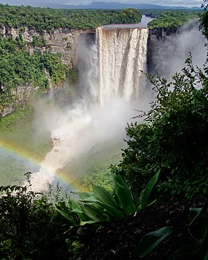
The Potaro River is a river in Guyana that runs from Mount Ayanganna area of the Pakaraima Mountains for approximately 225 km (140 mi) before flowing into the Essequibo River, Guyana's largest river. The renown Kaieteur Falls is on the Potaro.
The Wapichan or Wapishana are an indigenous group found in the Roraima area of southern Guyana and northern Brazil.

Mahdia is the capital of the Potaro-Siparuni region of Guyana, located near the centre of the country at an altitude of 415 metres (1,362 ft).

Campbelltown is an Amerindian village in the Potaro-Siparuni Region of Guyana, north of Mahdia. The village has been named after Stephen Campbell, the first Amerindian member of Parliament in Guyana.
Princeville is an Amerindian community in the Potaro-Siparuni Region of Guyana.
Tumatumari is a community in the Potaro-Siparuni Region of Guyana, located some 15 km upstream of the confluence of the Potaro and Essequibo Rivers.

Tumatumari Landing is a small community in the Potaro-Siparuni Region of Guyana, across the Potaro River from Tumatumari, near the Konawaruk Road, and to the east of El Paso.
El Paso is a village in the Potaro-Siparuni Region of Guyana. The village is on the Potaro River to the west of Tumatumari Falls, and Tumatumari Landing.
Aishalton is an Amerindian village that is situated in the Rupununi savannah of southern Guyana, in the Upper Takutu-Upper Essequibo Region of the country.

Paramakatoi is an Amerindian community in the Potaro-Siparuni Region of Guyana, located in the Pacaraima Mountains. With an altitude of 970 metres, it is 11 miles east of Kurukabaru.

Guyana, officially the Co‑operative Republic of Guyana, is a country on the northern mainland of South America and the capital city is Georgetown. It is part of the mainland Caribbean region maintaining its strong cultural, historical, and political ties with other Caribbean countries and the Caribbean Community (CARICOM). Guyana is bordered by the Atlantic Ocean to the north, Brazil to the south and southwest, Venezuela to the west, and Suriname to the east. With 215,000 square kilometres (83,000 sq mi), Guyana is the third-smallest sovereign state by area in mainland South America after Uruguay and Suriname; it is also the second-least populous sovereign state in South America after Suriname.

El Paso–Juárez, also known as Juárez–El Paso, the Borderplex or Paso del Norte, is a transborder agglomeration, on the border between Mexico and the United States. The region is centered on two large cities: Ciudad Juárez, Chihuahua, Mexico and El Paso, Texas, U.S. Additionally, nearby Las Cruces, New Mexico, U.S. is sometimes included as part of the region, referred to as El Paso–Juárez–Las Cruces or El Paso–Juárez–Southern New Mexico. With over 2.7 million people, this binational region is the 2nd largest conurbation on the United States–Mexico border. The El Paso–Juárez region is the largest bilingual, binational work force in the Western Hemisphere.
Wowetta is an indigenous village in the Upper Takutu-Upper Essequibo Region in Guyana. The village is mainly inhabited by Macushi people.
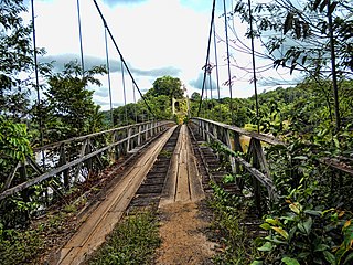
The Denham Suspension Bridge, also known as the Garraway Stream Bridge is a footbridge in Guyana linking Mahdia to Bartica. This suspension bridge was constructed over the Potaro River in an area known as Garraway Stream by a Scottish civil engineer and general contractor, John Aldi, on 6 November 1933.
Parakari is a fermented alcoholic beverage made by Amerindians of Guyana. Like other cassava alcoholic beverages, parakari is made by dual fermenting cassava, which involves the use of an amylolytic mold by chewing it.
Fairview (Kurupukari) is an indigenous settlement on the Essequibo River, in the Upper Demerara-Berbice region of Guyana. It is the entry point to the Iwokrama Forest. Former president David A. Granger once referred to Iwokrama as the "green heart of Guyana."
Isseneru is an Amerindian settlement in the Cuyuni-Mazaruni region of Guyana, approximately 15–20 miles west of Kurupung.
