The transport sector comprises the physical infrastructure, docks and vehicle, terminals, fleets, ancillary equipment and service delivery of all the various modes of transport operating in Guyana. The transport services, transport agencies providing these services, the organizations and people who plan, build, maintain, and operate the system, and the policies that mold its development.

Guyana is divided into 10 Regions:

Demerara is a historical region in the Guianas, on the north coast of South America, now part of the country of Guyana. It was a Dutch colony until 1815 and a county of British Guiana from 1838 to 1966. It was located around the lower course of the Demerara River, and its main settlement was Georgetown.

Linden is the second largest city in Guyana after Georgetown, and capital of the Upper Demerara-Berbice region, located at 6°0′0″N58°18′0″W, altitude 48 m (160 ft). It was declared a town in 1970, and includes the communities of MacKenzie, Christianburg, and Wismar. It lies on the Demerara River and has a population of 27,277 as of 2012. It is primarily a bauxite mining town, containing many mines 60–90 m deep, with many other pits now in disuse. Linden is the regional capital of Upper Demerara-Berbice.

Charity is a small township in Guyana, located in the Pomeroon-Supenaam Region No.2, which is part of the Essequibo County.

Upper Demerara-Berbice is a region of Guyana, bordering the regions of Essequibo Islands-West Demerara, Demerara-Mahaica and Mahaica-Berbice to the north, the region of East Berbice-Corentyne to the east, and the regions of Potaro-Siparuni and Cuyuni-Mazaruni to the west.
Ituni is a village in the interior of Guyana, at an altitude of 100 metres (331 feet). The area grew as a result of bauxite mining in the area.
Afro-Guyanese are generally descended from the enslaved people brought to Guyana from the coast of West Africa to work on sugar plantations during the era of the Atlantic slave trade. Coming from a wide array of backgrounds and enduring conditions that severely constrained their ability to preserve their respective cultural traditions contributed to the adoption of Christianity and the values of British colonists.

The Demerara Harbour Bridge is a 6,074-foot (1,851 m) long floating toll bridge. It was commissioned on 2 July 1978. The bridge crosses the Demerara River 4 miles (6.4 km) south of the Guyanese capital Georgetown, from Peter's Hall, Demerara-Mahaica, East Bank Demerara to Schoon Ord, Essequibo Islands-West Demerara, West Bank Demerara. There is a pedestrian footwalk. A raised section lets small vessels pass under. A retractor span lets large vessels pass.
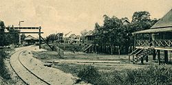
The Railways of Guyana comprised two public railways, the Demerara-Berbice Railway and the Demerara-Essequibo railway. There are also several industrial railways mainly for the bauxite industry. The Demerara-Berbice Railway is the oldest in South America. None of the railways are in operation in the 21st century.
Vreed en Hoop is a village at the mouth of the Demerara River on its left bank, in the Essequibo Islands-West Demerara region of Guyana, located at sea level. It is the location of the Regional Democratic Council office making it the administrative center for the region. There is also a police station, magistrate's court and post office.
The Amacuro River is a river in South America. It forms part of the northern section of the international boundary between Venezuela and Guyana. It is part of the Orinoco River basin.
St. Cuthbert's Mission is an Amerindian village on the Mahaica River in the Demerara-Mahaica region of Guyana. It comprises approximately 200 households. St. Cuthbert's is regarded by many people in Guyana as the "cultural capital" for Amerindians.
Den Amstel is a village in Guyana's Essequibo Islands-West Demerara region. It lies on the Atlantic coast, approximately 13 kilometres (8.1 mi) west-north-west of the capital, Georgetown. The village has a population of 938 people as of 2012, who are predominantly Afro-Guyanese.
Fairview (Kurupukari) is an indigenous settlement on the Essequibo River, in the Upper Demerara-Berbice region of Guyana. It is the entry point to the Iwokrama Forest. Former president David A. Granger once referred to Iwokrama as the "green heart of Guyana."

The COVID-19 pandemic in Guyana is part of the worldwide pandemic of coronavirus disease 2019 caused by severe acute respiratory syndrome coronavirus 2. The virus was confirmed to have reached Guyana on 11 March 2020. The first case was a woman who travelled from New York, a 52-year-old woman with underlying health conditions, including diabetes and hypertension. The woman died at the Georgetown Public Hospital.
Aranaputa is an Amerindian village in the Upper Takutu-Upper Essequibo, Guyana. It is located in the Pacaraima Mountains.
Rewa is an Amerindian village in the Upper Takutu-Upper Essequibo region of Guyana.
St. Ignatius is an Amerindian village in the Upper Takutu-Upper Essequibo region of Guyana, near the regional capital Lethem and the border of Brazil. It was originally a mission founded by Jesuit priests to serve the Amerindians in the Rupununi savannah.

Santa Mission is a village in the Essequibo Islands-West Demerara Region of Guyana. Santa Mission is mainly inhabited by Lokono Amerindians. The village is located on the Kamuni Creek, a tributary of the Demerara River. The village of Hopetown, an early Chinese settlement, is located about 15 kilometres (9.3 mi) from Santa Mission.