
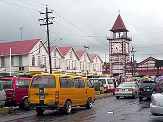
Georgetown is the capital and largest city of Guyana. It is situated in Demerara-Mahaica, region 4, on the Atlantic Ocean coast, at the mouth of the Demerara River. It is nicknamed the "Garden City of the Caribbean." It is the retail, administrative, and financial services centre of the country, and the city accounts for a large portion of Guyana's GDP. The city recorded a population of 118,363 in the 2012 census.

Paramaribo is the capital and largest city of Suriname, located on the banks of the Suriname River in the Paramaribo District. Paramaribo has a population of roughly 241,000 people, almost half of Suriname's population. The historic inner city of Paramaribo has been a UNESCO World Heritage Site since 2002.

Demerara is a historical region in the Guianas, on the north coast of South America, now part of the country of Guyana. It was a Dutch colony until 1815 and a county of British Guiana from 1838 to 1966. It was located around the lower course of the Demerara River, and its main settlement was Georgetown.
Demerara-Mahaica is a region of Guyana, bordering the Atlantic Ocean to the north, the region of Mahaica-Berbice to the east, the region of Upper Demerara-Berbice to the south and the region of Essequibo Islands-West Demerara to the west.

Essequibo Islands-West Demerara is a region of Guyana.

Pomeroon-Supenaam is a region of Guyana. Venezuela claims the territory as part of Guayana Esequiba.
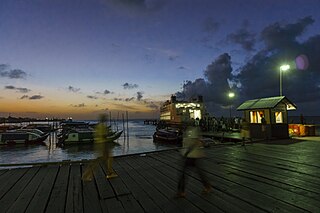
Parika is a port village located in the Essequibo Islands-West Demerara region of Guyana. Its ferry service is operated by the Ministry of Transportation, to and from the Essequibo Islands and West Demerara area. It is a hub for land transport, since it is a route stop for local taxis commonly called "buses."

Upper Demerara-Berbice is a region of Guyana, bordering the regions of Essequibo Islands-West Demerara, Demerara-Mahaica and Mahaica-Berbice to the north, the region of East Berbice-Corentyne to the east, and the regions of Potaro-Siparuni and Cuyuni-Mazaruni to the west.

The Demerara Harbour Bridge is a 6,074-foot (1,851 m) long floating toll bridge. It was commissioned on 2 July 1978. The bridge crosses the Demerara River 4 miles (6.4 km) south of the Guyanese capital Georgetown, from Peter's Hall, Demerara-Mahaica, East Bank Demerara to Schoon Ord, Essequibo Islands-West Demerara, West Bank Demerara. There is a pedestrian footwalk. A raised section lets small vessels pass under. A retractor span lets large vessels pass.
Belfield is a village in the Demerara-Mahaica Region of Guyana, standing on the Atlantic coast, three kilometres west of Enmore.
Vreed en Hoop is a village at the mouth of the Demerara River on its left bank, in the Essequibo Islands-West Demerara region of Guyana, located at sea level. It is the location of the Regional Democratic Council office making it the administrative center for the region. There is also a police station, magistrate's court and post office.

The regions of Guyana are divided into three types of councils: municipal or town councils, neighbourhood democratic councils and Amerindian villages.
Zeeburg is a village located on the West Coast of Demerara in Guyana, South America. The village, in the administrative region Essequibo Islands-West Demerara was named by the Dutch during their occupation of Guyana.

Meerzorg is a town and resort (municipality) in Suriname, located on the eastern bank of the Suriname River, directly opposite the capital Paramaribo. Its population at the 2012 census was 12,405. Since 2000 it has been connected to Paramaribo by the Jules Wijdenbosch Bridge, named after the former President Jules Wijdenbosch.
Uitvlugt is a village in the Essequibo Islands-West Demerara region of Guyana. On the coastal public road on the west bank of the Demerara River, it lies immediately to the west of Stewartville and to the south of Zeeburg, about 20 minutes by road from Vreed-en-Hoop.
Soesdyke is a village in the Demerara-Mahaica Region, Guyana, located between the Demerara River and the East Bank Public Road. Soesdyke is located just after the village called Den Heuvel (Coverden) if you are coming from Georgetown, which is the capital of Guyana. On the other end of Soesdyke is the village Timehri about 3 miles northeast of the Cheddi Jagan International Airport.
Den Amstel is a village in Guyana's Essequibo Islands-West Demerara region. It lies on the Atlantic coast, approximately 13 kilometres (8.1 mi) west-north-west of the capital, Georgetown. The village has a population of 938 people as of 2012, who are predominantly Afro-Guyanese.

Squatting in Guyana is the occupation of unused land or derelict buildings without the permission of the owner. Squatting has been used as a means to find housing by people displaced by conflict in the 1960s and by internal migrants from the 1980s onwards. In 2015, there were estimated to be over 100,000 squatters across the country. The government announced the National Squatter Regularisation Commission (NSRC) and the State Land Resettlement Commission in 2020, in the following year it allied with UN-Habitat to create the Guyana Strategy for Informal Settlements Upgrading and Prevention (GSISUP) which aims to regularize all informal settlements by 2030.
Tuschen is a village in the Essequibo Islands-West Demerara Region of Guyana. It is located along the Atlantic Ocean coast. The original name of the village was Tuschen de Vrienden. During the 20th century, it was a small village. The Tuschen Housing Scheme resulted in a considerable growth, and is one of the largest housing schemes in Guyana.
