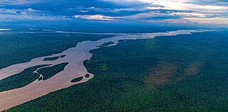
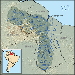
The Essequibo River is the largest river in Guyana, and the largest river between the Orinoco and Amazon. Rising in the Acarai Mountains near the Brazil–Guyana border, the Essequibo flows to the north for 1,014 kilometres (630 mi) through forest and savanna into the Atlantic Ocean. With a total drainage basin of 156,828 square kilometres (60,552 sq mi) and an average discharge of 4,531–5,650 cubic metres per second (160,000–199,500 cu ft/s).
The Rupununi is a region in the south-west of Guyana, bordering the Brazilian Amazon. The Rupununi river, also known by the local indigenous peoples as Raponani, flows through the Rupununi region. The name Rupununi originates from the word rapon in the Makushi language, in which it means the black-bellied whistling duck found along the river.

The Kanuku Mountains are a group of mountains in Guyana, located in the Upper Takutu-Upper Essequibo region. The name means 'forest' in the Wapishana language, a reference to the rich diversity of wildlife found there. The Eastern Kanuku Mountains and the Western Kanuku Mountains are separated by the Rupununi River. In 2011, the mountains were designated National Protected Area.

The Rupununi savannah is a savanna plain in Guyana, in the Upper Takutu-Upper Essequibo region. It is part of the Guianan savanna ecoregion of the tropical and subtropical grasslands, savannas, and shrublands biome.

The Macushi are an indigenous people living in the borderlands of southern Guyana, northern Brazil in the state of Roraima, and in an eastern part of Venezuela.
Achiwib is a village in the Upper Takutu-Upper Essequibo Region of Guyana. Achiwib is an Amerindian community that borders Brazil, the main language spoken in the village is Wapishana language.
Apoteri is a village in the Upper Takutu-Upper Essequibo Region of Guyana, near the confluence of the Rupununi River with the Essequibo, at an altitude of 53 metres. Apoteri started to develop as the centre of the balatá industry. The population is mainly Amerindian of the Macushi and Wapishana people.

Annai is an Amerindian village in the Upper Takutu-Upper Essequibo Region of Guyana.
Wowetta is an indigenous village in the Upper Takutu-Upper Essequibo Region in Guyana. The village is mainly inhabited by Macushi people.
Surama is an Amerindian village in the North Rupununi area and the Upper Takutu-Upper Essequibo Region of Guyana, with a population of 274 people as of 2012.
Fairview (Kurupukari) is an indigenous settlement on the Essequibo River, in the Upper Demerara-Berbice region of Guyana. It is the entry point to the Iwokrama Forest. Former president David A. Granger once referred to Iwokrama as the "green heart of Guyana."

Sydney Charles Allicock was minister of Indigenous People's Affairs in Guyana from 2015-2020, and was vice-president of Guyana from 2015-2020.
Aranaputa is an Amerindian village in the Upper Takutu-Upper Essequibo, Guyana. It is located in the Pacaraima Mountains.
Hiawa is an indigenous village of Macushi Amerindians in the Upper Takutu-Upper Essequibo Region of Guyana. It is located in the Rupununi savannah. Hiawa is considered a satellite of Nappi.
Karasabai is an indigenous village of Macushi Amerindians in the Upper Takutu-Upper Essequibo Region of Guyana. It is located in the South Pakaraima Mountains, and near the Ireng River which flows south to the Amazon River.

Yupukari is an indigenous village of Macushi and Wapishana Amerindians in the Upper Takutu-Upper Essequibo Region of Guyana. It is located between the Kanuku and Pakaraima Mountains along the Rupununi River.
St. Ignatius is an Amerindian village in the Upper Takutu-Upper Essequibo region of Guyana, near the regional capital Lethem and the border of Brazil. It was originally a mission founded by Jesuit priests to serve the Amerindians in the Rupununi savannah.
Karaudarnau is an indigenous village of Wapishana Amerindians in the Upper Takutu-Upper Essequibo Region of Guyana. It is located in the Rupununi savannah on the Rupununi River.
Katoonarib is a village in the Upper Takutu-Upper Essequibo Region of Guyana. Katoonarib is inhabited by Wapishana, Macushi and other Amerindians. It is located near the Rupununi River. The main language spoken in the village is Wapishana with English as secondary language.
Toka is an indigenous village of Macushi Amerindians in the Upper Takutu-Upper Essequibo Region of Guyana. It is located in the North Rupununi Wetlands.
