Stabroek | |
|---|---|
 Stabroek | |
| Coordinates: 6°48′25″N58°09′36″W / 6.8070406°N 58.1599689°W | |
| Country | Guyana |
| City | Georgetown |
| Established | 1782 |
| Area | |
• Total | 0.65 km2 (0.25 sq mi) |
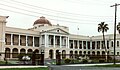
Stabroek is a ward in the centre of Georgetown, Guyana, having previously been the old name of the wider city itself, between 1784 and 1812.