
Barima-Waini is a region of Guyana. Venezuela claims the territory as part of Guayana Esequiba.
Matthews Ridge is a small village within the Barima-Waini administrative region of Guyana. The village name comes from the name of a public official, Matthew Young, as well as the ridges in the area. The village is divided into three sections, Heaven's Hill, Hell Hill and the valley.

Mabaruma is the administrative centre and regional capital for Region One (Barima-Waini) of Guyana. It is located close to the Aruka River on a narrow plateau above the surrounding rainforest at an elevation of 13 metres.
Kamwatta Hill is a community in the Barima-Waini Region, in northern Guyana. Kamwatta is an Amerindian village inhabited by Warao and Arawak people.
Santa Rosa is a community in the Barima-Waini region of northern Guyana. Santa Rosa mission was established in 1840, and is one of the earliest Catholic Missions in Guyana. The village is part of the North West Amerindian District.
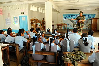
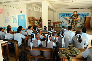
Santa Rosa Secondary School is a secondary school in Santa Rosa, in the Barima-Waini region of northern Guyana. The school was established in 1991, making it the second secondary school in the area after the establishment of North West Secondary School in 1965. Prospective students undergo competitive examination and may take their Caribbean Examinations Council (CXC) examinations upon graduation. As of 2009, the school taught over 650 students, up from 264 in 2005. Of these 264, 72 of whom were housed in a dormitory sponsored by the Inter-American Development Bank. A third wing was built in 2009, adding nine new classrooms to the school. Jonny La'go Payne assumed the role of headmaster in 2005.
Baramita, is a community in the Barima-Waini region of northern Guyana, standing about 20 miles west of Matthew's Ridge, at an altitude of 99 metres.

The Warao are an indigenous Amerindian people inhabiting northeastern Venezuela, Trinidad and Tobago, Guyana, and Suriname. Alternate common spellings of Warao are Waroa, Guarauno, Guarao, and Warrau. The term Warao translates as "the boat people," after the Warao's lifelong and intimate connection to the water. Most Warao inhabit Venezuela's Orinoco Delta region, with smaller numbers in neighbouring Guyana, Trinidad and Tobago, and Suriname. With a population of 49,271 people in Venezuela during the 2011 census, they were the second largest indigenous group after the Wayuu people. They speak an agglutinative language, Warao.
The Arawak village of Wakapau (or Wakapoa) is located in the Pomeroon-Supenaam Region of Guyana, on the Wakapau River, a tributary on the west bank of the Pomeroon River, 3 kilometres (1.9 mi) from its mouth. The name originates from the Lokono word ‘Wakokwãn’, which means pigeon. The village is composed of twenty inhabited islands. Some of the islands only contain a single family.
Koriabo is a community in the Barima-Waini region of Guyana, standing at an altitude of 36 metres. Barima and Koriba form an Amerindian community which is mainly inhabited by Warao people with a minority of Arawak and Kalina people.
Jean La Rose is an Arawak environmentalist and indigenous rights activist in Guyana. She was awarded the Goldman Environmental Prize in 2002 for her work to halt mining in their territories, to secure inhabitants full rights to traditional lands, and to save Guyana's forests.
St. Monica Karawab is a village in the Pomeroon-Supenaam region of Guyana. The village is an Amerindian village.

Carolyn Allison Rodrigues-Birkett is a Guyanese politician who was appointed Permanent Representative of Guyana to the United Nations in 2020. She previously served as Director of the Food and Agriculture Organization Liaison Office in Geneva from 2017 to 2020 and Minister of Foreign Affairs of Guyana from 2008 to 2015.
Stephen Campbell was an Arawakan Guyanese politician and political activist, and the first Amerindian member of Parliament in Guyanese history.
The lands inhabited by indigenous peoples receive different treatments around the world. Many countries have specific legislation, definitions, nomenclature, objectives, etc., for such lands. To protect indigenous land rights, special rules are sometimes created to protect the areas they live in. In other cases, governments establish "reserves" with the intention of segregation. Some indigenous peoples live in places where their right to land is not recognised, or not effectively protected.
Aranaputa is an Amerindian village in the Upper Takutu-Upper Essequibo, Guyana. It is located in the Pacaraima Mountains.
Isseneru is an Amerindian settlement in the Cuyuni-Mazaruni region of Guyana, approximately 15–20 miles west of Kurupung.
Karasabai is an indigenous village of Macushi Amerindians in the Upper Takutu-Upper Essequibo Region of Guyana. It is located in the South Pakaraima Mountains, and near the Ireng River which flows south to the Amazon River.
Whitewater is a village in the Barima-Waini Region of Guyana. Whitewater is located close to the border with Venezuela and is inhabited by Warao Amerindians.

Santa Mission is a village in the Essequibo Islands-West Demerara Region of Guyana. Santa Mission is mainly inhabited by Lokono Amerindians. The village is located on the Kamuni Creek, a tributary of the Demerara River. The village of Hopetown, an early Chinese settlement, is located about 15 kilometres (9.3 mi) from Santa Mission.
