The transport sector comprises the physical infrastructure, docks and vehicle, terminals, fleets, ancillary equipment and service delivery of all the various modes of transport operating in Guyana. The transport services, transport agencies providing these services, the organizations and people who plan, build, maintain, and operate the system, and the policies that mold its development.

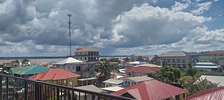
Georgetown is the capital and largest city of Guyana. It is situated in Demerara-Mahaica, region 4, on the Atlantic Ocean coast, at the mouth of the Demerara River. It is nicknamed the "Garden City of the Caribbean." It is the retail, administrative, and financial services centre of the country, and the city accounts for a large portion of Guyana's GDP. The city recorded a population of 118,363 in the 2012 census.
Bartica is a town located on the left bank of the Essequibo River in Cuyuni-Mazaruni, at the confluence of the Cuyuni and Mazaruni Rivers with the Essequibo River in Guyana. It is the regional capital of Cuyuni-Mazaruni.
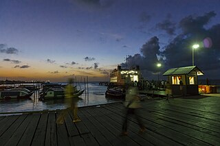
Parika is a port village located in the Essequibo Islands-West Demerara region of Guyana. Its ferry service is operated by the Ministry of Transportation, to and from the Essequibo Islands and West Demerara area. It is a hub for land transport, since it is a route stop for local taxis commonly called "buses."

The Potaro River is a river in Guyana that runs from Mount Ayanganna area of the Pakaraima Mountains for approximately 255 km (158 mi) before flowing into the Essequibo River, Guyana's largest river. The renowned Kaieteur Falls is on the Potaro.
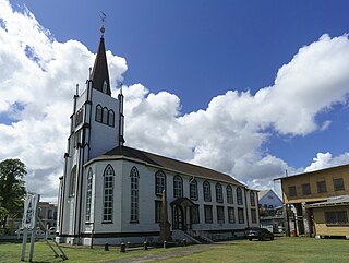
St. Andrew's Kirk is one of the oldest buildings in Georgetown, Guyana that has been continually in use for religious purposes. The Dutch Reformed congregation laid its foundations in 1811. However, due to financial difficulties it was acquired by Scottish Presbyterians and was formally opened for service on 28 February 1818.

Mahdia is a town in Guyana, located near the centre of the country at an altitude of 415 m (1,362 ft).
Campbelltown is an Amerindian village in the Potaro-Siparuni Region of Guyana, north of Mahdia. The village has been named after Stephen Campbell, the first Amerindian member of Parliament in Guyana.
Princeville is an Amerindian community in the Potaro-Siparuni Region of Guyana.
Tumatumari is a community in the Potaro-Siparuni Region of Guyana, located some 15 km upstream of the confluence of the Potaro and Essequibo Rivers.

Tumatumari Landing is a small community in the Potaro-Siparuni Region of Guyana, across the Potaro River from Tumatumari, near the Konawaruk Road, and to the east of El Paso.
Micobie is a village in Potaro-Siparuni, Guyana, on the right bank of the Potaro River near Tumatumari.

The regions of Guyana are divided into three types of councils: municipal or town councils, neighbourhood democratic councils and Amerindian villages.
Kaysia Christina Schultz is a Guyanese cricketer who currently plays for Guyana and Guyana Amazon Warriors as a slow left-arm orthodox bowler. Schultz was born in Bartica, Guyana, and began playing cricket when she was ten.
Issano is a village of Cuyuni-Mazaruni, Guyana. It's located along the Mazaruni River, and is a hub for mining.

Fort Island is an island in the Essequibo River located in the Essequibo Islands-West Demerara region of Guyana. It is about 16 kilometres (10 mi) from the mouth of the river, and to the east of Hogg Island. In 1687, a wooden fort was built on the island. In 1744, Fort Zeelandia was constructed and served as the capital of Essequibo, a Dutch colony which is nowadays part of Guyana. In 1752, the Court of Policy was built on the island as the legislative body for the colony.

Kato is an indigenous village in the Potaro-Siparuni Region of Guyana. The village is mainly inhabited by Patamona people. The village is located in the Pacaraima Mountains.
On May 21, 2023, a fire broke out in a secondary school dormitory in Mahdia, Potaro-Siparuni, Guyana, killing at least 20 people. The fire was among the deadliest involving school dormitories in the last 30 years.

