
A mangrove is a shrub or small tree that grows in coastal saline or brackish water. The term is also used for tropical coastal vegetation consisting of such species. Mangroves occur worldwide in the tropics and subtropics, mainly between latitudes 25° N and 25° S. The total mangrove forest area of the world in 2000 was 137,800 square kilometres (53,200 sq mi), spanning 118 countries and territories.
The flora of Belize is highly diverse by regional standards, given the country's small geographical extent. Situated on the Caribbean coast of northern Central America the flora and vegetation have been intimately intertwined with Belize's history. The nation itself grew out of British timber extraction activities from the 17th century onwards, at first for logwood and later for mahogany, fondly called "red gold" because of its high cost and was much sought after by European aristocracy. Central America generally is thought to have gained much of it characteristic flora during the "Great American interchange" during which time South American elements migrated north after the geological closure of the isthmus of Panama. Few Amazonian elements penetrate as far north as Belize and in species composition the forests of Belize are most similar to the forests of the Petén (Guatemala) and the Yucatán (Mexico).
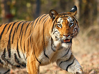
India is home to a large variety of wildlife. It is a biodiversity hotspot with its various ecosystems ranging from the Himalayas in the north to the evergreen rainforests in the south, the desert sands of the west to the marshy mangroves of the east. India, lying within the Indomalayan realm, is home to about 7.6% of mammal, 14.7% of amphibian, 6% of bird, 6.2% of reptilian, and 6.0% of flowering plant species. India's forest lands nurture about 500 species of mammals and 2000+ bird species. This richness of Indian wildlife has been celebrated since time immemorial. Four of India’s national symbols consist India’s mammals.

Since declaring independence in 1981, Belize has enacted many environmental protection laws aimed at the preservation of the country's natural and cultural heritage, as well as its wealth of natural resources. These acts have established a number of different types of protected areas, with each category having its own set of regulations dictating public access, resource extraction, land use and ownership.

Tourism in Belize has grown considerably recently, and it is now the second largest industry in the nation. Belizean Prime Minister Dean Barrow has stated his intention to use tourism to combat poverty throughout the country. The growth in tourism has positively affected the agricultural, commercial, and finance industries, as well as the construction industry. The results for Belize's tourism-driven economy have been significant, with the nation welcoming almost one million tourists in a calendar year for the first time in its history in 2012.

Earthwatch Institute is an international environmental charity founded as Educational Expeditions International in 1971 near Boston (USA) by Robert A. Citron and Clarence Truesdale, then superintendent of Vermont public schools. It is one of the largest global underwriters of scientific field research in archaeology, paleontology, marine life, biodiversity, ecosystems and wildlife. For over forty years, Earthwatch has delivered a unique citizen science model to raise funds and recruit individuals, students, teachers and corporate fellows to participate in critical field research to understand nature's response to accelerating global change. Earthwatch's work supports hundreds of Ph.D. researchers across dozens of countries, conducting over 100,000 hours of research annually.

The natural environment, commonly referred to simply as the environment, includes all living and non-living things occurring naturally on Earth.

The environment of Malaysia is the biotas and geologies that constitute the natural environment of Malaysia. Malaysia's ecology is megadiverse, with a biodiverse range of flora and fauna found in various ecoregions throughout the country. Tropical rainforests encompass between 59% to 70% of Malaysia's total land area, of which 11.6% is pristine. Malaysia has the world's fifth largest mangrove area, which totals over a half a million hectares.

Bacalar Chico National Park and Marine Reserve (BCNPMR) is a protected area and UNESCO World Heritage Site on the northern part of Ambergris Caye in Belize.

Conservation in India can be traced to the time of Ashoka, tracing to the Ashoka Pillar Edicts as one of the earliest conservation efforts in the world. Conservation generally refers to the act of carefully and efficiently using natural resources. Conservation efforts begun in India before 5 AD, as efforts are made to have a forest administration. The Ministry of Environment, Forest and Climate Change is the ministry responsible for implementation of environmental and forestry program in India, which include the management of national parks, conservation of flora and fauna of India, and pollution controls.
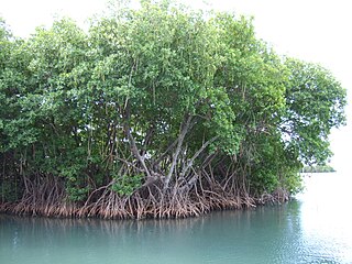
Mangrove ecosystems represent natural capital capable of producing a wide range of goods and services for coastal environments and communities and society as a whole. Some of these outputs, such as timber, are freely exchanged in formal markets. Value is determined in these markets through exchange and quantified in terms of price. Mangroves are important for aquatic life and home for many species of fish.
Ecology Project International is a non-profit organization based in Missoula, Montana, dedicated to developing place-based, ecological education partnerships between local experts and youth to address conservation issues. Ecology Project International (EPI) works with students and educators at seven program sites around the world: Belize, Costa Rica, mainland Ecuador, Galápagos Islands, Hawaii, Mexico, and Yellowstone.

The Menai Bay Conservation Area (MBCA) is located in Menai Bay, Zanzibar Tanzania. At 470 square kilometres (180 sq mi), it is Zanzibar's largest marine protected area. It was officially established as a conservation area in August 1997 in the traditional fishing area, known as Unguja Island, covering the tropical marine environment comprising extensive coral reefs, tropical fish, sea grasses, and mangrove forests. In addition to controlling illegal fishing, MBCA's alternative initiatives have included bee keeping, mangrove replanting, tree nurseries and tourism. The management of the MBCA falls upon the Fisheries Department and the bay's local villages. It is rated by the IUCN as Category VI Managed Resource Protected Area.
Blue Ventures is a science-led social enterprise that develops transformative approaches for nurturing and sustaining locally led marine conservation. The organisation works in partnership with coastal communities in places where the ocean is vital to the culture and economy.

Half Moon Caye is an island and natural monument of Belize located at the southeast corner of Lighthouse Reef Atoll. This natural monument was the first nature reserve to have been established in Belize under the National Park Systems Act in 1981 and first marine protected area in Central America. This is also Belize's oldest site of wildlife protection since it was first designated as a bird sanctuary in 1924 to protect the habitat of the red-footed booby birds.
Nohoch Cheʼen, also commonly known as Caves Branch, is an archaeological reserve in Belize, consisting of a network of limestone caves.
The Sapodilla Cayes are an uninhabited atoll in the Gulf of Honduras. They are in the Toledo District of Belize.

South Water Caye Marine Reserve is the largest marine reserve in the Stann Creek district of Belize. It was established in 1996 and covers 47,702 hectares of mangrove and coastal ecosystems.

Gladden Spit and Silk Cayes Marine Reserve (GSSCMR) is a protected marine reserve in the central part of Belize's Barrier Reef. It covers approximately 25,980 acres (10,510 ha) lying 36 kilometres (22 mi) off the coast of Placencia. Established in 2003, The reserve comes under the authority of the government's Fisheries Department, but is managed by the Southern Environmental Association, a community-based organisation.
