Port Meadow, Oxford

Last updated

Port Meadow
Port Meadow sunset.jpg
Sunset over Port Meadow
Location map United Kingdom Oxford.svg
Red pog.svg
Port Meadow
Oxfordshire UK location map.svg
Red pog.svg
Port Meadow
Location within Oxfordshire
OS grid reference SP495085
Civil parish
  • unparished
District
Shire county
Region
Country England
Sovereign state United Kingdom
Post town Oxford
Postcode district OX2
Dialling code 01865
Police Thames Valley
Fire Oxfordshire
Ambulance South Central
UK Parliament
Website Oxford City Council
List of places
UK
England
Oxfordshire
51°46′12″N1°17′02″W / 51.770°N 1.284°W / 51.770; -1.284

Port Meadow is a large meadow of open common land beside the River Thames to the north and west of Oxford, England. [1]

Contents

Overview

The meadow is an ancient area of grazing land, still used for horses and cattle, and according to legend has never been ploughed, at least for around 4,000 years. It is said that in return for helping to defend the kingdom against the marauding Danes, the Freemen of Oxford were given the 300 acres (120 ha) of pasture next to the River Thames by Alfred the Great who, legend has it, founded the city in the 10th century (although Alfred actually died in the 9th century). The Freemen's collective right to graze their animals free of charge is recorded in the Domesday Book of 1086 and has been exercised ever since. The name may come from Portman, an earlier term for Freeman.

Swimmers at Port Meadow, bathing at the confluence of the River Thames and the Castle Mill Stream. Swimmers in the River Thames at Port Meadow, Oxford, UK.jpg
Swimmers at Port Meadow, bathing at the confluence of the River Thames and the Castle Mill Stream.

The meadow runs from Jericho to Wolvercote (where north of the Shiplake Ditch it becomes Wolvercote Common) along the east (left) bank of the River Thames, with the Cotswold Line railway, the Oxford Canal and the suburb of North Oxford further to the east, and the village of Binsey to the west. Access to Port Meadow is via Walton Well Road or Aristotle Lane in the south (or from the south via Roger Dudman Way or the Thames Path) or from Godstow Road, Wolvercote via Wolvercote Common in the north. It is a typical English flood-meadow and is a favourite area for walking, with easy access from the city of Oxford. It is also a Site of Special Scientific Interest. At the southern end of the meadow is Fiddler's Island in the River Thames. In the winter the meadow sometimes floods; if frozen it forms a huge and relatively safe area for skating. In late spring vast areas are carpeted with buttercups. Horses, cattle and geese graze the meadow and many birds can often be seen.

At the eastern edge of Port Meadow, just north of the entrance from Aristotle Lane, is Burgess Field, a reclaimed landfill site and home to a nature reserve, managed by Oxford City Council. It covers an area of about 35 hectares (86 acres); a circular path around the edge passes through some small copses. [2]

Port Meadow is one of the most popular locations in Oxford for recreation activities such as walking, running, cycling and swimming in the adjacent River Thames. During days of fair weather the banks of the River Thames in the Meadow are often lined with people enjoying the natural environs. The meadow is also popular with photographers and bird-watchers.

History

Horses in the mist on Port Meadow Port Meadow horses in mist.jpg
Horses in the mist on Port Meadow

The River Thames (known as the Isis in this area) flows past this large grazing meadow. This is where the Reverend Charles Lutwidge Dodgson (Lewis Carroll) and the Reverend Robinson Duckworth rowed up the river on 4 July 1862 with three young girls — Lorina, Alice, and Edith Liddell. While journeying slowly from Folly Bridge to near Godstow, Dodgson began at their request to make up a story that later was expanded into Alice's Adventures in Wonderland .

Because the meadow appears never to have been ploughed, it contains well-preserved archaeological remains, some of which survive as residual earthworks. Of particular note are several Bronze Age round barrows, an area of Iron Age settlement, and the foundations of 17th-century fortifications from the Parliamentary siege of Oxford during the English Civil War.

In the 17th and 18th centuries, the meadow was used for horse racing, and low stone bridges laid over washes and ditches for this purpose still survive. [3]

During the First World War part of Port Meadow was used to train the Royal Flying Corps and turned into a military aerodrome. Fifteen air crew and pilots were killed flying from Port Meadow or close by. [4] In 1940, during the Second World War, a camp was set up on the meadow for military personnel evacuated from Dunkirk.

In the 1980s and 1990s, the meadow was known as a location for free festivals and raves. [5] [6] [7]

Just across the Thames is Bossoms Boatyard, with a small marina and Medley Footbridge across the Thames. The Medley Sailing Club, the furthest upstream sailing club on the River Thames, is on the western bank. To the south is the start of the Castle Mill Stream and Cripley Meadow, largely consisting of allotments.

Development

Panoramic view looking south from Port Meadow of new Oxford University Castle Mill graduate housing Panorama of graduate housing from Port Meadow, Oxford.jpg
Panoramic view looking south from Port Meadow of new Oxford University Castle Mill graduate housing
St Barnabas Church campanile obscured by new Oxford University Castle Mill graduate accommodation buildings, at the southern end of Port Meadow Obscured view of St Barnabas campanile from Port Meadow, Oxford.JPG
St Barnabas Church campanile obscured by new Oxford University Castle Mill graduate accommodation buildings, at the southern end of Port Meadow

From 2012, the Oxford University Estates Directorate, with the help of Longcross, have been developing the 2½ acre (one-hectare) Castle Mill site between the Cripley Meadow Allotments and the railway tracks, close to the southern end of Port Meadow, as extensive student accommodation. [8] [9] The development was controversial, since the four to five storey blocks overlook Port Meadow. [10] Campaigners warned of damage to views of Oxford. [11] [12] There has been an online petition [13] and a "Save Port Meadow" campaign was established in December 2012. [14] Concerns were raised by the Oxford Preservation Trust and the Green Party. [15] The Oxford Times reported that "senior university members" were angry about the development, and that the impact had taken time to be realised. [16] The development was likened to building a "skyscraper beside Stonehenge". [17] In February 2013, Oxford City Council entered negotiations with Oxford University to reduce the height of the buildings by two storeys. [18] On 7 May 2013, the Campaign to Protect Rural England applied to the High Court for judicial review of the decision to grant planning permission on the grounds that requirements for a full Environmental Impact Assessment (EIA) were not met.

In 2016, Oxford University proposed an array of mitigating techniques, including cladding and horizontal beams to "break up the vertical façade". [19] Later, changes were made to the buildings in an attempt to reduce their visual impact.

See also

Related Research Articles

<span class="mw-page-title-main">Wolvercote</span> Human settlement in England

Wolvercote is a village that is part of the City of Oxford, England. It is about 3 miles (5 km) northwest of the city centre, on the northern edge of Wolvercote Common, which is itself north of Port Meadow and adjoins the River Thames.

<span class="mw-page-title-main">Binsey, Oxfordshire</span> Village in Oxfordshire, England

Binsey is a small village on the west side of Oxford, in Oxfordshire, England. It lies on the banks of the River Thames about 1.5 miles (2.4 km) northwest of the centre of Oxford, on the opposite side of the river from Port Meadow and about 1 mile (1.6 km) southwest of the ruins of Godstow Abbey.

<span class="mw-page-title-main">Godstow</span> Hamlet in Oxfordshire, UK

Godstow is a hamlet about 2.5 miles (4 km) northwest of the centre of Oxford. It lies on the banks of the River Thames between the villages of Wolvercote to the east and Wytham to the west. The ruins of Godstow Abbey, also known as Godstow Nunnery, are here. A bridge spans the Thames and the Trout Inn is at the foot of the bridge across the river from the abbey ruins. There is also a weir and Godstow lock.

<span class="mw-page-title-main">The Trout Inn</span>

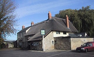
The Trout Inn is a historic pub in Lower Wolvercote north of Oxford, close to Godstow Bridge, directly by the River Thames.

<span class="mw-page-title-main">Osney Lock</span> Lock on the River Thames in Oxfordshire, England

Osney Lock is a lock on the River Thames in Oxford, England, where the village or island of Osney is next to the river.

<span class="mw-page-title-main">Godstow Lock</span> Lock on the River Thames in Oxfordshire, England

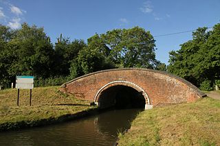
Godstow Lock is a lock on the River Thames in Oxfordshire, England. It is between the villages of Wolvercote and Wytham on the outskirts of Oxford. The first lock was built of stone by Daniel Harris for the Thames Navigation Commission in 1790. It is the lock furthest upstream on the river which has mechanical (electro-hydraulic) operation - every lock upstream of Godstow utilises manual beam operation instead.

<span class="mw-page-title-main">Fiddler's Island</span>

Fiddler's Island is an island in the River Thames at Oxford in England. It is situated south of Port Meadow on the reach above Osney Lock.

<span class="mw-page-title-main">Castle Mill Stream</span> Stream in Oxfordshire, England

Castle Mill Stream is a backwater of the River Thames in the west of Oxford, England. It is 5.5 km long.

<span class="mw-page-title-main">The Perch, Binsey</span> Building in Oxfordshire, England

The Perch is a historic public house in the village of Binsey, Oxfordshire, England, northwest of Oxford and close to the River Thames, overlooking Port Meadow.

<span class="mw-page-title-main">Duke's Cut</span>

Duke's Cut is a short waterway in Oxfordshire, England, which connects the Oxford Canal with the River Thames via the Wolvercote Mill Stream. It is named after George Spencer, 4th Duke of Marlborough, across whose land the waterway was cut. It is seen as a branch of the Oxford Canal.

<span class="mw-page-title-main">Aristotle Lane</span> Street in North Oxford, UK

Aristotle Lane is a road in north Oxford, England.

<span class="mw-page-title-main">Castle Mill</span>

Castle Mill is a graduate housing complex of the University of Oxford in Oxford, England.

<span class="mw-page-title-main">Cripley Meadow</span> Human settlement in England

Cripley Meadow lies between the Castle Mill Stream, a backwater of the River Thames, and the Cotswold Line railway to the east, and Fiddler's Island, on the main branch of the Thames to the west, in Oxford, England. It is to the south of the better known Port Meadow, a large meadow of common land. To the south is Sheepwash Channel which connects the Oxford Canal with the River Thames.

<span class="mw-page-title-main">Longcross (company)</span> Former British construction company

Longcross was a British construction company which entered into administration in June 2015. The head office was based in Ashtead, Surrey, England.

<span class="mw-page-title-main">Wolvercote Common</span> Human settlement in England

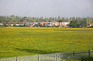
Wolvercote Common is an area of grassed common land north of Port Meadow in Oxford, England.

<span class="mw-page-title-main">Binsey Poplars</span> Poem by Gerard Manley Hopkins, written 1879

"Binsey Poplars" is a poem by Gerard Manley Hopkins (1844–1889), written in 1879. The poem was inspired by the felling of a row of poplar trees near the village of Binsey, northwest of Oxford, England, and overlooking Port Meadow on the bank of the River Thames. The replacements for these trees, running from Binsey north to Godstow, lasted until 2004, when replanting began again.

<span class="mw-page-title-main">Burgess Field Nature Park</span> Human settlement in England

Burgess Field Nature Park is a nature reserve next to Port Meadow, Oxford, in Oxfordshire, England, managed by Oxford City Council.

<span class="mw-page-title-main">Trap Grounds</span> Human settlement in England

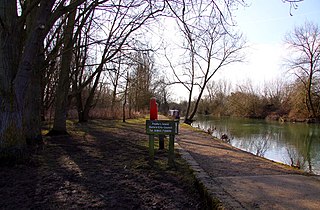
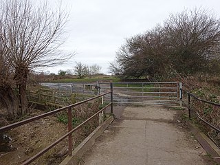
The Trap Grounds is a nature reserve in north Oxford, Oxfordshire, England, owned by Oxford City Council.

<span class="mw-page-title-main">Port Meadow with Wolvercote Common and Green</span>

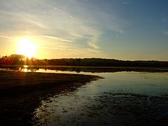
Port Meadow with Wolvercote Common and Green is a 167.1-hectare (413-acre) biological Site of Special Scientific Interest in Oxford in Oxfordshire. It is a Nature Conservation Review site, Grade I, and part of Oxford Meadows Special Area of Conservation. The remains of Godstow Abbey, which is a Scheduled Monument, are in the north of the site.

<span class="mw-page-title-main">Wolvercote Meadows</span>

Wolvercote Meadows is a 7.1-hectare (18-acre) biological Site of Special Scientific Interest north of Oxford in Oxfordshire. Part of it is owned by the Oxford Preservation Trust. It is part of Oxford Meadows Special Area of Conservation.

References

  1. Hibbert, Christopher, ed. (1988). "Port Meadow". The Encyclopaedia of Oxford. Macmillan. pp. 331–332. ISBN   0-333-39917-X.
  2. "Countryside and nature reserves – Burgess Field Nature Park". UK: Oxford City Council . Retrieved 6 January 2020.
  3. Historic Port Meadow to get revamp [ permanent dead link ], The Oxford Times , 8 July 1998.
  4. "Port Meadow Aerodrome, Oxfordshire: Challenges of Training with the Royal Flying Corps, World War One At Home". BBC. Retrieved 10 November 2015.
  5. Oxford Free Festival 1986, UK Rock Festivals , July 2012.
  6. UK Police Halt Rave Party Archived 31 January 2013 at archive.today , Party Vibe , 11 August 1998.
  7. May Morning Tips, Road & Travel Magazine .
  8. "Longcross at the University of Oxford, Castle Mill Phase 2 ∙ Innovation in action". www.longcross.co.uk. Longcross. Archived from the original on 24 February 2014. Retrieved 23 October 2012.
  9. "Longcross Secures Student Accommodation Project at Oxford University". www.longcross.co.uk. Longcross. July 2012. Archived from the original on 10 March 2013. Retrieved 23 October 2012.
  10. "City 'has to pay a price' to preserve Green Belt". The Oxford Times . 1 November 2012. pp. 1, 3.
  11. Little, Reg (2 November 2012). "Save our famous views for hideous developments". The Oxford Times. Retrieved 4 November 2012.
  12. Little, Reg (2 November 2012). "Save our famous views for hideous developments". Oxford Mail . Retrieved 4 November 2012.
  13. Dhall, Sushila (2012), "Port Meadow, Oxford. Damaged views", www.thepetitionsite.com/850/008/830/port-meadow-oxford-damaged-views/, Care2petitionsite
  14. "Save Port Meadow". WordPress . Retrieved 6 June 2013.
  15. Little, Reg (1 November 2012). "Planning: Controversy over student flats at Roger Rudman Way —The battle of Port Meadow". The Oxford Times. p. 10.
  16. "Tall storey". The Oxford Times. 1 November 2012. p. 32. Retrieved 4 November 2012.
  17. Little, Reg (7 February 2013). "Historian takes university to task over 'visual disaster' of Port Meadow flats". The Oxford Times. p. 3.
  18. Hughes, Pete (14 February 2013). "U-turn over meadow flats". The Oxford Times. p. 3.
  19. "Designs to reduce visual harm of controversial flats "making the best of a bad job"".