
The Snake River is a major river in the interior Pacific Northwest region of the United States. About 1,080 miles (1,740 km) long, it is the largest tributary of the Columbia River, which is the largest North American river that empties into the Pacific Ocean. Beginning in Yellowstone National Park, western Wyoming, it flows across the arid Snake River Plain of southern Idaho, the rugged Hells Canyon on the borders of Idaho, Oregon and Washington, and finally the rolling Palouse Hills of southeast Washington. It joins the Columbia River just downstream from the Tri-Cities, Washington, in the southern Columbia Basin.
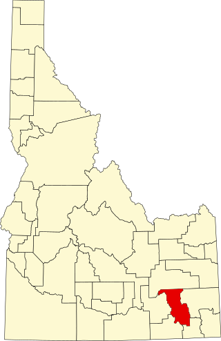
Bannock County is a county in the southeastern part of Idaho. As of the 2020 census, the population was 87,018, making it the sixth-most populous county in Idaho. The county seat and largest city is Pocatello. The county was established in 1893 and named after the local Bannock tribe. It is one of the counties with territories included in the Fort Hall Indian Reservation of the federally recognized Shoshone-Bannock Tribes.

Pocatello is the county seat and largest city of Bannock County, with a small portion on the Fort Hall Indian Reservation in neighboring Power County, containing the city's airport. It is the principal city of the Pocatello metropolitan area, which encompasses all of Bannock County in the southeastern part of the U.S. state of Idaho.

Borah Peak, also known as Mount Borah or Beauty Peak, is a mountain in the western United States and the highest summit in Idaho. One of the most prominent peaks in the contiguous United States, it is located in the central section of the Lost River Range, within the Challis National Forest in eastern Custer County. On February 11, 2021, the USGS officially recognized Mt. Borah as Idaho's only active glacier.

The Owyhee River is a tributary of the Snake River located in northern Nevada, southwestern Idaho and southeastern Oregon in the United States. It is 280 miles (450 km) long. The river's drainage basin is 11,049 square miles (28,620 km2) in area, one of the largest subbasins of the Columbia Basin. The mean annual discharge is 995 cubic feet per second (28.2 m3/s), with a maximum of 50,000 cu ft/s (1,400 m3/s) recorded in 1993 and a minimum of 42 cu ft/s (1.2 m3/s) in 1954.

The Portneuf River is a 124-mile-long (200 km) tributary of the Snake River in southeastern Idaho, United States. It drains a ranching and farming valley in the mountains southeast of the Snake River Plain. The city of Pocatello sits along the river near its emergence from the mountains onto the Snake River Plain.
Red Rock Pass is a low mountain pass in the western United States in southeastern Idaho, located in southern Bannock County, south of Downey. It is geologically significant as the spillway of ancient Lake Bonneville. It is traversed by U.S. Route 91 at an elevation of 4,785 feet (1,458 m) above sea level, bounded by two mountain ranges; the Portneuf to the east and the Bannock to the west.

Interstate 15 (I-15) is a part of the Interstate Highway System that runs from San Diego, California, to Sweetgrass, Montana. In Idaho, the Interstate Highway runs exactly 196 miles (315 km) from the Utah state line near Woodruff north to the Montana state line at Monida Pass. I-15 is the primary north–south highway of Eastern Idaho. The Interstate Highway connects Pocatello and Idaho Falls, the fourth and fifth largest cities in Idaho, and the smaller county seats of Malad City, Blackfoot, and Dubois. I-15 connects all of those cities with Salt Lake City to the south and Butte to the north. The Interstate has business loops through McCammon, Inkom, Pocatello, Blackfoot, and Idaho Falls.

The Albion Mountains are a mountain range in the U.S. states of Idaho (~99%) and Utah (~1%), spanning Cassia County, Idaho and barely reaching into Box Elder County, Utah. The highest point in the range is Cache Peak at 10,339 feet (3,151 m), and the range is a part of the Basin and Range Province. Most of the mountains are part of the Albion Division of the Minidoka Ranger District of Sawtooth National Forest.

The South Fork Salmon River is an 86-mile (138 km) tributary of the Salmon River in Idaho and Valley Counties in central Idaho. The river drains a rugged, lightly populated wilderness watershed in the Salmon River Mountains. It is the second-largest tributary of the Salmon River, after the Middle Fork.
Marsh Creek is a 56-mile-long (90 km) tributary of the Portneuf River in Bannock County, Idaho, United States.
Chinese Peak is a summit in Bannock County, Idaho, in the United States. This peak is the highest point in the portion of the Portneuf Range called the Pocatello Range. With an elevation of 6,791 feet (2,070 m), Chinese Peak is the 1069th highest summit in the state of Idaho. The peak is a fire lookout site and a road/bike trail leads to the top.
Gentile Valley is a valley in Caribou and Franklin counties in Idaho, United States.
Strevell is a ghost town in Cassia County, Idaho, United States, approximately one mile (1.6 km) north of the Utah state line and roughly 23 miles (37 km) south–southeast of Malta. It is located in the Raft River Valley along the former routing of U.S. Route 30S, and later the former routing of Idaho State Highway 81.
The Raft River Valley is a valley in Cassia County, Idaho and Box Elder County, Utah in the United States.
Malta Range was the original and former name for the combined Cotterel Mountains and Jim Sage Mountains, both of which are subranges of the Albion Mountains in Cassia County, Idaho, United States. However, it was later determined that they were two separate subranges, and the new names were applied accordingly.
The Jim Sage Mountains are a small mountain range in Cassia County, Idaho, United States, that are subrange of the Albion Mountains.

The Cotterel Mountains are a small mountain range in Cassia County, Idaho, United States, that are subrange of the Albion Mountains.

The Bannock Range is a mountain range situated in southern Idaho, near the Idaho-Utah border. 28 named mountains are located within the boundaries of the range, the tallest sitting at an elevation of 9,300 feet (2,800 m).
