Portsmouth, Great Falls and Conway Railroad

Last updated
Portsmouth, Great Falls and Conway Railroad
North Conway Railway Station.jpg
North Conway station, built in 1874
Overview
Locale New Hampshire
Dates of operation18711890
Successor Boston and Maine Railroad
Technical
Track gauge 4 ft 8+12 in (1,435 mm) standard gauge
Length67.1 miles (108.0 km)
Route map

Contents

BSicon CONTg@G.svg
Mountain Division to Hazens
BSicon eSPLa.svg
0.0
Intervale
BSicon evUSTr.svg
Mountain Junction
BSicon vSTR-STRl.svg
BSicon CONTf@Fq.svg
Mountain Division to Redstone
BSicon SHI1+r.svg
BSicon BUE-us.svg
1.0
U.S. 302/NH 16
BSicon BHF.svg
1.2
North Conway
BSicon hKRZWae.svg
3.4
Saco River
BSicon BUE-us.svg
4.8
West Side Road
BSicon hKRZWae.svg
6.0
Swift River
BSicon exCONTg@Gq.svg
BSicon eABZg+r.svg
Swift River Railroad
BSicon BUE-us.svg
6.8
NH 16
BSicon KBHFxe.svg
7.0
Conway, Conway Scenic Railroad
BSicon exBUE-us.svg
8.2
NH 113
BSicon ENDExa.svg
10.7
Silver Lake Railroad
BSicon KBHFxe.svg
13.7
Silver Lake
BSicon exBUE-us.svg
13.8
NH 113
BSicon exBUE-us.svg
14.3
NH 41
BSicon exBUE-us.svg
18.4
NH 41
BSicon exBHF.svg
18.7
West Ossipee
BSicon exhKRZWae.svg
19.1
Chocorua River
BSicon exBUE-us.svg
21.4
NH 16
BSicon exhKRZWae.svg
22.4
Lovell River
BSicon exBHF.svg
24.3
Center Ossipee
BSicon exhKRZWae.svg
24.8
Dan Hole River
BSicon exBHF.svg
29.2
Ossipee
BSicon exSKRZ-G2h.svg
NH 28
BSicon ENDExa.svg
New Hampshire Northcoast
BSicon ABZg+l.svg
BSicon CONT1+r.svg
Spur to gravel pit
BSicon SKRZ-G2h.svg
NH 16
BSicon eBHF.svg
37.3
East Wakefield
BSicon BUE-us.svg
NH 153
BSicon BUE-us.svg
NH 153
BSicon exCONTg@Gq.svg
BSicon eABZg+r.svg
Wolfeboro Railroad
BSicon eBHF.svg
42.6
Sanbornville
BSicon BUE-us.svg
NH 109
BSicon hKRZWae.svg
Branch River
BSicon hKRZWae.svg
Branch River
BSicon BUE-us.svg
NH 153
BSicon hKRZWae.svg
Branch River
BSicon BUE-us.svg
NH 125
BSicon eBHF.svg
47.0
Union
BSicon hKRZWae.svg
Jones Brook
BSicon SKRZ-G2h.svg
NH 16
BSicon WDOCKSaq.svg
BSicon hSTRae.svg
BSicon WDOCKSeq.svg
Milton Pond
BSicon hKRZWae.svg
Salmon Falls River; Maine
BSicon hKRZWae.svg
Salmon Falls River; New Hampshire
BSicon eBHF.svg
52.6
Milton
BSicon SKRZ-G2h.svg
NH 125
BSicon SKRZ-G2h.svg
NH 75
BSicon hKRZWae.svg
Great Brook
BSicon eBHF.svg
55.5
Hayes (North Rochester)
BSicon SKRZ-G2h.svg
U.S. Route 202/NH 11
BSicon BUE-us.svg
NH 125
BSicon eBHF.svg
60.5
Rochester
BSicon BUE-us.svg
NH 9
BSicon eBHF.svg
67.1
Somersworth
BSicon CONTg@Gq.svg
BSicon xABZgr.svg
to Pan Am Railways Freight Main Line
via Somersworth Branch
BSicon exCONTf.svg
Original route to Jewett, Maine

The Portsmouth, Great Falls and Conway Railroad (PGF&C) (later known as the Conway Branch of the Boston and Maine Railroad) is a former rail line between Rollinsford and Intervale, New Hampshire, in the United States. At Rollinsford, the line connected to other lines to provide service between the White Mountains and coastal cities such as Boston. At Intervale, it connected to the Mountain Division of the Maine Central Railroad. The rail line takes its name from the city of Portsmouth, near its southern terminus; the city of Somersworth (formerly known as "Great Falls"); and the town of Conway, near its northern terminus. Today, the infrastructure of the former PGF&C is owned by different entities, including the State of New Hampshire, the Conway Scenic Railroad, and the New Hampshire Northcoast Corporation. Some segments are still operated as freight or heritage railways, while other segments are being maintained as rail trails.

History

Portsmouth, Great Falls and Conway Railroad
Map
1912 postcard of Burleyville station Burleyville station 1912 postcard.jpg
1912 postcard of Burleyville station

The PGF&C was founded as the Great Falls and Conway Railroad on June 19, 1844, as an extension of the Great Falls and South Berwick Railroad, founded in 1841 and opened in 1854. The two railways were consolidated on December 30, 1848. On February 28, 1849, the first segment from Great Falls (now Somersworth) to Rochester was opened. In 1850, it was extended to South Milton, and in 1855 it was extended to Union. Further works were delayed due to financial problems.

On June 30, 1865, the railway was re-established as the Portsmouth, Great Falls and Conway Railroad, and work on the railway resumed. In 1870, the Eastern Railroad leased the PGF&C, and on October 1, 1878, it renewed the lease for 60 years. The line continued growing after Eastern's lease. In 1871, it was extended to West Ossipee, and in 1872 it was extended to North Conway. By 1875, it was extended to Intervale, where it connected with the recently opened Portland and Ogdensburg Railway. Finally, on May 9, 1890, the Portsmouth, Great Falls & Conway was absorbed into the Boston & Maine, which operated it as its Conway Branch.

Abandonment came in two phases, with the first taking place in 1941. This closed the original route from Somersworth to Jewett station in South Berwick, Maine, where it had joined the Eastern Route (formerly the Eastern Railroad) to reach Portsmouth. The current section between Rollinsford and Somersworth was originally a branch built by the B&M to reach the mills in Great Falls.

The second abandonment came in 1972 when the section from Mt. Whittier (West Ossipee) to Intervale was abandoned after the last train departed North Conway, on October 31, 1972. (The last train to depart Intervale was about a week before when the B&M picked up equipment dropped off by the MEC for the soon-to-be Conway Scenic Railroad.) The Conway Scenic Railroad purchased the line within the town of Conway two years later, and began operating on August 4, 1974. The Boston and Maine retained ownership of the line, including the abandoned portion, which was sold off in sections, with the final section (the Route 28 overpasses in Ossipee to the Madison town line) being sold to the state in 2001; this also included the small section in Albany, New Hampshire. The section from Mt. Whittier south to the NHN property line (the Route 28 overpasses) was officially abandoned in the mid 1990s.

Current status

The former Intervale station, now converted to a private residence Intervale station, Intervale NH, July 2013.JPG
The former Intervale station, now converted to a private residence

The northernmost 7 miles (11 km) of the rail line between Conway and the Mountain Division in Intervale are owned by the Conway Scenic Railroad. This heritage railway operates seasonal passenger trains on this and also on a portion of the Mountain Division. The Conway Scenic Railroad allows the use of its portion of the Conway Branch by snowmobilers outside of its operating season.

In 1986, the New Hampshire Northcoast Railroad (NHN) purchased the line between Rochester and Ossipee, and began operating the line as a freight railway. The section south of Rochester to the terminus in Rollinsford, just outside Dover, was sold to the NHN in 1994, ending Boston & Maine operation of the Conway Branch. NHN mostly uses the tracks to carry quarried sand to its parent company Boston Sand & Gravel in Boston.

In 2001, the 21-mile (34 km) section between New Hampshire Route 28 in Ossipee and West Main Street in Conway was purchased by the state of New Hampshire, and the New Hampshire Division of Parks and Recreation now maintains this section as the Conway Branch Recreational Rail Trail. [1] [2] The railroad in this section is abandoned, and roads are paved over the rails, but much of the rails are still in place, as there is no trail surface. This rail trail is used by hikers and snowmobilers. The Cotton Valley Rail Trail Club uses about 8 miles (13 km) of the track in the Ossipee area for recreational use of speeders, between Route 28 and Route 16.

In 2007, the Silver Lake Railroad began operating small, seasonal tourist trains along 3 miles (5 km) of track in Madison, using large speeders.

Related Research Articles

<span class="mw-page-title-main">Bartlett, New Hampshire</span> Town in New Hampshire, United States

Bartlett is a town in Carroll County, New Hampshire, United States. The population was 3,200 at the 2020 census, up from 2,788 at the 2010 census. Bartlett includes the unincorporated community of Glen as well as portions of the communities of Kearsarge and Intervale, which the town shares with the neighboring town of Conway. It is set in the White Mountains and is surrounded by the White Mountain National Forest. It is home to the Attitash Mountain Resort and the Story Land theme park.

<span class="mw-page-title-main">Wakefield, New Hampshire</span> Town in New Hampshire, United States

Wakefield is a town in Carroll County, New Hampshire, United States. The population was 5,201 at the 2020 census. The town includes the villages of Wakefield Corner, East Wakefield, North Wakefield, Sanbornville, Union, Woodman and Province Lake. Wakefield Corner, popular with tourists, is a picturesque hilltop village of antique buildings. The state of Maine is on the eastern border of Wakefield.

<span class="mw-page-title-main">Rollinsford, New Hampshire</span> Town in New Hampshire, United States

Rollinsford is a town in Strafford County, New Hampshire, United States. The population was 2,597 at the 2020 census. The main village in town was once known as "Salmon Falls Village".

<span class="mw-page-title-main">Somersworth, New Hampshire</span> City in New Hampshire, United States

Somersworth is a city in Strafford County, New Hampshire, United States. The population was 11,855 at the 2020 census. Somersworth has the smallest area and third-lowest population of New Hampshire's 13 cities.

<span class="mw-page-title-main">Boston and Maine Railroad</span> Former railroad in New England

The Boston and Maine Railroad was a U.S. Class I railroad in northern New England. Originally chartered in 1835, it became part of what was the Pan Am Railways network in 1983.

<span class="mw-page-title-main">White Mountains Region</span>

The White Mountains Region is a tourism region designated by the New Hampshire Division of Travel and Tourism. It is located in northern New Hampshire in the United States and is named for the White Mountains, which cover most of the region. The southern boundary of the region begins at Piermont on the west, and runs east to Campton, then on to Conway and the Maine border. The northern boundary begins at Littleton and runs east to Gorham and the Maine border. The region to the north is known as the Great North Woods Region, which should not be confused with the larger and more general Great North Woods.

North Coast or Northcoast may refer to :

<span class="mw-page-title-main">Maine Central Railroad</span> Defunct American Class I railway

The Maine Central Railroad was a U. S. class 1 railroad in central and southern Maine. It was chartered in 1856 and began operations in 1862. By 1884, Maine Central was the longest railroad in New England. Maine Central had expanded to 1,358 miles (2,185 km) when the United States Railroad Administration assumed control in 1917. The main line extended from South Portland, Maine, east to the Canada–United States border with New Brunswick, and a Mountain Division extended west from Portland to St. Johnsbury, Vermont, and north into Quebec. The main line was double track from South Portland to Royal Junction, where it split into a "lower road" through Brunswick and Augusta and a "back road" through Lewiston, which converged at Waterville into single track to Bangor and points east. Branch lines served the industrial center of Rumford, a resort hotel on Moosehead Lake and coastal communities from Bath to Eastport.

<span class="mw-page-title-main">New Hampshire Route 16</span> North-south state highway in New Hampshire, US

New Hampshire Route 16 is a 154.771-mile (249.080 km), north–south state highway in New Hampshire, United States, the main road connecting the Seacoast region to the Lakes Region and the White Mountains. Much of its length is close to the border with Maine. The section from Portsmouth to Milton is a controlled-access toll highway known as the Spaulding Turnpike. Between Milton and Chocorua, and between Conway and Glen, it is known as the White Mountain Highway. It is known as Chocorua Mountain Highway between Chocorua and Conway and various other local names before crossing into Maine about 20 miles (32 km) south of the Canadian border. Portions of NH 16 run concurrent with U.S. Route 4 (US 4), US 202, NH 25, and US 302, and US 2.

<span class="mw-page-title-main">New Hampshire Northcoast Corporation</span>

The New Hampshire Northcoast Corporation is a Class III railroad owned by Boston Sand & Gravel and offering freight service in parts of New Hampshire and Massachusetts in the United States. The company owns 43 miles (69 km) of the former Boston and Maine Corporation's Conway Branch between Rollinsford and Ossipee, New Hampshire. The railroad's primary traffic is quarried sand. It interchanges cars with CSX in Dover, New Hampshire; the cars are then taken to the Boston Sand & Gravel plant in Charlestown, Massachusetts.

<span class="mw-page-title-main">Conway Scenic Railroad</span> Heritage railroad in North Conway, NH, US

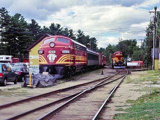
The Conway Scenic Railroad is a heritage railroad in North Conway, New Hampshire, owned by Profile Mountain Holdings Corp. The railroad operates over two historic railway routes: a line from North Conway to Conway that was formerly part of the Conway Branch of the Boston and Maine Railroad, and a line from North Conway through Crawford Notch to Fabyan that was once part of the Mountain Division of the Maine Central Railroad. The Conway line is owned by Conway Scenic, and the Mountain Division is owned by the State of New Hampshire.

<span class="mw-page-title-main">Eastern Railroad</span>

The Eastern Railroad was a railroad connecting Boston, Massachusetts to Portland, Maine. Throughout its history, it competed with the Boston and Maine Railroad for service between the two cities, until the Boston & Maine put an end to the competition by leasing the Eastern in December 1884. Much of the railroad's main line in Massachusetts is used by the MBTA's Newburyport/Rockport commuter rail line, and some unused parts of its right-of-way have been converted to rail trails.

<span class="mw-page-title-main">Mountain Division</span> Former railroad line owned and operated by the Maine Central Railroad

The Mountain Division is a railroad line that was once owned and operated by the Maine Central Railroad (MEC). It stretches from Portland, Maine on the Atlantic Ocean, through the Western Maine Mountains and White Mountains of New Hampshire, ending at St. Johnsbury, Vermont in the Northeast Kingdom. The line was abandoned in 1983 by MEC's successor, Guilford Transportation Industries (GTI). Guilford retained a stub between Portland and Westbrook. A section in New Hampshire remains in use by heritage railway Conway Scenic Railroad.

<span class="mw-page-title-main">North Conway station</span>

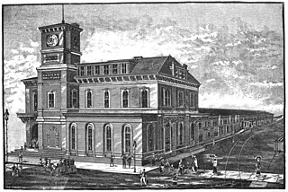
North Conway station is a railway station located in North Conway, New Hampshire. Built in 1874, the depot was designed by Nathaniel J. Bradlee in an eclectic Russian Victorian style. The station is also the terminus for the Conway Scenic Railroad. Northwest of the station stands a roundhouse, which now houses the Scenic Railroad's rolling stock; it was built around the same time as the station. The yard and depot were added to the National Register of Historic Places in 1979 as North Conway Depot and Railroad Yard.

The Portsmouth and Concord Railroad was a railroad in New Hampshire that existed under various names from 1845 to 1945.

The Portland & Rochester Railroad, established in 1867, was an important predecessor railway of the Rochester to Portland branch line of the Boston and Maine Railroad. It was founded in the merger of several smaller shortline rail transport companies, the oldest being the shortline York and Cumberland Railroad which was formed in 1846 to connect the seaport facilities of Portland, Maine, to the water powered manufacturing and textile industries along the Quampheagan Falls on the Salmon Falls River in the twin towns of South Berwick, Maine, and Rollinsford, New Hampshire .

<span class="mw-page-title-main">Boston Sand & Gravel</span>

Boston Sand and Gravel is a supplier of ready-to-pour concrete, concrete blocks, sand, and crushed stone, with operations and subsidiaries around eastern Massachusetts and New Hampshire in the United States.

<span class="mw-page-title-main">Wolfeboro Railroad</span>

The Wolfeboro Railroad or Wolfeborough Railroad is a former short line that provided service to the summer resort town of Wolfeboro, New Hampshire on Lake Winnipesaukee.

References

  1. "Conway Branch Railroad Line Feasibility Study" (PDF). 2004-06-30. Retrieved 2014-11-20.
  2. "New Hampshire Division of Parks and Recreation: Conway Branch Recreational Rail Trail". 2014. Retrieved 2014-11-20.