Potentilla hickmanii (called Hickman's potentilla or Hickman's cinquefoil) is an endangeredperennialherb of the rose family. This rare plant species is found in a narrowly restricted range in two locations in coastal northern California, in Monterey County, and in very small colonies in San Mateo County. This small wildflower, endemic to western slopes of the outer coastal range along the Pacific Ocean coast, produces bright yellow blossoms through spring and summer.
This species was formerly thought to be growing in Sonoma County, but that population has been recently reclassified as another species, Potentilla uliginosa, and is presumed extinct in that county.[4]
This plant, along with many other threatened species in the northern California Floristic Province, has been designated as a species meriting protection by the U.S. government, state of California, local governments, and private conservation groups. These designations have led to blueprints for protection of Hickman's potentilla in the form of official endangerment classifications and a species recovery plan, the latter promulgated by the U.S. Fish and Wildlife Service.
Description
P. hickmanii is found on Montara Mountain below 135 m in elevation, at the extreme east (right) of this image.
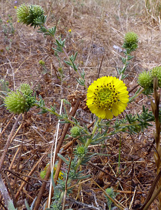
P. hickmanii is a long-lived, rosetted, nonglandular flowering plant with a thick taproot.[5] The stem is prostrate, 5–25 centimetres (2.0–9.8in) long.[5] Blooming occurs between April and August. The hypanthium is 3–6mm wide, with yellow obchordate petals 6–11mm in length. Up to 10 inflorescences may present in a single plant. Filaments are typically 1.5 to 4.0mm in length, while anthers are only about 1.0mm in size; moreover, the pistils generally number about 10 and the slender styles are about 2–3mm long.[6]
The somewhat subglabrous leaves are pinnately compound into generally six paired, palmately cleft leaflets. These basal leaves range from 3–17 centimetres (1.2–6.7in) in length[5] with individual leaflets 2–8mm long and about 2mm wide.[citation needed] Four to seven leaflets occur per side, in a separated or overlapped configuration. The leaflets are wedge-shaped, typically having three or four teeth (lobes) and originate from about halfway along the leaf stem. The smooth fruits are about 2mm in diameter and tan in color, looking like miniature watermelon seeds.
Distribution and habitat
Coastal habitat near the vicinity of Vicente Creek, Moss Beach
P. hickmanii is currently known to occur in two coastal locations. The Federal Register documents colonies on the Monterey Peninsula and at another area in coastal San Mateo County.[7] The Monterey population is within the municipal boundaries of the city of Monterey, growing in a native grassland opening of the Monterey pine forest at an old summer camp site. Plantings have been made, as attempts to establish new colonies in Monterey County at two areas the Point Lobos State Reserve, but those plantings failed by the summer of 2011 from the invasion of European weed grasses, and by the plantings situated too far from where the plants could easily be monitored or managed, and by planting in one site that was too wet for the species to survive.[8]
Another coastal colony was discovered in Moss Beach, California, in 1933 in a wetland area at the mouth of San Vicente Creek; this colony was presumed extinct by at least the 1970s. Another population in San Mateo County was discovered in 1995 on the south slopes above Martini Creek (USGS quad reference Montara Mountain 3712254), on private land by biologists conducting surveys for the Devil's Slide highway project.[9] In all cases, the populations are found between 10 and 135 m above sea level. The habitat for this species includes native grassland meadow openings in pine forests, coastal bluff native perennial grasslands, and under pine trees in duff. The key to the habitat for this species is the decomposed granite substrate that lies directly under the very fine-grained grassland topsoil.
History
The famous Lone Cypress tree, located 2 km south of the last P. hickmanii population in Monterey County
The Monterey Peninsula, discovery site of P. hickmanii, is in a native grassland opening within the Monterey pine forest. The peninsula is influenced by a marine climate that is pronounced due to the upwelling of cool water from the Monterey submarine canyon. Rainfall is 40 to 50cm per year, but summer fog drip is a primary source of moisture for plants that would otherwise not be able to persist with such low precipitation. Some taxa, such as the coastal closed-cone pines and cypresses are relict stands, e.g. species that once extended more widely in the mesic climate of the late Pleistocene period, but then retreated to small pockets of cooler and wetter conditions along the coast ranges during the hotter, drier early Holocene period between 6000 and 2000 BC.[10]
Alice Eastwood discovered P. hickmanii in 1900 on the Monterey Peninsula, a region then considered the fringe of civilization. The Big Sur wilderness lay just beyond, unpenetrated by any roads at that time. Eastwood, curator of botany at the California Academy of Sciences in San Francisco was a pioneer biologist in exploring this remote area. On an expedition to amass specimens of rare plants from this southern reach of Monterey County, she retrieved a specimen of this previously unrecorded plant and named this species after J. B. Hickman. Hickman was her guide on that collecting trip, and was the horticultural commissioner of Monterey County.[11]
Conservation status
In 1973, the state of California recognized Hickman's potentilla as an endangered species. In the early to mid 1990s, a series of steps occurred that led to federal classification as an endangered species. Certain land development proposals came before the city of Monterey related to pine forest habitat area. In preparing an environmental impact report, information on occurrences of Hickman's potentilla was published.[12][13] Subsequently, in 1995, the U.S. Fish and Wildlife Service (FWS) acted on this new information regarding a species that some thought extinct, and promulgated a notice of intent to classify the species as endangered.[13]
In 1998, the FWS officially classified Hickman's potentilla as endangered.[3] After the FWS nomination process, further colonies in San Mateo and Sonoma Counties became defined. This chain of events illustrates the role of the environmental impact statement in elucidating scientific information germane to the understanding of an entire species, beyond the intended role of analyzing effects on the physical environment of a specific project.
P. hickmanii continues to be pressured by urban development, especially on the Monterey Peninsula, with chief elements of golf courses and housing to support the expanding human population. These pressures are partially mitigated by species protection and recovery plans, the latter of which are recognized by the county, local cities, Association of Monterey Bay Area Governments, and the state of California. However, the lack of any funding to implement any recovery plans causes the plans to only exist on paper, and the species is still in serious jeopardy without any annual action or recovery activities on the ground.
The federal recovery plan (internationally called biodiversity action plan) is general in nature, calling for more natural-history study, population surveys, generalized protection, and a vague reference to new plantings. One of the best efforts to enhance the species may come from a program that is seemingly unaware of the species. The Fitzgerald Marine Reserve master plan calls for[14] natural vegetative enhancement of Vicente Creek (exact location of the 1933 colony), including removal of fill and debris from the creek and extirpation of invasive plants. A chief rationale for this plan is protection of the California red-legged frog, also an endangered species.
As a further measure of protection, Monterey County, California, has explicitly included[15] Hickman's potentilla as a species to be protected via its local coastal program pursuant to California requirements. While the species is listed as federally and state endangered, the California Native Plant Society has set the further designation of "seriously endangered". This appellation is provided to any plant that has fewer than six occurrences, exists on less than 2000 acres (8km2) of land area, or has fewer than 1000 known organisms. Hickman's potentilla satisfies the first criterion.
The San Mateo County population occurs in small, scattered native-grassland sites on Montara Mountain and are currently threatened with extinction by the encroaching invasive European weed grasses such as Brachypodium, Vulpia, and Holcus species and two species of Briza or rattlesnake grass, which crowd out the plants. The annual weeds Plantago and flax and the perennial weeds cat's ears and Queen Anne's lace are also invading its habitat. Near one population, eight different weeds cover 45% of the area, and the seven other native plants of the native grassland community, make up 55% cover. Each year, all the weeds need to be cleared away at a sufficient distance from the P. hickmanii plants, and the area restored to as close to 100% native plant cover as possible, otherwise some of these populations could face extinction soon.
An even more formidable challenge for the future of the San Mateo County populations will be the taller and more aggressive perennial exotic invasive grass, Harding grass (Phalaris), growing 2 m tall and forming a solid stand on the next mountain ridge, only a few hundred meters from the two largest colonies; this nearby infestation has the appearance of a weed-tsunami, engulfing every native plant in its path, and a tiny 5-cm-tall plant does not have a chance without assistance.[16]
Plant counts for each in situ population for this species:
Monterey County, Indian Village, Pebble Beach, between 1979 and 2008, the population varied between five and 35 plants, and a reference was made to outplanted P. hickmanii existing at this site in the 2009 FWS report.[17] However, the original population in 2011 is presumed extinct at this site and the existing plants may be the survivors from plantings of nursery-raised seedlings grown in potting soil. The nursery-grown origin of individual plants could be confirmed, by examining the roots and finding remains of potting soil around such plants. In winter, the plants that still have any potting soil around their roots may benefit by having the artificial soil removed and the plants replanted bare-rooted, as the potting soil could wick moisture from around the roots in summer.[18]
Monterey County, Eastwood collection, unable to locate site[19]
Monterey County, Pacific Grove near the reservoir on road to Cypress point, was last seen 1968, and is presumed extinct.[20]
Monterey County, Point Lobos State Reserve, experimental plantings at two sites, is presumed extinct.[21]
San Mateo County, Montara Mountain, north of town of Montara, eight populations were found, counted, and mapped in 2008.[22] Population #1= 4 plants, Pop.#2=11 plants, Pop.#3=about 1,060 plants, Pop.#4=about 2,000 plants, Pop.#5=26 plants, Pop.#6=12 plants, Pop.#7=3 plants, Pop.#8=45 plants. UPDATE: By summer 2011, the species largest population #4, as well as #6, 7, and 8, were presumed extinct, as these populations were buried under a 2-m-tall, solid cover of exotic Harding grass. Population #3, that covering 30 by 230 m in 2008, had diminished to only 14 by 20 m, and only about 300 plants were observed.[23]
San Mateo County, Moss Beach near Point Montara, presumed extinct, last seen in 1933.[24]
Some ex situplants may exist, grown in nurseries for research or study, for example, or at universities or botanical gardens, but those numbers are unknown.
Updated observations and conservation status
Update (2013) on populations in San Mateo County, Montara Mountain, north of town of Montara: Specific consistent counts of this species are difficult due to the low stature, extended flowering period, and difficult terrain, making year-to-year comparisons problematic. The 2013 surveys have clearly shown that population 4 still exists above the existing Harding grass invasion, with at least 500 plants found in this area.[25] In 2014, hand weeding of the area around population during summer 2011 has significantly lowered the weed plant cover of the area, with the big rattlesnake grass (Briza) originally at 61% cover in 2011 is now down to 1% cover in 2014. The hillside of Harding grass where population 4 exists was mowed in summer 2014.[26]
Related Research Articles
Moss Beach is a coastal census-designated place in San Mateo County, California, with a year 2020 census population of 3,214. Located in Moss Beach are the Fitzgerald Marine Reserve, a marine sanctuary; the Half Moon Bay Airport, the historic Moss Beach Distillery; and the Seal Cove Inn, a destination lodging property. Moss Beach is a cool coastal microclimate that gives one a sense of separation from the nearby metropolitan San Francisco Bay Area and assures that summer temperatures are generally mild.
Fitzgerald Marine Reserve is a marine reserve in California on the Pacific Ocean, located just north of Pillar Point Harbor and Mavericks in the San Mateo County community of Moss Beach. Moss Beach is located approximately 20 miles (32 km) south of San Francisco and 50 miles (80 km) north of Santa Cruz. The reserve is a 32-acre (0.13 km2) holding which extends from Montara light station at the north to Pillar Point on the south. The reserve consists of a three-mile stretch of beach, tidepool habitat, marsh, erosive bluffs, clifftop trail and cypress and eucalyptus forests. The property is owned by the State of California and managed by San Mateo County as a county park and nature preserve. The reserve is administratively assigned to be part of the Monterey Bay National Marine Sanctuary. Adjacent to and possibly within the reserve is an endangered species of butterfly, the San Bruno elfin butterfly.
Devil's Slide is a coastal promontory in California, United States. It lies on the San Mateo County coast between Pacifica and Montara. Its name comes from the rocky edges prone to accident.
The Northern California coastal forests are a temperate coniferous forests ecoregion of coastal Northern California and southwestern Oregon.
Coastal sage scrub, also known as coastal scrub, CSS, or soft chaparral, is a low scrubland plant community of the California coastal sage and chaparral subecoregion, found in coastal California and northwestern coastal Baja California. It is within the California chaparral and woodlands ecoregion, of the Mediterranean forests, woodlands, and scrub biome.
California coastal prairie, also known as northern coastal grassland, is a grassland plant community of California and Oregon in the temperate grasslands, savannas, and shrublands biome. This ecosystem is found along the Pacific Coast, from as far south as Los Angeles in Southern California to southern Oregon. It typically stretches as far inland as 100 km, and occurs at altitudes of 350 m or lower.
Holocarpha macradenia, commonly known as the Santa Cruz tarplant, is an endangered plant endemic to Northern California. Alternative common names for this plant are Santa Cruz tarweed or Santa Cruz sunflower.
San Vicente Creek is a 3.9-mile-long (6.3 km) coastal stream in northern California which flows entirely within San Mateo County and discharges to the Pacific Ocean. Its waters rise on the west facing slopes of the Montara Mountain, block and its mouth is at the unincorporated community of Moss Beach, within the Fitzgerald Marine Reserve. Historically there was a tidal marsh at its mouth, but some of this reach has been degraded by fill, especially in the construction of West Point Drive. This westernmost reach of the creek has been especially ecologically productive, and part of the reason for Fitzgerald Marine Reserve's designation on August 5, 1969, as a state reserve and was named after James V. Fitzgerald.
Martini Creek is a coastal stream whose watershed lies entirely within San Mateo County, California, United States on the western exposures of the Montara mountain block, discharging to the Pacific Ocean. It flows about 2 miles (3 km) from its source on Montara Mountain to its mouth in Montara State Beach. This stream has a drainage basin composed of open space and agricultural lands. Some of the basin has moderate to steep slopes and much of the basin habitat is northern coastal scrub, and in places almost of a pygmy forest nature.
The Mission blue is a blue or lycaenid butterfly subspecies native to the San Francisco Bay Area of the United States. The butterfly has been declared as endangered by the US federal government. It is a subspecies of Boisduval's blue.
Platanthera yadonii, also known as Yadon's piperia or Yadon's rein orchid, is an endangered orchid endemic to a narrow range of coastal habitat in northern Monterey County, California. In 1998 this plant was designated as an endangered species by the United States government, the major threat to its survival being continuing land development from an expanding human population and associated habitat loss. One of the habitats of Yadon's piperia, the Del Monte Forest near Monterey, California, is the subject of a federal lawsuit, based upon endangerment of this organism along with several other endangered species.
Montara Mountain, positioned between the unincorporated community of Montara, California, to the southwest and the city of Pacifica, California, to the north, forms the northern spur of the Santa Cruz Mountains, a narrow mountain range running the length of the San Francisco Peninsula that separates San Francisco Bay from the Pacific Ocean. Its highest point rises to 1,898 feet (579 m) above sea level. Montara and Pacifica are connected by the Tom Lantos Tunnels, which run through the Mountain.
Acanthomintha duttonii is a species of annual plant endemic to San Mateo County, California in the family Lamiaceae. It is commonly called San Mateo thornmint and is found growing on serpentine soils near the Crystal Springs Reservoir in a six-mile (10 km) long strip on the east side of Montara Mountain at elevations of approximately 150 to 300 meters.
Pentachaeta bellidiflora, the white-rayed pentachaeta or whiteray pygmydaisy, is a Californian wildflower in the genus Pentachaeta of the family Asteraceae. It is included in both the state and federal lists of endangered species.
The U.S. Fish and Wildlife Service (USFWS) has a number of programs aimed at Mission blue butterfly habitat conservation, which include lands traditionally inhabited by the Mission blue butterfly, an endangered species. A recovery plan, drawn up by the U.S. Fish and Wildlife Service in 1984, outlined the need to protect Mission blue habitat and to repair habitat damaged by urbanization, off highway vehicle traffic, and invasion by exotic, non-native plants. An example of the type of work being done by governmental and citizen agencies can be found at the Marin Headlands in the Golden Gate National Recreation Area. In addition, regular wildfires have opened new habitat conservation opportunities as well as damaging existing ones.
McNee Ranch is located in the Santa Cruz Mountains of the United States, near the unincorporated community of Montara, California in San Mateo County. The highest point in the 690-acre ranch rises to 1,898 feet above sea level. An unpaved fire road, the North Peak Access Road, accessible from the Pedro Mountain Road, provides access to the summit by hikers. The mountain has an extensive biodiversity especially on the serpentine soils of the lower slopes where such endangered species as Hickman's potentilla and San Mateo thornmint, Acanthomintha duttonii, are found. On rare occasions light snow has dusted the summit. On clear days the summit provides views of much of the San Francisco Bay Area.
Myrtle's silverspot is a medium-sized butterfly in the brush foot family (Nymphalidae), an endangered subspecies of the zerene fritillary. It is endemic to California, where it is known from only about four locations just north of the San Francisco Bay Area, including two at Point Reyes National Seashore. Its wingspan is approximately 2.2 inches (56 mm). The upper surfaces of the wings are golden brown with numerous black spots and lines. The undersides are brown, orange and tan with black lines and silver and black spots. Larvae are dark colored with many sharp branching spines on their backs. Myrtle's silverspot is larger and paler than the closely related Behrens' silverspot, which is now limited to the vicinity of Point Arena in Mendocino County. Myrtle's silverspot is also closely related to the Oregon silverspot.
Arctostaphylos montaraensis, known by the common name Montara manzanita, is a species of manzanita in the family Ericaceae.
Sidalcea hickmanii is a species of flowering plant in the mallow family known generally by the common name chaparral checkerbloom.
The Bay checkerspot is a butterfly endemic to the San Francisco Bay region of the U.S. state of California. It is a federally threatened species, as a subspecies of Euphydryas editha.
↑ Notice of Availability of a Draft Recovery Plan for Five Plants From Monterey County, CA, Federal Register: May 13, 2002, Volume 67, Number 92, Pages 32003-32004
↑ Dremann, Craig Carlton. September 2011 Field notes, unpublished. Notebook 234, pages 12-14.
↑ Devil's Slide Improvement Project, Draft Second Supplemental Environmental Impact Statement, Route 1 from Half Moon Bay Airport to Linda Mar Boulevard in Pacifica, San Mateo County, California, Caltrans District 4, San Francisco, Ca. (1987)
↑ C.I. Millar, Reconsidering the Conservation of Monterey Pine. Fremontia 26(3):12–16 (1998)
↑ C.M. Hogan, G. Deghi, M. Papineau et al., Environmental Impact Report for the Pebble Beach Properties project by Del Monte Forest, Earth Metrics Inc. Prepared for the city of Monterey and State of California Clearinghouse (1992)
This page is based on this Wikipedia article Text is available under the CC BY-SA 4.0 license; additional terms may apply. Images, videos and audio are available under their respective licenses.