East Fallowfield Township is a township in Chester County, Pennsylvania, United States. The population was 7,626 at the 2020 census.

Overbrook Farms is a neighborhood that is situated on the western edge of the West Philadelphia section of Philadelphia, Pennsylvania, United States. It is roughly bounded by City Avenue, 58th Street, Woodbine Avenue, and 66th Street at Morris Park.

This is a list of properties and historic districts in Kentucky that are listed on the National Register of Historic Places. There are listings in all of Kentucky's 120 counties.

Fox Chase Farm is one of two working farms in the city of Philadelphia, Pennsylvania. Formerly owned by the Wistar family, the farm is located on Pine Road in the Fox Chase neighborhood of Northeast Philadelphia on the border with Montgomery County. The farm gradually became surrounded by the city's residential neighborhoods and was purchased by the city in 1975. It is now run as an educational farm by the School District of Philadelphia.

The Wiconisco Canal was a 19th century transportation waterway, about 12 miles (19 km) long, in Dauphin County in the U.S. state of Pennsylvania. Running along the east bank of the Susquehanna River between Millersburg and Duncan's Island at the mouth of the Juniata River, the canal overcame about 42 feet (13 m) of vertical lift through the use of 7 locks.

List of the National Register of Historic Places listings in Mercer County, New Jersey

The James Thome Farm is a historic farm located in Eighty Four, Pennsylvania. It was designated as a historic residential landmark/farmstead by the Washington County History & Landmarks Foundation, and is listed on the National Register of Historic Places.

Philip Friend House is a c. 1807 historic farm house in North Bethlehem Township, Pennsylvania, US. The stone house is forty feet by thirty feet, two-story, five-bay, and gable-roofed. Contributing outbuildings include a barn, springhouse, wash house, and privy.

Robert Parkinson Farm is a historic property located in Morris Township, Pennsylvania, United States.

The John Corbley Farm, also known as Slave Gallant, is an historic American home that is located in Greene Township in Greene County, Pennsylvania.

The John Michael Farm is an historic American farm complex that is located in the Delaware Water Gap National Recreation Area in Middle Smithfield Township, Monroe County, Pennsylvania.

John Turn Farm is a historic farm complex located in the Delaware Water Gap National Recreation Area at Middle Smithfield Township, Monroe County, Pennsylvania, USA. The complex includes the lime kiln, smoke house and weave house. The property also includes the site of the demolished main farmhouse, a smaller house, a barn and garage.
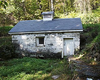
Cold Spring Farm Springhouse is a historic springhouse located in Delaware Water Gap National Recreation Area at Middle Smithfield Township, Monroe County, Pennsylvania. It was built in the late-19th century and is a one-story, rectangular fieldstone building. It measures approximately 12 by 24 feet. It has a wood shingle roof and small cupola. Also on the property is a concrete dam, built about 1909. It represents a typical springhouse of the Delaware River Valley.

The Marie Zimmermann Farm is an historic, American home that is located in the Delaware Water Gap National Recreation Area in Delaware Township, Pike County, Pennsylvania.
Broadhead Farm, also known as the Broadhead-Heller Farm and/or "Wheat Plains," is a historic home located in the Delaware Water Gap National Recreation Area at Lehman Township, Pike County, Pennsylvania. It was established in the late 1770s by Garret Broadhead (1733-1804), a soldier of the American Revolution. The main structure is a large 2+1⁄2-story, clapboard sided dwelling. It has a slate covered gable roof with dormers. The oldest section is of log construction and it was added on numerous times over the succeeding years. Also on the property are a variety of modern barns and farm outbuildings.

The Nyce Farm, also known as the Eshback Farm and Van Gordon House, is an historic, American home and farm complex that is located in the Delaware Water Gap National Recreation Area in Lehman Township, Pike County, Pennsylvania.

John Brown Farm, Tannery & Museum, 17620 John Brown Rd., Guys Mills, PA 16327, is a historic archaeological site located in Richmond Township, Crawford County, Pennsylvania. The tannery was built in 1825 by famed abolitionist John Brown (1800–1859), who lived on the site from 1825 to 1835. The tannery was about 0.25 miles (0.40 km) from the new Pennsylvania and Ohio Canal.

The White Horse Tavern, also known as the White Horse Inn and Old Swanenburg Farm, is a historic American inn and tavern located in East Whiteland Township, Chester County, Pennsylvania.

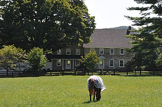
John Powell House is a historic home located in East Fallowfield Township, Chester County, Pennsylvania, United States. The house was built about 1796, and is a two-story, five-bay, stuccoed stone vernacular Federal style dwelling. It has a gable roof and a full width front porch.


