Prescott, Wisconsin

Last updated

Prescott, Wisconsin
Prescott From Point Douglas.jpg
View of Prescott from park on Point Douglas
Pierce County Wisconsin Incorporated and Unincorporated areas Prescott Highlighted.svg
Location of Prescott in Pierce County, Wisconsin.
Coordinates: 44°45′6″N92°47′35″W / 44.75167°N 92.79306°W / 44.75167; -92.79306
Country Flag of the United States.svg  United States
State Flag of Wisconsin.svg  Wisconsin
County Pierce
Government
  TypeMayor - Council
  MayorRobert Daugherty
Area
[1]
  Total2.97 sq mi (7.70 km2)
  Land2.60 sq mi (6.73 km2)
  Water0.37 sq mi (0.97 km2)
Elevation
[2]
712 ft (217 m)
Population
 (2010) [3]
  Total4,258
  Estimate 
(2019) [4]
4,295
  Density1,652.56/sq mi (638.14/km2)
Time zone UTC-6 (Central (CST))
  Summer (DST) UTC-5 (CDT)
Area code(s) 715 & 534
FIPS code 55-65375 [5]
GNIS feature ID1571918 [2]
Website prescottwi.org
Aerial view of the city PrescottWI aerial view.jpg
Aerial view of the city

Prescott is a city in Pierce County, Wisconsin at the confluence of the St. Croix River and Mississippi River. The population was 4,258 at the 2010 census, making it the second-largest city in the county after River Falls, and the largest entirely within Pierce County.

Contents

Prescott was home to the mother house of the Franciscan Servants of Jesus. The town was first settled by (and named for) Philander Prescott, who opened a trading post there in 1839.

Geography

Prescott is located at 44°45′6″N92°47′35″W / 44.75167°N 92.79306°W / 44.75167; -92.79306 (44.751567, -92.793141). [6] It is the westernmost incorporated community in Wisconsin, although rural portions of Burnett and Polk counties are further west. Prescott, along with the rest of Pierce County, is officially a part of the Minneapolis-St Paul-Bloomington MN-WI Metropolitan Statistical Area, with many residents of Prescott commuting to Minneapolis or Saint Paul for employment or education.

According to the United States Census Bureau, the city has a total area of 2.96 square miles (7.67 km2), of which, 2.59 square miles (6.71 km2) is land and 0.37 square miles (0.96 km2) is water. [7]

Transportation

Prescott is served by US 10, WIS 35 and WIS 29. US 10 runs west to the Twin Cities and east to the county seat in Ellsworth. WIS 35 runs along Wisconsin's western border. From Prescott, it runs north toward River Falls and Hudson, although County Road F provides a more direct connection to Hudson. WIS 35 runs south along the Mississippi River through rural areas all the way to La Crosse, although the highway provides easy access to Red Wing, Minnesota via US 63. WIS 29 has its western terminus at Prescott. It runs east to River Falls, Menomonie, Chippewa Falls, Wausau, and Green Bay before ending in Kewaunee.

Prescott does not have any scheduled public transportation services. The nearest public transportation is in nearby Cottage Grove, Minnesota, where Metro Transit offers express buses to Minneapolis and St. Paul on weekdays at rush hour.

Due to its location along the confluence of two navigable rivers, Prescott is a major area for private boating, but no scheduled commercial transportation options are available by river.

Amtrak train service is available in both Red Wing and St. Paul, which are both served by the Empire Builder, running between Chicago and Seattle or Portland, Oregon.

The nearest intercity bus service is provided in Hastings, Minnesota by Jefferson Lines, running between Minneapolis and Rochester.

Commercial air service is available at the Minneapolis-St. Paul International Airport in the Twin Cities.

Education

Prescott has four public schools and one parochial school. The Prescott School District operates the four public schools, which are Malone Elementary School (Grades K-2), Malone Intermediate School, (3-5) Prescott Middle School (Grades 6–8), and Prescott High School (Grades 9–12). St. Joseph's School is a private Catholic school for grades K-6. The mascot for the Prescott Public Schools is the cardinal.

Demographics

Historical population
CensusPop.Note
1860 1,031
1870 1,13810.4%
1880 975−14.3%
1890 911−6.6%
1900 1,00210.0%
1910 936−6.6%
1920 892−4.7%
1930 755−15.4%
1940 85713.5%
1950 1,00517.3%
1960 1,53652.8%
1970 2,33151.8%
1980 2,65413.9%
1990 3,24322.2%
2000 3,76416.1%
2010 4,25813.1%
2019 (est.)4,295 [4] 0.9%
U.S. Decennial Census [8]

2010 census

As of the census [3] of 2010, there were 4,258 people, 1,685 households, and 1,152 families living in the city. The population density was 1,644.0 inhabitants per square mile (634.8/km2). There were 1,813 housing units at an average density of 700.0 per square mile (270.3/km2). The racial makeup of the city was 95.8% White, 0.3% African American, 0.6% Native American, 0.4% Asian, 0.6% from other races, and 2.2% from two or more races. Hispanic or Latino of any race were 2.0% of the population.

There were 1,685 households, of which 35.9% had children under the age of 18 living with them, 53.4% were married couples living together, 10.1% had a female householder with no husband present, 4.9% had a male householder with no wife present, and 31.6% were non-families. 23.3% of all households were made up of individuals, and 7.5% had someone living alone who was 65 years of age or older. The average household size was 2.50 and the average family size was 2.97.

The median age in the city was 36.5 years. 25.9% of residents were under the age of 18; 6.6% were between the ages of 18 and 24; 29.7% were from 25 to 44; 26.7% were from 45 to 64; and 11.1% were 65 years of age or older. The gender makeup of the city was 50.4% male and 49.6% female.

2000 census

As of the census [5] of 2000, there were 3,764 people, 1,432 households, and 1,006 families living in the city. The population density was 1,860.4 inhabitants per square mile (718.3/km2). There were 1,472 housing units at an average density of 727.5 per square mile (280.9/km2). The racial makeup of the city was 98.17% White, 0.21% African American, 0.48% Native American, 0.24% Asian, 0.35% from other races, and 0.56% from two or more races. Hispanic or Latino of any race were 1.22% of the population.

There were 1,432 households, out of which 36.6% had children under the age of 18 living with them, 56.6% were married couples living together, 9.9% had a female householder with no husband present, and 29.7% were non-families. 22.2% of all households were made up of individuals, and 8.0% had someone living alone who was 65 years of age or older. The average household size was 2.59 and the average family size was 3.08.

In the city, the population was spread out, with 26.4% under the age of 18, 9.4% from 18 to 24, 32.8% from 25 to 44, 20.5% from 45 to 64, and 10.9% who were 65 years of age or older. The median age was 34 years. For every 100 females, there were 98.8 males. For every 100 females age 18 and over, there were 96.1 males.

The median income for a household in the city was $52,598, and the median income for a family was $60,237. Males had a median income of $37,950 versus $27,111 for females. The per capita income for the city was $22,610. About 1.6% of families and 4.6% of the population were below the poverty line, including 3.2% of those under age 18 and 9.5% of those age 65 or over.

Notable people

Related Research Articles

<span class="mw-page-title-main">Pierce County, Wisconsin</span> County in Wisconsin, United States

Pierce County is a county in the U.S. state of Wisconsin. As of the 2020 census, the population was 42,212. Its county seat is Ellsworth.

<span class="mw-page-title-main">Cadott, Wisconsin</span> Village in Wisconsin, United States

Cadott is a village in Chippewa County in the U.S. state of Wisconsin. The population was 1,437 at the 2010 census.

<span class="mw-page-title-main">Pardeeville, Wisconsin</span> Village in Wisconsin, United States

Pardeeville is a village in Columbia County, Wisconsin, United States. The population was 2,115 at the 2010 census. It is part of the Madison Metropolitan Statistical Area.

<span class="mw-page-title-main">Markesan, Wisconsin</span> City in Wisconsin, United States

Markesan is a city in Green Lake County, Wisconsin, United States. The population was 1,476 at the 2010 census. The center of population of Wisconsin is located in Markesan.

<span class="mw-page-title-main">Mauston, Wisconsin</span> City in Wisconsin, United States

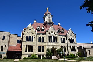
Mauston is a city in and the county seat of Juneau County, Wisconsin, United States. The population was 4,347 as of the 2020 census. It is approximately 70 miles northwest from the state capital, Madison.

<span class="mw-page-title-main">Cato, Wisconsin</span> Town in Wisconsin, United States

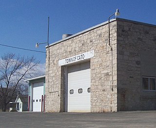
Cato is a town in Manitowoc County, Wisconsin, United States. The population was 1,616 at the 2000 census. A Manitowoc County park is located in the town which is called "Cato Falls" for a waterfall on the Manitowoc River.

<span class="mw-page-title-main">Maribel, Wisconsin</span> Village in Wisconsin, United States

Maribel is a village in Manitowoc County, Wisconsin, United States. The population was 351 at the 2010 census.

<span class="mw-page-title-main">New Richmond, Wisconsin</span> City in Wisconsin, United States

New Richmond is a city in St. Croix County, Wisconsin, United States. Its population was 10,079 as of the 2020 census.

<span class="mw-page-title-main">Stoddard, Wisconsin</span> Village in Wisconsin, United States

Stoddard is a village in Vernon County, Wisconsin, United States. The population was 840 at the 2020 census.

<span class="mw-page-title-main">Biron, Wisconsin</span> Village in Wisconsin, United States

Biron is a village in Wood County, Wisconsin, United States. The population was 839 at the 2010 census. It is the site of ND Paper's Biron Mill.

<span class="mw-page-title-main">Nekoosa, Wisconsin</span> City in Wisconsin, United States

Nekoosa is a city in Wood County, Wisconsin, United States. Its name derives from the Ho-Chunk word, "Nįįkuusra", "Nakrusa", or "Nįkusara" which translates to "running water". The population was 2,580 at the 2010 census.

<span class="mw-page-title-main">Wrightstown, Wisconsin</span> Village in Wisconsin, United States

Wrightstown is a village in Brown and Outagamie counties in the U.S. state of Wisconsin. The population was 2,827 at the 2010 census. Of this, 2,676 were in Brown County, and 151 were in Outagamie County. The village is surrounded mostly by the westernmost part of the Town of Wrightstown in Brown County. On February 28, 2002, the village annexed a portion of land within the adjacent Town of Kaukauna in Outagamie County.

<span class="mw-page-title-main">Brillion, Wisconsin</span> City in Wisconsin, United States

Brillion is a city in Calumet County in the U.S. state of Wisconsin. The population was 3,466 as of May 30, 2023. The city is located within the Town of Brillion, though it is politically independent.

<span class="mw-page-title-main">Ripon, Wisconsin</span> City in Wisconsin, United States

Ripon is a city in Fond du Lac County, Wisconsin, United States. The population was 7,863 at the 2020 census. The city is surrounded by the Town of Ripon.

<span class="mw-page-title-main">Green Lake, Wisconsin</span> City in Wisconsin, United States

Green Lake is a city in Green Lake County, Wisconsin, United States. The population was 960 at the 2010 census. The city is located on the north side of Green Lake. The city of Green Lake is the county seat for the county of Green Lake. The Town of Green Lake is located on the south side of Big Green Lake, opposite the city.

<span class="mw-page-title-main">Princeton, Wisconsin</span> City in Wisconsin, United States

Princeton is a city in western part of Green Lake County, Wisconsin, United States. The population was 1,214 at the 2010 census. The city is located within the Town of Princeton. The Fox River flows through the city, dividing the city into an east half and west half.

<span class="mw-page-title-main">Gillett, Wisconsin</span> City in Wisconsin, United States

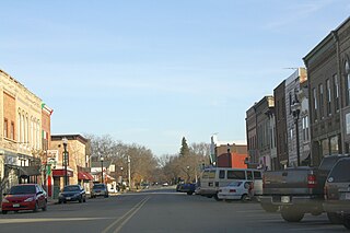
Gillett is a city in Oconto County, Wisconsin, United States. The population was 1,386 at the 2010 census. It is part of the Green Bay Metropolitan Statistical Area. The city is adjacent to the Town of Gillett.

<span class="mw-page-title-main">Oconto, Wisconsin</span> City in Wisconsin, United States

Oconto is a city in Oconto County, Wisconsin, United States. The population was 4,609 at the 2020 census. It is part of the Green Bay Metropolitan Statistical Area. The city is located partially within the town of Oconto.

<span class="mw-page-title-main">Oconto Falls, Wisconsin</span> City in Wisconsin, United States

Oconto Falls is a city in Oconto County, Wisconsin, United States. The population was 2,891 at the 2010 census. It is part of the Green Bay Metropolitan Statistical Area.

<span class="mw-page-title-main">River Falls, Wisconsin</span> City in Wisconsin, United States

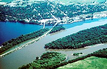
River Falls is a city in Pierce and St. Croix counties in the U.S. state of Wisconsin. It is adjacent to the Town of River Falls in Pierce County and the Town of Kinnickinnic in St. Croix County. River Falls is the most populous city in Pierce County. The population was 16,182 at the 2020 census, with 11,851 residing in Pierce County and 3,149 in St. Croix County. It is part of the Minneapolis-St. Paul metropolitan area and located approximately 30 miles (48 km) east of the center of that region.

References

  1. "2019 U.S. Gazetteer Files". United States Census Bureau. Retrieved August 7, 2020.
  2. 1 2 "US Board on Geographic Names". United States Geological Survey. October 25, 2007. Retrieved January 31, 2008.
  3. 1 2 "U.S. Census website". United States Census Bureau . Retrieved November 18, 2012.
  4. 1 2 "Population and Housing Unit Estimates". United States Census Bureau. May 24, 2020. Retrieved May 27, 2020.
  5. 1 2 "U.S. Census website". United States Census Bureau . Retrieved January 31, 2008.
  6. "US Gazetteer files: 2010, 2000, and 1990". United States Census Bureau. February 12, 2011. Retrieved April 23, 2011.
  7. "US Gazetteer files 2010". United States Census Bureau. Archived from the original on January 25, 2012. Retrieved November 18, 2012.
  8. "Census of Population and Housing". Census.gov. Retrieved June 4, 2015.
  9. Alvin Baldus at Biographical directory of United States Congress