Proposals for new tram lines in Edinburgh

Last updated

Various studies, from 1989 onwards, considered the reintroduction of trams to Edinburgh. [1] In 2001, a proposal for a new Edinburgh Trams network envisaged three routes across the city, Lines 1, 2 and 3. Line 1 was a circular route running around the northern suburbs, with the other two forming radial lines running out to Newbridge in the west and to Newcraighall in the south respectively. [2] All lines would run through the city centre.

Contents

Line 3 was later shelved due to lack of Scottish Parliament approval. Lines 1 and 2 were combined and split into three phases, with Phase 1 being further divided into Phase 1a and 1b. Phases 1b, 2 and 3 were not funded, and as of 2013 only a truncated section of the planned Phase 1a line (running from the airport to the city centre) has been constructed.

Line 1 (North Edinburgh)

Diagram of Line 1 proposed in 2001 Edinburgh Trams line 1.png
Diagram of Line 1 proposed in 2001
The planned route of the tram line along the waterfront at Granton Wardie Cottages, Lower Granton Road, Edinburgh - geograph.org.uk - 1269378.jpg
The planned route of the tram line along the waterfront at Granton

Line 1 was planned to be a 15.25-kilometre (9.48 mi) circular route with 22 stops running around the northern suburbs, following a route from the City Centre, St Andrew Square, York Place, Picardy Place, down Leith Walk to Leith and Newhaven. The line would then run along the waterfront to Granton, where it would then loop back, taking over the disused Caledonian Railway route between via Crewe Toll to Wester Coates and Haymarket. Upon reaching Haymarket, trams will return to on-street running mode and head back along Princes Street.

Line 1 comprised 2.3 kilometres (1.4 mi) of on-street track integrated with other traffic, 2.7 kilometres (1.7 mi) of segregated track running along existing roads, and 10.5 kilometres (6.5 mi) separate tramway. The on-street sections of track would be in the centre of the road in some locations and at the kerbside in others. On the disused line to Granton, the tram line would be integrated with cycle and pedestrian pathways along the Roseburn wildlife corridor. [3]

In the initial Phase 1a of the project, only the Newhaven-Leith Walk-Princes Street section of this route was included, with trams then continuing west to the airport (Line 2 route). Further construction of the Line 1 loop (Phase 1b of the project) was cancelled in 2009 due to financial constraints, postponing construction of the Haymarket-Granton section of this line indefinitely. [4] Phase 2, which would complete the loop with a line from Granton Square to Newhaven, also remains unfunded.

NamePhaseTransport InterchangeServes
Haymarket Phase 1a National Rail logo.svg Haymarket railway station
BSicon BUS2.svg Lothian Buses
BSicon TRAM1.svg Line 2 (West Edinburgh)
Edinburgh International Conference Centre
St Mary's Music School
Shandwick Place Phase 1a
Princes Street Phase 1a Princes Street
National Gallery of Scotland
St Andrew Square Phase 1a BSicon BUS2.svg Lothian Buses
Edinburgh Bus Station
National Rail logo.svg Waverley Station
St Andrew Square
St. James Centre
Picardy Place Phase 1a Omni Centre
Edinburgh Playhouse
McDonald Road Phase 1a Easter Road Stadium
Balfour Street Phase 1a Pilrig Park
Foot of the Walk Phase 1a BSicon BUS2.svg Lothian Buses
Bernard Street Phase 1a
Port of Leith
(formerly Ocean Drive)
Phase 1a Scottish Government building
Ocean Terminal Phase 1a Ocean Terminal
Royal Yacht Britannia
Newhaven Phase 1a Newhaven
Lower GrantonPhase 2
Granton
(formerly Granton Square)
Phase 1b
Saltire Square
(formerly Granton Waterfront)
Phase 1b
Caroline ParkPhase 1b Edinburgh College (Granton Campus)
West Pilton
(formerly West Granton)
Phase 1b
Crewe TollPhase 1b BSicon BUS2.svg Lothian Buses Fettes College
Leonardo S.p.A. (Edinburgh Site)
Telford roadPhase 1b Western General Hospital
CraigleithPhase 1b Craigleith Retail Park
Ravelston DykesPhase 1b Scottish National Gallery of Modern Art
Stewart's Melville College
The Mary Erskine School
St. George's School
RoseburnPhase 1b
The line continues to Haymarket to complete the loop

Line 2 (West Edinburgh)

Diagram of Line 2 proposed in 2001 Edinburgh Trams line 2.png
Diagram of Line 2 proposed in 2001
Construction of the new tram depot at Gogar Site of new Edinburgh tram depot - geograph.org.uk - 679567.jpg
Construction of the new tram depot at Gogar
The temporary Fastlink guided bus Guided Busway West Edinburgh.jpg
The temporary Fastlink guided bus

Line 2 would have been an 18-kilometre (11 mi) route from the City Centre out to Edinburgh Airport via Edinburgh Park, with a branch line to Newbridge and a total of 19 stops. The airport route was subsequently incorporated into Phase 1a of the project. The branch to Newbridge is dependent on funding becoming available for Phase 3 of the construction project.

In Phase 1a, from St Andrew Square to Haymarket, a 1.4-mile (2.3 km) line of on-street track integrates with other traffic along Princes Street and Shandwick Place. At Haymarket station, the tram line diverges from the road and runs down a segregated tramway via Haymarket Yards. The Line 1 branch north towards Granton (Phase 1b) would be located at the bridge over Russell Road. The Phase 1a line continues west, past the Haymarket rail depot and Murrayfield Stadium. Trams then move onto a dedicated track running parallel to the Edinburgh-Glasgow railway line, briefly crossing south of the railway to serve Sighthill and Edinburgh Park, before heading north, parallel to the City Bypass to the Gyle. The tramway then passes under the A8 road just the east of the Gogar Roundabout, turns west over green belt land, and then north behind the Hilton Hotel and alongside the Gogar Burn to a terminus within the existing airport bus station. [5]

The planned branch to Newbridge would begin at the Ingliston stop, continuing west past the Royal Highland Showground, before crossing onto the central reservation of the A8. It would then turn south via Ratho Station to rejoin the Glasgow main line. At Harvest Road trams would switch to street-running mode again, sharing the road with traffic to the Newbridge industrial estate before crossing the A89 road and terminating at the Newbridge roundabout. [5]

A preliminary guided bus service along part of the future route of Line 2, Fastlink, opened in December 2004. [6] This concrete track, which ran parallel to the Edinburgh-Glasgow railway line from Saughton to Edinburgh Park, was converted to a tram track, replacing the guided bus service with the tram line.

On 27 September 2007, the Scottish Government announced the cancellation of the Edinburgh Airport Rail Link, a separate project to link mainline rail services to Edinburgh Airport. As an alternative, the government plans that an additional stop is built adjacent to a proposed Gogar railway station be constructed.[ clarification needed ] This newly built rail station and tram stop would provide an interchange on the Fife Circle Line with airport tram services. Costs for this have not been stated and would be in addition to the currently budgeted-for amount. [7]

The station in the Gogar area, just prior to the Gogarburn tram depot when going westbound, was opened on 11 December 2016, linking the Fife Circle Line to the Edinburgh tram network. It is called Edinburgh Gateway station.

NamePhaseTransport InterchangeServes
Between the city centre and Haymarket, trams run along Line 1.
Haymarket Phase 1a National Rail logo.svg Haymarket
BSicon BUS2.svg Lothian Buses
BSicon TRAM1.svg Line 1 (North Edinburgh)
Edinburgh International Conference Centre
Murrayfield Stadium Phase 1a Murrayfield Stadium
Balgreen Phase 1a Edinburgh Zoo
Saughton Phase 1a
Bankhead Phase 1a Stevenson College
Edinburgh Park Phase 1a National Rail logo.svg Edinburgh Park Hermiston Gait retail park
Edinburgh Park Central Phase 1a Edinburgh Park
Gyle Centre Phase 1a Gyle Shopping Centre
Gogarburn Phase 1a National Rail logo.svg Gogar Royal Bank of Scotland headquarters
Ingliston Park & Ride Phase 1a BSicon BUS2.svg Lothian Buses
Line splits – Edinburgh Airport branch
Edinburgh Airport Phase 1a BSicon FLUG.svg Edinburgh Airport
Newbridge branch
Ingliston WestPhase 3 Royal Highland Showground
Ratho StationPhase 3
Newbridge SouthPhase 3
Newbridge NorthPhase 3

Line 3 (South East Edinburgh)

Diagram of Line 3 proposed in 2001 Edinburgh Trams line 3.png
Diagram of Line 3 proposed in 2001
Clerk Street, on the route of Line 3 The Queen's Hall - Clerk Street Panorama (credit Alastair Wight).jpg
Clerk Street, on the route of Line 3

The proposals also featured a third tram line, which would run from the City Centre to the southern suburbs. The route was not finalised, but proposals indicated a preferred route would cross North Bridge and the Royal Mile, heading south past the University of Edinburgh, along Nicolson Street. An alternative route suggested trams could bypass the congested Nicolson Street and Clerk Street section by turning right into Nicolson Square and heading south along Potterrow. Southbound trams would return to Newington Road via West Preston Street, and a northbound track would run along Causewayside. A segregated track was proposed to cross Cameron Toll, and after crossing the Inch Park, trams would then run down the Old Dalkeith Road towards the Royal Infirmary of Edinburgh, and finally terminating at Newcraighall railway station park and ride. An extension to Musselburgh was also considered. [8] City councillors also suggested that a route via London Road might be considered as an alternative extension to the network. [9]

Line 3 was not approved by the Scottish Parliament and was not funded. Funding for the line depended on Edinburgh voters agreeing to a congestion charge, which was rejected in the Edinburgh road tolls referendum in 2005. Following the referendum defeat, Edinburgh City Council applied to the Scottish Government for £198 million funding for the line, but this request was turned down. [10] As such, the proposal was put on hold indefinitely and does not form part of the approved phases, but the land needed for the line was protected until at least 2015. [11]

NamePhaseTransport InterchangeServes
Waverley stationN/A National Rail logo.svg Waverley Station
BSicon BUS2.svg Lothian Buses
BSicon TRAM1.svg Line 1 (North Edinburgh)
High StreetN/A Royal Mile
South BridgeN/A
Nicolson SquareN/A University of Edinburgh George Square campus
St Patrick SquareN/A
The MeadowsN/A The Meadows
Newington RoadN/A Newington
Minto StreetN/A
Newington StationN/AInterchange with South Suburban Railway at Newington Station
Craigmillar ParkN/A University of Edinburgh King's Buildings campus (at some distance)
Cameron TollN/A Cameron Toll Shopping Centre
The InchN/A
MoredunN/A Moredun
RIE/Bio MediparkN/A Royal Infirmary of Edinburgh
GreendykesN/A Greendykes
CraigmillarN/A Craigmillar
NiddrieN/A Niddrie
The WispN/A
Fort KinnairdN/A Fort Kinnaird retail park
NewcraighallN/A National Rail logo.svg Newcraighall

Other proposals

The Edinburgh South Suburban Railway (including hypothetically reopened stations) with tram interchanges shown Edinburgh trams and suburban railway 2023.svg
The Edinburgh South Suburban Railway (including hypothetically reopened stations) with tram interchanges shown

In addition to the three routes selected by transport planners, other proposals were put forward for inclusion in the tram network. Local campaigning groups have suggested that it would be possible to re-open the Edinburgh South Suburban Railway as an extension to Edinburgh trams. [12] This proposal was rejected by the Scottish Parliament on ground of cost and the line will not be re-opened for the foreseeable future. [13]

Related Research Articles

<span class="mw-page-title-main">Manchester Piccadilly station</span> Railway station in Manchester, England

Manchester Piccadilly is the principal railway station in Manchester, England. Opened as Store Street in 1842, it was renamed Manchester London Road in 1847 and became Manchester Piccadilly in 1960. Located to the south-east of Manchester city centre, it hosts long-distance intercity and cross-country services to national destinations including London, Birmingham, Nottingham, Glasgow, Edinburgh, Cardiff, Bristol, Exeter, Plymouth, Reading, Southampton and Bournemouth; regional services to destinations in Northern England including Liverpool, Leeds, Sheffield, Newcastle and York; and local commuter services around Greater Manchester. It is one of 19 major stations managed by Network Rail. The station has 14 platforms: 12 terminal and two through platforms. Piccadilly is also a major interchange with the Metrolink light rail system with two tram platforms in its undercroft.

<span class="mw-page-title-main">West Midlands Metro</span> Light rail system in the West Midlands, England

The West Midlands Metro is a light-rail/tram system in the county of West Midlands, England. The network has 33 stops with a total of 14 miles (23 km) of track; it currently consists of a single route, Line 1, which operates between the cities of Birmingham and Wolverhampton via the towns of Bilston, West Bromwich and Wednesbury, on a mixture of former railway lines and urban on-street running. The system is owned by the public body Transport for West Midlands, and operated by Midland Metro Limited, a company wholly owned by the West Midlands Combined Authority.

<span class="mw-page-title-main">North Clyde Line</span> Railway line in Glasgow City, Scotland, UK

The North Clyde Line is a suburban railway in West Central Scotland. The route is operated by ScotRail. As a result of the incorporation of the Airdrie–Bathgate rail link and the Edinburgh–Bathgate line, this route has become the fourth rail link between Glasgow and Edinburgh.

<span class="mw-page-title-main">Edinburgh Trams</span> Tramway in Edinburgh, Scotland

Edinburgh Trams is a tramway in Edinburgh, Scotland, operated by Edinburgh Trams Ltd. It is a 18.5-kilometre (11.5 mi) line between Newhaven in Leith and Edinburgh Airport, with 23 stops.

<span class="mw-page-title-main">Edinburgh Waverley railway station</span> Railway station in Edinburgh, Scotland

Edinburgh Waverley railway station is the principal railway station serving Edinburgh, Scotland. It is the second busiest station in Scotland, after Glasgow Central. The station serves as the northern terminus of the East Coast Main Line, 393 miles 13 chains from London King's Cross, although some trains operated by London North Eastern Railway continue to other Scottish destinations beyond Edinburgh.

<span class="mw-page-title-main">Transport in Glasgow</span> Overview of transport in Glasgow

The city of Glasgow, Scotland, has a transport system encompassing air, rail, road and an underground light metro line. Prior to 1962, the city was also served by trams. Commuters travelling into Glasgow from the neighbouring local authorities of North and South Lanarkshire, Renfrewshire, East Renfrewshire, and East and West Dunbartonshire have a major influence on travel patterns, with tens of thousands of residents commuting into the city each day. The most popular mode of transport in the city is the car, used by two-thirds of people for journeys around the city.

<span class="mw-page-title-main">Fife Circle Line</span> Railway line in Scotland, UK

The Fife Circle Line is the local rail service north from Edinburgh. It links towns of south Fife and the coastal towns along the Firth of Forth before heading to Edinburgh. Operationally, the service is not strictly a circle route, but, rather, a point to point service that reverses at the Edinburgh end, and has a large bi-directional balloon loop at the Fife end.

<span class="mw-page-title-main">Transport in Edinburgh</span> Overview of the transport system in Edinburgh

Edinburgh is a major transport hub in east central Scotland and is at the centre of a multi-modal transport network with road, rail and air communications connecting the city with the rest of Scotland and internationally.

<span class="mw-page-title-main">Granton, Edinburgh</span> Edinburgh suburb

Granton is a district in the north of Edinburgh, Scotland. Granton forms part of Edinburgh's waterfront along the Firth of Forth and is, historically, an industrial area having a large harbour. Granton is part of Edinburgh's large scale waterfront regeneration programme.

<span class="mw-page-title-main">Edinburgh Airport Rail Link</span>

The Edinburgh Airport Rail Link (EARL) was a proposed rail link to Edinburgh Airport, Scotland. The project was passed by the Scottish Parliament in 2007, but following a change of government, was cancelled in September 2007 on the grounds of cost.

<span class="mw-page-title-main">Glasgow Airport Rail Link</span> Proposed rail line

The Glasgow Airport Rail Link (GARL) is a proposed link between Glasgow City Centre and Glasgow Airport. The original plans for an airport rail link were proposed during the 2000s to directly link Glasgow Central station with Glasgow Airport in Scotland. The link was intended for completion by 2013 and would have had a service of four trains per hour via Paisley Gilmour Street railway station.

The Edinburgh Suburban and Southside Junction Railway was a railway company that built an east-west railway on the southern margin of Edinburgh, Scotland, primarily to facilitate the operation of heavy goods and mineral traffic across the city. The line opened in 1884. Although its route was rural at the time, suburban development quickly caught up and passenger carryings on the line were buoyant; the passenger service operated on a circular basis through Edinburgh Waverley railway station.

<span class="mw-page-title-main">Edinburgh, Leith and Newhaven Railway</span> Former railway line in Scotland

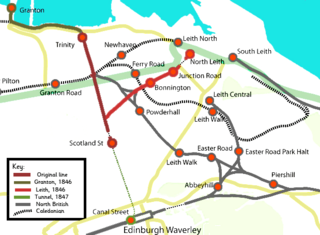
The Edinburgh, Leith and Newhaven Railway was a railway company formed in 1836 to connect the city of Edinburgh with the harbours on the Firth of Forth. When the line connected to Granton, the company name was changed to the Edinburgh, Leith and Granton Railway. It opened part of its route in 1846, but reaching the centre of Edinburgh involved the difficult construction of a long tunnel; this was opened in 1847. It was on a steep incline and was worked by rope haulage.

<span class="mw-page-title-main">Thomas Grainger</span> Scottish civil engineer and surveyor

Thomas Grainger FRSE was a Scottish civil engineer and surveyor. He was joint partner with John Miller in the prominent engineering firm of Grainger & Miller.

<span class="mw-page-title-main">Edinburgh Gateway station</span> Railway station in Edinburgh, Scotland

Edinburgh Gateway station is a railway station and interchange at Gogar in Edinburgh, Scotland, which opened on 11 December 2016. It is served by ScotRail and Edinburgh Trams, and serves both Gogar and Edinburgh Airport, to which it is connected by the tram line.

<span class="mw-page-title-main">Craiglockhart railway station</span> Former railway station in Scotland

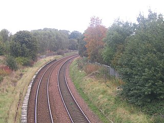
Craiglockhart Railway Station was a railway station in Scotland on the Edinburgh Suburban and Southside Junction Railway (SSJR). It was opened on 1 June 1887. Located on Colinton Road next to the Myreside Aqueduct of the Union Canal, it served the Craiglockhart area of Edinburgh, in the south-west of the city.

<span class="mw-page-title-main">Blackford Hill railway station</span> Disused railway station in Newington, Edinburgh

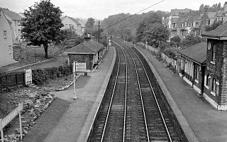
Blackford Hill railway station was a railway station in the Blackford area of Edinburgh, Scotland. It was located at the foot of Blackford Hill on the Edinburgh Suburban and Southside Junction Railway (ESSJR). It was opened on 1 December 1884.

<span class="mw-page-title-main">Duddingston & Craigmillar railway station</span> Former railway station in Scotland

Duddingston & Craigmillar Railway Station was a railway station in Scotland on the Edinburgh Suburban and Southside Junction Railway. It served the Duddingston and Craigmillar areas of Edinburgh's south side. It was opened on 1 December 1884.

<span class="mw-page-title-main">CAF Urbos 3 (Edinburgh)</span> Type of the CAF Urbos 3 Tram operating on the Edinburgh Tram network

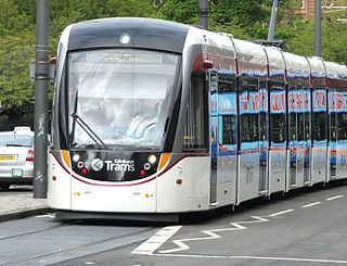
The Edinburgh Tram network operates a fleet of CAF Urbos 3 low-floor trams that were specially designed for use in the city. Twenty-seven were built in Beasain, Spain, between 2009 and 2011.

The Caledonian Railway lines to Edinburgh started with the main line that reached Edinburgh in 1848 as part of its route connecting the city with Glasgow and Carlisle. The potential of the docks at Granton and Leith led to branch line extensions, and residential development encouraged branch lines in what became the suburbs of Edinburgh. In 1869 a line was opened from Carfin through Shotts giving the Caledonian a shorter route between Glasgow and Edinburgh.

References

  1. "Scottish Light Rail : is it a "U" Turn?". Light Rail Transit Association. Archived from the original on 27 June 2009. Retrieved 13 January 2010.
  2. "Tram Facts 8" (PDF). 2006. Archived from the original (PDF) on 6 October 2011.
  3. "Edinburgh Tram (Line One) Bill Environmental Statement" (PDF). City of Edinburgh Council/ Scottish Parliament. Archived from the original (PDF) on 23 April 2010. Retrieved 14 January 2010.
  4. "Funding concerns for tram project". BBC News. 24 April 2009. Retrieved 11 January 2010.
  5. 1 2 "Edinburgh Tram (Line Two) Bill Environmental Statement" (PDF). Archived from the original (PDF) on 17 December 2009. Retrieved 15 January 2010.
  6. Stevenson, Stewart (27 September 2007). "Edinburgh Airport Rail Link". Scottish Parliament. Archived from the original on 4 May 2007. Retrieved 12 January 2010.
  7. "Edinburgh Tram Project Line 3 report". City of Edinburgh Council. 24 February 2004. Retrieved 15 January 2010.
  8. "Transport chiefs 'want Edinburgh tram network'". BBC News. 4 March 2010. Retrieved 4 March 2010.
  9. Ferguson, Brian (24 March 2005). "Edinburgh's third tram line is dead". Edinburgh Evening News. Retrieved 12 January 2010.
  10. Roden, Alan (23 August 2005). "Scotsman.com News". The Scotsman. Edinburgh. Retrieved 21 May 2010.
  11. "Reopening the South Sub" (PDF). Transform Scotland. March 2007. Archived from the original (PDF) on 11 August 2011. Retrieved 8 January 2010.
  12. "Public Petitions Committee Official Report". Scottish Parliament. 27 January 2009. Archived from the original on 5 June 2011. Retrieved 8 January 2010.