Provenance (geology)

Last updated

The main rock types Cycle of rocks 2.png
The main rock types

Provenance in geology, is the reconstruction of the origin of sediments. The Earth is a dynamic planet, and all rocks are subject to transition between the three main rock types: sedimentary, metamorphic, and igneous rocks (the rock cycle). Rocks exposed to the surface are sooner or later broken down into sediments. Sediments are expected to be able to provide evidence of the erosional history of their parent source rocks. The purpose of provenance study is to restore the tectonic, paleo-geographic and paleo-climatic history.

Contents

In the modern geological lexicon, "sediment provenance" specifically refers to the application of compositional analyses to determine the origin of sediments. This is often used in conjunction with the study of exhumation histories, interpretation of drainage networks and their evolution, and forward-modelling of paleo-earth systems. In combination, these help to characterise the "source to sink" journey of clastic sediments from hinterland to sedimentary basin.

Introduction

Provenance (from the French provenir, "to come from"), is the place of origin or earliest known history of something. [1] In geology (specifically, in sedimentary petrology), the term provenance deals with the question where sediments originate from. The purpose of sedimentary provenance studies is to reconstruct and to interpret the history of sediment from parent rocks at a source area to detritus at a burial place. [2] The ultimate goal of provenance studies is to investigate the characteristics of a source area by analyzing the composition and texture of sediments. [3] The studies of provenance involve the following aspects: "(1) the source(s) of the particles that make up the rocks, (2) the erosion and transport mechanisms that moved the particles from source areas to depositional sites, (3) the depositional setting and depositional processes responsible for sedimentation of the particles (the depositional environment), and (4) the physical and chemical conditions of the burial environment and diagenetic changes that occur in siliciclastic sediment during burial and uplift". [4] Provenance studies are conducted to investigate many scientific questions, for example, the growth history of continental crust, [5] [6] collision time of Indian and Asian plates, [7] Asian monsoon intensity, and Himalayan exhumation [8] Meanwhile, the provenance methods are widely used in the oil and gas industry. "Relations between provenance and basin are important for hydrocarbon exploration because sand frameworks of contrasting detrital compositions respond differently to diagenesis, and thus display different trends of porosity reduction with depth of burial." [9]

Source of detritus

All rock exposed at the Earth's surface is subjected to physical or chemical weathering and broken down into finer grained sediment. All three types of rocks (igneous, sedimentary and metamorphic rocks) can be the source of detritus.

Transportation of detritus

Distribution of detritus Distribution of detritus.png
Distribution of detritus

Rocks are transported downstream from higher elevation to lower elevation. Source rocks and detritus are transported by gravity, water, wind or glacial movement. The transportation process breaks rocks into smaller particles by physical abrasion, from big boulder size into sand or even clay size. At the same time minerals within the sediment can also be changed chemically. Only minerals that are more resistant to chemical weathering can survive (e.g. ultrastable minerals zircon, tourmaline and rutile). During the transportation, minerals can be sorted by their density, and as a result, light minerals like quartz and mica can be moved faster and further than heavy minerals (like zircon and tourmaline).

Accumulation of detritus

After a certain distance of transportation, detritus reaches a sedimentary basin and accumulates in one place. With the accumulation of sediments, sediments are buried to a deeper level and go through diagenesis, which turns separate sediments into sedimentary rocks (i.e. conglomerate, sandstone, mudrocks, limestone etc.) and some metamorphic rocks (such as quartzite) which were derived from sedimentary rocks. After sediments are weathered and eroded from mountain belts, they can be carried by stream and deposited along rivers as river sands. Detritus can also be transported and deposited in foreland basins and at offshore fans. The detrital record can be collected from all these places and can be used in provenance studies. [10] [11] [12]

Examples of detritus accumulation
Detritus TypeDepositional environmentLocationCoordinatesReference
Loess sand Loess Loess Plateau 38°24′N108°24′E / 38.4°N 108.4°E / 38.4; 108.4 [13]
Detrital apatiteContinental margin East Greenland Margin 63°30′N39°42′W / 63.5°N 39.7°W / 63.5; -39.7 [10]
Detrital zirconModern river Red River 22°34′N103°53′E / 22.56°N 103.88°E / 22.56; 103.88 [14]
Heavy mineral Accretionary complex South-central Alaska 61°00′N149°42′W / 61.00°N 149.70°W / 61.00; -149.70 [15]
Detrital zirconAncient passive continental margin Southern Lhasa terrane 29°15′N85°15′E / 29.25°N 85.25°E / 29.25; 85.25 [7]
Detrital zircon Foreland basin Nepal Himalayan foreland basin 27°52′N83°34′E / 27.86°N 83.56°E / 27.86; 83.56 [16]

Reworking of detritus

After detritus are eroded from source area, they are transported and deposited in river, foreland basin or flood plain. Then the detritus can be eroded and transported again when flooding or other kinds of eroding events occur. This process is called as reworking of detritus. And this process could be problematic to provenance studies. [17] For example, U-Pb zircon ages are generally considered to reflect the time of zircon crystallization at about 750 °C and zircon is resistant to physical abrasion and chemical weathering. So zircon grains can survive from multiple cycles of reworking. This means if the zircon grain is reworked (re-eroded) from a foreland basin (not from original mountain belt source area) it will lose information of reworking (detrital record will not indicate the foreland basin as a source area but will indicate the earlier mountain belt as a source area). To avoid this problem, samples can be collected close to the mountain front, upstream from which there is no significant sediment storage. [12]

Development of provenance methods

The study of sedimentary provenance involves several geological disciplines, including mineralogy, geochemistry, geochronology, sedimentology, igneous and metamorphic petrology. [18] The development of provenance methods are heavily dependent on the development of these mainstream geological disciplines. The earliest provenance studies were primarily based on paleocurrent analysis and petrographic analysis (composition and texture of sandstone and conglomerate). [19] Since the 1970s, provenance studies shifted to interpret tectonic settings (i.e. magmatic arcs, collision orogens and continental blocks) using sandstone composition. [9] Similarly, bulk rock geochemistry techniques are applied to interpret provenance linking geochemical signatures to source rocks and tectonic settings. Later, with the development of chemical and isotopic micro-analysis methods and geochronological techniques(e.g. ICP-MS, SHRIMP), provenance researches shifted to analyze single mineral grains. The following table has examples of where provenance study samples are collected.

Provenance methods

Generally, provenance methods can be sorted into two categories, which are petrological methods and geochemical methods. Examples of petrological methods include QFL ternary diagram, heavy mineral assemblages (apatitetourmaline index, garnet zircon index), clay mineral assemblages and illite crystallinity, reworked fossils and palynomorphs, and stock magnetic properties. Examples of geochemical methods include zircon U-Pb dating (plus Hf isotope), zircon fission track, apatite fission track, bulk sediment Nd and Sr isotopes, garnet chemistry, pyroxene chemistry, amphibole chemistry and so on. There is a more detailed list below with references to various types of provenance methods.

MethodCase studiesStrength
Zircon U–Pb dating [12] [20] [21] Determine detrital zircon age of crystallization
Zircon U–Pb plus Hf isotopes [22] [14] [23] εHf(t) > 0, Granite melts formed by the melting of young crust recently formed from depleted mantle generates zircons with radiogenic initial Hf isotopic compositions similar to that of their mantle source; εHf(t) < 0, Felsic melts derived from melting of reworked, old continental crust generates zircons with unradiogenic initial Hf isotope ratios. [24]
Apatite fission track [10] [25] [26] [27] Thermochronological age (when mineral pass closure temperature).
Zircon fission track [28] [29] Thermochronological age, crystallization age, lag time (thermochronological age minus the depositional age) [30]
Zircon He and U–Pb double dating [17] [31] [32] "This method gives both the high temperature (~900C) U–Pb crystallization and low temperature (~180C) (U–Th)/He exhumation ages for the same zircon." [17]
Bulk sediment Nd and Sr [31] [33] Nd model age, ultimate protolith or source area [34]
Bulk sediment Pb isotopes [35] Complicated Pb isotopes systematics makes it powerful tool to exam a source rock's geologic history especially in ancient heritage. [35]
Heavy mineral assemblages (apatite-tourmaline index,garnet zircon index) [36] [37] Heavy mineral assemblage of sedimentary rock is a function of the source rock type. For example,kyanite and sillimanite assemblage-rich indicates high-grade metamorphic source rocks
Garnet geochemistry [38] N/A
Ar–Ar mica dating [39] [40] Indicate time of mica cooling through Ar-Ar closure temperature due to exhumation.
Nd isotopes in apatite [41] Nd model age (reference), ultimate protolith or source area.
Pyroxene chemistry [38] [15] Variable chemistry composition Ca-Mg-Fe indicative of source magma and source rock.
Amphibole chemistry [38] [42] Major and trace element analyses of amphibole grains are used to provenance studies.
Pb isotopes in K-feldspar [43] N/A
Clay mineralogy (assemblages and illite crystallinity) [44] Original abundance of clay minerals in source determines the assemblege distribution in detrital record. The weathering and change of chemical composition also affect distribution.
Monazite U–Pb dating [11] Determine detrital monozite mineral age of crystallization.
Heavy mineral stability during diagenesisN/AN/A
Bulk sediment trace element chemistry [45] More sensitive indicators of geological processes than major elements
Rutile U-PbN/ADetermine detrital rutile mineral age of crystallization
U–Pb detrital titanite [46] Determine detrital titanite age of crystallization
Zircon REE and Th/U [47] [48] [49] Zircon grain derived from different types of granite can be discriminated by their REE ratios.
Reworked fossils and palynomorphs [50] [51] Use reworked fossil (caused by compression, heating, oxidation, microbial attack) and Palynomorphs (plant or animal structure, resistance to decay, sporopollenin chitin to find where sediment derived from.
Bulk sediment Ar–Ar [52] [53] age of a mineral or whole rock cooled below closure temperature.
Quartz equivalent series resistance(ESR) [54] [55] Use ESR intensity to correlate detrital record with source rock.
Rock magnetic properties [56] [57] Substitute or supplement geochemical provenance data, using magnetic susceptibility, hysteresis loops, theromagnetic curves and iron-oxide mineral petrography to correlate sediment with source area.

Examples of provenance methods

Sandstone composition and plate tectonics

This method is widely used in provenance studies and it has the ability to link sandstone composition to tectonic setting. This method is described in the Dickinson and Suczek 1979 paper. [9] Detrital framework modes of sandstone suites from different kinds of basins are a function of provenance types governed by plate tectonics. (1)Quartzose sands from continental cratons are widespread within interior basins, platform successions, miogeoclinal wedges, and opening ocean basins. (2)Arkosic sands from uplifted basement blocks are present locally in rift troughs and in wrench basins related to transform ruptures. (3)Volcaniclastic lithic sand and more complex volcano-plutonic sands derived from magmatic arcs are present in trenches, forearc basins and marginal seas. (4) Recycled orogenic sands, rich in quartz or chert plus other lithic fragments and derived from subduction complexes, collision orogens, and foreland uplifts, are present in closing ocean basins. Triangular diagrams showing framework proportions of quartz, the two feldspars, polycrystalline quartzose lithics, and unstable lithics of volcanic and sedimentary parentage successfully distinguish the key provenance types." [9]

Resolving provenance problems by dating detrital minerals

An example of U-Pb relative age probability diagram An example of U-Pb relative age probability diagram.png
An example of U–Pb relative age probability diagram

Geochronology and thermochronology are more and more applied to solve provenance and tectonic problems. [58] [16] [59] [60] [61] Detrital minerals used in this method include zircons, monazites, white micas and apatites. The age dated from these minerals indicate timing of crystallization and multiple tectono-thermal events. This method is based on the following considerations: "(1) the source areas are characterized by rocks with different tectonic histories recorded by distinctive crystallization and cooling ages; (2) the source rocks contain the selected mineral;" [62] (3) Detrital mineral like zircon is ultra-stable which means it is capable of surviving multiple phases of physical and chemical weathering, erosion and deposition. This property make these detrital mineral ideal to record long history of crystallization of tectonically complex source area.

The figure to the right is an example of U–Pb relative age probability diagram. [16] The upper plot shows foreland basin detrital zircon age distribution. The lower plot shows hinterland (source area) zircon age distribution. In the plots, n is the number of analyzed zircon grains. So for foreland basin Amile formation, 74 grains are analyzed. For source area (divided into 3 tectonic level, Tethyan Himalaya, Greater Himalaya and Lesser Himalaya), 962, 409 and 666 grains are analyzed respectively. To correlate hinterland and foreland data, let's see the source area record first, Tethyan sequence have age peak at ~500 Myr, 1000 Myr and 2600 Myr, Greater Himalaya has age peaks at ~1200 Myr and 2500 Myr, and Lesser Himalaya sequence has age peaks at ~1800 Ma and 2600 Ma. By simply comparing the foreland basin record with source area record, we cam see that Amile formation resemble age distribution of Lesser Himalaya. It has about 20 grains with age ~1800 Myr (Paleoproterozoic) and about 16 grains yield age of ~2600 Myr (Archean). Then we can interpret that sediments of Amile formation are mainly derived from the Lesser Himalaya, and rocks yield ago of Paleoproterozoic and Archean are from the Indian craton. So the story is: Indian plate collide with Tibet, rocks of Indian craton deformed and involved into Himalayan thrust belt (e.g. Lesser Himalaya sequence), then eroded and deposited at foreland basin.

U–Pb geochronology of zircons was conducted by laser ablation multicollector inductively coupled plasma mass spectrometry (LA-MC-ICPMS).

Bulk sediment Nd and Sr

An example of Nd and Sr isotopic data plots which are used in provenance studies Sm-Nd plot.png
An example of Nd and Sr isotopic data plots which are used in provenance studies

Depend on properties of Sm–Nd radioactive isotope system can provide age estimation of sedimentary source rocks. It has been used in provenance studies. [31] [33] [63] [64] 143Nd is produced by α decay of 147Sm and has a half life of 1.06×10¹¹ years. Variation of 143Nd/144Nd is caused by decay of 147Sm. Now Sm/Nd ratio of the mantle is higher than that of the crust and 143Nd/144Nd ratio is also higher than in the mantle than in the crust. 143Nd/144Nd ratio is expressed in εNd notation (DePaolo and Wasserbur 1976). [64] . CHUR refer to Chondritic Uniform Reservoir. So ϵNd is a function of T (time). Nd isotope evolution in mantle and crust in shown in the figure to the right. The upper plot (a), bold line shows the evolution of the bulk earth or CHUR(chondritic uniform reservoir). The lower plot (b) shows evolution of bulk earth (CHUR) crust and mantle, 143Nd/144Nd is transformed to εNd. [65] Normally, the most rocks have εNd values in the range of -20 to +10. Calculated εNd value of rocks can be correlated to source rocks to perform provenance studies. In addition, Sr and Nd isotopes have been used to study both provenance and weathering intensity. [33] Nd is mainly unaffected by weathering process but 87Sr/86Sr value is more affected by chemical weathering. [66] [67]

Lab data acquisition and instruments

Sensitive High Resolution Ion Microprobe (SHRIMP II) at Curtin University, Western Australia SHRIP II.JPG
Sensitive High Resolution Ion Microprobe (SHRIMP II) at Curtin University, Western Australia

To pick suitable lab data acquisition to sediment provenance, grain size should be taken into consideration. For conglomerates and boulders, as original mineral paragenesis is preserved, almost all analytical methods can be used to study the provenance. [68] For finer grained sediments, as they always lose paragenetic information, only a limited range of analytical methods can be used.

Lab data acquisition approaches for provenance study fall into the following three categories: (1) analyzing bulk composition to extract petrographic, mineralogical and chemical information. (2) analyzing specific groups of minerals such as heavy minerals and (3) analyzing single mineral grains about morphological, chemical and isotopic properties.

For bulk composition analysis, samples are crushed, powdered and disintegrated or melted. Then measurement of major and trace and rare-earth (REE) elements are conducted by using instruments like atomic absorption spectroscopy (AAS), X-ray fluorescence(XRF), neutron activation analysis (NAA) etc.

Sand-sized sediments are able to be analyzed by single-grain methods. Single-grain methods can be divided into the following three groups: (1) Microscopic-morphological techniques, which are used to observe shape, color and internal structures in minerals. For example, scanning electron microscope (SEM) and cathodoluminescence (CL) detector. [69] [70] (2) Single grain geochemical techniques, which are used to acquire chemical composition and variations within minerals. For example, laser-ablation inductively coupled plasma mass spectrometry (ICP-MS). [71] (3) Radiometric dating of single grain mineral, which can determine the geochronological and thermochronological properties of minerals. For example, U/Pb SHRIMP dating and 40Ar/39Ar laser-probe dating. [72]

Problems and limitations of provenance studies

Main steps (middle), modification processes (right) and controlling factors (left) of sediment evolution. Source to basin.png
Main steps (middle), modification processes (right) and controlling factors (left) of sediment evolution.

During the pathway of detritus transported from source area to basin, the detritus is subject to weathering, transporting, mixing, deposition, diagenesis and recycling. The complicated process can modify parents lithology both compositionally and textually. All these factors pose certain limits on our capability to restore the characteristics of source rocks from the properties of the produced detrital record. The following paragraphs briefly introduce major problems and limitations of provenance studies. [73]

Candidate source area

To correlate sediments (detrital record) to source area, several possible source area need to be chosen for comparison. In this process, possible source area where sediment is from may be missed and not chosen as a candidate source area. This could cause misinterpretation in correlation sediment to source later.

Grain size

Grain size could cause misinterpretation of provenance studies. During transportation and deposition, detritus is subject to mechanical breakdown, chemical alternation and sorting. This always results in a preferential enrichment of specific materials in a certain range of grain-size, and sediment composition tends to be a function of grain size. For instance, SiO2/Al2O3 ratios decrease with decreasing of grain size because Al-rich phyllosilicate enriches at the expense of Si-rich phase in fine-grained detritus. This means the changing of composition of detrital record could reflect effect of sorting of grain size and not only changing of provenance. [74] To minimize the influence of sedimentary sorting on provenance method (like Sr-Nd isotopic method), only very fine-grained to fine-grained sandstones are collected as samples but medium-grained sandstones can be used when alternatives are unavailable. [75]

Mixing of detritus

Mixing of detritus from multiple sources may cause problems with correlating the final detrital record to source rocks, especially when dispersal pathways are complex and involve recycling of previously deposited sediments. For example, if a detrital record contains zircon grains with an age of one billion years that were transported by rivers flowing through two source areas containing zircons which are also one billion years old, it would not be possible to determine which of the two upstream source areas was the source of the zircon detritus, based on age alone.

Diagenesis

Diagenesis could be a problem when analyzing detrital records especially when dealing with ancient sediments which are always lithified. [76] Variation of clay minerals in detrital record may not reflect variation of provenance rock, but burial effect. For example, clay minerals become unstable at great depth, kaolinite and smectite become illte. If there is a downward increasing trend of illite components in a drilling core, we can not conclude that early detrital record indicate more illite-yield source rock but possibly as a result of burial and alternation of minerals [76]

Hinterland structural assumption

Structural assumption influence on provenance interpretation, left two cross sections are two hinterland structural assumptions and the right column is a foreland basin stratigraphy which shows variations of detrital record. Ma = Million year Structural assumption.png
Structural assumption influence on provenance interpretation, left two cross sections are two hinterland structural assumptions and the right column is a foreland basin stratigraphy which shows variations of detrital record. Ma = Million year

As a provenance study tries to correlate detrital record (which is stored in basins) to hinterland stratigraphy, and hinterland stratigraphy is structurally controlled by fault systems, so hinterland structural setting is important to interpretation of the detrital record. Hinterland structural setting is estimated by field mapping work. Geologists work along river valleys and traverse mountain belts (thrust belt), locate major faults and describe major stratigraphy bounded by faults in the area. A geologic map is the product of field mapping work, and cross sections can be constructed by interpreting a geologic map. However, a lot of assumptions are made during this process, so the hinterland structural settings are always assumptions. And these assumptions can affect interpretation of detrital record. Here is an example, the right figure shows a classic thrust belt and foreland basin system, the thrust fault carries overlying rocks to the surface and rocks of various lithology are eroded and transported to deposit at the foreland basin. In structural assumption 1, the pink layer is assumed to exist above thrust 2 and thrust 3, but in the 2nd assumption, the pink layer is only carried by thrust 2. Detrital records are stored in foreland basin stratigraphy. Within the stratigraphy, the pink layer is correlated to the hinterland pink layer. If we use structural assumption 2, we can interpret that thrust 2 was active about 12 and 5 million years ago. But when using the other assumption, we couldn't know if the pink layer record indicates activity of thrust 2 or 3.

Sediment provenance studies in hydrocarbon exploration and production

A combination usage of multiple provenance methods (e.g.petrography, heavy mineral analysis, mineral geochemistry, wholerock geochemistry, geochronology and drainage capture analysis)can provide valuable insights to all stages of hydrocarbon exploration and production. [77] [78] In exploration stage, provenance studies can enhance the understanding of reservoir distribution and reservoir quality. These will affect chance of success of exploration project; In development stage, mineralogical and chemical techniques are widely used to estimate reservoir zonation and correlation of stratigraphy. [79] At the same time, these provenance techniques are also used in production stage. For example, they are used to assess permeability variations and well decline rate resulting from spatial variability in diagenesis and depositional facies [77]

See also

Related Research Articles

<span class="mw-page-title-main">Sedimentary rock</span> Rock formed by the deposition and cementation of particles

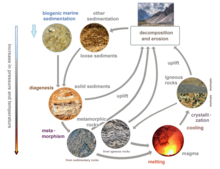
Sedimentary rocks are types of rock that are formed by the accumulation or deposition of mineral or organic particles at Earth's surface, followed by cementation. Sedimentation is the collective name for processes that cause these particles to settle in place. The particles that form a sedimentary rock are called sediment, and may be composed of geological detritus (minerals) or biological detritus. The geological detritus originated from weathering and erosion of existing rocks, or from the solidification of molten lava blobs erupted by volcanoes. The geological detritus is transported to the place of deposition by water, wind, ice or mass movement, which are called agents of denudation. Biological detritus was formed by bodies and parts of dead aquatic organisms, as well as their fecal mass, suspended in water and slowly piling up on the floor of water bodies. Sedimentation may also occur as dissolved minerals precipitate from water solution.

<span class="mw-page-title-main">Zircon</span> Zirconium silicate, a mineral belonging to the group of nesosilicates

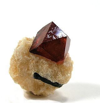
Zircon is a mineral belonging to the group of nesosilicates and is a source of the metal zirconium. Its chemical name is zirconium(IV) silicate, and its corresponding chemical formula is ZrSiO4. An empirical formula showing some of the range of substitution in zircon is (Zr1–y, REEy)(SiO4)1–x(OH)4x–y. Zircon precipitates from silicate melts and has relatively high concentrations of high field strength incompatible elements. For example, hafnium is almost always present in quantities ranging from 1 to 4%. The crystal structure of zircon is tetragonal crystal system. The natural color of zircon varies between colorless, yellow-golden, red, brown, blue, and green.

<span class="mw-page-title-main">Wilcox Group</span> Geologic group in North America

The Wilcox Group is an important geologic group in the Gulf of Mexico Basin and surrounding onshore areas from Mexico and Texas to Louisiana and Alabama. The group ranges in age from Paleocene to Eocene and is in Texas subdivided into the Calvert Bluff, Simsboro and Hooper Formations, and in Alabama into the Nanafalia and Hatchetigbee Formations. Other subdivisions are the Lower, Middle and Upper Wilcox Subgroups, and the Carrizo and Indio Formations.

<span class="mw-page-title-main">Fission track dating</span> Radiometric dating technique

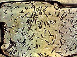
Fission track dating is a radiometric dating technique based on analyses of the damage trails, or tracks, left by fission fragments in certain uranium-bearing minerals and glasses. Fission-track dating is a relatively simple method of radiometric dating that has made a significant impact on understanding the thermal history of continental crust, the timing of volcanic events, and the source and age of different archeological artifacts. The method involves using the number of fission events produced from the spontaneous decay of uranium-238 in common accessory minerals to date the time of rock cooling below closure temperature. Fission tracks are sensitive to heat, and therefore the technique is useful at unraveling the thermal evolution of rocks and minerals. Most current research using fission tracks is aimed at: a) understanding the evolution of mountain belts; b) determining the source or provenance of sediments; c) studying the thermal evolution of basins; d) determining the age of poorly dated strata; and e) dating and provenance determination of archeological artifacts.

<span class="mw-page-title-main">Geology of Nepal</span>

The geology of Nepal is dominated by the Himalaya, the highest, youngest and a very highly active mountain range. Himalaya is a type locality for the study of on-going continent-continent collision tectonics. The Himalayan arc extends about 2,400 km (1,500 mi) from Nanga Parbat by the Indus River in northern Pakistan eastward to Namche Barwa by the gorge of the Tsangpo-Brahmaputra in eastern Tibet. About 800 km (500 mi) of this extent is in Nepal; the remainder includes Bhutan and parts of Pakistan, India, and China.

<span class="mw-page-title-main">Main Central Thrust</span>

The Main Central Thrust is a major geological fault where the Indian Plate has pushed under the Eurasian Plate along the Himalaya. The fault slopes down to the north and is exposed on the surface in a NW-SE direction (strike). It is a thrust fault that continues along 2900 km of the Himalaya mountain belt.

<span class="mw-page-title-main">Himalayan foreland basin</span> Active collisional foreland basin in South Asia

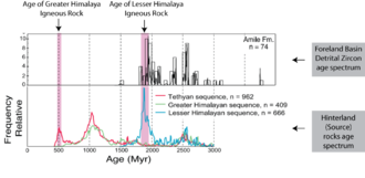
The Himalayan foreland basin is an active collisional foreland basin system in South Asia. Uplift and loading of the Eurasian Plate on to the Indian Plate resulted in the flexure (bending) of the Indian Plate, and the creation of a depression adjacent to the Himalayan mountain belt. This depression was filled with sediment eroded from the Himalaya, that lithified and produced a sedimentary basin ~3 to >7 km deep. The foreland basin spans approximately 2,000 kilometres (1,200 mi) in length and 450 kilometres (280 mi) in width. From west to east the foreland basin stretches across five countries: Pakistan, India, Nepal, Bangladesh, and Bhutan.

<span class="mw-page-title-main">Lhasa terrane</span> Fragment of crustal material that forms present-day southern Tibet

The Lhasa terrane is a terrane, or fragment of crustal material, sutured to the Eurasian Plate during the Cretaceous that forms present-day southern Tibet. It takes its name from the city of Lhasa in the Tibet Autonomous Region, China. The northern part may have originated in the East African Orogeny, while the southern part appears to have once been part of Australia. The two parts joined, were later attached to Asia, and then were impacted by the collision of the Indian Plate that formed the Himalayas.

<span class="mw-page-title-main">Pre-collisional Himalaya</span>

Pre-collisional Himalaya is the arrangement of the Himalayan rock units before mountain-building processes resulted in the collision of Asia and India. The collision began in the Cenozoic and it is a type locality of a continental-continental collision. The reconstruction of the initial configuration of the rock units and the relationship between them is highly controversial, and major concerns relate to the arrangements of the different rock units in three dimensions. Several models have been advanced to explain the possible arrangements and petrogenesis of the rock units.

<span class="mw-page-title-main">Detrital zircon geochronology</span> Science of analyzing the age of zircons

Detrital zircon geochronology is the science of analyzing the age of zircons deposited within a specific sedimentary unit by examining their inherent radioisotopes, most commonly the uranium–lead ratio. Zircon is a common accessory or trace mineral constituent of most granite and felsic igneous rocks. Due to its hardness, durability and chemical inertness, zircon persists in sedimentary deposits and is a common constituent of most sands. Zircons contain trace amounts of uranium and thorium and can be dated using several modern analytical techniques.

<span class="mw-page-title-main">Huangling Anticline</span>

The Huangling Anticline or Complex represents a group of rock units that appear in the middle of the Yangtze Block in South China, distributed across Yixingshan, Zigui, Huangling, and Yichang counties. The group of rock involves nonconformity that sedimentary rocks overlie the metamorphic basement. It is a 73-km long, asymmetrical dome-shaped anticline with axial plane orientating in the north-south direction. It has a steeper west flank and a gentler east flank. Basically, there are three tectonic units from the anticline core to the rim, including Archean to Paleoproterozoic metamorphic basement, Neoproterozoic to Jurassic sedimentary rocks, and Cretaceous fluvial deposit sedimentary cover. The northern part of the core is mainly tonalite-trondhjemite-gneiss (TTG) and Cretaceous sedimentary rock called the Archean Kongling Complex. The middle of the core is mainly the Neoproterozoic granitoid. The southern part of the core is the Neoproterozoic potassium granite. Two basins are situated on the western and eastern flanks of the core, respectively, including the Zigui basin and Dangyang basin. Both basins are synforms while Zigui basin has a larger extent of folding. Yuanan Graben and Jingmen Graben are found within the Dangyang Basin area. The Huangling Anticline is an important area that helps unravel the tectonic history of the South China Craton because it has well-exposed layers of rock units from Archean basement rock to Cretaceous sedimentary rock cover due to the erosion of the anticline.

<span class="mw-page-title-main">Geology of Hainan Island</span>

Hainan Island, located in the South China Sea off the Chinese coast and separated from mainland China by the Qiongzhou Strait, has a complex geological history that it has experienced multiple stages of metamorphism, volcanic and intrusive activities, tectonic drifting and more. The oldest rocks, the Proterozoic metamorphic basement, are not widely exposed, but mostly found in the western part of the Island.

<span class="mw-page-title-main">Hadean zircon</span> Oldest-surviving crustal material from the Earths earliest geological time period

Hadean zircon is the oldest-surviving crustal material from the Earth's earliest geological time period, the Hadean eon, about 4 billion years ago. Zircon is a mineral that is commonly used for radiometric dating because it is highly resistant to chemical changes and appears in the form of small crystals or grains in most igneous and metamorphic host rocks.

<span class="mw-page-title-main">Archean felsic volcanic rocks</span> Felsic volcanic rocks formed in the Archean Eon

Archean felsic volcanic rocks are felsic volcanic rocks that were formed in the Archean Eon. The term "felsic" means that the rocks have silica content of 62–78%. Given that the Earth formed at ~4.5 billion year ago, Archean felsic volcanic rocks provide clues on the Earth's first volcanic activities on the Earth's surface started 500 million years after the Earth's formation.

The geology of Argentina includes ancient Precambrian basement rock affected by the Grenville orogeny, sediment filled basins from the Mesozoic and Cenozoic as well as newly uplifted areas in the Andes.

<span class="mw-page-title-main">South China Craton</span> Precambrian continental block located in China

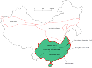
The South China Craton or South China Block is one of the Precambrian continental blocks in China. It is traditionally divided into the Yangtze Block in the NW and the Cathaysia Block in the SE. The Jiangshan–Shaoxing Fault represents the suture boundary between the two sub-blocks. Recent study suggests that the South China Block possibly has one more sub-block which is named the Tolo Terrane. The oldest rocks in the South China Block occur within the Kongling Complex, which yields zircon U–Pb ages of 3.3–2.9 Ga.

<span class="mw-page-title-main">Mazatzal orogeny</span> Mountain-building event in North America

The Mazatzal orogeny was an orogenic event in what is now the Southwestern United States from 1650 to 1600 Mya in the Statherian Period of the Paleoproterozoic. Preserved in the rocks of New Mexico and Arizona, it is interpreted as the collision of the 1700-1600 Mya age Mazatzal island arc terrane with the proto-North American continent. This was the second in a series of orogenies within a long-lived convergent boundary along southern Laurentia that ended with the ca. 1200–1000 Mya Grenville orogeny during the final assembly of the supercontinent Rodinia, which ended an 800-million-year episode of convergent boundary tectonism.

<span class="mw-page-title-main">Picuris orogeny</span> Mountain-building event in what is now the Southwestern US

The Picuris orogeny was an orogenic event in what is now the Southwestern United States from 1.43 to 1.3 billion years ago in the Calymmian Period of the Mesoproterozoic. The event is named for the Picuris Mountains in northern New Mexico and interpreted either as the suturing of the Granite-Rhyolite crustal province to the southern margin of the proto-North American continent Laurentia or as the final suturing of the Mazatzal crustal province onto Laurentia. According to the former hypothesis, this was the second in a series of orogenies within a long-lived convergent boundary along southern Laurentia that ended with the ca. 1200–1000 Mya Grenville orogeny during the final assembly of the supercontinent Rodinia, which ended an 800-million-year episode of convergent boundary tectonism.

California River is the name of a northeastward flowing river system that existed in the Cretaceous-Eocene in the western United States. It is so named because it flowed from the Mojave region of California to the Uinta Basin of Utah, transporting sediments along this track towards Lake Uinta.

Sidney Hemming is an analytical geochemist known for her work documenting Earth's history through analysis of sediments and sedimentary rocks. She is a professor of earth and environmental sciences at Columbia University.

References

  1. Oxford English Dictionary. Oxford University Press. 1939.
  2. Weltje, G.J. and von Eynatten, H. (2004). "Quantitative provenance analysis of sediments: review and outlook". Sedimentary Geology. 171 (1–4): 1–11. Bibcode:2004SedG..171....1W. doi:10.1016/j.sedgeo.2004.05.007.{{cite journal}}: CS1 maint: multiple names: authors list (link)
  3. Pettijohn, F.J.; et al. Sand and sandstone. Springer. p. 553.
  4. Boggs, Sam (1992). Petrology of sedimentary Rocks.
  5. Taylor and McLennan (1995). "The Geochemical Evolution of the continental crust". Reviews of Geophysics. 33 (2): 241. Bibcode:1995RvGeo..33..241T. doi:10.1029/95rg00262.
  6. McLennan, S. M.; et al. (1993). "Geochemical approaches to sedimentation, provenance, and tectonics". In Mark J. Johnsson; Abhijit Basu (eds.). Processes Controlling the Composition of Clastic Sediments. Geological Society of America Special Papers. Vol. 284. pp. 21–40. doi:10.1130/spe284-p21. ISBN   0-8137-2284-5.
  7. 1 2 3 DeCelles P.G.; et al. (2014). "Paleocene-Eocene foreland basin evolution in the Himalaya of southern Tibet and Nepal: Implications for the age of initial India-Asia collision". Tectonics. 33 (5): 824–849. Bibcode:2014Tecto..33..824D. doi: 10.1002/2014tc003522 . S2CID   55179413.
  8. Clift P. D.; et al. (2008). "Correlation of Himalayan exhumation rates and Asian monsoon intensity". Nature Geoscience. 1 (12): 875–880. Bibcode:2008NatGe...1..875C. doi:10.1038/ngeo351. hdl: 1885/29309 .
  9. 1 2 3 4 Dickinson, W. R.; Suczek, C. A. (1 December 1979). "Plate Tectonics and Sandstone Compositions". AAPG Bulletin. 63 (12): 2164–2182. doi:10.1306/2f9188fb-16ce-11d7-8645000102c1865d.
  10. 1 2 3 Clift, P. D.; et al. (1996). "Constraints on the evolution of the East Greenland margin; evidence from detrital apatite in offshore sediments". Geology. 24 (11): 1013–1016. Bibcode:1996Geo....24.1013C. doi:10.1130/0091-7613(1996)024<1013:coteot>2.3.co;2.
  11. 1 2 White, N. M.; et al. (2001). "Metamorphism and exhumation of the NW Himalaya constrained by U-Th-Pb analyses of detrital monazite grains from early foreland basin sediments". Journal of the Geological Society of London. 158 (4): 625–635. Bibcode:2001JGSoc.158..625W. doi:10.1144/jgs.158.4.625. S2CID   18307102.
  12. 1 2 3 Alizai,A.; et al. (2011). "Sediment provenance, reworking and transport processes in the Indus River by U–Pb dating of detrital zircon grains". Global and Planetary Change. 76 (1–2): 33–55. Bibcode:2011GPC....76...33A. doi:10.1016/j.gloplacha.2010.11.008.
  13. Sun, J. (2002). "Provenance of loess material and formation of loess deposits on the Chinese Loess Plateau". Earth and Planetary Science Letters. 203 (3–4): 845–859. Bibcode:2002E&PSL.203..845S. doi:10.1016/s0012-821x(02)00921-4.
  14. 1 2 Hoang, L. V.; et al. (2009). "Evaluating the evolution of the Red River system based on in-situ U–Pb dating and Hf isotope analysis of zircons". Geochemistry, Geophysics, Geosystems. 10 (11): n/a. Bibcode:2009GGG....1011008V. doi: 10.1029/2009gc002819 .
  15. 1 2 Clift, P. D.; et al. (2012). "Evolving heavy mineral assemblages reveal changing exhumation and trench tectonics in the Mesozoic Chugach accretionary complex, South-Central Alaska". Geological Society of America Bulletin. 124 (5–6): 989–1006. Bibcode:2012GSAB..124..989C. doi:10.1130/b30594.1.
  16. 1 2 3 DeCelles; et al. (2004). "Detrital geochronology and geochemistry of Cretaceous—Early Miocene strata of Nepal: Implications for timing and diachroneity of initial Himalayan orogenesis". Earth and Planetary Science Letters. 277 (3–4): 313–330. Bibcode:2004E&PSL.227..313D. doi:10.1016/j.epsl.2004.08.019.
  17. 1 2 3 Campbell, I. H.; et al. (2005). "He-Pb double dating of detrital zircons from the Ganges and Indus rivers; implication for quantifying sediment recycling and provenance studies". Earth Planet. Sci. Lett. 237 (3–4): 402–432. Bibcode:2005E&PSL.237..402C. doi:10.1016/j.epsl.2005.06.043.
  18. Haughton and Morton (1991). "Sedimentary provenance studies". In Morton, A.C.; Todd, S.P.; Haughton, P.D.W. (eds.). Developments in Sedimentary Provenance Studies.
  19. Krumberin and Sloss (1963). Stratigraphy and Sedimentology (2nd ed.). W.H.Freeman and Co.
  20. DeCelles, P.; et al. (2014). "Paleocene-Eocene foreland basin evolution in the Himalaya of southern Tibet and Nepal: Implications for the age of initial India–Asia collision". Tectonics. 33 (5): 824–849. Bibcode:2014Tecto..33..824D. doi: 10.1002/2014tc003522 . S2CID   55179413.
  21. Amato J.M.; Pavlis T.L. (2010). "Detrital zircon ages from the Chugach Terrane, southern Alaska, reveal multiple episodes of accretion and erosion in a subduction complex". Geology. 38 (5): 462. Bibcode:2010Geo....38..459A. doi:10.1130/g30719.1.
  22. Clements,B.; et al. (2012). "Detrital zircon U-Pb age and Hf-isotope perspective on sediment provenance and tectonic models in SE Asia, in Rasbury, E. T., Hemming, S. R., and Riggs, N. R., eds". Mineralogical and Geochemical Approaches to Provenance. Geological Society of America Special Papers. 487: 37–61. doi:10.1130/2012.2487(03). ISBN   978-0-8137-2487-4.
  23. Wu, F.; et al. (2014). "Zircon U-Pb and Hf isotopic constraints on the onset time of India–Asia collision". American Journal of Science. 314 (2): 548–579. Bibcode:2014AmJS..314..548W. doi: 10.2475/02.2014.04 . S2CID   130337662.
  24. Bouvier, A.; et al. (2008). "The Lu-Hf and Sm-Nd isotopic composition of CHUR: Constraints from unequilibrated chondrites and implications for the bulk composition of terrestrial planets". Earth and Planetary Science Letters. 273 (1–2): 48–57. Bibcode:2008E&PSL.273...48B. doi:10.1016/j.epsl.2008.06.010.
  25. Resentini, A., and Malusa, M. G. (2012). "Sediment budgets by detrital apatite fissiontrack dating (Rivers Dora Baltea and Arc, Western Alps), in Rasbury, E. T., Hemming, S. R., and Riggs, N. R., eds". Mineralogical and Geochemical Approaches to Provenance. doi:10.1130/2012.2487(08).{{cite journal}}: CS1 maint: multiple names: authors list (link)
  26. Emmel, B.; et al. (2006). "Detrital apatite fission-track ages in Middle Jurassic strata at the rifted margin of W Madagascar; indicator for a protracted resedimentation history". Sedimentary Geology. 186 (1–2): 27–38. Bibcode:2006SedG..186...27E. doi:10.1016/j.sedgeo.2005.09.022.
  27. van der Beek, P.; et al. (2006). "Late Miocene-Recent exhumation of the central Himalaya and recycling in the foreland basin assessed by apatite fission-track thermochronology of Siwalik sediments, Nepal". Basin Research. 18 (4): 413–434. Bibcode:2006BasR...18..413V. doi:10.1111/j.1365-2117.2006.00305.x. S2CID   10446424.
  28. Hurford, A. J.; et al. (1991). "The role of fission track dating in discrimination of provenance, in Morton, A. C., Todd, S. P., and Haughton, P. D. W., eds". Developments in Sedimentary Provenance Studies. 57.
  29. Clift, P. D.; et al. (2013). "Zircon and apatite thermochronology of the Nankai Trough accretionary prism and trench, Japan: Sediment transport in an active and collisional margin setting". Tectonics. 32 (3): 377–395. Bibcode:2013Tecto..32..377C. doi: 10.1002/tect.20033 .
  30. Bernet M.; Van der Beek, P. (2006). "Miocene to Recent exhumation of the central Himalaya determined from combined detrital zircon fission-track and U/Pb analysis of Siwalik sediments, western Nepal" (PDF). Basin Research. 18 (4): 393–412. Bibcode:2006BasR...18..393B. doi:10.1111/j.1365-2117.2006.00303.x. S2CID   20674700.
  31. 1 2 3 Goldstein, S. L.; et al. (1984). "A Sm-Nd isotopic study of atmospheric dusts and particulates from major river systems". Earth and Planetary Science Letters. 70 (2): 221–236. Bibcode:1984E&PSL..70..221G. doi:10.1016/0012-821x(84)90007-4.
  32. Limmer, D. R.; et al. (2012). "Geochemical Record of Holocene to Recent Sedimentation on the Western Indus continental shelf, Arabian Sea". Geochemistry, Geophysics, Geosystems. 13 (1): n/a. Bibcode:2012GGG....13.1008L. doi:10.1029/2011gc003845. hdl: 1912/5030 . S2CID   128365835.
  33. 1 2 3 Limmer, D. R. (2012). "Geochemical Record of Holocene to Recent Sedimentation on the Western Indus continental shelf, Arabian Sea". Geochemistry, Geophysics, Geosystems. 13 (1): n/a. Bibcode:2012GGG....13.1008L. doi:10.1029/2011gc003845. hdl: 1912/5030 . S2CID   128365835.
  34. "Geochronology III: THE SM-ND SYSTEM" (PDF). Geology 655 Isotope Geochemistry. Cornell University. 2003. Retrieved 14 March 2022.
  35. 1 2 Downing, Greg E.; Hemming, Sidney R. (2012). "Late glacial and deglacial history of ice rafting in the Labrador Sea: A perspective from radiogenic isotopes in marine sediments". Mineralogical and Geochemical Approaches to Provenance. doi:10.1130/2012.2487(07). ISBN   9780813724874.
  36. Dewey, J. F. (1999). "Petrology of Ordovician and Silurian sediments in the Western Irish Caledonides: Tracers of short-lived Ordovician continent-arc collision orogeny and the evolution of the Laurentian Appalachian-Caledonian margin, in MacNiocaill, C., and Ryan, P. D., eds". Continental Tectonics. 164 (1): 55–108. Bibcode:1999GSLSP.164...55D. doi:10.1144/gsl.sp.1999.164.01.05. S2CID   129574741.
  37. Morton, A.; et al. (2012). "High-frequency fluctuations in heavy mineral assemblages from Upper Jurassic sandstones of the Piper Formation, UK North Sea: Relationships with sea-level change and floodplain residence, in Rasbury, E. T., Hemming, S. R., and Riggs, N. R., eds". Mineralogical and Geochemical Approaches to Provenance. doi:10.1130/2012.2487(10).
  38. 1 2 3 Mange, M.; Morton, A. C. (2007). "Geochemistry of Heavy Minerals, in Mange, M., and Wright, D., eds". Heavy Minerals in Use. doi:10.1016/S0070-4571(07)58013-1.
  39. Szulc, A. G.; et al. (2006). "Tectonic evolution of the Himalaya constrained by detrital 40Ar/39Ar, Sm/Nd and petrographic data from the Siwalik foreland basin succession, SW Nepal". Basin Research. 18 (4): 375–391. Bibcode:2006BasR...18..375S. doi:10.1111/j.1365-2117.2006.00307.x. S2CID   96459129.
  40. Hoang, L. V.; et al. (2010). "Ar-Ar Muscovite dating as a constraint on sediment provenance and erosion processes in the Red and Yangtze River systems, SE Asia". Earth and Planetary Science Letters. 295 (3–4): 379–389. Bibcode:2010E&PSL.295..379V. doi:10.1016/j.epsl.2010.04.012.
  41. Foster, G. L.; Carter, A. (2007). "Insights into the patterns and locations of erosion in the Himalaya - A combined fission-track and in situ Sm-Nd isotopic study of detrital apatite". Earth and Planetary Science Letters. 257 (3–4): 407–418. Bibcode:2007E&PSL.257..407F. doi:10.1016/j.epsl.2007.02.044.
  42. Lee, J. I.; et al. (2003). "Sediment flux in the modern Indus River inferred from the trace element composition of detrital amphibole grains". Sedimentary Geology. 160 (1–3): 243–257. Bibcode:2003SedG..160..243L. doi:10.1016/s0037-0738(02)00378-0.
  43. Gwiazda, R. H.; et al. (1996). "Tracking the sources of icebergs with lead isotopes; the provenance of ice-rafted debris in Heinrich layer 2". Paleoceanography. 11 (1): 79–93. Bibcode:1996PalOc..11...77G. doi:10.1029/95pa03135.
  44. Liu, Z.; et al. (2010). "Clay mineral distribution in surface sediments of the northeastern South China Sea and surrounding fluvial drainage basins: Source and transport". Marine Geology. 277 (1–4): 48–60. Bibcode:2010MGeol.277...48L. doi:10.1016/j.margeo.2010.08.010.
  45. Preston, J. (1998). "Integrated whole-rock trace element geochemistry and heavy mineral chemistry studies; aids to the correlation of continental red-bed reservoirs in the Beryl Field, UK North Sea". Petroleum Geoscience. 4 (1): 7–16. Bibcode:1998PetGe...4....7P. doi:10.1144/petgeo.4.1.7. S2CID   129462713.
  46. McAteer, C.A.; et al. (2010). "Detrital zircon, detrital titanite and igneous clast U–Pb geochronology and basement–cover relationships of the Colonsay Group, SW Scotland: Laurentian provenance and correlation with the Neoproterozoic Dalradian Supergroup". Precambrian Research. 181 (1–4): 21–42. Bibcode:2010PreR..181...21M. doi:10.1016/j.precamres.2010.05.013.
  47. Hoskin, P. W. O.; Ireland, T. R. (2000). "Rare earth element chemistry of zircon and its use as a provenance indicator". Geology. 28 (7): 627–630. Bibcode:2000Geo....28..627H. doi:10.1130/0091-7613(2000)28<627:reecoz>2.0.co;2.
  48. Weber, M.; et al. (2010). "U/Pb detrital zircon provenance from late cretaceous metamorphic units of the Guajira Peninsula, Colombia: Tectonic implications on the collision between the Caribbean arc and the South American margin". Journal of South American Earth Sciences. 29 (4): 805–816. Bibcode:2010JSAES..29..805W. doi:10.1016/j.jsames.2009.10.004.
  49. Nardi, L. V. S.; et al. (2013). "Zircon/rock partition coefficients of REEs, Y, Th, U, Nb, and Ta in granitic rocks: Uses for provenance and mineral exploration purposes". Chemical Geology. 335: 1–7. Bibcode:2013ChGeo.335....1N. doi:10.1016/j.chemgeo.2012.10.043.
  50. Batten, D. J. (1991). "Reworking of plant microfossils and sedimentary provenance, in Morton, A. C., Todd, S. P., and Haughton, P. D. W., eds., Developments in Sedimentary Provenance Studies". Geological Society, London, Special Publications. 57: 79–90. doi:10.1144/gsl.sp.1991.057.01.08. S2CID   129553591.
  51. Spiegler, D. (1989). "ice-rafted Cretaceous and Tertiary fossils in Pleistocene-Pliocene sediments, ODP Leg 104, Norwegian Sea" (PDF). Proc. ODP, Sci Res. Proceedings of the Ocean Drilling Program. 104: 739–744. doi: 10.2973/odp.proc.sr.104.197.1989 .
  52. VanLaningham, S.; et al. (2006). "Erosion by rivers and transport pathways in the ocean: A provenance tool using 40Ar-39Ar incremental heating on fine-grained sediment". Journal of Geophysical Research. 111 (F4): F04014. Bibcode:2006JGRF..111.4014V. doi: 10.1029/2006jf000583 .
  53. VanLaningham, S.; et al. (2009). "Glacial-interglacial sediment transport to the Meiji Drift, Northwest Pacific Ocean: evidence for timing of Beringian outwashing". Earth and Planetary Science Letters. 277 (1–2): 64–72. Bibcode:2009E&PSL.277...64V. doi:10.1016/j.epsl.2008.09.033.
  54. Sun, Y.; et al. (2013). "ESR signal intensity and crystallinity of quartz from Gobi and sandy deserts in East Asia and implication for tracing Asian dust provenance". Geochemistry, Geophysics, Geosystems. 14 (8): 2615–2627. Bibcode:2013GGG....14.2615S. doi: 10.1002/ggge.20162 . S2CID   130949895.
  55. Shimada, A.; et al. (2013). "Characteristics of ESR signals and TLCLs of quartz included in various source rocks and sediments in Japan : a clue to sediment provenance". Geochronometria. 40 (4): 334–340. Bibcode:2013Gchrm..40..334S. doi: 10.2478/s13386-013-0111-z .
  56. Hatfield, R.G.; et al. (2013). "Source as a controlling factor on the quality and interpretation of sediment magnetic records from the northern North Atlantic". Earth Planet. Sci. Lett. 368: 69–77. Bibcode:2013E&PSL.368...69H. doi:10.1016/j.epsl.2013.03.001.
  57. Brachfeld, S.; et al. (2013). "ron oxide tracers of ice sheet extent and sediment provenance in the ANDRILL AND-1B drill core, Ross Sea, Antarctica". Global and Planetary Change. 110: 420–433. Bibcode:2013GPC...110..420B. doi:10.1016/j.gloplacha.2013.09.015.
  58. White, N.M.; et al. (2002). "Constraints on the exhumation and erosion of the High Himalayan Slab, NW India, from foreland basin deposits". Earth and Planetary Science Letters. 195 (1–2): 29–44. Bibcode:2002E&PSL.195...29W. doi:10.1016/s0012-821x(01)00565-9.
  59. Dickinson, W.R.; Gehrels, G.E. (2008). "Sediment delivery to the Cordilleran foreland basin: Insights from U-Pb ages of detrital zircons in Upper Jurassic and Cretaceous strata of the Colorado Plateau". American Journal of Science. 308.
  60. Dickinson, W.R.; Gehrels, G.E. (2009a). "Insights into North American paleogeography and paleotectonics from U–Pb ages of detrital zircons in Mesozoic strata of the Colorado Plateau, USA". International Journal of Earth Sciences. 99 (6): 1247–1265. Bibcode:2010IJEaS..99.1247D. doi:10.1007/s00531-009-0462-0. S2CID   128404167.
  61. Dickinson, W.R.; Gehrels, G.E. (2009b). "U-Pb ages of detrital zircons in Jurassic eolian and associated sandstones of the Colorado Plateau: Evidence for transcontinental dispersal and intraregional recycling of sediment". Geological Society of America Bulletin. 121 (3–4): 408–433. Bibcode:2009GSAB..121..408D. doi:10.1130/b26406.1.
  62. Carrapa B. (2010). "Resolving tectonic problems by dating detrital minerals". Geology. 38 (2): 191–192. Bibcode:2010Geo....38..191C. doi: 10.1130/focus022010.1 .
  63. Nelson B.K.; DePaolo D. J. (1988). "COMPARISON OF ISOTOPIC AND PETROGRAPHIC PROVENANCE INDICATORS IN SEDIMENTS FROM TERTIARY CONTINENTAL BASINS OF NEW MEXICO". Journal of Sedimentary Petrology. 58.
  64. 1 2 DePalo and Wasserburg (1976). "Nd ISOTOPIC VARIATIONS and PETROGENETIC MODELS". Geophysical Research Letters. 3 (5): 249–252. Bibcode:1976GeoRL...3..249D. doi:10.1029/gl003i005p00249.
  65. White, W. M. (2009). Geochemisty. Wiley-Blackwell.
  66. Palmer and Edmond (1992). "Controls over the strontium isotope composition of river water". Geochim. Cosmochim. Acta. 56 (5): 2099–2111. Bibcode:1992GeCoA..56.2099P. doi:10.1016/0016-7037(92)90332-d.
  67. Clift and Blusztajn (2005). "Reorganization of the western Himalayan river system after five million years ago". Nature. 438 (7070): 1001–1003. Bibcode:2005Natur.438.1001C. doi:10.1038/nature04379. PMID   16355221. S2CID   4427250.
  68. Cuthbert, S.J. (1991). "Evolution of the Devonian Hornelen basin, west Norway: new constraints from petrological studies of metamorphic clasts. In: Morton, A.C., Todd, S.P., Haughton, P.D.W. (Eds.), Developments in Sedimentary Provenance Studies". Geological Society, London, Special Publications. 57: 343–360. doi:10.1144/gsl.sp.1991.057.01.25. S2CID   131524673.
  69. Lihou, J.C., Mange-Rajetzky, M.A. (1996). "Provenance of the Sardona flysch, eastern Swiss Alps: example of high-resolution heavy mineral analysis applied to an ultrastable assemblage. Sediment". Geology. 105 (3–4): 141–157. Bibcode:1996SedG..105..141L. doi:10.1016/0037-0738(95)00147-6.{{cite journal}}: CS1 maint: multiple names: authors list (link)
  70. Dunkl, I.; Di Gulio, A.; Kuhlemann, J. (2001). "Combination of single-grain fission-track geochronology and morphological analysis of detrital zircon crystals in provenance studies— sources of the Macigno formation (Apennines, Italy)". Journal of Sedimentary Research. 71 (4): 516–525. Bibcode:2001JSedR..71..516D. doi:10.1306/102900710516.
  71. Morton, A.C. (1991). "Geochemical studies of detrital heavy minerals and their application to provenance research". Geological Society, London, Special Publications. 57 (1): 31–45. Bibcode:1991GSLSP..57...31M. doi:10.1144/gsl.sp.1991.057.01.04. S2CID   129748368.
  72. von Eynatten, H.; Wijbrans, J.R. (2003). "Precise tracing of exhumation and provenance using Ar/Ar-geochronology of detrital white mica: the example of the Central Alps". Geological Society, London, Special Publications. 208: 289–305. doi:10.1144/gsl.sp.2003.208.01.14. S2CID   130514298.
  73. Mark J. Johnsson; Abhijit Basu (1 January 1993). Processes Controlling the Composition of Clastic Sediments. Geological Society of America. ISBN   978-0-8137-2284-9.
  74. Ingersoll; et al. (1984). "The effect of grain size on detrital mode: a test of the Gazzi-Dickinson point-counting method". Journal of Sedimentary Petrology.
  75. Najman; et al. (2000). "Early Himalayan exhumation: Isotopic constraints from the Indian foreland basin". Terra Nova. 12 (1): 28–34. Bibcode:2000TeNov..12...28N. doi:10.1046/j.1365-3121.2000.00268.x. S2CID   128422705.
  76. 1 2 Giles, M. R. (1997). Diagenesis: A Quantitative Perspective— Implications for Basin Modelling and Rock Property Prediction. Kluwer Academic Publishers. ISBN   9780792348146.
  77. 1 2 Smyth, H.; et al. (2012). "Sediment provenance studies in hydrocarbon exploration and production: an introduction". Geological Society, London, Special Publications. 386: 1–6. doi:10.1144/sp386.21. S2CID   130238928.
  78. Scott, R. A.; Smyth, H. R.; Morton, A. C.; Richardson, N. (2014). "Sediment Provenance Studies in Hydrocarbon Exploration and Production". Geological Society, London, Special Publications. 386. doi:10.1144/sp386.0. S2CID   219192166.
  79. Lee, M. R.; et al. (2003). "Peristeritic plagioclase in North Sea hydrocarbon reservoir rocks: Implications for diagenesis, provenance and stratigraphic correlation". American Mineralogist. 88 (5–6): 866–875. Bibcode:2003AmMin..88..866L. doi:10.2138/am-2003-5-616. S2CID   140651497.