Pueblo West, Colorado

Last updated

Pueblo West, Colorado
Pueblo West sign.JPG
Flag of Pueblo West, Colorado.svg
Motto: 
"Where Eagles Soar"
Pueblo County Colorado Incorporated and Unincorporated areas Pueblo West Highlighted 0862220.svg
Location of the Pueblo West CDP in Pueblo County, Colorado.
Usa edcp location map.svg
Red pog.svg
Pueblo West
Location of the Pueblo West CDP in the United States.
Coordinates: 38°20′48″N104°43′29″W / 38.3465330°N 104.7245986°W / 38.3465330; -104.7245986 (Pueblo West CDP, Colorado) [1]
Country Flag of the United States.svg  United States
State Flag of Colorado.svg  Colorado
County Pueblo County
Founded1970
Government
  Type metropolitan district
Area
[1]
  Total49.708 sq mi (128.744 km2)
  Land49.688 sq mi (128.692 km2)
  Water0.020 sq mi (0.052 km2)
Elevation
[2]
5,089 ft (1,551 m)
Population
 (2020) [3]
  Total33,086
  Density670/sq mi (260/km2)
Time zone UTC-7 (MST)
  Summer (DST) UTC-6 (MDT)
ZIP Code [4]
81007
Area code 719
GNIS feature [2] Pueblo West CDP

Pueblo West is a census-designated place (CDP) in and governed by Pueblo County, Colorado, United States. The CDP is part of the Pueblo, CO Metropolitan Statistical Area. The population of the Pueblo West CDP was 33,086 according to the United States Census 2020. [3] The Pueblo West Metropolitan District provides services. The Pueblo post office (Zip Code 81007) serves Pueblo West postal addresses. [4]

Contents

History

PW2.jpg

The area that is now known as Pueblo West was undeveloped rangeland before Robert P. McCulloch, land developer and oil magnate, and his company McCulloch Properties, Inc. came to Colorado. Historically occupied by Ute and Comanche people, most recently the land was used for ranching, supported by the water from the Arkansas River. Inspired by the neighboring City of Pueblo, Colorado, and the momentum of successfully creating Lake Havasu City, Arizona, McCulloch, and his company was formally founded in the Pueblo West Metropolitan District (the District) on September 16, 1969. Shortly after the creation of the District, McCulloch built the Pueblo West Inn, where guests were treated to a luxurious experience to sell land in the rolling prairies of the new community. The Pueblo West News, the District's first newspaper, reported by 1974, over 2,000 new residents had moved into Pueblo West, and Pueblo School District 70 founded Pueblo West Elementary with 200 students enrolling in the fall. In 1977 McCulloch Properties pleaded guilty to criminal fraud for large‐scale land sales misrepresentation [5] and was forced to refund dissatisfied customers.

Since the 1970s, recreational and industrial opportunities were also being founded on Pueblo West property, including the South Equestrian Center, National Horseman's Arena, the Pueblo West Golf and Tennis Club, and manufacturing company Aspen Skiwear, all making use of the area's expansive plains for their ventures. Pueblo West had a population of nearly 4,500 by the early 1980s, requiring the building of Pueblo West Middle School. With developmental opportunities abounding in the North Industrial Park, the economy of the District was growing alongside its residential areas. Following a population boom in the 1990s, several new elementary schools were built, with Pueblo West High School officially opening in 1996. In the early 2000s, a trail system was created along with an additional fire station being built to serve the north side of the District. Pueblo West also entered into the Southern Delivery System, a bilateral agreement to supply water from the Pueblo Reservoir to Colorado Springs. Today, Pueblo West is home to over 30,000 residents and boasts a growing industrial center. [6]

In January 2019, the Pueblo West Metro District Board initiated a feasibility study regarding incorporation. [7]

Geography

Pueblo West, Colorado.JPG

Pueblo West is approximately 49 square miles in size and is located along the southern edge of the state's major growth corridor. Situated on Highway 50, roughly 7 miles west of the City of Pueblo and 38 miles east of Cañon City, Pueblo West is bisected by U.S. Route 50, and its northeastern border is adjacent to Interstate 25. Lake Pueblo State Park is situated along the southern boundary of Pueblo West, and the remainder of the community is mostly landlocked by ranch land, conservation easements, and private property.

The Pueblo West CDP has an area of 31,813 acres (128.744 km2), including 13 acres (0.052 km2) of water. [1]

Climate

(All temperature ranges given are in Fahrenheit degrees)

Pueblo West, located in Southern Colorado, boasts nearly 300 days of sunshine a year. While the temperature tends to be mild and dry, monsoon years can bring higher amounts of rain and cooler summer temperatures. According to the national weather service, the record high summer rainfall for this area was 14.64 inches in 1921, while the record low rainfall was less than an inch during the Dust Bowl in 1939. The 30 year average for summer precipitation is just over 5 inches.


Spring temperatures can fluctuate greatly during the day, with the average highs for March, April, and May typically registering from the 50s to the mid 70s. However, in some years late spring snow storms can dump inches of snow, sometimes in a matter of a few hours. Some years might see light snowfall well into May. Nighttime lows typically range from the 20s to the 40s for these months. Pueblo West is rather windy in general, and particularly windy in the spring.

In the summer, high temperatures typically start out in the 80s-90s range, but can quickly reach 100 or higher. However, the evenings are pleasantly cool, with the average summer low evening temperature being in the 50s to 60s, although occasionally temperatures can drop down into the upper 30s even during the summer.

Fall is often crisp and very dry. September, October, and November typically start out in the 80s and fall through the 70s to reach high temperatures in the 50s during November, although, depending on the year, October or even September can sometimes see the first snowfall. Lows for this time period tend to move from the 50s down into the upper 20s. Frequently these months will also become windier and can exacerbate Red flag warnings for wildfires. Campers and hikers should be aware that campfires are frequently prohibited during these months.

The winter months of December, January, and February see average highs in the 40s and 50s with lows in the 20s. Milder winter temperatures also mean less snowfall, with a yearly average snowfall of 31 inches.

Averages and graphs for the above information can be found here:

Demographics

Pueblo West CDP, Colorado
YearPop.±%
1990 4,386    
2000 16,899+285.3%
2010 29,637+75.4%
2020 33,086+11.6%
Source: United States Census Bureau


The United States Census Bureau initially defined the Pueblo West CDP for the 1990 United States Census.

Recreation

PW1.jpg

Lake Pueblo State Park offers fishing, boating, water skiing, hiking, horseback riding, and mountain biking opportunities. Other major attractions, such as the Royal Gorge Bridge and Park, Monarch Mountain, and the Historic Arkansas Riverwalk of Pueblo, are nearby.

Government

The Pueblo West Metropolitan District operates one of the leanest local governments in Colorado [8] and provides services to over 30,000 residents, businesses, and visitors. [9] As a special district form of government, Pueblo West exists to provide services in an unincorporated portion of Pueblo County and is not considered a city. This classification recognizes Pueblo West as a quasi-municipal local government governed by Title 32, Article 1 of the Colorado Revised Statutes. Pueblo West was formed to perform local government functions outlined in the District's service plan. These services include covenant enforcement, fire protection, parks and recreation, public works, and water and wastewater utilities. Law enforcement, planning and zoning, and court services are provided by Pueblo County. In addition, services such as the Health Department, Regional Building Department, and the Pueblo West Library are provided by partnerships between the City of Pueblo and Pueblo County.

The District is governed by a five (5) member Board of Directors, who are elected by registered voters consisting of Pueblo West residents and property owners. Elections for board members occur in May of even years and alternate between two (2) seats and three (3) seats.

Pueblo West lies within Colorado's 3rd U.S. Congressional District. For representation in the Colorado General Assembly, Pueblo West is located in the 46th and 47th districts of the Colorado House of Representatives and the 3rd districts of the Colorado State Senate.

Taxes

Property taxes serve as the District's primary method of raising general fund revenue, with miscellaneous fees and grants covering the remainder. In 2015, Pueblo West generated $4,337,155 in revenue from property taxes and $1,757,287 in miscellaneous taxes. As an unincorporated special district, Pueblo West is limited in its ability to generate the revenue needed to provide necessary services to its growing population. Of the 3.9% sales tax collected in Pueblo West, 2.9% goes to the State of Colorado, while the remaining 1% goes to Pueblo County.

In November 2015, Pueblo West voters passed a ballot initiative asking for an excise tax on the first transfer of cultivated recreational marijuana within Pueblo West.

In November 2016, Pueblo West voters passed ballot initiative 5A, asking for a Tax Payers Bill of Rights (TABOR) timeout to fund the design, construction, and maintenance of a new community pool and aquatic facility. The TABOR time-out will sunset in 2026.

Education

Pueblo West is home to 9 Pueblo County School District 70 schools [10] and a charter school, including:

High schools

Middle schools

Elementary schools

Charter schools

Transportation

Public transport

Pueblo West is part of Colorado's Bustang network. It is on the Alamosa-Pueblo Outrider line. [11]

Major highways

See also

Related Research Articles

<span class="mw-page-title-main">Idaho Springs, Colorado</span> City in Colorado, United States

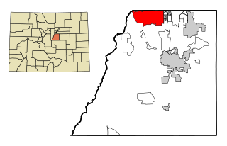
The City of Idaho Springs is the statutory city that is the most populous municipality in Clear Creek County, Colorado, United States. Idaho Springs is a part of the Denver–Aurora–Lakewood, CO Metropolitan Statistical Area. As of the 2020 census it had a population of 1,782. Idaho Springs is located in Clear Creek Canyon, in the mountains upstream from Golden, some 30 miles (50 km) west of Denver.

<span class="mw-page-title-main">Alamosa, Colorado</span> City in Colorado, United States

Alamosa is a home rule municipality and the county seat of Alamosa County, Colorado, United States. The city population was 9,806 in the 2020 United States Census. The city is the commercial center of the San Luis Valley in south-central Colorado, and is the home of Adams State University.

<span class="mw-page-title-main">Las Animas, Colorado</span> City in Colorado, United States

Las Animas is the statutory city that is the county seat, the most populous community, and the only incorporated municipality in Bent County, Colorado, United States. The city population was 2,300 at the 2020 United States Census. Las Animas is located on the Arkansas River, just west of its confluence with the Purgatoire River, in southeast Colorado east of Pueblo, near the historic Bent's Fort.

<span class="mw-page-title-main">Highlands Ranch, Colorado</span> Census Designated Place in Colorado, United States

Highlands Ranch is an unincorporated community and a census-designated place (CDP) located in and governed by Douglas County, Colorado, United States. The CDP is a part of the Denver–Aurora–Lakewood, CO Metropolitan Statistical Area. The population of the Highlands Ranch CDP was 105,631 at the 2020 census, making it the most populous unincorporated community in the State of Colorado. The Highlands Ranch Metropolitan District provides services to the community, which lies in ZIP Codes 80126, 80129, 80130, and 80163.

<span class="mw-page-title-main">Monument, Colorado</span> Town in Colorado, United States

Monument is a home rule town situated at the base of the Rampart Range in El Paso County, Colorado, United States. Monument is one of the three communities that make up the Tri-Lakes area, along with Palmer Lake and Woodmoor. The town is part of the Colorado Springs metropolitan area, which had an estimated population of 700,000 in 2019. Monument is bordered by Pike National Forest on the west, Colorado Springs and the United States Air Force Academy to the south, Bald Mountain, True Mountain, and Spruce Mountain to the north, and Black Forest and rolling plains to the east. Monument was first settled as a stop along the Rio Grande Railroad in 1872, and the area was incorporated as a town called Henry's Station in 1879, but the name was later changed to Monument. The town population was 10,399 at the 2020 United States Census, an increase from the population of 5,530 in 2010 and 1,971 in 2000. On April 1, 2019, the town declared itself to be a Second Amendment sanctuary.

<span class="mw-page-title-main">Penrose, Colorado</span> Unincorporated community in Fremont County, Colorado, United States

Penrose is a census-designated place (CDP) and post office located in and governed by Fremont County, Colorado, United States. The CDP is a part of the Cañon City, CO Micropolitan Statistical Area. The Penrose post office has the ZIP Code 81240. At the United States Census 2020, the population of the Penrose CDP was 3,685.

<span class="mw-page-title-main">Gunnison, Colorado</span> City in Colorado, United States

Gunnison is a home rule municipality that is the county seat and the most populous municipality of Gunnison County, Colorado. The city population was 6,560 at the 2020 United States Census. The city was named in honor of John W. Gunnison, a United States Army officer who surveyed for a transcontinental railroad in 1853.

<span class="mw-page-title-main">Edgewater, Colorado</span> City in Colorado, United States

The City of Edgewater is a home rule municipality located in Jefferson County, Colorado, United States. The city population was 5,005 at the 2020 United States Census. Edgewater is surrounded by Denver to the east, Lakewood to the south and west, and Wheat Ridge to the north. The city is a part of the Denver–Aurora–Lakewood, CO Metropolitan Statistical Area and the Front Range Urban Corridor.

<span class="mw-page-title-main">Cortez, Colorado</span> City in Colorado, United States

Cortez is a home rule municipality that is the county seat and the most populous municipality of Montezuma County, Colorado, United States. The city population was 8,766 at the 2020 United States Census.

<span class="mw-page-title-main">Colorado City, Colorado</span> Census-designated place in Pueblo County, Colorado, United States

Colorado City is a census-designated place (CDP) and post office in and governed by Pueblo County, Colorado, United States. The CDP is a part of the Pueblo, CO Metropolitan Statistical Area. The Colorado City post office has the ZIP Code 81019. At the United States Census 2020, the population of the Colorado City CDP was 2,237. The Colorado City Metropolitan District provides services.

<span class="mw-page-title-main">Rye, Colorado</span> Town in Colorado, United States

Rye is a Statutory Town in Pueblo County, Colorado, United States. The population was 206 at the 2020 census.

<span class="mw-page-title-main">Milton, Delaware</span> Town in Delaware, United States

Milton is a town in Sussex County, Delaware, United States, on the Delmarva Peninsula. It is located on the Broadkill River, which empties into Delaware Bay. The population was 2,576 at the 2010 census, an increase of 55.5% over the previous decade.

<span class="mw-page-title-main">West Pleasant View, Colorado</span> Census Designated Place in Colorado, United States

West Pleasant View is an unincorporated community and a census-designated place (CDP) located in and governed by Jefferson County, Colorado, United States. The CDP is a part of the Denver–Aurora–Lakewood, CO Metropolitan Statistical Area. The population of the West Pleasant View CDP was 4,327 at the United States Census 2020. The Pleasant View Metropolitan District provides services. The Golden post office serves the area.

<span class="mw-page-title-main">Diamond Beach, New Jersey</span> Populated place in Cape May County, New Jersey, US

Diamond Beach is an unincorporated community and census-designated place (CDP) located within Lower Township in Cape May County, in the U.S. state of New Jersey. The CDP, and all of Cape May County, is part of the Ocean City metropolitan statistical area, and is part of the Philadelphia-Wilmington-Camden, PA-NJ-DE-MD combined statistical area, also known as the Delaware Valley or Philadelphia metropolitan area. As of the United States 2020 Census, the CDP's population was 203, an increase of 67 from the 2010 census count of 136.

<span class="mw-page-title-main">North Valley, New Mexico</span> Census-designated place in New Mexico, United States

North Valley is a census-designated place (CDP) in Bernalillo County, New Mexico, United States. As of the 2010 Census, the CDP population was 11,333. It is part of the Albuquerque Metropolitan Statistical Area.

<span class="mw-page-title-main">San Felipe Pueblo, New Mexico</span> CDP in New Mexico, United States

San Felipe Pueblo is a census-designated place (CDP) in Sandoval County, New Mexico, United States, and is located 10 miles (16 km) north of Bernalillo. As of the 2000 census, the CDP population was 2,080. It is part of the Albuquerque Metropolitan Statistical Area.

<span class="mw-page-title-main">Artondale, Washington</span> CDP in Washington, United States

Artondale is a census-designated place (CDP) in Pierce County, Washington, United States. The population was 13,641 at the 2020 census.

<span class="mw-page-title-main">Beulah, Colorado</span> Unincorporated community in Pueblo County, Colorado, United States

Beulah is an unincorporated community and a post office located within the Beulah Valley census-designated place in Pueblo County, Colorado, United States. The Beulah Post Office has the ZIP code 81023. Beulah is a part of the Beulah Valley CDP. Beulah lies along State Highway 78 about 21 miles southwest of Pueblo, in the foothills of the Wet Mountains.

<span class="mw-page-title-main">Benton, California</span> Census-designated place in California, United States

Benton is a census-designated place (CDP) in Mono County, California, United States. It includes the unincorporated communities of Benton and Benton Hot Springs and is 32 miles (51 km) north of the community of Bishop, at an elevation of 5,387 feet (1,642 m). The population of the CDP was 279 at the 2020 census.

<span class="mw-page-title-main">Vineland, Colorado</span> Census-designated place in Pueblo County, Colorado, United States

Vineland is a census-designated place (CDP) in and governed by Pueblo County, Colorado, United States. The CDP is a part of the Pueblo, CO Metropolitan Statistical Area. The population of the Vineland CDP was 269 at the United States Census 2020. The Pueblo post office (Zip Code 81006) serves the area.

References

  1. 1 2 3 "State of Colorado Census Designated Places - BAS20 - Data as of January 1, 2020". United States Census Bureau . Retrieved December 27, 2020.
  2. 1 2 "U.S. Board on Geographic Names: Domestic Names". United States Geological Survey . Retrieved December 27, 2020.
  3. 1 2 United States Census Bureau. "Pueblo West CDP, Colorado" . Retrieved April 13, 2023.
  4. 1 2 "Look Up a ZIP Code". United States Postal Service . Retrieved December 27, 2020.
  5. "Land Concern Pleads Guilty to 19 Counts of Criminal Fraud".
  6. Harmon, Tracy (April 3, 2019). "Pueblo West Turns 50: Pueblo West founder turned rangeland into community". FowlerTribune.com. Archived from the original on April 6, 2019. Retrieved April 6, 2019.
  7. Prechtl, Joey (January 23, 2019). "Pueblo West Metro District to see if they can become a city or not". KKTV.com. KKTV. Archived from the original on April 6, 2019. Retrieved April 6, 2019.
  8. "Pueblo West CO Case Study | ClearGov". December 23, 2021. Retrieved June 25, 2023.
  9. "Pueblo West CO Case Study | ClearGov". December 23, 2021. Retrieved June 25, 2023.
  10. "Welcome to Pueblo West, Colorado! "Community Living in a Rural Setting"". Pueblo West Metropolitan District. Archived from the original on September 18, 2008. Retrieved March 7, 2011.
  11. "Bustang Schedule". RideBustang. CDOT.