Beulah Valley, Colorado

Last updated

Beulah Valley, Colorado
Beulah Valley, Colorado.JPG
Entering the Beulah Valley from the east on Colorado State Highway 78.
Pueblo County Colorado Incorporated and Unincorporated areas Beulah Valley Highlighted.svg
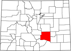
Location of the Beulah Valley CDP in Pueblo County, Colorado.
Usa edcp location map.svg
Red pog.svg
Beulah Valley
Location of the Beulah Valley CDP in the United States.
Coordinates: 38°04′16″N104°58′59″W / 38.0709797°N 104.9829873°W / 38.0709797; -104.9829873 (Beulah Valley CDP, Colorado) [1]
Country Flag of the United States.svg  United States
State Flag of Colorado.svg  Colorado
County Pueblo County
Government
[2]
  Type unincorporated community
Area
[1]
  Total2.572 sq mi (6.662 km2)
  Land2.571 sq mi (6.660 km2)
  Water0.0008 sq mi (0.002 km2)
Elevation
[2]
6,411 ft (1,954 m)
Population
 (2020) [1]
  Total518
  Density200/sq mi (78/km2)
Time zone UTC-7 (MST)
  Summer (DST) UTC-6 (MDT)
ZIP Code [3]
Beulah 81023
Area code 719
GNIS feature [2] Beulah Valley CDP

Beulah Valley is a census-designated place (CDP) in and governed by Pueblo County, Colorado, United States. The CDP is a part of the Pueblo, CO Metropolitan Statistical Area. The population of the Beulah Valley CDP was 518 at the United States Census 2020. [1] The Beulah post office (Zip Code 81023) serves the area. [3]

Contents

Bishop Castle, constructed by Jim Bishop, otherwise known as a "one man castle", is located between Beulah and San Isabel, Colorado.

Geography

The Beulah Valley CDP has an area of 1,646 acres (6.662 km2), including 0.49 acres (0.002 km2) of water. [1]

Demographics

Beulah Valley CDP, Colorado
YearPop.±%
2000 1,164    
2010 556−52.2%
2020 518−6.8%
Source: United States Census Bureau


The United States Census Bureau initially defined the Beulah Valley CDP for the United States Census 2000.

See also

Related Research Articles

<span class="mw-page-title-main">Columbine, Colorado</span> Census-designated place in Jefferson and Arapahoe counties in Colorado, United States

Columbine is census-designated place (CDP) in and governed by Jefferson and Arapahoe counties in Colorado, United States. The CDP is a part of the Denver metropolitan area. Located primarily in Jefferson County, Columbine lies immediately south of Denver. The population of the Columbine CDP was 25,229 at the 2020 census. The community lies in ZIP code 80123.

<span class="mw-page-title-main">The Pinery, Colorado</span> Census Designated Place in Colorado, United States

The Pinery is an unincorporated community and a census-designated place (CDP) located in and governed by Douglas County, Colorado, United States. The CDP is a part of the Denver–Aurora–Lakewood, CO Metropolitan Statistical Area. The population of The Pinery CDP was 11,311 at the United States Census 2020. Douglas County governs the unincorporated community. The Parker post office serves the area.

<span class="mw-page-title-main">Westcreek, Colorado</span> Census Designated Place in Colorado, United States

Westcreek is an unincorporated community and a census-designated place (CDP) located in and governed by Douglas County, Colorado, United States. The CDP is a part of the Denver–Aurora–Lakewood, CO Metropolitan Statistical Area. The population of the Westcreek CDP was 120 at the United States Census 2020. The Sedalia post office serves the area.

<span class="mw-page-title-main">Edwards, Colorado</span> Census Designated Place in Colorado, United States

Edwards is an unincorporated town, a post office, and a census-designated place (CDP) located in and governed by Eagle County, Colorado, United States. Edwards is the principal town of the Edwards, CO Micropolitan Statistical Area. The Edwards post office has the ZIP Code 81632. At the United States Census 2020, the population of the Edwards CDP was 11,246. The Edwards Metropolitan District provides services.

<span class="mw-page-title-main">El Jebel, Colorado</span> Census Designated Place in Colorado, United States

El Jebel is an unincorporated community and a census-designated place (CDP) located in and governed by Eagle County, Colorado, United States. The CDP is a part of the Edwards, CO Micropolitan Statistical Area. The population of the El Jebel CDP was 4,130 at the United States Census 2020. The Carbondale Post Office serves El Jebel postal addresses.

<span class="mw-page-title-main">Kittredge, Colorado</span> Census Designated Place in Colorado, United States

Kittredge is an unincorporated town, a post office, and a census-designated place (CDP) located in and governed by Jefferson County, Colorado, United States. The CDP is a part of the Denver–Aurora–Lakewood, CO Metropolitan Statistical Area. The Kittredge post office has the ZIP code 80457. At the United States Census 2020, the population of the Kittredge CDP was 1,308.

<span class="mw-page-title-main">Avondale, Colorado</span> Census-designated place in Pueblo County, Colorado, United States

Avondale is a census-designated place (CDP) and post office in and governed by Pueblo County, Colorado, United States. The CDP is a part of the Pueblo, CO Metropolitan Statistical Area. The Avondale post office has the ZIP Code 81022. At the United States Census 2020, the population of the Avondale CDP was 594, while the population of the 81022 ZIP Code Tabulation Area was 1,624 including adjacent areas.

<span class="mw-page-title-main">Colorado City, Colorado</span> Census-designated place in Pueblo County, Colorado, United States

Colorado City is a census-designated place (CDP) and post office in and governed by Pueblo County, Colorado, United States. The CDP is a part of the Pueblo, CO Metropolitan Statistical Area. The Colorado City post office has the ZIP Code 81019. At the United States Census 2020, the population of the Colorado City CDP was 2,237. The Colorado City Metropolitan District provides services.

<span class="mw-page-title-main">Salt Creek, Colorado</span> Census Designated Place in Colorado, United States

Salt Creek is an unincorporated community and a census-designated place (CDP) located in and governed by Pueblo County, Colorado, United States. The CDP is a part of the Pueblo, CO Metropolitan Statistical Area. The population of the Salt Creek CDP was 507 at the United States Census 2020. The Pueblo post office (Zip Code 81006) serves the area.

<span class="mw-page-title-main">Dotsero, Colorado</span> Census Designated Place in Colorado, United States

Dotsero is an unincorporated community and a census-designated place (CDP) located in and governed by Eagle County, Colorado, United States. The CDP is a part of the Edwards, CO Micropolitan Statistical Area. The population of the Dotsero CDP was 1,172 at the United States Census 2020. The Gypsum post office serves the area.

<span class="mw-page-title-main">Coaldale, Colorado</span> Census-designated place in Fremont County, Colorado, United States

Coaldale is a census-designated place (CDP) and post office located in and governed by Fremont County, Colorado, United States. The CDP is a part of the Cañon City, CO Micropolitan Statistical Area. The Coaldale post office has the ZIP Code 81222. At the United States Census 2020, the population of the Coaldale CDP was 343.

<span class="mw-page-title-main">Weldona, Colorado</span> Census Designated Place in Colorado, United States

Weldona is an unincorporated town, a post office, and a census-designated place (CDP) located in and governed by Morgan County, Colorado, United States. The CDP is a part of the Fort Morgan, CO Micropolitan Statistical Area. The Weldona post office has the ZIP Code 80653. At the United States Census 2020, the population of the Weldona CDP was 113.

<span class="mw-page-title-main">Wolcott, Colorado</span> Census Designated Place in Colorado, United States

Wolcott is an unincorporated town, a post office, and a census-designated place (CDP) located in and governed by Eagle County, Colorado, United States. The CDP is a part of the Edwards, CO Micropolitan Statistical Area. The Wolcott post office has the ZIP Code 81655. At the United States Census 2020, the population of the Wolcott CDP was 20.

<span class="mw-page-title-main">Lazy Acres, Colorado</span> Census Designated Place in Colorado, United States

Lazy Acres is an unincorporated community and a census-designated place (CDP) located in and governed by Boulder County, Colorado, United States. The CDP is a part of the Boulder, CO Metropolitan Statistical Area. The population of the Lazy Acres CDP was 957 at the United States Census 2020. The Boulder post office serves the area.

<span class="mw-page-title-main">Leyner, Colorado</span> Census Designated Place in Colorado, United States

Leyner is an unincorporated community and a census-designated place (CDP) located in and governed by Boulder County, Colorado, United States. The CDP is a part of the Boulder, CO Metropolitan Statistical Area. The population of the Leyner CDP was 40 at the United States Census 2020. The Lafayette post office serves the area.

<span class="mw-page-title-main">Valmont, Colorado</span> Census Designated Place in Colorado, United States

Valmont is an unincorporated community and a census-designated place (CDP) located in and governed by Boulder County, Colorado, United States. The CDP is a part of the Boulder, CO Metropolitan Statistical Area. The population of the Valmont CDP was 64 at the United States Census 2020. The Boulder post office serves the area.

<span class="mw-page-title-main">Catherine, Colorado</span> Census-designated place in Garfield County, Colorado, United States

Catherine is a census-designated place (CDP) in and governed by Garfield County, Colorado, United States. The CDP is a part of the Glenwood Springs, CO Micropolitan Statistical Area. The population of the Catherine CDP was 235 at the United States Census 2020. The Glenwood Springs post office serves the area.

<span class="mw-page-title-main">Blende, Colorado</span> Census-designated place in Pueblo County, Colorado, United States

Blende is a Census-designated place (CDP) in and governed by Pueblo County, Colorado, United States. The CDP is a part of the Pueblo, CO Metropolitan Statistical Area. The population of the Blende CDP was 788 at the United States Census 2020. The Pueblo post office (Zip Code 81006) serves the area.

<span class="mw-page-title-main">Vineland, Colorado</span> Census-designated place in Pueblo County, Colorado, United States

Vineland is a census-designated place (CDP) in and governed by Pueblo County, Colorado, United States. The CDP is a part of the Pueblo, CO Metropolitan Statistical Area. The population of the Vineland CDP was 269 at the United States Census 2020. The Pueblo post office (Zip Code 81006) serves the area.

<span class="mw-page-title-main">Norrie, Colorado</span> Unincorporated community in Pitkin County, Colorado, United States

Norrie is a census-designated place (CDP) located in and governed by Pitkin County, Colorado, United States. The population of the Norrie CDP was 7 at the United States Census 2020. The Meredith post office (Zip Code 81642) serves the area. The CDP is a part of the Glenwood Springs, CO Micropolitan Statistical Area.

References

  1. 1 2 3 4 5 "State of Colorado Census Designated Places - BAS20 - Data as of January 1, 2020". United States Census Bureau . Retrieved November 3, 2021.
  2. 1 2 3 "U.S. Board on Geographic Names: Domestic Names". United States Geological Survey . Retrieved December 26, 2020.
  3. 1 2 "Zip Code 81023 Map and Profile". zipdatamaps.com. 2020. Retrieved December 26, 2020.