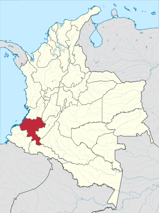
Cauca Department is a department of Southwestern Colombia. Located in the southwestern part of the country, facing the Pacific Ocean to the west, the Valle del Cauca Department to the north, Tolima Department to the northeast, Huila Department to the east, and Nariño Department to the south. Putumayo and Caqueta Departments border the southeast portion of Cauca Department as well. It covers a total area of 29,308 km2 (11,316 sq mi), the 13th largest in Colombia. Its capital is the city of Popayán. The offshore island of Malpelo belongs to the department. It is located in the southwest of the country, mainly in the Andean and Pacific regions plus a tiny part (Piamonte) in the Amazonian region. The area makes up 2.56% of the country.

Barrancabermeja is a municipality and city in Colombia, located on the shore of the Magdalena River, in the western part of the department of Santander. It is home to the largest oil refinery in the country, under direct management of ECOPETROL. Barrancabermeja is known as the Oil Capital of Colombia.

Puerto Boyacá is a Colombian river-port town and municipality by the Magdalena River in the Boyacá Department, where is also considered a Special Trade Zone due to its port status. Its main industries are oil exploration and processing. In the 1980s and early 1990s, Puerto Boyacá was affected intensively by the Colombian Armed Conflict.

Puerto Berrío is a municipality and town in the Colombian department of Antioquia. It is part of the Magdalena Medio Antioquia sub-region.

Puerto Triunfo is a town and municipality in Antioquia Department, Colombia. It is part of the Magdalena Medio Antioquia sub-region.

San Carlos is a town and municipality in the Colombian department of Antioquia, part of the subregion of Eastern Antioquia. It is called the hydro-electrical capital of Colombia, because it has many dams and it produces much energy. The population was 14,480 at the 2018 census.

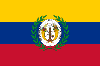
United States of Colombia was the name adopted in 1863 by the Constitución de Rionegro for the Granadine Confederation, after years of civil war. Colombia became a federal state itself composed of nine "sovereign states.” It comprised the present-day nations of Colombia and Panama and parts of northwestern Brazil. After several more years of intermittent civil wars, it was replaced by the more centralist Republic of Colombia in 1886, predecessor to modern Colombia.
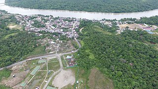
Atrato is a municipality and town in the Chocó Department near the Pacific Ocean, Colombia.

Vélez is a town and municipality of the Santander Department in northeastern Colombia.
The Colombian Navy, officially the Colombian National Navy, also known as the "Armada Nacional" or just the "Armada" in Spanish, is the naval branch of the military forces of Colombia. The Navy is responsible for security and defence in the Colombian zones of both the Atlantic (Caribbean) and Pacific oceans, the extensive network of rivers inside the country, and a few small land areas under its direct jurisdiction.

The Granadine Confederation was a short-lived federal republic established in 1858 as a result of a constitutional change replacing the Republic of New Granada. It consisted of the present-day nations of Colombia and Panama and parts of northwestern Brazil. In turn, the Granadine Confederation was replaced by the United States of Colombia after another constitutional change in 1863.

Uribia is a town and municipality of the La Guajira department of Colombia. It is the youngest municipality of this Department since the year 2000. Northern Zone of the Cerrejón coal mines are located in this municipality. The municipality also contains the Serranía de Macuira mountain range which is an isolated low altitude mountain range in the middle of La Guajira Desert. One third of this mountain range is also a National Natural Park of Colombia.

Tibú is a municipality and town of Colombia located in the department of Norte de Santander, in the northeast of the country, on the border with Venezuela and on the banks of the Tibú River. It is the 160th most populated town of Colombia, and the 6th in the department after Cúcuta, Ocaña, Villa del Rosario, Los Patios and Pamplona. It has an airport, and is connected by national road with Cúcuta, Ocaña and El Tarra.

Barichara is a town and municipality in the Santander Department in northeastern Colombia.

Jesus María is a town and municipality in the Santander Department, in northeastern Colombia.

Jordán is a town and municipality in the Santander Department in northeastern Colombia.
Puerto Wilches is a town and municipality in the Santander Department in northeastern Colombia.
Gran Colombia, or Greater Colombia, officially the Republic of Colombia, was a state that encompassed much of northern South America and part of southern Central America from 1819 to 1831. It included present-day Colombia, mainland Ecuador, Panama, and Venezuela, along with parts of northern Peru, northwestern Brazil, and claimed the Essequibo region. The terms Gran Colombia and Greater Colombia are used historiographically to distinguish it from the current Republic of Colombia, which is also the official name of the former state.
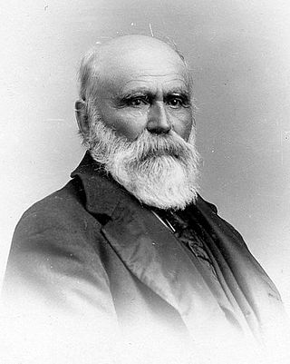
José Bonifacio Aquileo Elias Parra y Gómez de la Vega was a Colombian soldier, businessman and political figure. He was the President of Colombia between 1876 and 1878.
Banco Crédito y Ahorro Ponceño was the first bank in Ponce, Puerto Rico, and one of the first two native Puerto Rican banks to be established in Puerto Rico. The bank was the first one to introduce a bank credit card to the Puerto Rican market. With over 50 branches throughout the island, the bank was one of the largest banking companies in Puerto Rico during most of the twentieth century.