Woodbridge Township is a township in northern Middlesex County, in the U.S. state of New Jersey. The township is a regional hub of transportation and commerce for central New Jersey and a major bedroom suburb of New York City, within the New York metropolitan area. Located within the core of the Raritan Valley region, Woodbridge Township hosts the junction of the New Jersey Turnpike and the Garden State Parkway, the two busiest highways in the state, and also serves as the headquarters for the New Jersey Turnpike Authority, which operates both highways.

Honey Brook is a borough in Chester County, Pennsylvania, United States. The population of the borough was 1,895 at the 2020 census. The borough is surrounded by Honey Brook Township, and both are referred to locally collectively as Honey Brook.

The Raritan River is a major river of New Jersey. Its watershed drains much of the mountainous area of the central part of the state, emptying into the Raritan Bay on the Atlantic Ocean.

The Rockaway River is a tributary of the Passaic River, approximately 35 mi (56 km) long, in Morris County, New Jersey in the United States. The upper course of the river flows through a wooded mountainous valley, whereas the lower course flows through the populated New Jersey suburbs and former industrial area west of New York City. It drains an area of approximately 130 sq mi (340 km²).
The Rahway River is a river in Essex, Middlesex, and Union Counties, New Jersey, United States, The Rahway, along with the Elizabeth River, Piles Creek, Passaic River, Morses Creek, the Fresh Kills River, has its river mouth at the Arthur Kill.

The South Branch Raritan River is a 50-mile-long (80 km) tributary of the Raritan River in New Jersey.

The North Branch Raritan River is a tributary of the Raritan River in central New Jersey.
Manalapan Brook is a tributary of the South River in Monmouth and Middlesex counties, New Jersey in the United States.

The Millstone River is a 38.6-mile-long (62.1 km) tributary of the Raritan River in central New Jersey in the United States.
New Jersey's 12th congressional district is represented by Democrat Bonnie Watson Coleman, who has served in Congress since 2015. The district is known for its research centers and educational institutions such as Princeton University, Rider University, The College of New Jersey, Institute for Advanced Study, Johnson & Johnson and Bristol-Myers Squibb. The district is primarily suburban in character, covering portions of Mercer, Somerset, Union, and Middlesex counties, although the district contains the state capital of Trenton as well as the smaller city of Plainfield.
New Jersey's 6th congressional district is represented by Democrat Frank Pallone, who has served the district in Congress since 1993. The district includes the northern and eastern portions of Middlesex County and the coastal areas of Monmouth County, including towns along the Raritan Bay.

Stirling is a NJ Transit station in the Stirling neighborhood of Long Hill Township, New Jersey along the Gladstone Branch of the Morris and Essex line. The station consists of one side platform, as well as a concrete block shelter constructed in August 1974 after the former Delaware, Lackawanna and Western Railroad depot was demolished. The Erie Lackawanna Railroad demolished the old depot on August 14, 1972 without notifying then-Passaic Township.

Middle Brook is a tributary of the Raritan River in Somerset County, New Jersey. The stream can be referred to as Rha-weigh-weiros, a Native American name meaning "running from a deep hole", on early maps of the area.
The South Branch Penobscot River is a river in Somerset County, Maine. Its source, Penobscot lake, the north end of which at is about 1,000 feet (300 m) from the Canada–United States border in Sandy Bay. This section of the border runs along the height of land separating the watersheds of the Penobscot River and the Monument River, which feeds into the Saint Lawrence River.

Heards Brook is a stream in Woodbridge Township, Middlesex County, New Jersey, United States.
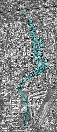
The Woodbrige River is a river in Woodbridge Township, Middlesex County, New Jersey, United States. The river is an important waterway, which frequently floods due to extreme weather caused by climate change, and is expected to increase doing so because of sea level rise. The river includes several conservation areas to protect the diversity of wildlife in the waterway, and the local government is increasingly buying out properties as part of a managed retreat to buffer other properties in the township.
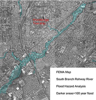
The South Branch Rahway River flows north north through Woodbridge Township, New Jersey before entering the Rahway River in Rahway, New Jersey, 4.5 miles from the Arthur Kill. Its source is the Roosevelt Park lake in Edison, New Jersey.
Smith Creek is a stream in Woodbridge Township, New Jersey, United States, emptying into the Arthur Kill 0.5 miles (0.80 km) north of the Woodbridge River. It was named for John Smith, one of the group who in 1667 purchased the land parcel from Governor Philip Carteret that became Woodbridge. Its navigable length is 0.6 miles (0.97 km), and there are nine marinas in that stretch. The creek draws less than 3 to 3.5 feet of water, limiting its use to shallow draft boats. Dredging of the creek in the region of the marinas was a 2013 priority for Woodbridge Township after Hurricane Sandy. The creek is a "minor freshwater tributary" to Arthur Kill, with higher flows in the spring, and less in late summer and fall. Public Service Enterprise Group has a generating station 0.6 miles (0.97 km) north of the mouth of Smith Creek. One mile north of the mouth is an oil refining and storage facility. In 2013 "corrective action" was taken against the Hess Corporation, after selling the property, for soil and groundwater contamination, including arsenic, lead and benzene. An old reference states:
Transatlantic sailing vessels once docked in Woodbridge, but silt from the clay pits converted Smith Creek into an inconsequential brook. Until the 1880s Woodbridge was a fashionable watering place. The Arthur Kill is now so spoiled by oil and sewage even gulls avoid it.
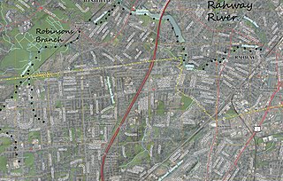
Robinsons Branch is a tributary of the Rahway River in Union and Middlesex Counties, New Jersey, United States.
The Robinson's Branch Reservoir is a decommissioned water reservoir in Clark, New Jersey. It is the largest body of water in Union County.