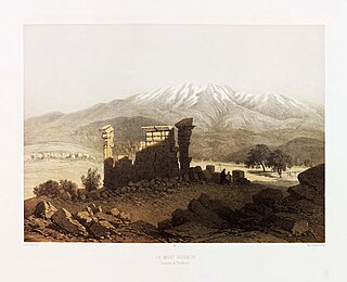
Mount Hermon is a mountain cluster constituting the southern end of the Anti-Lebanon mountain range. Its summit straddles the border between Syria and Lebanon and, at 2,814 m (9,232 ft) above sea level, is the highest point in Syria. On the top, in the United Nations buffer zone between Syrian and Israeli-occupied territories, is the highest permanently manned UN position in the world, known as "Hermon Hotel", located at 2814 metres altitude (9,232 ft). The southern slopes of Mount Hermon extend to the Israeli-occupied portion of the Golan Heights, where the Mount Hermon ski resort is located with a top elevation of 2,040 m (6,690 ft). A peak in this area rising to 2,236 m (7,336 ft) is the highest elevation in Israeli-controlled territory.

Rashaya, Rachaya, Rashaiya, Rashayya or Rachaiya, also known as Rashaya al-Wadi or Rachaya el-Wadi, is a town of the Rashaya District in the west of the Beqaa Government of Lebanon. It is situated at around 1,200 metres (3,900 ft) above sea level on the western slopes of Mount Hermon, south east of Beirut near the Syrian border, and approximately halfway between Jezzine and Damascus.

Kaukaba, Kaukabet El-Arab or Kaukaba Station is a village in the Hasbaya District in the Nabatiye Governorate in southern Lebanon.
Deir El Aachayer is a village north of Rashaya, in the Rashaya District and south of the Beqaa Governorate in Lebanon.

Aaiha is a village, plain, lake, and temporary wetland situated in the Rashaya District and south of the Beqaa Governorate in Lebanon. It is located in an intermontane basin near Mount Hermon and the Syrian border, approximately halfway between Rashaya and Kfar Qouq.
Yanta is a village situated in Rashaya District, Beqaa Governorate, Lebanon, 79 kilometres (49 mi) from Beirut. It is located close to the Syrian border north of Kfar Qouq.

Hebbariye, Hebbariyeh, Hebbariya or Hebariya is a village and municipality situated in the Hasbaya District of the Nabatieh Governorate in Lebanon. It is located on the southwestern slopes of Mount Hermon near the Lebanon–Syria border, northeast of Rachaya Al Foukhar and is positioned amongst orchards of apricot trees. There it is a roman temple.

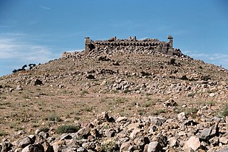
The Temples of Mount Hermon are around thirty Roman shrines and Roman temples that are dispersed around the slopes of Mount Hermon in Lebanon, Israel and Syria. A few temples are built on former buildings of the Phoenician & Hellenistic era, but nearly all are considered to be of Roman construction and were largely abandoned during the persecution of pagans in the late Roman Empire.
Nebi Safa, Nabi Safa, Neby Sufa, An Nabi Safa, An Nabi Safa' or En Nabi Safa also known as Mazraet Selsata or Thelthatha is a village in the Kfar Mishki municipality situated 13 kilometres (8.1 mi) west of Rashaya in the Rashaya District of the Beqaa Governorate in Lebanon.
Aaqbe, Akbeh, Aqbe, Akbe, Aaqabet, el-Aaqbe, Akraba, Aaqabet Rashaya or Akabe (العقبه) is a village and municipality situated 3 kilometres (1.9 mi) west of Rashaya in the Rashaya District of the Beqaa Governorate in Lebanon.
Khirbet El-Knese, El-Knese or El Knese are two Roman temples south of Yanta, north of Rashaya in the Rashaya District of the Beqaa Governorate in Lebanon.
Bakka, Bekka or Beka is a village and municipality situated 85 kilometres (53 mi) east of Beirut in the Rashaya District of the Beqaa Governorate in Lebanon. The population of the village is Sunni.
Burqush or Burkush is an archaeological site situated 30 kilometres (19 mi) west of Damascus, Syria.

Ain Aata, Ain Ata, 'Ain 'Ata or Ayn Aata is a village and municipality situated southwest of Rashaya, 99 kilometres (62 mi) south-east of Beirut, in the Rashaya District of the Beqaa Governorate in Lebanon.
Jdeidat Yabous, previously known as Ainkania, is a village situated 45 kilometres (28 mi) west of Damascus, Syria. According to the Syria Central Bureau of Statistics, the village had a population of 994 in the 2004 census.
Kafr Hawr is a Syrian village situated 35 kilometres (22 mi) southwest of Damascus. According to the Syria Central Bureau of Statistics, the village had a population of 2,957 in the 2004 census.

Mdoukha is a village and municipality 72 kilometres (45 mi) east of Beirut in the Rashaya District, Beqaa Governorate, Lebanon. A significant majority of the population is considered to be Lebanese Canadian, with 60% living in London, Ontario. Most of the population identifies as Sunni Muslim.

The Temples of the Beqaa Valley are a number of shrines and Roman temples that are dispersed around the Beqaa Valley in Lebanon. The most important and famous are those in Roman Heliopolis. A few temples are built on former buildings of the Phoenician & Hellenistic era, but all are considered to be of Roman construction and were started to be abandoned after the fourth century with the fall of the Roman Paganism.

Yammoune is a lake, nature reserve, village and municipality situated 27 kilometres (17 mi) northwest of Baalbek in Baalbek District, Baalbek-Hermel Governorate, Lebanon. The village has a few hundred inhabitants.

The Roman temple of Bziza is a well-preserved first century AD building dedicated to Azizos, a personification of the morning star in ancient Arab polytheism. This Roman temple lends the modern Lebanese town of Bziza its current name, as Bziza is a corruption of Beth Azizo meaning the house or temple of Azizos. Azizos was identified as Ares by Emperor Julian.