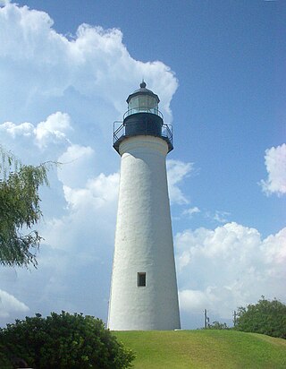
Port Isabel is a city in Cameron County, Texas, United States. It is part of the Brownsville–Harlingen–Raymondville and the Matamoros–Brownsville metropolitan areas. The population was 5,028 at the 2020 census.

South Padre Island is a resort town in Cameron County, Texas, United States. It is part of the Brownsville–Harlingen Metropolitan Statistical Area. The population was 2,066 at the 2020 census. The town is located on South Padre Island, a barrier island with the Laguna Madre situated to the leeward of the island and the Gulf of Mexico on the windward flank, along the Texas Gulf Coast. South Padre Island is accessible via the Queen Isabella Causeway from the town of Port Isabel. South Padre Island is named after José Nicolás Ballí, a Catholic priest and settler.

The Gulf Intracoastal Waterway (GIWW) is the portion of the Intracoastal Waterway located along the Gulf Coast of the United States. It is a navigable inland waterway running approximately 1,300 mi (2,100 km) from Saint Marks, Florida, to Brownsville, Texas.

South Padre Island is a barrier island in the U.S. state of Texas. The remote landform is located in Cameron County, Willacy County, and accessible by the Queen Isabella Causeway. South Padre Island was formed when the creation of the Port Mansfield Channel split Padre Island in two. The resort city of South Padre Island, a popular vacation destination, is located on the island.

Galveston Bay is a bay in the western Gulf of Mexico along the upper coast of Texas. It is the seventh-largest estuary in the United States, and the largest of seven major estuaries along the Texas Gulf Coast. It is connected to the Gulf of Mexico and is surrounded by sub-tropical marshes and prairies on the mainland. The water in the bay is a complex mixture of sea water and fresh water, which supports a wide variety of marine life. With a maximum depth of about 10 feet (3 m) and an average depth of only 6 feet (2 m), it is unusually shallow for its size.

The Lake Pontchartrain Causeway, also known simply as The Causeway, is a fixed link composed of two parallel bridges crossing Lake Pontchartrain in southeastern Louisiana, United States. The longer of the two bridges is 23.83 miles (38.35 km) long. The southern terminus of the causeway is in Metairie, Louisiana, and the northern terminus is in Mandeville, Louisiana. Both are in the New Orleans metropolitan area.

The Sanibel Causeway is a causeway in Southwest Florida that spans San Carlos Bay, connecting Sanibel Island with the Florida mainland in Punta Rassa. The causeway consists of three separate two-lane bridge spans, and two-man-made causeway islands between them. The entire causeway facility is owned by Lee County and operated by the Lee County Department of Transportation (DOT). The causeway is 3 miles (5 km) long with a $6 toll for island-bound vehicles only.
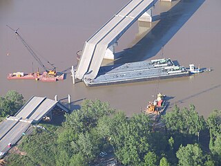
The I-40 bridge disaster was a bridge collapse that occurred southeast of Webbers Falls, Oklahoma, United States at 7:45 a.m. on May 26, 2002. Freight barges being transported on the Arkansas River collided with a pier supporting the Interstate 40 road bridge crossing the river. The resulting failure of the supports caused a section of the bridge to collapse, killing 14 people and injuring another 11. The collision was determined to have resulted from the captain of the barges' towboat losing consciousness.

State Highway 100 is a Texas state highway that runs 24 miles (39 km) between "Russeltown" and Port Isabel. It was designated in 1926 along its current route. Its western terminus is at Interstate 69E/U.S. Highway 77/83 and ends at the western end of the Queen Isabella Memorial Causeway at Port Isabel. The route continues as Texas Park Road 100 east and north to a dead end on South Padre Island.

The Hillsborough River Bridge is a bridge crossing the Hillsborough River estuary between Charlottetown and Stratford in Queens County, Prince Edward Island. The current road bridge, built in 1962, replaced a 1905 rail bridge crossing the same span which was known by the same name.
The John F. Kennedy Memorial Causeway is a paved highway located in Corpus Christi, Texas. The causeway crosses the Laguna Madre and connects North Padre Island with Flour Bluff on the Texas mainland.
Pelican Island is an island located in Galveston County, Texas. It is part of the city of Galveston and is linked to Galveston Island by the Pelican Island causeway. The island is home to the Texas A&M University at Galveston as well as two museum ships—the destroyer escort USS Stewart (DE-238) and the submarine USS Cavalla (SS-244)—and Seawolf Park. Seawolf Parkway is the only street that runs across the island.

The Laguna Madre is a long, shallow, hypersaline lagoon along the western coast of the Gulf of Mexico in Nueces, Kenedy, Kleberg, Willacy and Cameron Counties in Texas, United States. It is one of seven major estuaries along the Gulf Coast of Texas. The roughly 20-mile (32 km) long Saltillo Flats land bridge divides it into Upper and Lower lagoons joined by the Intracoastal Waterway, which has been dredged through the lagoon. Cumulatively, Laguna Madre is approximately 130 miles (210 km) long, the length of Padre Island in the US. The main extensions include Baffin Bay in Upper Laguna Madre, Red Fish Bay just below the Saltillo Flats, and South Bay near the Mexican border. As a natural ecological unit, the Laguna Madre of the United States is the northern half of the ecosystem as a whole, which extends into Tamaulipas, Mexico approximately 144 miles (232 km) south of the US border, to the vicinity of the Rio Soto La Marina and the town of La Pesca, extending approximately 275 miles (443 km) through USA and Mexico in total.
Ocean Tower SPI was an unfinished, 31-story condominium in South Padre Island, Cameron County, Texas, United States, that was imploded when it was deemed unsafe to remain standing. Construction was halted in May 2008 when cracks formed in the building's supporting columns, and investigations revealed that the core of the skyscraper had sunk by more than 14 inches (360 mm). Though the developers initially vowed to fix the problem, studies discovered that repairs would have been too expensive, and plans for its demolition were announced in September 2009. At the time of its controlled implosion in December 2009 the building weighed 55,000 short tons (50,000 t), and it was the tallest reinforced concrete structure to be demolished in that way. It was nicknamed "Faulty Towers" and "The Leaning Tower of South Padre Island".

Weeks 533 is a 500-short-ton (454 t) capacity Clyde Iron Works model 52 barge-mounted crane which is the largest revolving floating crane on the East Coast of the United States. It was originally ordered for bridge construction and has since been used in several notable heavy lifts.

Park Road 100 is a park road in the Rio Grande Valley in Cameron County, in the U.S. state of Texas. It runs along South Padre Island through the town of the same name.

The U.S. state of Texas has a series of estuaries along its coast on the Gulf of Mexico, most of them bounded by the Texas barrier islands. Estuaries are coastal bodies of water in which freshwater from rivers mixes with saltwater from the sea. Twenty-one drainage basins terminate along the Texas coastline, forming a chain of seven major and five minor estuaries: listed from southwest to northeast, these are the Rio Grande Estuary, Laguna Madre, the Nueces Estuary, the Mission–Aransas Estuary, the Guadalupe Estuary, the Colorado–Lavaca Estuary, East Matagorda Bay, the San Bernard River and Cedar Lakes Estuary, the Brazos River Estuary, Christmas Bay, the Trinity–San Jacinto Estuary, and the Sabine–Neches Estuary. Each estuary is named for its one or two chief contributing rivers, excepting Laguna Madre, East Matagorda Bay, and Christmas Bay, which have no major river sources. The estuaries are also sometimes referred to by the names of their respective primary or central water bodies, though each also includes smaller secondary bays, inlets, or other marginal water bodies.

Port Mansfield Channel or Mansfield Cut is an artificial waterway encompassing the Laguna Madre positioned at the 97th meridian west on the earth's longest barrier island known as Padre Island. During Post–World War II, the tidal inlet was dredged as a private channel differentiating North Padre Island better known as Padre Island National Seashore and South Padre Island. The navigable waterway was channeled during the late 1950s ceremoniously cresting the intertidal zone of the Gulf of Mexico by September 1957 on the Texas Gulf Coast.

Brazos Santiago Pass is a natural coastal landform located in the Lower Laguna Madre and Lower Rio Grande Valley on the furthest southern beach terrain of the Texas Gulf Coast. The seacoast passage is interpolated by barrier islands encompassing the southern Brazos Island and the northern South Padre Island.


