RTA Rapid Transit

Last updated
RTA Rapid Transit
GCRTA wordmark logo.svg
Cleveland Skyline 2015.png
Cleveland August 2015 01 (RTA Red Line).jpg
Cleveland August 2015 26 (RTA Blue Line).jpg
Overview
Owner Greater Cleveland Regional Transit Authority
Locale Cuyahoga County, Ohio
Transit type Rapid transit
Semi-metro
Number of lines1 rapid transit: Red
3 light rail: Blue, Green, Waterfront [1]
Number of stations18 rapid transit
34 light rail [1]
Daily ridership10,800 (rapid transit, weekdays, Q4 2023)
2,500 (light rail, weekdays, Q4 2023) [2]
Annual ridership3,469,100 (rapid transit, 2023)
661,500 (light rail, 2023) [3]
Operation
Began operationOctober 25, 1859;164 years ago (1859-10-25)
(first streetcar line);
December 17, 1913;110 years ago (1913-12-17)
(current lines)
;
March 15, 1955;69 years ago (1955-03-15)
(rapid transit);
October 11, 1980;43 years ago (1980-10-11)
(semi-metro)
Ended operationOctober 30, 1981;42 years ago (1981-10-30)
(last streetcar use)
Number of vehicles40 rapid transit cars
34 light rail cars [1]
Technical
System length19 mi (31 km) rapid transit
18 mi (29 km) light rail [1]
Track gauge 4 ft 8+12 in (1,435 mm) standard gauge
System map

Cleveland RTA Map.png

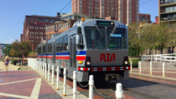
RTA Rapid Transit (generally known as The Rapid) is a rapid transit and semi-metro [4] system owned and operated by the Greater Cleveland Regional Transit Authority (GCRTA).

Contents

The system serves Cleveland and surrounding areas in Cuyahoga County. The system currently consists of four total service lines: one rapid transit rail line and three light rail lines.

Rail Lines

The four rail lines join at Tower City Center in downtown Cleveland, on the platform level of the former Cleveland Union Terminal.

Three rail lines share their tracks at Tri-C–Campus District and East 55th stations. This sharing of one route by light and heavy rail trains is quite unusual. The shared stations have connected platforms of two heights to accommodate the two kinds of trains. And the two types of trains both use the same maintenance facility since they both use the same track gauge and same source of power (overhead catenary).

Red Line

The Red Line, a heavy-rail route, runs in both directions on fully grade-separated rights-of-way built from 1955 to 1968. It serves Cleveland's southwest suburbs, with its southwestern terminus at Cleveland Hopkins International Airport. Heading northeast, the Red Line serves University Circle before heading to its northeastern terminus at the Louis Stokes Station at Windermere in East Cleveland.

Blue, Green, and Waterfront Lines

The Blue and Green light-rail lines (alternatively known as the RTA Shaker Rapid) were built from 1913 to 1936 as grade-separated lines closer to downtown and surface lines along street medians in the streetcar suburb of Shaker Heights.

The two lines part ways at Shaker Square, a historic mixed-use community in Cleveland proper, just west of the Shaker Heights border. The Blue Line veers southeast along Van Aken Boulevard until reaching its terminus near the intersection of Warrensville Center Road and Chagrin Boulevard (U.S. Route 422 and State Route 8). The Green line continues due east along Shaker Boulevard (State Route 87) until reaching its terminus at the intersection of Green Road.

Light rail vehicle on the Waterfront Line RTA Green Line train.png
Light rail vehicle on the Waterfront Line

The Waterfront Line, opened in 1996, extends the Blue and Green Lines from Tower City north through The Flats. It then travels northeast along the shoreline of Lake Erie, servicing the local Amtrak station and terminates at the Lakefront Municipal lot. The Waterfront light rail line provides access from Tower City Center to the Flats, Cleveland Browns Stadium, the Great Lakes Science Center, the Rock and Roll Hall of Fame, and Burke Lakefront Airport.

Stations

Cleveland Rapid Transit, 1913-present GCRTA 1913-2015.gif
Cleveland Rapid Transit, 1913–present

The RTA Rapid Transit system consists of a total of 47 stations. [5] The stations are fully or partially within the city limits of Cleveland, Shaker Heights, East Cleveland, and Brook Park.

Tower City on the Red, Blue, Green, and Waterfront Lines Cleveland Public Square Fountain (27441802124).jpg
Tower City on the Red, Blue, Green, and Waterfront Lines
Coventry on the Green Line Coventry station.jpg
Coventry on the Green Line
West 25th on the Red Line West 25th - Ohio City platform.jpg
West 25th on the Red Line
Lee-Van Aken on the Blue Line Lee-Van Aken station (6).jpg
Lee-Van Aken on the Blue Line
Settlers Landing on the Waterfront Line Settlers Landing station.jpg
Settlers Landing on the Waterfront Line
Airport on the Red Line Cleveland August 2015 03 (Cleveland Hopkins International Airport Station).jpg
Airport on the Red Line
Belvoir on the Green Line Belvoir Rapid Station October 2015.JPG
Belvoir on the Green Line
†*Terminus and transfer stations
Terminal stations
* Transfer stations
Closed stations
StationRapid Transit linesJurisdictionOpenedRebuilt ADA access
Airport Red Cleveland196819941994
Amtrak Waterfront Cleveland1997
Ashby Blue Shaker Heights19201981
Attleboro Green Shaker Heights19131980
Avalon Blue Shaker Heights19201981
Belvoir Green Shaker Heights19361980
Brookpark Red Cleveland / Brook Park196920172003
Buckeye–Woodhill* Blue Green Cleveland19201981, 20122012
Cedar–University Red Cleveland195520142002
Courtland Green Shaker Heights19151980
Coventry Green Cleveland / Shaker Heights19131980
Drexmore Blue Cleveland19481981
East 9th–North Coast Waterfront Cleveland19961996
East 55th* Red Blue Green Cleveland192020112011
East 79th Red Cleveland195520212021
East 79th* Blue Green Cleveland19201981
East 105th–Quincy Red Cleveland195520052005
East 116th–St. Luke's* Blue Green Cleveland19201981, 20192019
Eaton Green Shaker Heights19151980
Euclid–East 120th Red Cleveland1955
Farnsleigh Blue Shaker Heights19301981, 20192019
Flats East Bank Waterfront Cleveland19961996
Green Road Green Shaker Heights19361980, 19882001
Kenmore Blue Shaker Heights19201981
Lee–Shaker Green Shaker Heights19131980, 20172017
Lee–Van Aken Blue Shaker Heights19201981, 20152015
Little Italy–University Circle Red Cleveland20152015
Lynnfield Blue Shaker Heights19201981
Onaway Blue Shaker Heights19201980
Puritas–West 150th Red Cleveland196820112011
Settlers Landing Waterfront Cleveland19961996
Shaker Square* Blue Green Cleveland192019862006
South Harbor Waterfront Cleveland19961996
South Park Green Shaker Heights19131980
South Woodland Blue Cleveland / Shaker Heights19201981
Southington Blue Shaker Heights19201980
Southington Green Shaker Heights19131981
Superior Red East Cleveland195519961996
Tower City†* Red Blue Green Waterfront Cleveland193019901990
Tri-C–Campus District* Red Blue Green Cleveland19302003, 20182018
Triskett Red Cleveland195820002000
Warrensville–Shaker Green Shaker Heights19281980, 20162016
Warrensville–Van Aken Blue Shaker Heights19301981, 19991999
West 3rd Waterfront Cleveland19991999
West 25th–Ohio City Red Cleveland195519921992
West 65th–Lorain Red Cleveland195520042004
West 117th–Madison Red Cleveland195520072007
West Boulevard–Cudell Red Cleveland195519991999
West Green Green Shaker Heights19361980
West Park Red Cleveland195819961996
Windermere†* Red East Cleveland195519971997

Note: Euclid–East 120th Street station closed in 2015 and was replaced by Little Italy–University Circle station.

See also

Related Research Articles

<span class="mw-page-title-main">Greater Cleveland Regional Transit Authority</span> Public transit agency for the city and suburbs of Cleveland, Ohio, USA

The Greater Cleveland Regional Transit Authority is the public transit agency for Cleveland, Ohio, United States and the surrounding suburbs of Cuyahoga County. RTA is the largest transit agency in Ohio, with a ridership of 22,431,500, or about 75,300 per weekday as of the fourth quarter of 2023.

<span class="mw-page-title-main">Waterfront Line</span> Light rail line of the RTA Rapid Transit system

The Waterfront Line is a light rail line of the RTA Rapid Transit system in Cleveland, Ohio, running from Tower City Center downtown, then north and northeast to South Harbor station, adjacent to the Cleveland Municipal Parking Lot. The Waterfront Line is the newest rail line in Cleveland, having opened in 1996. The 2.2 mile line is unique in that it is an extension of the Blue and Green lines, but has its own naming designation. All RTA light rail lines use overhead lines and pantographs to draw power.

<span class="mw-page-title-main">Blue Line (RTA Rapid Transit)</span> Light rail line of the RTA Rapid Transit system

The Blue Line is a light rail line of the RTA Rapid Transit system in Cleveland and Shaker Heights, Ohio, running from Tower City Center downtown, then east and southeast to Warrensville Center Blvd near Chagrin Blvd. 2.6 miles (4.2 km) of track, including two stations, are shared with the rapid transit Red Line, the stations have low platforms for the Blue Line and high platforms for the Red Line. The Blue Line shares the right-of-way with the Green Line in Cleveland, and splits off after passing through Shaker Square. All RTA light rail lines use overhead lines and pantographs to draw power.

<span class="mw-page-title-main">Green Line (RTA Rapid Transit)</span>

The Green Line is a light rail line of the RTA Rapid Transit system in Cleveland and Shaker Heights, Ohio, running from Tower City Center downtown, then east to Green Road near Beachwood. 2.6 miles (4.2 km) of track, including two stations, are shared with the rapid transit Red Line; the stations have low platforms for the Green Line and high platforms for the Red Line. The Green Line shares the right-of-way with the Blue Line in Cleveland, and splits off after passing through Shaker Square. All RTA light rail lines use overhead lines and pantographs to draw power.

<span class="mw-page-title-main">Red Line (RTA Rapid Transit)</span>

The Red Line is a rapid transit line of the RTA Rapid Transit system in Cleveland, Ohio, running from Cleveland Hopkins International Airport northeast to Tower City in downtown Cleveland, then east and northeast to Windermere. 2.6 miles (4.2 km) of track, including two stations, are shared with the light rail Blue and Green Lines; the stations have high platforms for the Red Line and low platforms for the Blue and Green Lines. The whole Red Line is built next to former freight railroads. It follows former intercity passenger rail as well, using the pre-1930 right-of-way of the New York Central from Brookpark to West 117th, the Nickel Plate from West 98th to West 65th, and the post-1930 NYC right-of-way from West 25th to Windermere. The Red Line uses overhead lines and pantographs to draw power and trains operate using one-person operation. In 2023, the line had a ridership of 3,469,100, or about 10,800 per weekday as of the fourth quarter of 2023.

<span class="mw-page-title-main">Flats East Bank station</span> Rapid transit station in Cleveland

Flats East Bank station is a station on the RTA Waterfront Line in Cleveland, Ohio. The station is located along West 10th Street just southeast of its intersection with Main Avenue in The Flats district.

<span class="mw-page-title-main">Tri-C–Campus District station</span> Rapid transit station in Cleveland

Tri-C–Campus District station is a station on the RTA Rapid Transit system in Cleveland, Ohio, serving the Red, Blue, and Green Lines. It is located just east of East 34th Street near the intersection of East 34th and Broadway, on the north side of the CSX railway tracks, and below the bridge that carries East 34th Street over the railway tracks. Tri-C refers to Cuyahoga Community College.

<span class="mw-page-title-main">Green Road station</span> Rapid transit station in Cleveland

Green Road station is a station on the Green Line of the RTA Rapid Transit in Shaker Heights, Ohio, located in the median of Shaker Boulevard at its intersection with Green Road, after which the station is named. It is the eastern terminus of the Green Line.

<span class="mw-page-title-main">Settlers Landing station</span> Rapid transit station in Cleveland

Settlers Landing station is a station on the RTA Waterfront Line in Cleveland, Ohio. The station is located just south of the intersection of West Superior Avenue and Old River Road inside Settlers Landing Park, after which the station is named.

<span class="mw-page-title-main">South Harbor station</span> Rapid transit station in Cleveland

South Harbor station is a station on the RTA Waterfront Line in Cleveland, Ohio. It is the northern terminus of the Waterfront Line and the terminus of the Blue and Green Lines. The station is located in a rather isolated setting on the southeast side of the Lakefront Municipal Parking Lot, and is generally only useful to access the parking areas.

<span class="mw-page-title-main">Southington station (GCRTA Green Line)</span> Rapid transit station in Cleveland

Southington station is a stop on the RTA light rail Green Line in Shaker Heights, Ohio, located in the median of Shaker Boulevard at its intersection with Southington Road, after which the station is named.

<span class="mw-page-title-main">Lee–Shaker station</span> Rapid transit station in Cleveland

Lee–Shaker station is a station on the RTA Green Line in Shaker Heights, Ohio, located in the median of Shaker Boulevard at its intersection with Lee Road, after which the station is named.

<span class="mw-page-title-main">Attleboro station (GCRTA)</span> Rapid transit station in Cleveland

Attleboro station is a stop on the RTA light rail Green Line in Shaker Heights, Ohio, located in the median of Shaker Boulevard at its intersection with Attleboro Road, after which the station is named.

<span class="mw-page-title-main">Coventry station (GCRTA)</span> Rapid transit station in Cleveland

Coventry station is a stop on the RTA light rail Green Line on the border between Cleveland and Shaker Heights, Ohio, located in the median of Shaker Boulevard at its intersection with Coventry Road, after which the station is named.

<span class="mw-page-title-main">Warrensville–Van Aken station</span> Rapid transit station in Cleveland

Warrensville–Van Aken station is a station on the RTA light rail Blue Line in Shaker Heights, Ohio. It is the eastern terminus of the Blue Line. Unlike most of the stations in Shaker Heights, Warrensville–Van Aken is located off street, not in the median of Van Aken Boulevard. It is located in a block surrounded by Chagrin Boulevard, Van Aken Boulevard, and Northfield Road and Tuttle Road in the midst of a dense retail/commercial area. The station is located one block west of Warrensville Center Road, after which it named.

<span class="mw-page-title-main">Courtland station</span> Rapid transit station in Shaker Heights, Ohio, US

Courtland station is a stop on the RTA light rail Green Line in Shaker Heights, Ohio, located in the median of Shaker Boulevard at its intersection with Courtland Boulevard, after which the station is named.

<span class="mw-page-title-main">Eaton station</span> Rapid transit station in Cleveland

Eaton station is a stop on the RTA light rail Green Line in Shaker Heights, Ohio, located in the median of Shaker Boulevard at its intersection with Eaton Road, after which the station is named.

<span class="mw-page-title-main">Belvoir station</span> Rapid transit station in Cleveland

Belvoir station is a stop on the light rail Green Line of the RTA Rapid Transit in Shaker Heights, Ohio. It is located in the wide landscaped median of Shaker Boulevard at the intersection of Belvoir Boulevard on the north side and Belvoir Oval on the south side.

<span class="mw-page-title-main">Transportation in Cleveland</span>

The transportation system of Cleveland is a network that includes several modes of transportation including sidewalks, roads, public transit, bicycle paths and regional and international airports.

References

  1. 1 2 3 4 "Overview: Facts about the Greater Cleveland RTA". Greater Cleveland Regional Transit Authority. 29 November 2014. Retrieved 2018-01-03.
  2. "Transit Ridership Report Fourth Quarter 2023" (PDF). American Public Transportation Association. March 4, 2024. Retrieved March 14, 2024.
  3. "Transit Ridership Report Fourth Quarter 2023" (PDF). American Public Transportation Association. March 4, 2024. Retrieved March 14, 2024.
  4. Landgraf, Robert J. (1992). "Cleveland's Light Rail System in the 1980s: The Ongoing Revolution". Transportation Research Record (1361): 259. ISSN   0361-1981 . Retrieved 7 May 2024.
  5. RTA system maps