Raceview, Queensland

Last updated

Raceview
Ipswich,  Queensland
Edwards Street at Raceview, Queensland.jpg
Edwards Street, 2016
Australia Queensland location map.svg
Red pog.svg
Raceview
Coordinates 27°38′17″S152°46′38″E / 27.6380°S 152.7772°E / -27.6380; 152.7772 (Raceview (centre of suburb))
Population15,154 (2021 census) [1]
 • Density2,568/km2 (6,650/sq mi)
Postcode(s) 4305
Area5.9 km2 (2.3 sq mi)
Time zone AEST (UTC+10:00)
Location
LGA(s) City of Ipswich
State electorate(s) Ipswich
Federal division(s) Blair
Suburbs around Raceview:
Ipswich CBD Eastern Heights Silkstone
Churchill Raceview Blackstone
Flinders View Flinders View Swanbank

Raceview is a suburb of Ipswich in the City of Ipswich, Queensland, Australia. [2] In the 2021 census, [1] Raceview had a population of 15,154 people. [3]

Contents

Geography

The Cunningham Highway passes through the south-eastern corner of Raceview, entering from Blackstone and exiting to Flinders View. [4]

History

In 1828 during the convict era, there was a farm called Plough Station. [5] The origin of the suburb name is from an early racecourse at the end of Grange Road, which later relocated to Bundamba. [2]

Raceview Provisional School opened on 20 August 1901. On 1 January 1909, it became Raceview State School. [6]

USAF Military Cemetery USAF Military Cemetery, 19 Cemetery Road, Raceview, Ipswich, 1942-1947.jpg
USAF Military Cemetery
American Military Cemetery, 1946 American Military Cemetery Gates, Manson Park, Ipswich, 1946.jpg
American Military Cemetery, 1946

During World War II, American military personnel who died in or near Australia were buried in a 6.5-acre (2.6 ha) extension of Ipswich General Cemetery as a temporary arrangement until their bodies could be returned to the United States after the war. Mrs Rose Manson, who lived in nearby Salisbury Street, placed flowers on the graves every Sunday and wrote letters to their next-of-kin in the USA, reporting on the burial ceremonies and sending them photos of the cemetery. [7] Many of the families wrote back to her, some sending seeds from their gardens, which she grew to provide flowers for the graves. She also sent cards on Mothers Day to the mothers. After the war ended, Mrs Dave Moretz of Wichita, whose son Harry was among the graves Mrs Mason visited, launched a national campaign to raise money to bring Mrs Mason to the USA. In May 1947, Mrs Mason left Sydney on the Marine Phoenix for a six-month tour of all of the states of the USA. [8] [9] In November and December 1947, 1397 American war dead were exhumed from the cemetery, embalmed, placed in steel coffins, and taken on the ship Gauchec Victory to the United States for permanent burial with military honours. [10] [11] All that remained of the former cemetery was a white memorial which was the base of the flagpole and part of the cemetery around that memorial was made into a park, called Manson Park in Mrs Manson's honour. In 1971, Major J. Watson of the United States Air Force placed a commemorative plaque in the park. [12] [13]

In August 1947, Raceview Public Hall was established on a site north of the Raceview State School (now 185 Cascade Street, 27°38′21″S152°46′58″E / 27.6393°S 152.7827°E / -27.6393; 152.7827 (Raceview Public Hall) ) by relocating the former Glenville Hall from South Station Road, Booval. [14] As at 2022, the building is still extant, but not in use as a public hall. [15]

In May 1959, the Starline Drive-In Theatre opened on the southern side of Cascade Street between Whitehill Road and Raceview Street. It could accommodate 300 cars. It subsequently[ when? ] was converted to have two screens. It closed in 1996 and was demolished by 1977. The site is now the Cascade Gardens Retirement Village. [16] [17]

Bethany Lutheran Primary School opened on 2 February 1982. [6]

In the 2021 census, Raceview had a population of 15,154 people. [3]

Education

Raceview State School is a government primary (Prep-6) school for boys and girls at 96 Wildey Street ( 27°38′26″S152°46′56″E / 27.6406°S 152.7823°E / -27.6406; 152.7823 (Raceview State School) ). [18] [19] In 2018, the school had an enrolment of 996 students with 69 teachers (63 full-time equivalent) and 45 non-teaching staff (29 full-time equivalent). [20] It includes a special education program. [18]

Bethany Lutheran Primary School is a private primary (Prep-6) school for boys and girls at 126 Cascade Street ( 27°38′14″S152°46′35″E / 27.6373°S 152.7764°E / -27.6373; 152.7764 (Bethany Lutheran Primary School) ). [18] [21] In 2018, the school had an enrolment of 278 students with 22 teachers (19 full-time equivalent) and 21 non-teaching staff (11 full-time equivalent). [20]

There are no secondary schools in Raceview. The nearest government secondary school is Bremer State High School in neighbouring Ipswich CBD to the west. [4]

Amenities

There is a shopping precinct on Raceview Road ( 27°38′04″S152°46′29″E / 27.6344°S 152.7748°E / -27.6344; 152.7748 (shopping precinct) ). [22] Raceview Post Office is located within that precinct ( 27°38′05″S152°46′30″E / 27.6347°S 152.7750°E / -27.6347; 152.7750 (Raceview Post Office) ). [23]

Cascade Gardens Retirement Village is at 67 Cascade Street ( 27°38′19″S152°46′19″E / 27.6385°S 152.7719°E / -27.6385; 152.7719 (Cascade Gardens Retirement Village) ). [23]

Elim Retirement Village is at 123 Cemetery Road ( 27°38′02″S152°46′44″E / 27.6339°S 152.7789°E / -27.6339; 152.7789 (Elim Retirement Village) ). [23]

Ipswich Hockey is at 65 Briggs Road ( 27°38′26″S152°45′36″E / 27.6405°S 152.7600°E / -27.6405; 152.7600 (Ipswich Hockey) ). [23]

Brothers Leagues Club Ipswich is at 20 Wildey Road ( 27°37′51″S152°47′05″E / 27.6309°S 152.7848°E / -27.6309; 152.7848 (sports centre) ). [22]

Parks

There are a number of parks in the area:

Related Research Articles

<span class="mw-page-title-main">Nanango</span> Town in Queensland, Australia

Nanango is a rural town and locality in the South Burnett Region, Queensland, Australia. In the 2021 census, the locality of Nanango had a population of 3,679 people.

<span class="mw-page-title-main">Marburg, Queensland</span> Town in Queensland, Australia

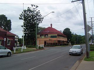
Marburg is a rural town in the City of Ipswich and a locality split between the City of Ipswich and the Somerset Region, both in Queensland, Australia. In the 2016 census, the town had a population of 873 people.

<span class="mw-page-title-main">Aratula</span> Town in Queensland, Australia

Aratula is a rural town and locality in the Scenic Rim Region, Queensland, Australia. In the 2016 census, the locality of Aratula had a population of 532 people.

<span class="mw-page-title-main">Sherwood, Queensland</span> Suburb of Brisbane, Queensland, Australia

Sherwood is a suburb in the City of Brisbane, Queensland, Australia. In the 2021 census, Sherwood had a population of 6,082 people.

<span class="mw-page-title-main">Pullenvale, Queensland</span> Suburb of Brisbane, Queensland, Australia

Pullenvale is a western suburb in the City of Brisbane, Queensland, Australia. In the 2016 census, Pullenvale had a population of 3,179 people.

<span class="mw-page-title-main">Bundamba, Queensland</span> Suburb of Ipswich, Queensland, Australia

Bundamba is a suburb of Ipswich in the City of Ipswich, Queensland, Australia. In the 2016 census Bundamba had a population of 6,514 people.

<span class="mw-page-title-main">Booval, Queensland</span> Suburb of Ipswich, Queensland, Australia

Booval is a suburb of Ipswich in the City of Ipswich, Queensland, Australia. In the 2016 census Booval had a population of 2,622 people.

<span class="mw-page-title-main">Woodend, Queensland</span> Suburb of Ipswich, Queensland, Australia

Woodend is an inner suburb of Ipswich in the City of Ipswich, Queensland, Australia. In the 2021 census, Woodend had a population of 1,483 people.

<span class="mw-page-title-main">Brassall, Queensland</span> Suburb of Ipswich, Queensland, Australia

Brassall is a suburb in the City of Ipswich, Queensland, Australia. As of the 2021 census, Brassall had a population of 12,115 people.

<span class="mw-page-title-main">Sadliers Crossing, Queensland</span> Suburb of Ipswich, Queensland, Australia

Sadliers Crossing is a suburb of Ipswich in the City of Ipswich, Queensland, Australia. In the 2016 census, Sadliers Crossing had a population of 1,366 people.

<span class="mw-page-title-main">West Ipswich, Queensland</span> Suburb of Ipswich, Queensland, Australia

West Ipswich is a suburb of Ipswich in the City of Ipswich, Queensland, Australia. In the 2016 census, West Ipswich had a population of 494 people.

<span class="mw-page-title-main">Redbank, Queensland</span> Suburb of Ipswich, Queensland, Australia

Redbank is a suburb in the City of Ipswich, Queensland, Australia. In the 2016 census, Redbank had a population of 1,834 people.

<span class="mw-page-title-main">Bellbird Park, Queensland</span> Suburb of Ipswich, Queensland, Australia

Bellbird Park is a suburb in the City of Ipswich, Queensland, Australia. In the 2021 census, Bellbird Park had a population of 9,191 people.

<span class="mw-page-title-main">Walloon, Queensland</span> Town in Queensland, Australia

Walloon is a town and rural residential locality in the City of Ipswich, Queensland, Australia. In the 2021 census, the locality of Walloon had a population of 2,305 people.

<span class="mw-page-title-main">Haigslea, Queensland</span> Suburb of Ipswich, Queensland, Australia

Haigslea is a locality split between the City of Ipswich and the Somerset Region in South East Queensland, Australia. In the 2021 census, Haigslea had a population of 507 people.

<span class="mw-page-title-main">Willowbank, Queensland</span> Suburb of City of Ipswich, Queensland, Australia

Willowbank is a rural locality in the City of Ipswich, Queensland, Australia. In the 2021 census, Willowbank had a population of 1,351 people.

Jeebropilly is a rural locality in the City of Ipswich, Queensland, Australia. In the 2021 census, Jeebropilly had "no people or a very low population".

<span class="mw-page-title-main">Kalbar, Queensland</span> Town in Queensland, Australia

Kalbar is a rural town and locality in the Scenic Rim Region, Queensland, Australia. In the 2016 census, the locality of Kalbar had a population of 1,093 people.

<span class="mw-page-title-main">Harrisville, Queensland</span> Town in Queensland, Australia

Harrisville, locally known as the town of churches, is a rural town and locality in the Scenic Rim Region, Queensland, Australia. In the 2016 census, the locality of Harrisville had a population of 613 people.

<span class="mw-page-title-main">Coulson, Queensland</span> Suburb of Scenic Rim Region, Queensland, Australia

Coulson is a rural locality in the Scenic Rim Region, Queensland, Australia. In the 2021 census, Coulson had a population of 168 people.

References

  1. 1 2 "2021 Raceview, Census All persons QuickStats". www.abs.gov.au. Australian Bureau of Statistics. Retrieved 28 March 2024.
  2. 1 2 "Raceview – suburb in City of Ipswich (entry 45071)". Queensland Place Names. Queensland Government . Retrieved 13 February 2022.
  3. 1 2 Australian Bureau of Statistics (28 June 2022). "2021 Community Profiles: Raceview (SSC)". 2021 Census of Population and Housing. Retrieved 28 March 2024. OOjs UI icon edit-ltr-progressive.svg
  4. 1 2 "Queensland Globe". State of Queensland . Retrieved 18 February 2022.
  5. "Ipswich History Time Line" (PDF). Ipswich City Council . p. 1. Archived (PDF) from the original on 17 September 2021. Retrieved 18 February 2022.
  6. 1 2 Queensland Family History Society (2010), Queensland schools past and present (Version 1.01 ed.), Queensland Family History Society, ISBN   978-1-921171-26-0
  7. "NEWS OF WAR GRAVES VALUED IN U.S.A." Queensland Times . No. 18, 190. Queensland, Australia. 20 March 1945. p. 3 (DAILY). Archived from the original on 18 February 2022. Retrieved 18 February 2022 via National Library of Australia.
  8. "Ipswich Mother Going To U.S." The Courier-mail . No. 3280. Queensland, Australia. 30 May 1947. p. 5. Archived from the original on 18 February 2022. Retrieved 18 February 2022 via National Library of Australia.
  9. "Memorial Wreaths Prelude To U.S. Tour". Sunday Mail . No. 893. Queensland, Australia. 1 June 1947. p. 5. Archived from the original on 18 February 2022. Retrieved 18 February 2022 via National Library of Australia.
  10. "WORK AT U.S. CEMETERY SHOULD FINISH TO-DAY". Queensland Times . No. 19, 046. Queensland, Australia. 20 December 1947. p. 2 (DAILY). Archived from the original on 18 February 2022. Retrieved 18 February 2022 via National Library of Australia.
  11. "American War Cemetery" (PDF). Ipswich City Council . Archived (PDF) from the original on 14 April 2021. Retrieved 18 February 2022.
  12. "United States Armed Forces Military Cemetery". Monument Australia. Archived from the original on 18 February 2022. Retrieved 18 February 2022.
  13. "USAF Military Cemetery Ipswich, Ipswich, Queensland, during WW2". Australia@War. Archived from the original on 14 May 2021. Retrieved 18 February 2022.
  14. "PUBLIC HALL AT RACEVIEW". Queensland Times . No. 18, 938. Queensland, Australia. 16 August 1947. p. 2 (DAILY). Archived from the original on 20 February 2022. Retrieved 20 February 2022 via National Library of Australia.
  15. Google (20 February 2022). "Raceview Public Hall (former?)" (Map). Google Maps . Google. Retrieved 20 February 2022.
  16. "List of cinemas and theatres in Queensland" (PDF). Cinema and Theatre Historical Society of Australia. Archived (PDF) from the original on 9 April 2021. Retrieved 18 February 2022.
  17. "Starline Drive-In in Ipswich, AU - Cinema Treasures". cinematreasures.org. Archived from the original on 17 January 2021. Retrieved 18 February 2022.
  18. 1 2 3 "State and non-state school details". Queensland Government. 9 July 2018. Archived from the original on 21 November 2018. Retrieved 21 November 2018.
  19. "Raceview State School". Raceview State School. 5 May 2020. Archived from the original on 19 March 2021. Retrieved 18 February 2022.
  20. 1 2 "ACARA School Profile 2018". Australian Curriculum, Assessment and Reporting Authority. Archived from the original on 27 August 2020. Retrieved 28 January 2020.
  21. "Bethany Lutheran Primary School". Archived from the original on 9 December 2018. Retrieved 21 November 2018.
  22. 1 2 "Building areas - Queensland". Queensland Open Data. Queensland Government. 17 November 2020. Archived from the original on 23 October 2020. Retrieved 17 November 2020.
  23. 1 2 3 4 "Building points - Queensland". Queensland Open Data. Queensland Government. 17 November 2020. Archived from the original on 25 November 2020. Retrieved 25 November 2020.
  24. 1 2 3 4 5 6 7 8 9 10 11 12 13 14 "Land for public recreation - Queensland". Queensland Open Data. Queensland Government. 20 November 2020. Archived from the original on 22 November 2020. Retrieved 22 November 2020.
  25. "Cemetery Areas - Queensland". Queensland Open Data. Queensland Government. 12 November 2020. Archived from the original on 15 November 2020. Retrieved 12 November 2020.