Related Research Articles

A thrust fault is a break in the Earth's crust, across which older rocks are pushed above younger rocks.

The Tian Shan, also known as the Tengri Tagh or Tengir-Too, meaning the Mountains of Heaven or the Heavenly Mountain, is a large system of mountain ranges located in Central Asia. The highest peak in the Tian Shan is Jengish Chokusu, at 7,439 metres (24,406 ft) high. Its lowest point is the Turpan Depression, which is 154 m (505 ft) below sea level.

The Transverse Ranges are a group of mountain ranges of southern California, in the Pacific Coast Ranges physiographic region in North America. The Transverse Ranges begin at the southern end of the California Coast Ranges and lie within Santa Barbara, Ventura, Los Angeles, San Bernardino, Riverside and Kern counties. The Peninsular Ranges lie to the south. The name Transverse Ranges is due to their east–west orientation, making them transverse to the general northwest–southeast orientation of most of California's coastal mountains.

In geology, a rift is a linear zone where the lithosphere is being pulled apart and is an example of extensional tectonics.
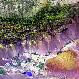
The Turpan Depression or Turfan Depression, is a fault-bounded trough located around and south of the city-oasis of Turpan, in the Xinjiang Autonomous Region in far Western China, about 150 kilometres (93 mi) southeast of the regional capital Ürümqi. It includes Lake Ayding, −154 metres (−505 ft), the second or third lowest depression on Earth. By some measures, it is also the hottest and driest area in China during the summer.

Sedimentary exhalative deposits are zinc-lead deposits originally interpreted to have been formed by discharge of metal-bearing basinal fluids onto the seaflor resulting in the precipitation of mainly stratiform ore, often with thin laminations of sulphide minerals. SEDEX deposits are hosted largely by clastic rocks deposited in intracontinental rifts or failed rift basins and passive continental margins. Since these ore deposits frequently form massive sulfide lenses, they are also named sediment-hosted massive sulfide (SHMS) deposits, as oposed to volcanic-hosted massive sulfide (VHMS) deposits. The sedimentary appearance of the thin laminations led to early interpretations that the deposits formed exclusively or mainly by exhalative processes onto the seafloor, hence the term SEDEX. However, recent study of numerous deposits indicates that shallow subsurface replacement is also an important process, in several deposits the predominant one, with only local if any exhalations onto the seafloor. For this reason, some authors prefer the term "Clastic-dominated zinc-lead deposits". As used today, therefore, the term SEDEX is not to be taken to mean that hydrothermal fluids actually vented into the overlying water column, although this may have occurred in some cases

A monocline is a step-like fold in rock strata consisting of a zone of steeper dip within an otherwise horizontal or gently-dipping sequence.
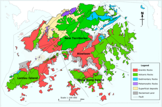
The geology of Hong Kong is dominated by igneous rocks formed during a major volcanic eruption period in the Mesozoic era. It made up 85% of Hong Kong's land surface and the remaining 15% are mostly sedimentary rocks located in the northeast New Territories. There are also a very small percentage of metamorphic rocks in New Territories. These are formed by deformation of pre-existing sedimentary rocks which changed its mineral assemblages (metamorphism).
The Orcadian Basin is a sedimentary basin of Devonian age that formed mainly as a result of extensional tectonics in northeastern Scotland after the end of the Caledonian orogeny. During part of its history, the basin was filled by a lake now known as Lake Orcadie. In that lacustrine environment, a sequence of finely bedded sedimentary rocks was deposited, containing well-preserved fish fossils, with alternating layers of mudstone and coarse siltstone to very fine sandstone. These flagstones split easily along the bedding and have been used as building material for thousands of years. The deposits of the Orcadian Basin form part of the Old Red Sandstone (ORS). The lithostratigraphic terms lower, middle and upper ORS, however, do not necessarily match exactly with sediments of lower, middle and upper Devonian age, as the base of the ORS is now known to be in the Silurian and the top in the Carboniferous.

The Dead Sea Transform (DST) fault system, also sometimes referred to as the Dead Sea Rift, is a series of faults that run from the Maras Triple Junction to the northern end of the Red Sea Rift. The fault system forms the transform boundary between the African Plate to the west and the Arabian Plate to the east. It is a zone of left lateral displacement, signifying the relative motions of the two plates. Both plates are moving in a general north-northeast direction, but the Arabian Plate is moving faster, resulting in the observed left lateral motions along the fault of approximately 107 km. A component of extension is also present in the southern part of the transform, which has contributed to a series of depressions, or pull-apart basins, forming the Gulf of Aqaba, Dead Sea, Sea of Galilee, and Hula basins.
The 1911 Kebin earthquake, or Chon-Kemin earthquake, struck Russian Turkestan on 3 January. Registering at a 7.7 magnitude, it killed 452 people, destroyed more than 770 buildings in Almaty, Kazakhstan, and resulted in 125 miles (201 km) of surface faulting in the valleys of Chon-Kemin, Chilik and Chon-Aksu.

The geology of Russia, the world's largest country, which extends over much of northern Eurasia, consists of several stable cratons and sedimentary platforms bounded by orogenic (mountain) belts.
Tectonic subsidence is the sinking of the Earth's crust on a large scale, relative to crustal-scale features or the geoid. The movement of crustal plates and accommodation spaces created by faulting create subsidence on a large scale in a variety of environments, including passive margins, aulacogens, fore-arc basins, foreland basins, intercontinental basins and pull-apart basins. Three mechanisms are common in the tectonic environments in which subsidence occurs: extension, cooling and loading.

The Tian Shan is a mountain range in central Asia that extends through western China, Kazakhstan, and Kyrgyzstan. The Tian Shan is 2,800 kilometres (1,700 mi) long, and up to 7,400 metres (24,300 ft) high. Throughout the Tian Shan there are several intermontane basins separated by high ranges. Plate tectonic theory makes the assumption that deformation is concentrated along plate boundaries. However, active deformation is observed in the Tian Shan, far from plate boundaries. This apparent contradiction of plate tectonic theory makes the Tian Shan a key place to study the dynamics of intracontinental deformation.

The North Sea is part of the Atlantic Ocean in northern Europe. It is located between Norway and Denmark in the east, Scotland and England in the west, Germany, the Netherlands, Belgium and France in the south.
The South Lokichar Basin is a Cenozoic sedimentary basin in Kenya. It is part of the East African Rift system, although it is no longer active. Since 2012 it has been the location of a series of oil discoveries by Tullow Oil and its partners.
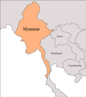
The geology of Myanmar is shaped by dramatic, ongoing tectonic processes controlled by shifting tectonic components as the Indian plate slides northwards and towards Southeast Asia. Myanmar spans across parts of three tectonic plates separated by north-trending faults. To the west, a highly oblique subduction zone separates the offshore Indian plate from the Burma microplate, which underlies most of the country. In the center-east of Myanmar, a right lateral strike slip fault extends from south to north across more than 1,000 km (620 mi). These tectonic zones are responsible for large earthquakes in the region. The India-Eurasia plate collision which initiated in the Eocene provides the last geological pieces of Myanmar, and thus Myanmar preserves a more extensive Cenozoic geological record as compared to records of the Mesozoic and Paleozoic eras. Myanmar is physiographically divided into three regions: the Indo-Burman Range, Myanmar Central Belt and the Shan Plateau; these all display an arcuate shape bulging westwards. The varying regional tectonic settings of Myanmar not only give rise to disparate regional features, but they also foster the formation of petroleum basins and a diverse mix of mineral resources.
The geology of Kyrgyzstan began to form during the Proterozoic. The country has experienced long-running uplift events, forming the Tian Shan mountains and large, sediment filled basins.

Junggar Basin is one of the largest sedimentary basins in Northwest China. It is located in Xinjiang, and enclosed by the Tarbagatai Mountains of Kazakhstan in the northwest, the Altai Mountains of Mongolia in the northeast, and the Heavenly Mountains in the south. The geology of Junggar Basin mainly consists of sedimentary rocks underlain by igneous and metamorphic basement rocks. The basement of the basin was largely formed during the development of the Pangea supercontinent during complex tectonic events from Precambrian to late Paleozoic time. The basin developed as a series of foreland basins – in other words, basins developing immediately in front of growing mountain ranges – from Permian time to the Quaternary period. The basin's preserved sedimentary records show that the climate during the Mesozoic era was marked by a transition from humid to arid conditions as monsoonal climatic effects waned. The Junggar basin is rich in geological resources due to effects of volcanism and sedimentary deposition.

The Hornelen Basin is a sedimentary basin in Vestland, Norway, containing an estimated 25 km stratigraphic thickness of coarse clastic sedimentary rocks of Devonian age. It forms part of a group of basins of similar age along the west coast of Norway between Sognefjord and Nordfjord, related to movement on the Nordfjord-Sogn Detachment. It formed as a result of extensional tectonics as part of the post-orogenic collapse of crust that was thickened during the Caledonian Orogeny towards the end of the Silurian period. It is named for the mountain Hornelen on the northern margin of the basin.
References
- ↑ Cobbold P.R.; Davy P.; Gapais D.; Rosello E.A.; Sadybakasov E.; Thomas J.C.; Tondji Biyo J.J.; de Urreiztieta M. (1993). "Sedimentary basins and crustal thickening". Sedimentary Geology. 86 (1–2): 77–89. doi:10.1016/0037-0738(93)90134-Q.
- ↑ Saint Fleur N.; Feuillet N.; Grandin R.; Jacques E.; Weil-Accardo J.; Klinger Y. (2015). "Seismotectonics of southern Haiti: A new faulting model for the 12 January 2010 M7.0 earthquake" (PDF). Geophysical Research Letters. 42 (23): 10, 273–10, 281. doi: 10.1002/2015GL065505 .
- ↑ Vermeesch P.; Poort J.; Duchkov A.D.; Klerkx J.; De Batist M. (2004). "Lake Issyk-Kul (Tien Shan): Unusually low heat flow in an active intermontane basin" (PDF). Russian Geology and Geophysics. 45 (5): 616–625.